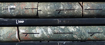
Rian Dutch1,2, Mark Pawley1, Tom Wise1, Liz Jagodzinski1, Luke Tylkowski1, Amy Lockheed1 and Sarlae McAlpine3
1 Geological Survey of South Australia, Government of South Australia
2 School of Physical Sciences, The University of Adelaide
3 Geoscience Australia
Download this article as a PDF (10.2 MB); cite as MESA Journal 87, pages 4–14
Introduction
Figure 1 Regional total magnetic intensity (TMI) image showing the location of the Coompana Province with respect to the surrounding geological provinces and highlighting the large reversely polarised Coompana Magnetic Anomaly.
The Coompana Province is an approximately 200,000 km2 region of crystalline basement that lies between the Gawler Craton to the east, the Musgrave Province to the north and the Madura Province (Spaggiari et al. 2012) to the west (Fig. 1). However, the Coompana Province is entirely buried by Phanerozoic sediments, including the Nullarbor Limestone which forms the foundation for the Nullarbor Plain, one of Australia’s most iconic landscapes. Because of this pervasive sedimentary cover, the Coompana Province is one of the true frontiers of geological knowledge of the Australian continent.
Prior to 2013, the sum of our geophysical knowledge of the Coompana Province was constrained by wide-spaced gravity data acquired in 1965 and 1970, and 1,600 and 3,200 m line-spaced magnetic data acquired in 1970–1972 (Eucla Basin surveys) and 1982 (Officer Basin survey), respectively. Despite the coarseness of this data, a number of interesting geophysical anomalies were identified, including the ~50 km diameter reversely polarised Coompana Magnetic Anomaly (Fig. 1), and became targets for early mineral exploration work. Follow-up ground magnetic and gravity surveys conducted during the late 1970s led to a number of exploration drillholes being sunk during the early 1980s (e.g. Carpentaria Exploration Co. Pty Ltd 1982a, 1982b; Shell Co. of Australia Ltd 1983). Of the drillholes sunk during this period, only two reverse circulation and two diamond drillholes intersected basement. These four drillholes, together with three water bores drilled using a cable tool during the 1890s (Alballa-Karoo, Guinewarra Bore and Nullarbor Plains 6) and two petroleum wells (Eucla 1 and Mallabie 1), were the only physical rock samples of the Coompana basement (Fig. 2).
Figure 2 Distribution of existing drillholes in the Coompana Province prior to the Coompana Drilling Project shown over surface geology which is dominated by Phanerozoic-aged cover and basins.
In 2013 the Geological Survey of Western Australia undertook a stratigraphic drilling program in the western Coompana Province (‘FOR’ holes, Fig. 2; Spaggiari and Smithies 2015). This new data began to shed light on the evolution of the region, indicating a complex multiphase history beginning with interpreted Paleoproterozoic oceanic crust formation, followed by a series of magmatic and deformation events, associated with interpreted subduction and crustal reworking throughout the Mesoproterozoic (Dutch et al. 2016a; Kirkland et al. 2017; Spaggiari and Smithies 2015). Integrated with reanalysis of the existing drillholes, this data has begun to build a stratigraphic framework for the western, and parts of the eastern, Coompana Province (Table 1).
Despite this work, understanding of the geology of the South Australian portion of the Coompana Province and its relation to surrounding Proterozoic terranes remains extremely poor. A number of fundamental questions remain unanswered including:
- What are the age and types of lithologies that constitute the basement?
- What is the tectonic and crustal evolution of those rocks?
- What is the relationship between the Coompana Province and the surrounding Proterozoic terranes?
- Are there potential fluid pathways conducive to the formation of mineralisation?
- What is the thickness and geochemical transparency of the cover sediments?
The lack of precompetitive geoscience knowledge and data in the Coompana Province has meant the exploration risk profile was too high for explorers in this frontier province, with no further exploration work conducted since the early 1980s programs.
The Geological Survey of South Australia, together with collaborative partners including Geoscience Australia and CSIRO, have undertaken a program of precompetitive geoscience data acquisition since 2013 to address the data and knowledge gaps in this region.
This process began with the acquisition of the 13GA-EG1 Eucla–Gawler deep crustal seismic and magnetotelluric line (Holzschuh 2015; Thiel, Wise and Duan 2015). In 2015 the Australian Lithospheric Architecture Mapping Project (AusLAMP) magnetotelluric data acquisition was completed across the Far West of South Australia as a collaboration between the University of Adelaide, Geological Survey and Geoscience Australia (Thiel et al. 2016). Also in 2015, the Geological Survey in collaboration with Geoscience Australia, flew the Coompana Magnetic and Radiometric Survey increasing the magnetic line density to between 400 and 200 m and acquiring a complete radiometric dataset across the Far West (Heath, Reed and Katona 2015). In 2016 a gravity survey acquired over 13,000 new gravity stations at a combination of 2, 1 and 0.5 km spacing across the southern Coompana Province (Heath and Wise 2017).
This regional geophysical data acquisition has provided a wealth of new data to image the Coompana Province in South Australia. However, while the geophysical data provides some insight into the physical properties of the buried basement, the geology still remained largely unconstrained due to a lack of physical samples. Therefore, a program of scientific drilling was undertaken in 2017 with the aim of collecting drill core samples from the crystalline basement beneath the Nullarbor Plain of South Australia.
This article outlines the process undertaken to plan and retrieve new basement samples and describes the rocks retrieved from the $3 million Coompana Drilling Project.
Table 1 Summary of basement-intersecting drillholes in the Coompana Province
| Drillhole | Sample type | Geology | Unit | Magmatic age (Ma) | Metamorphic age (Ma) | Geochron reference | Drillhole reference |
| Guinewarra Bore | Cuttings | Granitic basement | Moodini Supersuite? | 1158 ± 12 | — | 1 | — |
| Alballa-Karoo | Cuttings | Granitic basement | ? | — | — | — | — |
| Nullarbor Plains 6 | Cuttings | Granitic basement | ? | — | — | — | — |
| FOR004* | Diamond core | Granitic basement | Toolgana Supersuite | 1613 ± 4; 1611 ± 7 | 1179 ± 10 | 2 | 3 |
| FOR008* | Diamond core | Granitic basement | Toolgana Supersuite | 1613 ± 13; 1604 ± 6 | 1150 ± 10 | 2 | 3 |
| Kutjara 1 | Cuttings | Granitic basement | Toolgana Supersuite | 1591 ± 11 | 1167 ± 7 | 4 | 5 |
| Mallabie 1 | Diamond core | Granitic basement | Undawidgi Supersuite | 1500 ± 8 | — | 1 | 6 |
| FOR012* | Diamond core | Granitic basement | Undawidgi Supersuite | 1499 ± 9 | — | 2 | 3 |
| FOR011* | Diamond core | Granitic basement | Undawidgi Supersuite | 1488 ± 4 | 1174 ± 12 | 2 | 3 |
| FOR010* | Diamond core | Granitic basement | Undawidgi Supersuite | 1487 ± 9 | — | 2 | 3 |
| Mulyawara 1 | Cuttings | Granitic basement | Moodini Supersuite | 1168 ± 6 | — | 4 | 7 |
| Eucla 1* | Cuttings | Granitic basement | Moodini Supersuite | 1140 ± 8 | — | 2 | 3 |
| CD 1 | Diamond core | Mafic volcanics and intrusives | Neoproterozoic volcanics | 859 ± 66 | — | 8 | 9 |
| BN 2 | Diamond core | Mafic volcanics and intrusives | Neoproterozoic volcanics? | — | — | — | 10 |
| BN 1 | Cuttings | Mafic volcanics and intrusives | Neoproterozoic volcanics? | — | — | — | 10 |
| KN 1 | Cuttings | Mafic volcanics and intrusives | Neoproterozoic volcanics? | — | — | — | 11 |
* Western Australian drillhole
References: 1 Fraser and Neumann (2016); 2 Wingate et al. (2015); 3 Spaggiari and Smithies (2015); 4 Neumann and Korsch (2014); 5 Baily et al. (2012a); 6 Outback Oil Company (1969); 7 Baily et al. (2012b); 8 Travers (2015); 9 Shell Co. of Australia (1983); 10 Carpentaria Exploration Co. (1982a); 11 Carpentaria Exploration Co. (1982b).
Drilling program
Target selection
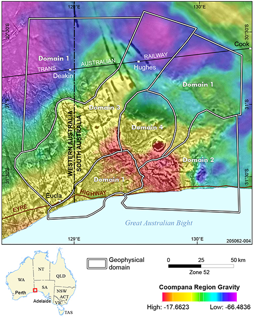
Figure 3 Integrated regional and newly acquired Bouguer gravity (colour) and first vertical derivative Coompana magnetic image (grey scale) across the southern Coompana Province. The various domains are interpreted from the regional geophysical data and are thought to represent areas of different lithology or geological history.
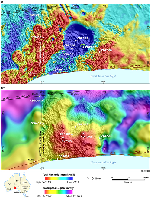
Using newly acquired data from the Coompana airborne magnetic and gravity surveys, the Coompana Province was subdivided into a series of domains with distinct geophysical characteristics (Fig. 3; see Wise, Pawley and Dutch, 2015, for preliminary domain definitions based on the Coompana magnetic survey). These domains are interpreted to represent regions with distinct lithologies and geological histories. The identified domains are consistent with the crustal blocks recognised in the 13GA-EG1 deep crustal seismic profile (Dutch et al. 2016b). The South Australian Coompana Province also hosts a number of intriguing distinct geophysical anomalies including the enigmatic Coompana Magnetic Anomaly (Fig. 4a; Wise, Pawley and Dutch 2015). This ~50 km wide, deep-seated, remnantly magnetised anomaly is associated with a low-density signature.
Drillhole locations were planned to intercept as many of the different geophysical domains as possible (Fig. 3). These domains include:
- Moderate magnetic intensity, low-density domains with a defined NNE-trending fabric which likely represent the oldest protoliths in the region (domain 1).
- A variable, mottled magnetic signature domain with both high and low densities which may represent reworked basement by subsequent granitic intrusions (domain 2).
- A prominent NE-trending line of magnetic intrusions that bisects the province (domain 3).
- The main remnantly magnetised Coompana Magnetic Anomaly and a number of possibly associated smaller satellite intrusions located coincident and adjacent to the main anomaly, but which are associated with density highs (domain 4).
Pre-drilling geophysics
Figure 4 Location of the eight Coompana Drilling Project holes shown over: (a) reduction to pole TMI image from the new Coompana magnetic survey; and (b) combination regional and new Coompana gravity survey data. Note the coincidence of the strongly reversely magnetised Coompana Magnetic Anomaly with a large density low in the gravity data.
Prior to the commencement of drilling, a number of geophysical techniques were trialled to ascertain their effectiveness at determining the thickness and nature of the cover units. This was an important step in the drill planning workflow as it allowed better planning of the proposed drillholes. A combination of audio magnetotellurics (Jiang et al. 2017) and active seismic (reflection and refraction; Holzschuh et al. in prep.) were undertaken at selected proposed drillsites to see if the techniques were able to resolve the cover thickness or any structure within the cover. In addition to trialling the above techniques, depth to magnetic basement estimates were also calculated by modelling individual magnetic sources using the newly acquired Coompana airborne magnetic data (Foss et al. 2017).
The Nullarbor Plain is known for its large and numerous cave systems. Because of this aspect, prior to drilling a series of microgravity surveys were undertaken at each site in an attempt to locate the presence of large, blind, cavities that may be in the vicinity of the drill collar (Heath et al. 2017). The surveys were undertaken using two Scintrex CG5 gravity meters on a regular grid pattern with stations spaced at 10 m intervals. The total gravity field was measured and then the regional trend removed in post-processing to highlight the near-surface density variation. The results show areas of lower density in the near surface that may indicate the location of subsurface cavities and allowed for the drill collar to be moved to minimise the potential risk of major drilling problems associated with large cavities.
Drilling methodology
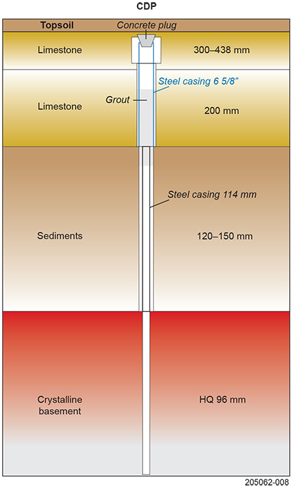
Figure 5 Schematic bore hole plan showing the three different levels of casing and hole diameters used for the Coompana Drilling Project.
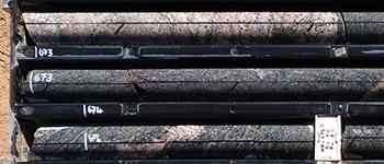
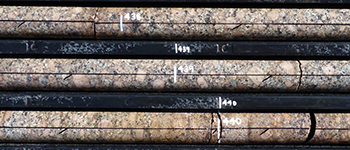
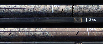
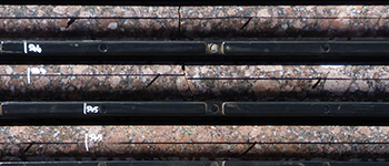
The drilling contract was awarded to South Australian based Boart Longyear Australia via a competitive tender process. Drilling commenced in early April 2017 with the drilling of the first hole CDP001 and was completed in mid-September 2017. Eight holes were drilled for a total of 4,565 m including more than 1,871 m of diamond core (Fig. 4). All holes were drilled at a slight inclination of either –80° or –85° towards 000° (with the exception of CDP007 which was drilled towards 270°), with the core being orientated using Boart Longyear’s Tru-CoreTM orientation tool.
Because of the likelihood of lost circulation and the potential to damage sensitive cave systems and habitats, drilling used a combination of techniques and multiple casing strings to achieve the desired basement core samples and ensure the best chance for successfully completing each hole with minimal environmental impact (Fig. 5). A primary precollar through the limestone sequences was drilled using air and a combination of hammer and rock rolling until through the area most likely to contain voids. Little to no sample returns were recovered while drilling this section which was then cased to isolate the cave systems from the collar. Then standard rotary mud drilling using a solids removal unit and above-ground tanks was used to basement. No in-ground sumps were required, reducing the surficial environmental impact of the drilling program and mitigating the need to conduct extensive earthworks though hard limestone. A second string of casing was run to basement before commencing HQ3 diamond coring. Core samples of between 300 and 100 m of crystalline basement were retrieved.
Development of an effective bore hole plan was instrumental to the success of the program. All eight holes were successfully drilled to target depth and retrieved the desired basement intersections. No holes were lost during the program and no environmental incidents occurred.
Geology of the crystalline basement from the Coompana Drilling Project
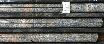
Drilling has recovered a range of distinct lithologies from the different geophysical domains. Units intersected include migmatitic orthogneisses, felsic intrusions, mafic intrusions and volcanics. These units can be placed in a relative chronology based on observed crosscutting relationships and are described in detail below by this inferred stratigraphy, rather than by drillhole.
Migmatitic rocks
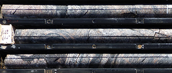
The interpreted oldest rocks are migmatites, including metatexites and diatexites, intersected in geophysical domain 1 both in the north and south of the targeted Coompana Province (Fig. 3). The metatexites, or migmatitic gneisses, were intersected in drillholes CDP001 and CDP006 (Fig. 4). These rocks are well layered with leucocratic continuous layers and discontinuous augen (or lenses) that are separated by a melanocratic groundmass (Fig. 6a–c). The layers are generally defined by recrystallised aggregates of feldspar and quartz. The augen can often be formed by recrystallised feldspar, or recrystallised aggregates of feldspar and quartz that may be the remnants of feldspar phenocrysts, suggesting the protolith was a porphyritic granite (Fig. 6b). The melanocratic component comprises layers of fine-grained mafic minerals (biotite, possibly hornblende and minor magnetite) that are aligned parallel to the layering. The layering is locally folded into open structures with shallowly dipping axial planes (Fig. 6b). In places, the rock is less uniform and can be dominated by either:
- a mafic-rich end-member where isolated leucocratic augen and layers of feldspar and quartz are hosted by a melanocratic groundmass of aligned mafic minerals
- a felsic-rich end-member with remnants of the gneiss and mafic schlieren in a feldspar- and quartz-dominated, massive, granitic groundmass.
The diatexites were intersected in CDP004 (Fig. 4). In drill core, the diatexites are fine to very coarse grained, and composed of variable proportions of feldspar, quartz, hornblende and biotite (Fig. 6d–f). The rocks are compositionally and texturally heterogeneous, comprising a leucocratic, medium to very coarse grained, massive, igneous-textured groundmass that contains a mafic component. This mafic component ranges from blocks of medium- to fine-grained mesocratic foliated rock or gneiss (i.e. schollen; Fig. 6d–e) that are up to 30 cm wide and often back-veined by the groundmass, to irregular bands with greater concentration of mafic minerals (i.e. schlieren; Fig. 6f).
Figure 6 Migmatitic rocks, Coompana Drilling Project.
Figure 6a Metatexite with aligned leucocratic layers and augen that are separated by melanocratic (mafic-rich) layers, CDP001. (Photo 416608)
Figure 6e Diatexite showing the parallel mafic schlieren and dark, fine-grained mafic schollen (lower left) that have been folded into open structures with shallowly dipping axial planes, CDP004. (Photo 416612)
Felsic intrusive rocks
The next package comprises a range of felsic intrusive rocks (Fig. 7a–c). These include the massive, medium to very coarse grained, porphyritic syenogranite to granodiorites that were intersected in CDP003 and CDP005 (Fig. 4). The rocks contain common equant to tabular, poikilitic K-feldspar megacrysts (up to 5 cm across), and plagioclase and quartz phenocrysts in a groundmass of K-feldspar, quartz and plagioclase (Fig. 7a–c). Mafic minerals (biotite, hornblende and magnetite) form small equant to interstitial aggregates. The K-feldspar megacrysts commonly display Rapakivi textures, such as rounding, and more calcic overgrowths (Fig. 7b).
Drillholes CDP003 and CDP005 targeted large, overlapping, ovoidal, magnetic bodies that are prominent on the aeromagnetic images and define geophysical domain 3 (Fig. 3). These bodies were interpreted as plutons which intrude into domain 1 rocks and form a NE-striking well-defined belt that continues to the northeast where it runs along the northwestern side of the Gawler Craton (Fig. 1).
The felsic intrusive suite also includes minor, thin sheets (up to 3 m wide) that range from microsyenogranite to microsyenite in CDP003 and CDP005. These sheets have sharp, irregular contacts that follow the grain boundaries of the host granites, suggesting that the host granites were incompletely crystallised, and the microsyenogranite represents late-stage magmas (Fig. 7b).
Microsyenites are observed within the diatexite in CDP004 (Fig. 6f). The microsyenites are brown to dark green, fine- to medium-grained, weakly inequigranular to seriate-textured, and contain feldspar, hornblende and biotite. The rock generally has a foliation that is defined by aligned biotite flakes in an equigranular groundmass. The microsyenites contain rare, irregular centimetre-wide feldspar xenocrysts, and in places contain common millimetre- to centimetre-scale leucosomes that are subparallel to the foliation (Fig. 6f).
Figure 7 Felsic and mafic rocks, Coompana Drilling Project.
Figure 7a Megacrystic syenogranite showing the very large, blocky subhedral K-feldspar phenocrysts, CDP003. (Photo 416614)
Figure 7c Megacrystic monzogranite showing the very large, blocky subhedral K-feldspar and plagioclase phenocrysts, CDP005. (Photo 416616)
Figure 7g Basalt showing the chlorite-filled amygdales and plagioclase laths, CDP008. (Photo 416620)
Mafic rocks
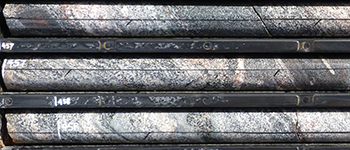
The felsic intrusive rocks are cut by mafic intrusive rocks that correspond to remnantly magnetised bodies prominent on aeromagnetic images. Drillholes CDP002 and CDP007 targeted these magnetic features (Fig. 4). CDP002, which targeted geophysical domain 4 (Fig. 3), intersected fine- to medium-grained, inequigranular, massive, dark grey-green to more leucocratic dolerite and gabbro. The dolerite contains randomly oriented prismatic plagioclase intergrown with olivine (often replaced by actinolite and magnetite), clinopyroxene and amphibole (Fig. 7d). The gabbroic rocks are dominated by the mafic minerals, and likely represent cumulate phases (Fig. 7e). These rocks also contain interstitial patches of fine-grained mesostasis composed of K-feldspar, quartz, magnetite and amphibole (Fig. 7d).
CDP007 targeted a small remnantly magnetised body along the margin of geophysical domains 1 and 3 (Fig. 3). This drillhole intersected homogenous, aphanitic to medium-grained, inequigranular basalt (Fig. 7f). This rock comprises randomly oriented plagioclase prisms (often with ‘swallow-tail’ terminations), blocky clinopyroxene, and chlorite pseudomorphs (after orthopyroxene) in a groundmass of mesostasis. The mesostasis is composed of plagioclase, clinopyroxene, magnetite and quartz.
Minor metre-scale basalt sheets sharply cut the porphyritic syenogranite in CDP003. The basalt is dark grey-green, fine-grained to aphanitic, and generally equigranular, although there are rare plagioclase phenocrysts up to 1 cm across. The margins of the basalt sheets have fine veins and weak discolouration along them, suggesting reactivation and fluid flow.
CDP008 targeted the basement in geophysical domain 2 (Fig. 3). This drillhole intersected a thick package of 2–20 m thick basalt lava flows that were interpreted to be the eruptive equivalents of the mafic rocks in CDP002 and CDP007. The basalts are dark brown-green, massive, variable amygdaloidal, and range from fine- to medium-grained with intervals containing common ~5 mm long plagioclase laths (Fig. 7g). There are two types of amygdales: large (10 mm) zoned quartz–calcite-filled amygdales, and smaller (3–10 mm) dark green possibly chlorite-filled amygdales (Fig. 7g). The flow tops are variably brecciated, with the intensity decreasing towards the middle of the flow. Angular basalt clasts are suspended in a fine-grained, hematite-rich matrix, and patchy, carbonate veining/infill is common in brecciated intervals (Fig. 7h). The basalt is heavily quartz–calcite veined for ~8 m below the basement unconformity. Flow tops, and rarely bases, are often strongly hematite–chlorite altered, whilst mid-flow regions remain relatively unaltered to weakly chlorite altered.
Alteration and brecciation
The rocks exhibit common sericitisation, iron alteration, chloritisation and silicification, which are variably developed and range from locally selective to pervasive.
Selective alteration was observed in most of the cores including sericitisation of feldspars, hematite dusting and chloritic alteration of mica and amphiboles (Fig. 8a; Mason 2018).
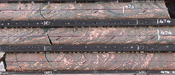
Alteration is particularly well developed in CDP006, which targeted the Palinar Shear Zone, a crustal-scale west-dipping structure that marks the boundary between interpreted geophysical domains 1 and 3 (Dutch et al. 2016b). Sericite–chlorite is the most prominent style of pervasive alteration, which locally resulted in a dark green-grey to black, fine-grained metasomatite rock (Fig. 8b). The metasomatite locally contains ‘worm-like’ early quartz ribbons that are likely remnant leucosomes from the host gneisses (Fig. 8c), angular white quartz blocks that represent an earlier stage of disaggregated quartz veining (Fig. 8d), and blocks of hematite-altered granite.
A breccia zone in CDP006 has intensely sericite–chlorite–quartz–leucoxene altered rock brecciated with a quartz–chlorite hydrothermal cement (Fig. 8c). The quartz in the cement ranges from angular, fine-grained, massive fragments, bladed subhedral quartz that encloses the fragments, and crustiform prisms that project into cavities. The cavities were then filled with massive, very fine grained chlorite (Mason 2018). These textures indicate progressive fragmentation and fluid flow. A basalt sheet at 480.75–481.92 m has been brecciated and altered. The fluid altered the basalt resulting in an assemblage of albite–chlorite–hematite–leucoxene, and crystallised to form a groundmass of mostly albite–quartz–chlorite between the blocks (Mason 2018).
These observations suggest that the rocks intersected in CDP006 experienced several stages of fault reactivation and generations of fluid flow after the mafic magmatic stage.
Figure 8 Alteration and brecciation textures, CDP006.
Figure 8a Metatexite with selective alteration, including the sericite replacement of plagioclase in a leucosome (see lower left of photograph), local hematite-alteration of the leucosomes, and chlorite replacement of the biotite-rich parts of the metatexite. (Photo 416622)
Figure 8c The upper part of the photograph shows the dark green-grey sericite–chlorite metasomatite forming angular blocks within a cement of bladed subhedral quartz, which are then cut by a later stage of white quartz at upper left. The lower part of the photograph shows the ‘worm-like’ quartz-rich aggregates in the metasomatite that are interpreted to represent remnants of the leucosomes in the precursor metatexite. (Photo 416624)
Summary and current work program
The Coompana Drilling Project was the culmination of a number of years of precompetitive geophysical data acquisition, analysis and interpretation. This project set out to retrieve new basement samples from beneath the Nullarbor Plain and allow us to begin to place new geological constraints on the evolution and prospectivity of this unexplored region.
On completion of the drilling program, all core and cutting samples were relocated to the South Australia Drill Core Reference Library and structurally and lithologically re-logged. Non-destructive chemical and mineralogical data has now been acquired on the core using the HyLoggerTM and MinalyzeTM systems housed at the Core Library. More than 200 physical samples of the different lithologies have been taken and sent off for full suite lithogeochemical data. A total of 35 samples have been submitted for samarium–neodymium isotopic analysis at the University of Adelaide to help constrain the crustal evolution of the province. Twelve samples have been processed for zircon geochronology using the SHRIMP IIe instrument at Geoscience Australia and hafnium isotopic analysis at Curtin University.
These mineralogical, geochemical and isotopic datasets are currently being compiled and analysed. The results of this analysis program will be presented at an open day hosted at the South Australia Drill Core Reference Library on 1 August 2018.
Acknowledgements
The Geological Survey of South Australia acknowledges the Mirning People, and the members of the Far West Coast Aboriginal Corporation, who are the traditional owners of this land. In particular, Clem Lawrie, James Peel, John Mungee, Neville Miller and Peter Miller are thanked for undertaking on-country site inspections. The Geological Survey would also like to acknowledge the hard and constructive work undertaken by staff of the Department of Environment, Water and Natural Resources and the Alinytjara Wilurara Natural Resources Management, including the members of the Nullarbor Parks Advisory Committee who provided the necessary approvals to undertake this project within the Nullarbor parks.
A huge amount of time and effort from Geological Survey staff was required to undertake this project. Ian Hopton, Lyn Broadbridge, Trevor Boswell and John Stephenson are thanked for field and logistical support.
References
Dutch R, Reid A, Smithies HR, Payne J, Jagodzinski EA, Kirkland CL, Pawley M, Spaggiari CV and Preiss VP 2016a. Is southern Australia bent?; recognition of a contiguous Palaeoproterozoic magmatic arc along the western margin of the Mawson Continent. Australian Earth Sciences Convention, 26–30 June 2016, Abstracts, Abstract 118. Geological Society of Australia, Adelaide, p. 119.
Dutch R, Spaggiari CV, Doublier MP, Pawley M, Wise TW, Kennett BLN, Gessner K, Thiel S, Clark D and Holzschuh J 2016b. What lies beneath the Nullarbor Plain? Insights into the geology of the Coompana Province from deep crustal seismic reflection profile 13GA-EG1. Australian Earth Sciences Convention, 26–30 June 2016, Abstracts, Abstract 118. Geological Society of Australia, Adelaide, p. 120.
Fraser GL and Neumann NL 2016. Under the Nullarbor: new SHRIMP U-Pb zircon ages from the Coompana, Madura and Albany-Fraser provinces, and Officer Basin, western South Australia and eastern Western Australia: July 2014 - June 2015, Record 2016/16. Geoscience Australia, Canberra.
Holzschuh J, Nicoll M, McAlpine SRB, Pawley MJ and Dutch R in prep. Cover thickness estimates in the Coompana Province, South Australia: results from the pre-drilling geophysics program – reflection seismic, Record. Geoscience Australia, Canberra.
Jiang W, McAlpine SRB, Duan J, Dutch R and Pawley MJ 2017. Cover thickness estimates in the Coompana Province, South Australia: benchmarking and results from the pre-drilling geophysics program – magnetotellurics, Record 2017/19. Geoscience Australia, Canberra.
Kirkland C, Smithies R, Spaggiari C, Wingate M, de Gromard RQ, Clark C, Gardiner N and Belousova E 2017. Proterozoic crustal evolution of the Eucla basement, Australia: implications for destruction of oceanic crust during emergence of Nuna. Lithos 278:427–444.
Mason DR 2018. Petrographic descriptions for sixty-seven drill core rock samples, Coompana Drilling Project, South Australia, Mason Geoscience Pty Ltd Report 4224.
Neumann NL and Korsch RJ 2014. SHRIMP U–Pb zircon ages from Kutjara 1 and Mulyawara 1, northwestern South Australia, Record 2014/05. Geoscience Australia, Canberra.
Spaggiari CV and Smithies RH comps 2015. Eucla basement stratigraphic drilling results release workshop: extended abstracts, Record 2015/10. Geological Survey of Western Australia, Perth.
Spaggiari CV, Kirkland CL, Smithies RH and Wingate MTD 2012. What lies beneath - interpreting the Eucla basement. In GSWA 2012 extended abstracts: promoting the prospectivity of Western Australia, Record 2012/2. Geological Survey of Western Australia, Perth, pp. 25–27.
Travers D 2015. Geochronology and petrogenesis of mafic magmatism in the Coompana Province. Hons thesis, University of Adelaide.
Wingate MTD, Kirkland CL, Spaggiari CV, Smithies HR and England RN 2015. U-Pb geochronology of the Forrest Zone of the Coompana Province. In CV Spaggiari and RH Smithies comps, Eucla basement stratigraphic drilling results release workshop: extended abstracts, Record 2015/10. Geological Survey of Western Australia, Perth, pp. 37–40.


