Carol Simpson1 and Stacey McAvaney2
1 Consultant Volcanologist
2 Geological Survey of South Australia, Department of the Premier and Cabinet
Download this article as a PDF (2.2 MB); cite as MESA Journal 84, pages 42–48
Introduction
Figure 1 Surface geology of the Six Mile Hill and Roopena areas. (Simplified from Krapf et al. 2016)
During the Mineral Systems Drilling Program (MSDP) in 2015, four diamond holes totalling ~2,788 m were drilled in the Six Mile Hill area, on the southeast margin of the Gawler Ranges (Fig. 1; Fabris et al. 2017). Three of these drillholes intersected a succession of mafic and felsic volcanics of the lower Gawler Range Volcanics in excess of 1,100 m thick, which is poorly preserved at the surface where it is overlain by Meso- to Neoproterozoic and Cenozoic cover sequences (Krapf et al. 2016). This volcanic succession contrasts quite dramatically with that recorded at Roopena, only 25 km to the south of Six Mile Hill, which is significantly thinner (<250 m), and comprises mafic volcanics interlayered with volcaniclastic lacustrine sediments (McAvaney and Wade 2015).
The volcanic facies of MSDP01 (SA Geodata drillhole number 287995), MSDP03 (287997) and MSDP04 (287998) have been described in three reports (Simpson 2017a, 2017b, 2017c), based on detailed core logging and thin section petrography. A fourth report discusses the correlation of individual units between drillholes and presents a model for the depositional environment of the Gawler Range Volcanics in the Six Mile Hill area (Simpson 2017d). This article summarises the key features of MSDP01, which reached a depth of 1,116.8 m and intersected the thickest sequence of volcanics, making it a critical stratigraphic drillhole for unravelling the stratigraphy of the Gawler Range Volcanics in this area.
Geological setting
The Six Mile Hill area is located on the northeastern Eyre Peninsula, in the southern Gawler Craton. Basement to the Gawler Range Volcanics is not exposed in the Six Mile Hill area, but is thought to be similar to basement in the Roopena area, ~25 km to the south, which has a north–south-orientated structural trend. The region is positioned across two Paleoproterozoic basement domains, separated by the Roopena Fault (McAvaney et al. 2016), a zone of highly strained rocks which developed during the 1740–1690 Ma Kimban Orogeny, and is interpreted to have been reactivated as an extensional structure during the Mesoproterozoic (McAvaney and Wade 2015) and Cenozoic (Crone et al. 2003). To the east of the Roopena Fault, basement comprises volcaniclastic sediments of the c. 1755 Ma Moonabie Formation, intruded by the c. 1740 Ma Gluepot Granite (McAvaney et al. 2016). To the west of the Roopena Fault, basement comprises the c. 1790 Ma Broadview Schist, intruded by the c. 1770 Ma Tip Top Granite and Wire Dam Dolerite (McAvaney et al. 2016).
Paleoproterozoic basement is unconformably overlain by the c. 1590 Ma Gawler Range Volcanics. In the Roopena area, the Gawler Range Volcanics comprise the Roopena Basalt, which is up to ~250 m thick and interlayered with volcaniclastic fluviolacustrine sediments of the Fresh Well Formation, which is up to 225 m thick (McAvaney and Wade 2015). Outcrop of the Gawler Range Volcanics in the Six Mile Hill area is dominated by the Spearfelt Rhyodacite (Fig. 1), an extensive feldspar-phyric evenly porphyritic unit. It is underlain by a number of different volcanic units, including a quartz-phyric rhyolitic ignimbrite near Junction Dam, mafic volcanics near Princefoot Dam, and a vitriclastic ash tuff at Nine Mile Dam (McAvaney et al. 2016). The Gawler Range Volcanics are overlain by flat-lying Neoproterozoic sediments of the Stuart Shelf, Tertiary silcrete, and Quaternary alluvial and colluvial sediments.
Volcanic facies intersected in MSDP01
MSDP01 intersected six units of the Gawler Range Volcanics (Fig. 2), comprising:
- upper felsic volcanic unit, 30.5–66.46 m
- upper mafic volcanic unit, 66.46–368.97 m
- middle felsic volcanic unit, 368.97–665.15 m
- lower mafic volcanic unit, 665.15–964.2 m
- quartz- and feldspar-phyric felsic unit, 964.2–1,095.95 m
- lower felsic volcanic unit, 1,095–1,116.8 m.
The upper felsic volcanic unit is a massive, homogeneous dacite. It is moderately crystal-rich (~20 modal %) and contains abundant plagioclase and minor ex-ferromagnesian mineral phenocrysts and up to 1 modal % quartz phenocrysts, set in an originally glassy groundmass, which retains a micropoikilitic texture. A flow foliation is faint in the lower half of the unit and the base is brecciated, amygdaloidal, perlitic (Fig. 3a) and contains small fine-grained sediment rafts that have undergone minor peperitic mixing with the host dacite (Fig. 3b). The dacite has an irregular lower contact with a 1.5 cm wide band of laminated siltstone, and the dacite fills a crack within the siltstone (Fig. 3c), suggesting it was at least semi-lithified prior to emplacement of the dacite. The unit lacks evidence of a fragmental origin and is interpreted as a coherent body, emplaced either as a lava over-riding wet sediment or a shallow sill intruding them.
The upper mafic volcanic unit consists of 27 basalt flow units, ranging in thickness from 2 to 25 m, but also contains a small volume of autoclastic rocks and volcaniclastic sedimentary rocks toward the base. The flow units are characterised by a conspicuously amygdaloidal and oxidised top and some display a patchy vesicular texture that may indicate a flow-top breccia. Four packages of flow units were observed (from top to bottom):
- 6 aphyric to very sparsely plagioclase-phyric flow units
- 5 moderately plagioclase-phyric units which also contain scattered plagioclase megacrysts (Fig. 3d)
- 9 almost aphyric flow units, several of which contain convincing pillow texture (Fig. 3e)
- 7 aphyric basalt flow units which are intercalated towards the base with more voluminous hyaloclastite (Fig. 3f), volcaniclastic breccia and minor normally graded sandstone intervals (Fig. 4a).
Figure 3 Gawler Range Volcanics, MSDP01.
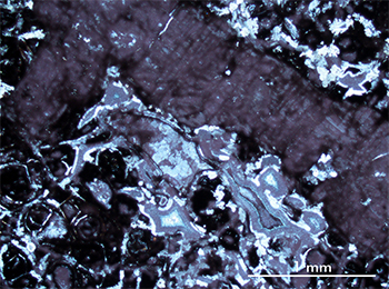
Figure 3a Photomicrograph of the quenched texture of the upper felsic volcanic unit near its lower contact (65.17 m), containing large feldspar phenocryst, elongate and distorted chlorite amygdales and perlitic texture in groundmass. (Cross-polarised light; SA Geodata rock sample 2332898; photo 415933)
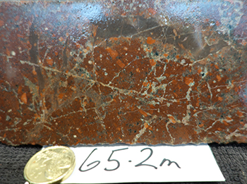
Figure 3b Small, grey, fine-grained sediment rafts in upper felsic volcanic unit, 65.2 m. (Photo 415934)
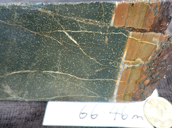
Figure 3c Contact between upper felsic volcanic unit (a narrow band of siltstone, right) and underlying upper mafic volcanic unit, 66.46 m. Note dacite within crack offsetting siltstone. (Photo 415935)
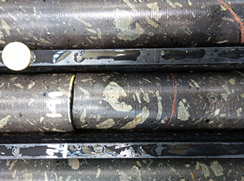
Figure 3d Plagioclase-rich basalt that includes abundant plagioclase megacrysts in upper mafic volcanic unit, 191 m. (Photo 415936)
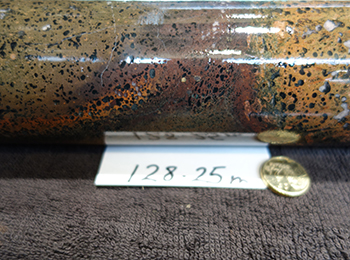
Figure 3e Curved boundary between zones of variable amygdale content in upper mafic volcanic unit, possibly representing pillow margins, 128.25 m. (Photo 415937)
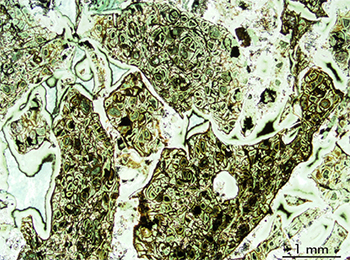
Figure 3f Photomicrograph of the partial jig-saw fit texture of many of the blocky to cuspate-shaped chlorite-replaced, perlitic basalt clasts in in situ hyaloclastite in the upper mafic volcanic unit, 264.68 m. (Plane-polarised light; sample 2333124; photo 415938)
The middle felsic volcanic unit is a homogeneous, coarse-grained, relatively crystal-rich (25–30 modal %) dacite. This unit contains abundant phenocrysts of plagioclase and minor replaced ferromagnesian phenocrysts with inconspicuous trace quartz phenocrysts. The groundmass has a micropoikilitic texture indicative of its original glassy texture. A faint flow texture in the groundmass is mainly observed close to the base. The upper contact of the unit is sharp and planar with tiny flames of the mafic material extending into the dacite at millimetre scale; and the lower contact with the lower mafic volcanic sequence is sharp. The base of the dacite is finely amygdaloidal (Fig. 4b), perlitic and spherulitic and contains slightly more conspicuous quartz as well as a small amount of alkali feldspar phenocrysts.
The lower mafic volcanic unit comprises a sequence of 15 flow units, ranging in thickness from almost 5 to 43 m, and all either aphyric (mainly upper half) or very sparsely plagioclase-phyric (Fig. 4c; mainly lower half). At the top of the highest basalt flow unit, the basalt has a quenched texture (Fig. 4d) and includes small (submillimetre) peperitic lenses of fine, quartz-bearing sediment that was unconsolidated when incorporated. Apart from these tiny sediment lenses, there is only a few metres of volcaniclastic sandstone in this thick sequence and one of these was found to contain conspicuous quartz and felsic lithic grains. The majority of the basalt flow units display the same systematic internal structure, which involves an amygdaloidal top, in places with flow-top breccia texture and minor incorporated sediment, and a massive, weakly amygdaloidal interior. Probable pillow margins and hyaloclastite (Fig. 4e) are less common than in the upper interval of mafic volcanic rocks in this drillhole and mainly occur in the first two flow units below the crystal-rich dacite.
The quartz- and feldspar-phyric unit is a massive, crystal-rich (~30 modal %) rhyolite (Fig. 4f), which is distinguished from all other logged units in the three MSDP holes by the presence of relatively abundant quartz phenocrysts (12–15 modal %). The feldspar phenocrysts include both alkali feldspar > plagioclase and there is a small number of highly altered probable ferromagnesian phenocrysts. There is sporadic development of a diffuse flow-banding and a 4 m wide band of brecciated rhyolite is either an autobreccia separating two units of the same rhyolite or, more likely, a zone of brittle deformation. The phenocrysts in the rhyolite are unbroken and the groundmass was originally glassy. Based on the observed core and thin section textures, the rhyolite is considered to be a coherent lava rather than a densely welded ignimbrite.
The lower felsic volcanic unit is an altered dacite which has a slightly oblique, possibly erosional, contact with the overlying rhyolite. This unit is finer grained than the overlying rhyolite and is also distinguished by a moderately crystal-rich (20–25 modal %), plagioclase-rich, quartz-poor composition, presence of ex-biotite phenocrysts and a lenticular groundmass foliation. The intense sericite–quartz–hematite alteration prevents distinction of this unit as a coherent lava or ignimbrite.
Figure 4 Gawler Range Volcanics, MSDP01.
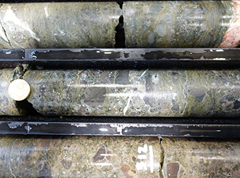
Figure 4a Polymictic pebbly volcaniclastic sandstone interval within upper mafic volcanic unit, showing the variety of clasts of basalt provenance, centred on 312.9 m. (Photo 415939)
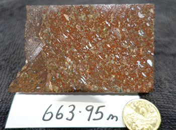
Figure 4b Small, white, quartz-filled, aligned amygdales near the base of middle felsic volcanic unit, 663.95 m. (Photo 415940)
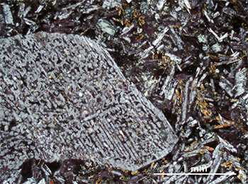
Figure 4c Photomicrograph of part of a sieve-textured large plagioclase phenocryst set in a fine-grained groundmass composed of bladed plagioclase laths, and more equant probable clinopyroxene and chlorite in lower mafic volcanic unit, 842.5 m. (Cross-polarised light; sample 2137626; photo 415941)
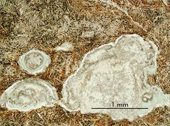
Figure 4d Photomicrograph of the quenched texture of the basalt in upper mafic volcanic unit (665.15 m), which contains abundant tiny plagioclase laths (some in radiating bunches, e.g. centre) and carbonate–quartz–chlorite amygdales. (Cross-polarised light; sample 2332889; photo 415942)
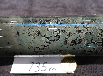
Figure 4e Ten centimetre long hyaloclastite in lower mafic volcanic unit, featuring jig-saw fit blocky to splintery clast texture, 735 m. (Photo 415943)
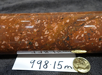
Figure 4f Evenly porphyritic texture of quartz- and feldspar-phyric volcanic unit containing pink plagioclase, smaller quartz and minor dark ferromagnesian minerals set in a fine-grained, slightly foliated groundmass, 998.15 m. (Photo 415944)
Depositional setting
The mafic volcanic units consist of thick (to ~300 m) sequences mainly composed of stacked basalt flows, which are characterised by amygdaloidal and in places brecciated tops, denser massive interiors, and in some cases brecciated bases. These features have been documented in younger basaltic sequences that straddle the subaerial/subaqueous divide, such as the Columbia River Basalt Group in the western USA (Riedel, Martin and Petcovic 2003), and are considered likely to occur in a subaerial setting, implying that at least the upper surface of many of the lava flows was emergent. The hyaloclastite and pillow textures are indicative of some flows being emplaced into water and the peperite has resulted where hot magma has come into contact with poorly or unconsolidated, usually wet sediment (Skilling et al. 2002), causing non-explosive magma fragmentation and fluidisation of sediment. Most of the occurrences of polymictic volcaniclastic breccia within the mafic volcanic sequences form relatively thick (to 15 m) horizons, which are mainly massive and non-graded. However, some of the sandstone beds at the top of these breccia horizons are thinly bedded, diffusely laminated, better sorted and normally graded, features which suggest deposition of reworked basaltic debris in a standing body of water.
The felsic volcanic units are mainly thick, compositionally and texturally relatively homogeneous, and are interpreted as predominantly coherent. The unit contacts, in particular the upper contact, are critical for discriminating whether the felsic units were emplaced as lava flows or as high-level sills. The upper contact of the upper felsic unit is not preserved, but the base is brecciated, finely amygdaloidal and contains peperitic rafts of fine sediment. At the upper contact of the middle felsic unit, tiny flames of sediment that is part of the overlying basalt sequence penetrate into the top of the dacite. The base of the middle felsic unit is finely amygdaloidal and perlitic, with a sharp, planar lower contact. The quartz- and feldspar-phyric volcanic unit has a sharp upper contact with the lower mafic volcanic unit, and its contact with the underlying lower felsic volcanic unit is possibly erosional. In all of the above situations, the observed contacts are inconclusive in terms of emplacement as lavas or sills; however, the occurrence of basal peperitic texture (upper unit) and sediment flames (middle felsic volcanic unit) is evidence that the felsic units are essentially synchronous with eruption and emplacement of the basalt sequence.
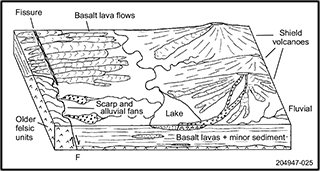
Figure 5 Schematic possible paleolandscape envisaged during eruption of the two units of mafic volcanic rocks in the Six Mile Hill area.
The interpreted depositional environment for the Gawler Range Volcanics at Six Mile Hill (Fig. 5) is a broadly low-relief depositional basin, which fluctuated between subaerial and subaqueous settings, the latter occurring after basalt lava flows blocked watercourses to form lakes of moderate depth and probably substantial size. The most likely basalt sources in a relatively large lava field are either fissures, which have been documented in both large and small continental flood basalt provinces (White et al. 2009), or shield volcanoes of the type documented in the eastern Snake River Plain (15–20 km-diameter; Shervais et al. 2005) from which lava has been documented as flowing up to 60 km from vent. Since the nature and position of the source vent(s) for the basalt lavas in the Six Mile Hill area is unknown, both fissures and low-angle shield volcanoes are included as possibilities in Figure 5.
During the episodes of mafic volcanism, basalt extrusion appears to have been greater (larger volumes and/or higher extrusion rates) at Six Mile Hill than at Roopena, leading to a thick sequence of stacked lava flows in which there was little opportunity for reworking between successive flows. It is likely that the area was either in a wider, less confined part of the basin compared with Roopena and possibly farther from basin margins and/or uplifted older felsic Gawler Range Volcanics rocks, based on the small amount of felsic material incorporated into the sedimentary facies within the basalt intervals. A hiatus in basalt eruption units is marked by emplacement of the middle felsic volcanic unit as either large lava flows or sills. If either the middle or upper felsic units were emplaced as lavas, their thickness (up to ~300 m) suggests they probably had considerable extent, possibly comparable with that of the three upper Gawler Range Volcanics units, which have been interpreted as extensive lavas (Allen et al. 2003).
References
Allen SR, Simpson C, McPhie J and Daly S 2003. Stratigraphy, distribution and geochemistry of widespread volcanic units in the Mesoproterozoic Gawler Range Volcanics, South Australia. Australian Journal of Earth Sciences 50:97–112.
Crone AJ, De Martini PM, Machette MN, Okumura K and Prescott JR 2003. Paleoseismicity of two historically quiescent faults in Australia: implications for fault behaviour in stable continental regions. Bulletin of the Seismological Society of America 93:1,913–1,934.
Riedel SP, Martin BS and Petcovic HL 2003. The Columbia River flood basalts and the Yakima fold belt. In TE Swanson ed., Western Cordillera and adjacent areas, Field Guide 4. Geological Society of America, Boulder, Colorado, pp. 87–106.
Shervais JW, Kauffman JD, Gillerman VS, Othberg KL, Vetter SK, Hobson VR, Zarnetske M, Cooke MF, Matthews SH and Hanan BB 2005. Basaltic volcanism of the central and western Snake River Plain: a guide to field relations between Twin Falls and Mountain Home, Idaho. In J Pederson and CM Dehler eds, Interior Western United States, Field Guide 6. Geological Society of America, Boulder, Colorado, pp. 1–26.
Skilling IP, White JDL and McPhie J 2002. Peperite: a review of magma-sediment mingling. Journal of Volcanology and Geothermal Research 114:1–17.
White JDL, Bryan SE, Ross PS, Self S and Thordarson T 2009. Physical volcanology of continental large igneous provinces: update and review. In J Pederson, and CM Dehler eds, Studies in volcanology: the legacy of George Walker, Special Publications of the International Association of Volcanology and Chemistry of the Earth's Interior 2. Geological Society, London.


