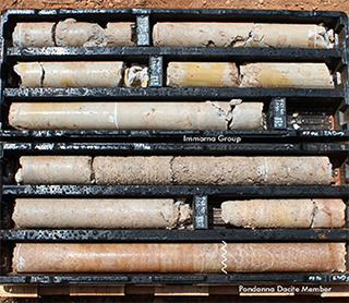
Mario Werner, Carmen Krapf, Stacey Curtis, Mark Pawley and Adrian Fabris
Geological Survey of South Australia, Department of the Premier and Cabinet
Download this article as a PDF (26 MB); cite as MESA Journal 86, pages 14–29
Introduction
Figure 1 Outcropping geology of northern Eyre Peninsula showing the location of the Peltabinna Special Map.
The Peltabinna map sheet area is situated on the northern Eyre Peninsula about 80 km north of Wudinna and forms part of the southern Gawler Ranges (Fig. 1). This region is highly prospective for mineral deposits that formed in the earliest Mesoproterozoic during a major tectono-magmatic event within the Gawler Craton. This c. 1.6 Ga event is manifested by the extrusion of the voluminous Gawler Range Volcanics (GRV), and the extensive intrusion of Hiltaba Suite granites and smaller volumes of intermediate to mafic rocks (Allen et al. 2003; Stewart and Foden 2003). Together these magmatic rocks constitute the Gawler Siliceous Large Igneous Province (SLIP; Allen et al. 2008; Agangi, Kamenetsky and McPhie 2012). GRV–Hiltaba magmatism (c. 1600–1570 Ma) was broadly contemporaneous with localised and episodic deformation and metamorphism in the Gawler Craton (Wartakan–Kararan tectonic event/orogeny), with tectonism preceding (as early as 1640 Ma?) and succeeding (as late as 1530 Ma?) this magmatic phase (Ferris, Schwarz and Heithersay 2002; Hand, Reid and Jagodzinski 2007; Stewart and Betts 2010; Reid and Hand 2012).
Figure 2 Location of the Peltabinna map sheet area within the Central Gawler Gold Province showing nearby mineral deposits and prospects.
The Mineral System Drilling Program (MSDP) was instigated in an attempt to identify regional-scale vectors to mineralisation and map alteration and geochemical footprints under cover (Fabris et al. 2017). MSDP focused on the southern Gawler Ranges margin and drilling at Peltabinna investigated potential epithermal Au–Ag mineralisation along the NW-trending Progress–Eurilla fault zone (Fig. 2). These prominent structures are characterised by moderate to strong demagnetisation, show evidence of syn-GRV and pre-Hiltaba granite intrusion tectonic activity, and were interpreted as potential splays of the Yarlbrinda Shear Zone (Fabris et al. 2017).
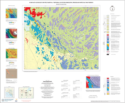
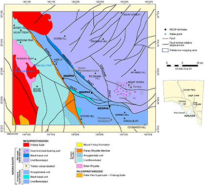
Detailed geological mapping was carried out alongside the MSDP, providing a regional geological context in which the stratigraphy, alteration and mineralisation of the drilling could be interpreted. Outcrop, structural and regolith mapping was assisted and complemented by interpretation of remote-sensing and orthophoto imagery, digital elevation model, total magnetic intensity (TMI) and gravity data, as well as thin section petrography and geochemistry. The recent Peltabinna releases are products of the second MSDP phase and include the 1:75,000 scale surface geology map (Werner et al. 2017b; Fig. 3), the interpreted Proterozoic solid geology map (Pawley et al. 2017) and the accompanying explanatory notes (Werner et al. 2017c).
This article provides a summary of the key outcomes and geological highlights from the Peltabinna mapping, including:
- characterisation of the effusive part of the GRV
- recognition and interpretation of new volcaniclastic stratigraphic units within the upper GRV lavas, with implications for hydrothermal fluid pathways, and potential epithermal mineralisation
- characterisation of Hiltaba Suite granites and discovery of greisen alteration and local examples of presence of cassiterite and sulfide minerals in these rocks
- new constraints on the timing of magmatism and deformation during the Mesoproterozoic
- new insights into the area’s Cenozoic paleodrainage system.
Geological overview
Peltabinna is located at the southwestern margin of the Gawler Ranges Volcanic Province. Paleoproterozoic basement belongs to the Nuyts Domain of the Gawler Craton and includes variably deformed granitoids of the c. 1745–1700 Ma Peter Pan Supersuite and the c. 1690–1670 Ma Tunkillia Suite. This basement is overlain by the early Mesoproterozoic GRV and Cenozoic sediments. Granites of the Hiltaba Suite intruded both the Paleoproterozoic basement and the Mesoproterozoic GRV succession.
The Peltabinna area is also located within the Central Gawler Gold Province, which flanks the southwestern margin of the Gawler Ranges (Fig. 2). Mineralisation in the vicinity of Peltabinna is linked to GRV–Hiltaba magmatism, including the gold-bearing vein deposits at Tunkillia, Nuckulla Hill, Toondulya and Barns (Drown 2003; Ferris and Schwarz 2003; Ferris and Wilson 2004; Fraser et al. 2007). To the southeast of Peltabinna, epithermal Ag–Pb–Zn mineralisation at Paris and Menninnie Dam is also related to felsic GRV–Hiltaba Suite magmatism causing intensive brecciation and acting as drivers of mineralising hydrothermal systems (Roache, Allen and McPhie 2000).
New insights into the geology
Siliceous lavas of the GRV
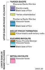
The GRV are a succession of laterally extensive siliceous lava flows comprising on Peltabinna the Bittali and Eucarro rhyolites as well as the Pondanna Dacite and Moonaree Dacite members of the Yardea Dacite (Fig. 4).
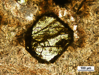
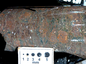
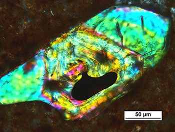
The individual lava flows typically show a distinct vertical zonation consistent with cooling and degassing as single effusive emplacement units (Allen et al. 2003). Basal sections are commonly dark grey to black and possess a crypto- to microcrystalline groundmass indicating that they were originally glassy and cooled rapidly. These basal parts usually represent the least altered parts of the lava flows with ferromagnesian phenocrysts such as pyroxene often preserved in a remarkably fresh state (Fig. 5a). Some basal sections contain rare volcaniclastic facies. For example, the base of the Pondanna Dacite Member in drillhole MSDP07 (SA Geodata drillhole number 288773) is formed by a welded autobreccia (Fig. 5b), which grades upward into streaky-textured and flow-banded dacite and then into a coherent dacite containing flattened volcanic clasts with wispy margins that have the appearance of compacted pumice.
Figure 5 Basal lava flow sections of the GRV, Peltabinna.
Figure 5a Fresh clinopyroxene phenocryst, lower part of Eucarro Rhyolite in MSDP05. (Plane-polarised light; SA Geodata rock sample 2137855; photo 416270)
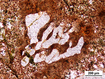
The middle portions of the lava flows are typically composed of reddish-brown porphyritic rhyolite or dacite. Phenocrysts are dominated by feldspars with plagioclase being usually more abundant than alkali-feldspar. Quartz phenocrysts, which are typically rounded and embayed, occur in substantial amounts in the Bittali Rhyolite and in the Paney Rhyolite Member of the Eucarro Rhyolite, but only in trace amounts in the other lava flow units. Feldspar phenocrysts are present as euhedral–subhedral crystals as well as strongly resorbed, skeletal or spongy-textured crystals (Fig. 6a). Ferromagnesian phenocrysts are mainly represented by clinopyroxene, which are commonly altered to amphibole and/or chlorite. Common accessories are titanomagnetite, apatite and zircon, which often occur in glomeroporphyritic crystal clusters together with pyroxene. Some zircons show complex internal structures recording multi-stage growth and resorption histories indicating complex and dynamic magma chamber processes (Fig. 6b).
Figure 6 Magmatic minerals within GRV lavas, Peltabinna.
Figure 6a Photomicrograph of resorbed skeletal feldspar phenocryst, Pondanna Dacite Member. (Plane-polarised light; sample 2138774; photo 416272)
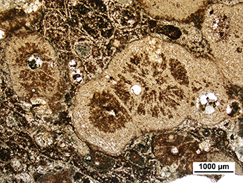
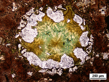
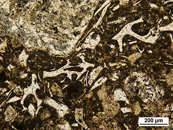
Groundmass textures range from spherulitic and micropoikilitic in the lower and upper parts to microgranular and granophyric in the central interiors of the lava flows. Relicts of perlitic fractures occurring within spherulitic portions indicate a formerly glassy groundmass due to rapid cooling (Fig. 7a). The granophyric parts of the lava flows are often columnar jointed in outcrop and display vermicular quartz–feldspar granophyre in thin sections, indicating that the interiors of the lava flows were well insulated and cooled comparatively slowly. The upper parts of the lava flows are commonly amygdaloidal with quartz, chlorite, calcite and fluorite occurring as vesicle fills (Fig. 7b).
Figure 7 Groundmass textures within GRV lava flows, Peltabinna.
Figure 7a Photomicrograph of coalesced spherulites and perlitic fractures in devitrified groundmass, upper part of the of the Eucarro Rhyolite. (Plane-polarised light; sample 2136039; photo 416274)
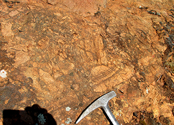
The quartz- and feldspar-phyric Paney Rhyolite Member forms a distinct unit at the top of the Eucarro Rhyolite (Fig. 4). Our recent mapping has shown that this unit can be traced up to the Mount Friday area, increasing the known extent of this unit by about 30 km. A locally preserved autoclastic breccia carapace (Fig. 8) is strongly silica-cemented indicating that epithermal fluid flow focused along this permeable volcaniclastic horizon.
Our new detailed mapping and reappraisal of these exposed GRV lithologies and the local stratigraphy became an important tool in the interpretation of the MSDP drillholes on Peltabinna and will provide an essential dataset for future exploration activities in this area.
Figure 8 Clast-supported autobreccia at the top of the Paney Rhyolite Member, Peltabinna. (SA Geodata site number 2012069; photo 416269)
Volcaniclastic–sedimentary deposits within the upper GRV
Mount Friday Formation
The Mount Friday Formation is a newly defined stratigraphic unit within the upper GRV and consists of volcaniclastic deposits occurring between the Eucarro Rhyolite and the Yardea Dacite (Werner et al. 2017c; Fig. 4). These rocks were first discovered during the MSDP mapping in the Mount Friday area, where they are exposed within a northwest-trending outcrop strip along the contact between the Paney Rhyolite and the Pondanna Dacite members, separated by the Eurilla Fault (Fig. 9). The Mount Friday Formation was also intersected in MSDP05 (drillhole 288771) and MSDP07. Stratigraphic correlatives are the Mount Double Ignimbrite near Paney (Allen et al. 2003) and unnamed volcaniclastic–sedimentary rocks in the Nonning – Mount Ive area (Crooks 1996; Allen et al. 2008). These volcaniclastic units form a lithologically distinct and regionally extensive marker horizon within the upper GRV.
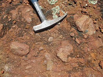
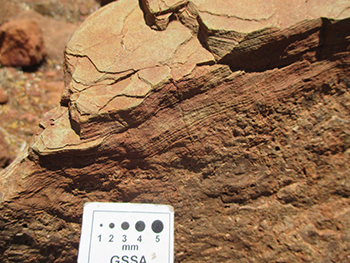
In outcrop the Mount Friday Formation overlies coherent and autobrecciated facies of the Paney Rhyolite Member and consists of poorly sorted, matrix-supported volcanic lithic breccias and conglomerates grading into clast-bearing volcanic mudstones (Fig. 10a). Locally these rocks contain intercalations of better sorted, clast-supported volcanic conglomerates, volcanic sandstones and rare laminated siltstones (Fig. 10b). Lithic clasts are almost entirely derived from the Paney Rhyolite Member. The matrix is mainly composed of originally glassy, now devitrified and recrystallised, rhyolite detritus. Some samples contain bubble wall and junction shards as minor pyroclastic components.
Figure 10 Outcropping Mount Friday Formation, Peltabinna.
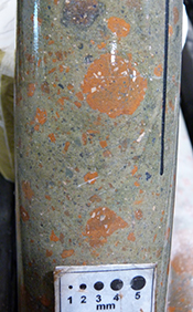
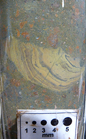
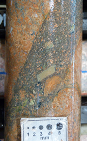
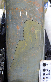
In MSDP05 and MSDP07 the up to 90 m thick Mount Friday Formation either overlies or is intercalated with vesicular Eucarro Rhyolite and consists predominantly of poorly sorted, matrix-supported volcanic breccias and intercalated clast-supported conglomerates, sandstones and mudstones (Fig. 11a). Some breccias contain intraformational mudstone rip-up clasts in addition to volcanic lithic clasts (Fig. 11b). Volcanogenic sedimentary material also forms the peperitic matrix of autoclastic rhyolite and clastic dykes at the top of coherent rhyolite (Fig. 11c). Some of the mudstones show soft-sediment deformation structures such as injection into overlying deposits (Fig. 11d). Some tuffaceous deposits contain glass shards and pumice fragments as pyroclastic components (Fig. 12).
Figure 11 Mount Friday Formation in drill core.
Figure 11a Matrix-supported volcanic breccia with reddish-brown rhyolite clasts, MSDP07, 168 m. (Photo 416278)
Figure 11b Intraformational clast of laminated mudstone within matrix-supported volcanic breccia–sandstone, MSDP07, 159.5 m. (Photo 416279)
Figure 11c Volcanic breccia–sandstone forming clastic dyke within fractured rhyolite, MSDP05, 200.5 m. (Photo 416280)
Figure 12 Photomicrograph of highly vesicular volcanic glass fragments within tuffaceous sandstone of the Mount Friday Formation, MSDP05, 184.4 m. (Plane-polarised light, sample 2137848, photo 416282)
Soft-sediment deformation features show that the Mount Friday Formation is mainly composed of water-lain deposits, which mainly represent resedimented autoclastic volcanic material. The matrix-supported volcanic breccias to mudstones were deposited by debris and mudflows, whereas better sorted volcanic conglomerates and sandstones probably represent hyperconcentrated flow deposits (Pierson 2005). Episodic rainfall probably triggered reworking of autoclastic volcanics, leading to deposition of coarse-grained material from high-concentration sediment gravity flows (Pierson et al. 2013). Between episodes of high-energy mass-flow deposition, fine-grained sediments were deposited in small lacustrine water bodies. These low-energy deposits were commonly reworked during subsequent high-energy flow events as evidenced in the numerous occurrences of intraformational rip-up clasts. Interbedding and mingling of volcanogenic sedimentary deposits with coherent and autoclastic volcanics show that sedimentation was locally contemporaneous with effusive volcanism. Glass shards and pumice clasts indicate that sedimentation and lava extrusion was also accompanied by explosive volcanism.
Parts of the Mount Friday Formation are variably silicified, hematised and/or overprinted by sericite and chlorite alteration, especially near faults. Quartz–pyrite veining within intercalated Mount Friday Formation and vesicular Eucarro Rhyolite is locally associated with geochemical anomalies for Au, Ag, Cu, Pb, Mo, Bi, As, Sb, Cs and S, which is typical of epithermal alteration systems (Fabris 2017; Fabris et al. 2017; Werner et al. 2017a, c). This shows that permeable volcaniclastic rocks within the upper GRV have provided pathways for hydrothermal fluids, and thus have potential to host mineralisation such as epithermal Au–Ag–Cu–Pb–Zn deposits.
Yartoo volcaniclastics
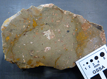
The ‘Yartoo volcaniclastics’ are a new stratigraphic subunit of the Yardea Dacite (Werner et al. 2017c). They are poorly exposed in the vicinity of the Yartoo Homestead along a northwest-trending vein quartz zone, which marks the surface trace of the Progress Fault (Fig. 9). The Yartoo volcaniclastics consist of poorly sorted, matrix-supported volcanic breccias (Fig. 13a) containing dispersed and variably altered feldspar crystals and vitriclasts. Volcanic sandstones and siltstones are minor lithologies.
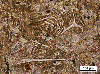
Alkali-feldspar crystals show patchy sericite–kaolinite–hematite alteration, whereas plagioclase crystals are intensively hematite stained. Dark-brown ferruginised ferromagnesian phenocrysts probably represent pyroxene. Volcanic lithic clasts are probably derived from the underlying Pondanna Dacite Member. Some vitriclasts show flow foliation or perlite cracks in thin section. The matrix of these volcaniclastic rocks contains devitrified and recrystallised bubble wall and junction shards showing platy, spiky, y-shaped, cuspate, crescentic or circular forms (Fig. 13b) and are clearly of pyroclastic origin. Some samples contain dark-brown wavy clay laminae in the matrix.
These rocks may represent primary pyroclastic or resedimented volcaniclastic deposits. The poorly sorted, unstratified character of these rocks indicates deposition via mass flow process, e.g. pyroclastic flow or alluvial–fluvial debris-mudflow. The presence of clay laminae favours interpretation as water-lain deposits, e.g. fluvially reworked volcanic material.
As the Yartoo volcaniclastics are lithologically similar to the Mount Friday Formation deposits they may have also channelised hydrothermal fluids locally. Thus, exploration within the upper GRV should consider this stratigraphic level as another prospective target horizon.
Figure 13 Yartoo volcaniclastics, Peltabinna.
Figure 13a Cut section showing white alkali-feldspar and yellowish plagioclase crystals dispersed within a bluish-grey matrix. (Sample 11070; photo 416283)
Hiltaba Suite granites and greisen alteration
Leucocratic biotite granites of the Hiltaba Suite occur in the western part of Peltabinna (Figs 3, 9). They commonly contain miarolitic cavities filled with quartz, feldspar, fluorite and hematite. In thin sections these granites typically display micrographic quartz–feldspar intergrowths. Extensive outcrops to the north of Mount Friday represent the southeastern part of the Hiltaba pluton (Stewart and Foden 2003), which forms a southeast-trending, about 30 km long and up to 7 km wide intrusion emplaced within the upper GRV. Granite hills to the southwest of Perening Bluff form part of the newly named Mulandilla pluton (Werner et al. 2017c). Granite outcrops near Narlaby Well represent the northeastern margin of the newly named Narlaby Well pluton, a broadly circular intrusion with a diameter of about 4–5 km. MSDP07 intersected Hiltaba Suite granite in intrusive contact with the Eucarro Rhyolite at the bottom of the hole (Fabris et al. 2017). Primary intrusive contacts with effusive GRV units show that these granites were emplaced into high crustal levels, probably as sill-like bodies.
Hiltaba Suite granites from Peltabinna are characterised by high silica (74.6–77.5 wt% SiO2) and potassium (5.2–5.9 wt% K2O) contents. Subtle geochemical differences distinguish individual granite plutons. Granite of the Mulandilla pluton shows Fe, Ti, Nb and Zr enrichments in comparison with the Hiltaba pluton. Narlaby Well granite is depleted in Ca and Cs, and enriched in K, Rb, Ba, Th and light rare earth elements (REE). The Hiltaba Suite granite from MSDP07 is in comparison to the other Hiltaba Suite granites from Peltabinna enriched in Ca, Na, Rb, Cs, Nb, Th, U and heavy REE, and depleted in Sr, Ba, and Eu (Werner et al. 2017c).
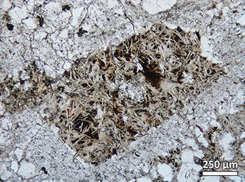
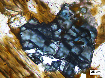
Greisen-style alteration and low-grade mineralisation were discovered north of Mount Friday within granite of the Hiltaba pluton where it contains an east-trending, schlieren-like zone in which the host granite is altered to a dark-grey, quartz-rich, hematitic greisen. Thin sections show that this greisen is mainly composed of quartz and white mica, with smaller amounts of hematite and fluorite, and some altered magmatic biotite. Phyllic alteration pseudomorphically replaced magmatic feldspars with white mica (phengitic muscovite) intergrown with quartz and hematite (Fig. 14a). Deep-blue niobian anatase formed in response to magnetite and biotite alteration (Fig. 14b). Reflected light and secondary electron microscopy confirmed the presence of chalcopyrite, cassiterite, sphalerite and galena.
Geochemical comparison of the greisen with nearby Hiltaba Suite granites shows that the alteration led to an increase in Si, Fe, Mn and Cs. Potassium is clearly depleted but still present in significant amounts, mainly within newly formed white mica and relict biotite. Sodium was almost completely removed, which is reflected in the absence of a sodium-bearing mineral phase. The greisen is also enriched in Sn, Cu, Zn, Pb, Bi, As and Sb due to the presence of cassiterite and sulfide minerals. Greisenisation and associated mineralisation (Au–Sn) occurs also at Glenloth and Earea Dam as well as in the Tanner Dam area to the north and east of Peltabinna (Marinelli and Mackee 1990). This shows that the roof zones of shallow crustal Hiltaba Suite granite plutons and the immediately overlying GRV are prospective for mineral deposits associated with greisen alteration.
Figure 14 Greisen-altered Hiltaba Suite granite, Hiltaba pluton, Peltabinna.
Figure 14a Photomicrograph of feldspar crystal replaced by white mica, quartz and hematite. (Plane-polarised light; sample 2136021; photo 416285)
Timing of deformation in relation to GRV–Hiltaba Suite emplacement
Cross-cutting relationships derived from field observations and interpretation of geophysical data reveal a chronology of tectonism and emplacement of magmatic rocks during and after the c. 1.6 Ga GRV–Hiltaba event. Three stages of deformation can be recognised on Peltabinna:
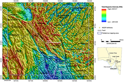
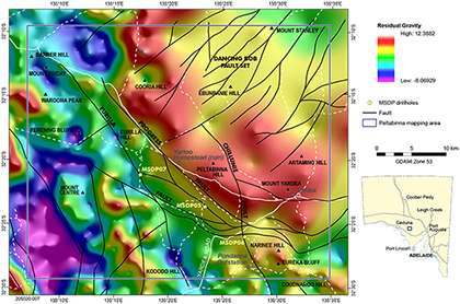
- Field mapping has shown that the upper GRV was affected by brittle faulting along the northwest-trending Progress–Eurilla fault zone (Werner et al. 2017c; Figs 15, 16). In TMI images, the Eurilla Fault is a prominent linear demagnetisation feature and field observations indicate northeast-side down movement along this fault. The Progress Fault forms a subtler, less intensively demagnetised structure, yet it corresponds to a sharp gradient on residual gravity images, with much higher densities to the northeast (Fig. 16). A northwest-trending breccia and vein quartz zone near Yartoo Homestead probably forms the surface expression of this fault.
TMI images indicate that the Progress–Eurilla fault zone is truncated by the Hiltaba pluton, which intruded into the upper GRV. This shows that this fault zone was tectonically active during and after eruption of the upper GRV and may have initiated as synvolcanic growth faults. Movement along these faults probably ceased before the final emplacement of the Hiltaba pluton. However, the northwest-elongate Hiltaba pluton appears to be the continuation of the Progress–Eurilla fault zone indicating that magma ascent and emplacement of this granite was facilitated and strongly influenced by these structures. Furthermore, these faults also acted as fluid flow conduits as evidenced in the epithermal alteration and veining nearby. Hiltaba Suite granites probably were the thermal drivers for hydrothermal fluid flow within these structures (Fabris 2017; Fabris et al. 2017). - The second stage of deformation is restricted to the area northeast of the Progress–Eurilla fault zone, corresponding to the outcrop area of the Moonaree Dacite Member. This area is characterised by a prominent set of northeast-striking, curviplanar anastomosing faults that do not appear to extend into the underlying units of the upper GRV (Figs 9, 15, 16). These faults, referred to as the Dancing Bob fault set (Werner et al. 2017c), have a relatively uniform orientation, which is independent of the orientation of the volcanic layering, suggesting they are later structures and are not related to volcanic processes. Based on aeromagnetic interpretation, it is possible that one of the northeast-striking structures cuts the Hiltaba granite pluton in the northwest corner of Peltabinna. This relationship supports the interpretation that these structures are younger than the granite intrusion. The dominance of the Dancing Bob fault set in the uppermost unit of the GRV may reflect the partitioning of later external stresses into more competent, relatively homogenous rocks.
- The youngest structures form the north-northwest-striking Chillunie fault set (Werner et al. 2017c) that appears to overprint and sinistrally offset faults of the Dancing Bob fault system. Based on changes in magnetic character and drillhole data near MSDP06, the main Chillunie Fault west of Yardea Homestead appears to be a normal fault with east-side-down movement.
The Progress Paleochannel system: new insights into Cenozoic paleodrainage
The separation of Australia from Antarctica in the Paleo-Neogene led to marine transgression into several basins in the southern part of South Australia, including the Eucla Basin (Alley and Lindsay 1995; Sheard 2007). As Australia gradually drifted northwards, the climate warmed and rainfall increased, promoting weathering and fluvial erosion leading to the formation of paleochannels, including the Narlaby Paleochannel system on the northwestern margin of the Eucla Basin (Hou et al. 2012), located in the west of Peltabinna. The paleochannels were dominated by sand during the Eocene, but become progressively dominated by silt to clay in the Miocene (Benbow, Lindsay and Alley 1995; Hou et al. 2000; Hou 2004). During the Pliocene the climate became more arid, causing these river systems to cease flowing (Alley and Lindsay 1995). By mid to late Pleistocene, strings of ephemeral playas and small clay pans marked the original fluvial traces of the near totally sediment infilled paleovalleys (Hou et al. 2000; Hou 2004).
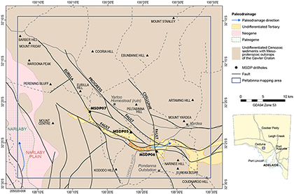
Sediments of inferred Paleo-Neogene age were intersected in all three MSDP drillholes (MSDP05–07) on Peltabinna. These clastic fluvial deposits of the newly named Progress Paleochannel (Fig. 17) form part of the northeastern margin of the Eucla Basin. This paleochannel has previously been mapped as a paleodrainage direction (Hou et al. 2012), but no information about the channel fill was available prior to the MSDP. The Progress Paleochannel traversed and drained the central part of Peltabinna in an easterly direction towards a precursor of Lake Gairdner and the course of this paleochannel was strongly influenced by the Progress–Eurilla fault system (Fig. 17). The up to 50 m thick channel-fill succession is characterised by coarse-grained conglomerate–sandstone facies representing fluvial channel deposits and fine-grained mudstone–sandstone facies representing floodplain and lacustrine deposits (Fig. 18).
These valley-infill sediments may have remained active exit conduits for groundwater since burial and therefore may be enriched with trace elements like K, V, Th and U (Sheard 2007). The paleochannels have been explored and remain exploration targets for sandstone-hosted uranium deposits (Binks, Hooper and Owen 1984; Hewitt and Caon 2011; Domnick et al. 2018).
Figure 17 Paleodrainage map of Peltabinna showing the Narlaby Paleochannel system in the west and the newly mapped Progress Paleochannel in the central-southern part of the map sheet.
Future releases
The Peltabinna 1:75,000 surface geology map, 1:75,000 interpreted bedrock geology map and explanatory notes are the second set of products to be released from the MSDP. The maps and explanatory notes for the Mount Double MSDP drilling area, also on the southwestern margin of the Gawler Ranges, will be released in mid-2018.
Acknowledgements
We thank Luke Tylkowski for providing logistical support during the field mapping program. Access to Hiltaba Station was granted by the Nature Foundation, Sandy Morris provided access to Yardea Station and the Department of Environment, Water and Natural Resources granted access to the Gawler Ranges National Park. Ben Wade (Adelaide Microscopy) provided assistance with scanning electron microscope analysis and Georgina Gordon with HyLoggerTM and Gold Sniffer analyses.
References
Agangi A, Kamenetsky VS and McPhie J 2012. Evolution and emplacement of high fluorine rhyolites in the Mesoproterozoic Gawler Silicic Large Igneous Province, South Australia. Precambrian Research 208–211:124–144.
Allen SR, McPhie J, Ferris G and Simpson C 2008. Evolution and architecture of a large felsic igneous province in western Laurentia: The 1.6 Ga Gawler Range Volcanics, South Australia. Journal of Volcanology and Geothermal Research 172(1–2):132–147.
Allen SR, Simpson CJ, McPhie J and Daly SJ 2003. Stratigraphy, distribution and geochemistry of widespread felsic volcanic units in the Mesoproterozoic Gawler Range Volcanics, South Australia. Australian Journal of Earth Sciences 50(1):97–112.
Domnick U, Cook NJ, Bluck R, Brown C and Ciobanu CL 2018. Petrography and geochemistry of granitoids from the Samphire pluton, South Australia: implications for uranium mineralisation in overlying sediments. Lithos 300–301:1–19.
Fabris A 2017. Geological outcomes of the Mineral Systems Drilling Program along the southern Gawler Ranges. MESA Journal 85:12–23. Department of the Premier and Cabinet, South Australia, Adelaide.
Ferris GM, Schwarz MP and Heithersay P 2002. The geological framework, distribution and controls of Fe-oxide Cu-Au mineralisation in the Gawler Craton, South Australia. Part I – Geological and tectonic framework. In TM Porter ed, Hydrothermal iron oxide copper-gold and related deposits: a global perspective, vol. 2. PGC Publishing, Adelaide, pp. 9–31.
Fraser GL, Skirrow RG, Schmidt-Mumm A and Holm O 2007. Mesoproterozoic gold in the Central Gawler Craton, South Australia: geology, alteration, fluids, and timing. Economic Geology 102(8):1511–1539.
Hand M, Reid A and Jagodzinski L 2007. Tectonic framework and evolution of the Gawler Craton, southern Australia. Economic Geology 102(8):1377–1395.
Pierson TC 2005. Hyperconcentrated flow – transitional process between water flow and debris flow. In M Jakob and O Hungr eds, Debris-flow hazards and related phenomena. Springer/Praxis, Chichester, UK, pp. 159–202.
Pierson TC, Major JJ, Amigo Á and Moreno H 2013. Acute sedimentation response to rainfall following the explosive phase of the 2008–2009 eruption of Chaitén volcano, Chile. Bulletin of Volcanology 75:723.
Reid A and Hand M 2012. Mesoarchaean to Mesoproterozoic evolution of the southern Gawler Craton, South Australia. Episodes 35:216–225.
Roache MW, Allen SR and McPhie J 2000. Surface and subsurface facies architecture of a small hydroexplosive, rhyolitic centre in the Mesoproterozoic Gawler Range Volcanics, South Australia. Journal of Volcanology and Geothermal Research 104:237–259.
Stewart JR and Betts PG 2010. Late Paleo-Mesoproterozoic plate margin deformation in the southern Gawler Craton: insights from structural and aeromagnetic analysis. Precambrian Research 177(1–2):55–72.


