Stacey Curtis, Claire Wade and Anthony Reid
Geological Survey of South Australia, Department for Energy and Mining
Download this article as a PDF (4.7 MB); cite as MESA Journal 87, pages 28–33
Published August 2018
Introduction
Figure 1 (a) Surface geology (adapted from Krapf et al. 2016) and (b) aeromagnetic expression (TMI 1VD) of the Roopena-Myall Creek area, showing the preserved outcrop and subsurface extent of the Roopena Basin between the Roopena and Wizzo Well faults. Reprinted from Curtis, Wade and Reid (2018; fig. 2) with added locality map.
Iron oxide – copper–gold (IOCG) mineralisation within the eastern Gawler Craton formed synchronous with emplacement of a silicic large igneous province – the Mesoproterozoic (1595–1575 Ma) Gawler Range Volcanics and Hiltaba Suite. A causal link between the hydrothermal breccia systems and this high temperature mafic and felsic magmatism in the Olympic Cu–Au Province has been demonstrated (e.g. Skirrow et al. 2007). However, the two largest currently mined IOCG deposits, Olympic Dam and Prominent Hill, are both also spatially associated with sedimentary rocks deposited synchronous with volcanism (Belperio, Flint and Freeman 2007; Bull et al. 2015; McPhie et al. 2016). It has been suggested that the presence of an active sedimentary basin may have also been significant in the formation of IOCG mineralisation (McPhie et al. 2011) by potentially providing the saline groundwaters that are a key component of the fluid-mixing model for the formation of the Olympic Dam orebody (Haynes et al. 1995).
One of the best preserved sedimentary successions to have formed during this early Mesoproterozoic event occurs on northern Eyre Peninsula. The volcano-sedimentary succession within the Roopena Basin (Fig. 1) provides a unique window into the types of sedimentary processes that were operating during this major igneous and metallogenic event. In addition, the Roopena Basin remains an exploration target for IOCG-type deposits.
Recent work by the Geological Survey of South Australia has redefined the stratigraphy of the Roopena Basin, which was previously considered to be part of the Corunna Conglomerate (Daly 1993). The aim of the work program was to determine the extent, architecture and sedimentological and volcanic evolution of the Roopena Basin. Work completed included re-logging of available drill core, including drill core obtained from the recent Mineral Systems Drilling Program (Fabris et al. 2017), remapping the exposed portions of the Roopena Basin in the vicinity of Roopena Homestead, and detrital zircon geochronology.
The first results of this work program were published in a departmental report book, which presented detailed core logging and lithostratigraphic correlation within the basin (McAvaney and Wade 2015). Recently, the final interpretations and broader regional implications from the work were published as an Open Access article in the Australian Journal of Earth Sciences (Curtis, Wade and Reid 2018). Here we summarise the significant aspects of the work as an overview of the geology of the Roopena Basin.
Roopena Basin geology
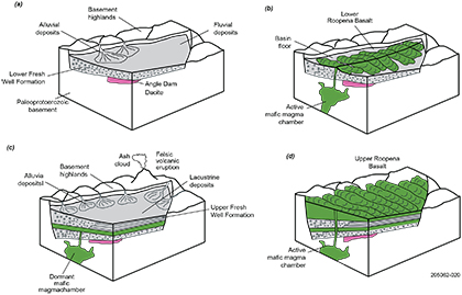
The Roopena Basin is a north–south-trending basin ~6 km wide, bound by the Roopena and Wizzo Well faults (Fig. 1). It has a preserved extent of 75 km2 based on outcrop and intersections in drillholes; however the original extent of the basin may have been significantly larger, given the thickness of the preserved volcano-sedimentary succession is up to 330 m. The basin contains three units of the lower Gawler Range Volcanics: the Angle Dam Dacite (see Footnote 1); upper and lower Fresh Well Formation; and upper and lower Roopena Basalt (Fig. 2). The evolution of the basin consisted of alternating phases of volcanic-dominant and sedimentary-dominant activity (Fig. 3).
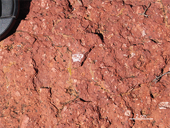
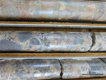
The Angle Dam Dacite (Fig. 4a) is a porphyritic volcanic which forms the oldest unit of the Gawler Range Volcanics in the Roopena area, and is overlain by alluvial conglomerates (Fig. 4b) and sandstones of the lower Fresh Well Formation which mark the first phase of sedimentation within the basin (Fig. 3a). Sedimentation was interrupted by extrusion of the lower Roopena Basalt (Fig. 3b), which contains local hyaloclastite breccia (Fig. 4c), indicating rapid quenching of lava due to interaction with water or wet sediment within the basin.
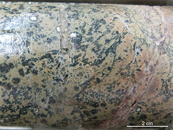
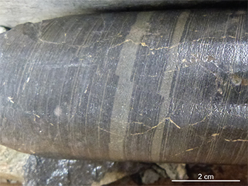
The overlying upper Fresh Well Formation marks the major period of sedimentation within the Roopena Basin (Fig. 3c). It comprises a succession of volcaniclastic claystone (Fig. 4d), siltstone and sandstone deposited in a fluviolacustrine setting. The upper Fresh Well Formation contains three coarsening-upwards prograding sedimentary packages with sharp basal contacts (Fig. 2), suggesting rapid flooding events occurred within the basin. Three tuffaceous beds within this formation provide evidence of extra-basinal explosive felsic volcanism during sedimentation (Fig. 2). Detrital zircon geochronology of a sandstone within the Fresh Well Formation yielded a maximum depositional age of c. 1580 Ma, with provenance dominated by magmatic zircons of the c. 1635–1605 Ma St Peter Suite (Fig. 5; Curtis, Wade and Reid 2018). Significant sedimentation within the basin was terminated by extrusion of the upper Roopena Basalt (Fig. 3d), which is the uppermost unit preserved within the succession and contains up to 11 distinct lava flows. Thin sedimentary intervals and peperite development within the upper Roopena Basalt indicate that minor sedimentation occurred during volcanism (Fig. 2).
The Fresh Well Formation and underlying Paleoproterozoic basement locally contain hematite–chlorite–sericite alteration, permissive of hematite-style IOCG deposits, which have been the focus of a number of exploration programs in the Roopena area, including Australian Selection in the 1980s (Samedan of Australia and Esso Australia Ltd 1985) and more recently Renascor Resources (2018).
Figure 3 Stylised block diagrams illustrating the temporal evolution of the Roopena Basin.
Figure 4 Units of the lower Gawler Range Volcanics, Roopena Basin. Reprinted from Curtis, Wade and Reid (2018; figs 5a, 5b, 5d and 5g).
Figure 4a Angle Dam Dacite, composed of feldspar and quartz phenocrysts in a fine-grained groundmass. (Sample from longitude 137.3830°, latitude 32.7491°; photo 416682)
Figure 4c Hyaloclastite developed at base of lava in Roopena Basalt, composed of poorly sorted angular basalt fragments. (ROOPENA DDH 1/drillhole number 19796, ~131 m; photo 416684)
Implications
Figure 5 Probability density distribution of detrital zircons from (a) a sample of the Fresh Well Formation (Curtis, Wade and Reid 2018) and (b) bedded clastic facies at Olympic Dam (data from McPhie et al. 2016). Probability density plots drawn using AGEDISPLAY (Sircombe 2004). Reprinted from Curtis, Wade and Reid (2018; fig. 9).
The development of sedimentary basins synchronous with extrusion of the Gawler Range Volcanics at Roopena, Olympic Dam and Prominent Hill all occur within the eastern Gawler Craton. The coincidence of sedimentation and mafic volcanism suggests that this region underwent at least localised extension in the early Mesoproterozoic. This is consistent with the overall extensional tectonic environment envisaged to be a factor in the formation of IOCG deposits (Hitzman, Oreskes and Einaudi 1992).
It is possible that these sedimentary packages preserved now as relics within either hematite breccia systems (e.g. Olympic Dam) or as fault bound domains could have originally formed a much larger sedimentary basin system across the eastern Gawler Carton. If this was the case, it raises questions about the possible significance of a larger, water-rich sedimentary basin interacting with deep-sourced magmatic hydrothermal fluids across the eastern Gawler Craton. Indeed, the concept that the sedimentary rocks at Olympic Dam were part of a previously larger basin was suggested by McPhie et al. (2011) based on interpretation of a distal source for detrital chromite and volcanic quartz in the bedded sedimentary facies rocks at the deposit.
However, we favour the concept that these basins were more likely to have been relatively restricted in extent. While the Roopena Basin was undoubtedly larger than the currently preserved area, the immaturity of sediments suggests that the basin was unlikely to have been orders of magnitude larger than what is preserved. Indeed, the detrital zircon age patterns recovered from the sample of the Fresh Well Formation in the Roopena Basin are significantly different from those derived from the Olympic Dam deposit (Fig. 5), which certainly supports the notion that these two packages were not part of a connected basin. In addition, sedimentary rocks preserved elsewhere in the Gawler Range Volcanics tend to form relatively thin interlayers within the dominantly volcanic units, for example in the Myall Creek (Simpson 2017) and Peltabinna areas (Werner et al. 2017), supporting the relatively local, restricted nature of sedimentation at this time.
Narrow fault-bound basins can be found in regions undergoing limited extension, or also in regions undergoing transpression or transtension, in which zones of lateral faulting form pull-apart basins. Where such lateral movements are connected to deeper, lithospheric structures, the often vertical or subvertical nature of these deformation zones can facilitate the transport of mantle-derived magmas and fluids into an upper crustal setting. Steep structures are identified in some interpretations of the seismic and magnetotelluric surveys across Olympic Dam (Heinson et al. 2018; Wise et al. 2016). It is probable that strike-slip, normal or oblique-slip faulting synchronous with emplacement of the Gawler Range Volcanics may have contributed to the formation of localised sedimentary basins. If these basins are structurally controlled (McPhie et al. 2011) it is possible that these same structures may have facilitated magmatic emplacement and fluid flow that contributed to the formation of the IOCG deposits.
The Roopena area lies within the Olympic Cu–Au Province, connecting the hematite-style IOCG deposits in the broader Olympic Dam area with the skarn-style IOCG deposits on Yorke Peninsula. We note that the presence of localised hematite–chlorite–sericite (white mica) alteration within the Fresh Well Formation and underlying basement within the Roopena Basin is characteristic of other hematite-style IOCG deposits and prospects within the Gawler Craton (Skirrow 2009). In addition, directly to the west of the Roopena area the presence of quartz veins associated with fluorite, barite, muscovite, feldspar, kaolinite, halloysite and smectite, and enrichment in elements such as Ag, Sb, Te, Bi, Cu, Pb and Z, are consistent with low-sulfidation, argillic alteration (Wade et al. 2014), suggesting that the upper crustal part of this lithosphere-scale hydrothermal system is also preserved. Nevertheless, no significant IOCG-style mineralisation has yet been discovered in the Roopena Basin.
Footnote
1 Originally defined as Angle Dam Volcanics (McAvaney and Wade 2015). The Geological Survey of South Australia has initiated the process to formally change the name to Angle Dam Dacite to reflect the dominant lithology. (Back)
References
Belperio AP, Flint RB and Freeman H 2007. Prominent Hill: a haematite-dominated iron oxide-copper-gold system. Economic Geology 102:1499–1510.
Bull S, Meffre S, Allen M, Freeman H, Tomkinson M and Williams P 2015. Volcanosedimentary and chronostratigraphic architecture of the host rock succession at Prominent Hill, South Australia. SEG 2015: World-Class Ore Deposits: Discovery to Recovery, Conference Proceedings (PDFs of abstracts and oral and poster presentations). Society of Economic Geologists, Hobart, Tasmania.
Haynes D, Cross KC, Bills RT and Reed MH 1995. Olympic Dam ore genesis; a fluid-mixing model. Economic Geology 90(2):281–307.
Heinson G, Didana Y, Soeffky P, Thiel S and Wise T 2018. The crustal geophysical signature of a world-class magmatic mineral system. Scientific Reports 8:10608(2018).
Hitzman MW, Oreskes N and Einaudi MT 1992. Geological characteristics and tectonic setting of Proterozoic iron oxide (Cu-U-Au-LREE) deposits. Precambrian Research 58:241–257.
McPhie J, Kamenetsky VS, Chambefort I, Ehrig K and Green N 2011. Origin of the supergiant Olympic Dam Cu-U-Au-Ag deposit, South Australia: was a sedimentary basin involved? Geology 39(8):795–798.
McPhie J, Orth K, Kamenetsky VS, Kamenetsky M and Ehrig K 2016. Characteristics, origin and significance of Mesoproterozoic bedded clastic facies at the Olympic Dam Cu-U-Au-Ag deposit, South Australia. Precambrian Research 276:85–100.
Renascor Resources 2018. Eastern Eyre Project: IOCG, Renascor Resources, viewed July 2018.
Sircombe KN 2004. AGEDISPLAY: an Excel workbook to evaluate and display univariate geochronological data using binned frequency histograms and probability density distributions. Computers & Geosciences 30(1):21–31.
Skirrow RG 2009. ‘Hematite-group’ IOCG±U ore systems: tectonic settings, hydrothermal characteristics, and Cu-Au and U mineralizing processes. In L Corriveau and H Mumin eds, Exploring for iron oxide copper-gold deposits: Canada and global analogues, Shortcourse Notes, GAC-MAC-SEG-SGA 2008, Quebec City, 29–30 May 2008. Geological Association of Canada, pp. 39–58.
Skirrow R, Bastrokov E, Barovich K, Fraser G, Creaser RA, Fanning CM, Raymond O and Davidson GJ 2007. Timing of iron oxide-Cu-Au-(U) hydrothermal activity and Nd isotope constraints on metal sources in the Gawler Craton, South Australia. Economic Geology 102:1441–1470.


