Stacey O McAvaney , Carmen BE Krapf, Mario Werner, Mark J Pawley, Ben E Nicolson and Jonathan A Irvine
Geological Survey of South Australia, Department of State Development
Download this article as a PDF (6.4 MB); cite as MESA Journal 82, pages 20–30
Introduction
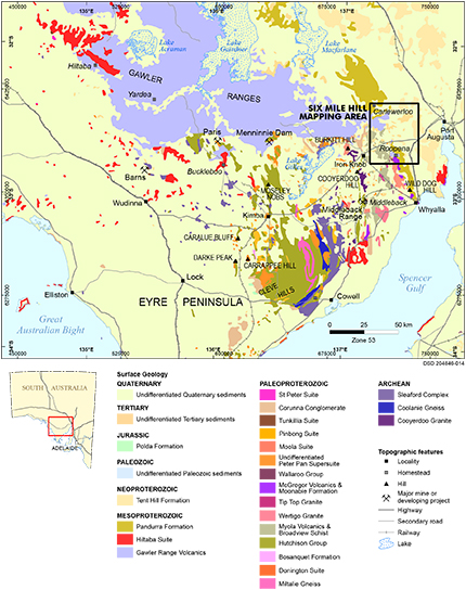
Figure 1 Outcropping geology and mineral deposits of northern Eyre Peninsula, showing the location of the Six Mile Hill Special Map.
The southern margin of the Gawler Ranges on northern Eyre Peninsula is identified as one of South Australia’s emerging mineral provinces (Fig. 1). The region is prospective for a range of deposit styles formed during the magmatic event which produced the Gawler Range Volcanics (c. 1590 Ma) and Hiltaba Suite (c. 1595–1575 Ma), and was responsible for the formation of iron oxide – copper–gold (IOCG) deposits in the eastern Gawler Craton and shear-hosted gold in the central Gawler Craton (Ferris and Schwarz 2003; Fraser, Skirrow and Holm 2007). The northern Eyre Peninsula preserves high crustal levels close to the c. 1590 Ma paleosurface, and thus also has high potential to host epithermal-style mineralisation similar to the Paris and Menninnie Dam deposits.
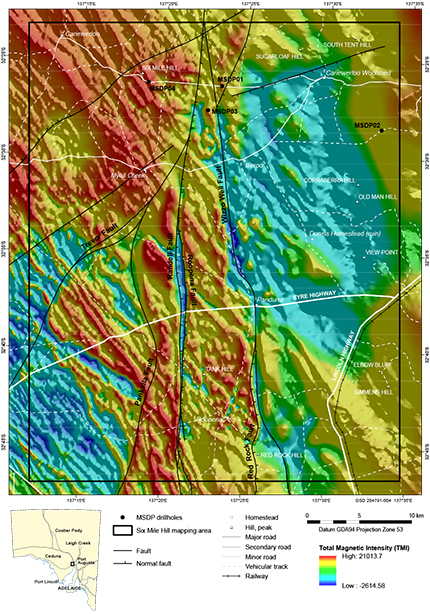
In an attempt to identify regional-scale vectors to mineralisation and map alteration and geochemical footprints under cover, the 2015–2016 Mineral Systems Drilling Program (MSDP) was instigated along the southern margin of the Gawler Ranges (Fabris in prep.). Program participants included the Geological Survey of South Australia (GSSA), Deep Exploration Technologies Cooperative Research Centre (DET CRC), Kingston Resources and Minotaur Exploration. A geological mapping program was undertaken in association with the MSDP to provide a regional geological context in which the stratigraphy, alteration and mineralisation of the MSDP drilling could be interpreted. Detailed basement, structural and regolith mapping was carried out in combination with remote-sensing and orthophoto interpretation utilising high-resolution enhanced orthoimagery, digital elevation model (DEM), total magnetic intensity (TMI) and gravity data.
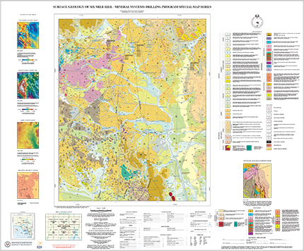
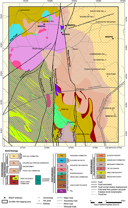
The Six Mile Hill map releases are the first products from the MSDP mapping program and comprise the results for the first of the three MSDP drilling areas at Six Mile Hill, located ~30 km WNW of Port Augusta. Six Mile Hill spans a number of geological provinces, including the Mesoarchean–Mesoproterozoic Gawler Craton, Mesoproterozoic Cariewerloo Basin and Neoproterozoic Stuart Shelf, as well as preserving a protracted history of deposition in the Cenozoic (Fig. 1). The releases include the 1:75,000 scale surface geology map (Krapf et al. 2016; Fig. 2), interpreted bedrock geology map (Pawley et al. 2016) and explanatory notes (McAvaney et al. 2016b).
This article provides a summary of some of the key outcomes of the mapping program, including new constraints on Paleoproterozoic and Mesoproterozoic magmatism, structural evolution of the region during the Paleoproterozoic through to the Cenozoic, and characterisation of transported and in situ regolith materials and landforms.
Paleoproterozoic mafic magmatism: Wire Dam Dolerite
Between 2000 and c. 1740 Ma the Gawler Craton underwent a prolonged period of extension which led to the development of large, lithologically complex shallow marine to continental basins, including the Hutchison Group (Szpunar et al. 2011), Wallaroo Group (Zang 2006) and sediments in the Nawa Domain (Payne, Barovich and Hand 2006). On Six Mile Hill this basin system is represented by sandstones and siltstones of the Broadview Schist which is interpreted to have been deposited in a marine shoreface environment, broadly coeval with the c. 1795 Ma felsic Myola Volcanics (McAvaney et al. 2016b).
Mafic rocks intruding sandstones of the c. 1790 Ma Broadview Schist were previously mapped as a subunit of the Broadview Schist (Weste 1996). However, as there is unlikely to be a petrogenetic relationship between the mafic intrusive rock and the hosting metasedimentary rocks, these mafic rocks have been defined as a distinct geological unit named the Wire Dam Dolerite.
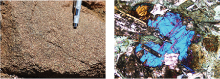
The Wire Dam Dolerite forms sills up to 50 m thick of variably foliated, epidote-altered, fine- to coarse-grained, equigranular, dark green dolerite (Fig. 3a) to gabbro, with minor basalt. The thicker sheets are zoned with doleritic margins (up to 10–15 m wide) and cores (up to 20 m wide) of dark grey-green, medium- to coarse-grained, inequigranular gabbro. Thinner sheets are composed of very fine to fine-grained, well-foliated metabasalt. The dolerite has an ophitic texture of interlocking tabular feldspars and clinopyroxene, with less common prismatic to equant amphibole grains (Fig. 3b). The sills of the Wire Dam Dolerite are shallowly to moderately dipping, and are deformed by a sporadically developed tectonic foliation defined by elongate feldspar aggregates and aligned amphibole which dips moderately to steeply to the SW, parallel to that developed in the Broadview Schist.
The age of the Wire Dam Dolerite is constrained between c. 1795 Ma and c. 1775 Ma. The older constraint is the maximum depositional age of the host Broadview Schist (Fraser and Neumann 2010). The younger constraint is provided by the age of the c. 1775 Ma Tip Top Granite (McAvaney, Wade and Jagodzinski 2016a), which is observed to intrude along the foliation in the Broadview Schist while itself being overprinted by this foliation, suggesting that magma intrusion was syndeformational.
Mesoproterozoic bimodal magmatism: Gawler Range Volcanics
The Gawler Range Volcanics and comagmatic Hiltaba Suite represent a major phase of magmatism in the Gawler Craton which was associated with mantle-derived magmas, widespread crustal melting, and the introduction of magmatic fluids and metals into the crust, driving the formation of regional mineral systems, including IOCG deposits in the eastern Gawler Craton and shear-hosted gold in the central Gawler Craton. Both mafic volcanics and sedimentary basin fluids are thought to be important factors in the formation of these mineral systems (Skirrow et al. 2007; McPhie et al. 2011).
During mapping of Six Mile Hill, a new sequence of bimodal volcanics of the lower Gawler Range Volcanics was identified in outcrop and in the MSDP drillholes, which underlies the Eucarro Rhyolite. The sequence has a variable thickness, exceeding 1,000 m in MSDP01 (SA Geodata drillhole number 287995), and comprises rhyolitic to dacitic lavas and ignimbrites, and basalt lavas interlayered with mafic volcaniclastic sediments. Chemical abrasion - thermal ionisation mass spectrometry (CA-TIMS) ages indicate that this sequence was emplaced at c. 1591 Ma.
The felsic volcanics include massive, evenly porphyritic rhyolitic to dacitic lavas composed of euhedral to subhedral feldspar and round to embayed quartz and pyroxene or hornblende phenocrysts in a fine-grained quartzofeldspathic groundmass (Fig. 4a). Some lavas preserve perlitic fractures indicating that the lavas were originally glassy (Fig. 4b). Rhyolitic to dacitic ignimbrites are composed of crystal and lithic fragments in a vitriclastic to eutaxitic matrix, sometimes preserving flattened pumice lapilli (Fig. 4c). Occurrences of vitric tuff were identified in outcrop composed of undeformed bubble-wall glass shards, interpreted to have been deposited as a subaerial or lacustrine air-fall volcanic ash deposit (Fig. 4d).
The basalts are aphyric to megacrystic (Fig. 5a), amygdaloidal and auto-brecciated lavas which preserve hyaloclastite or peperite margins, suggesting they were emplaced subaqueously or came into contact with standing water or wet unconsolidated sediments. They are interlayered with poorly sorted basaltic volcaniclastic breccia (Fig. 5b), sandstone and mudstone interpreted to have been deposited in a fluvial to fluviolacustrine environment.
The Gawler Range Volcanics on Six Mile Hill are interpreted to have been part of a bimodal volcanic field, consisting of a small felsic volcanic centre or centres with alternating phases of effusive and explosive activity, overlapping spatially with a basaltic volcanic centre or centres and a fluviolacustrine sedimentary system, akin to the Quaternary bimodal volcanism of the Eastern Snake River Plain in the USA (Branney et al. 2008).
New deformation event recognised at c. 1775 Ma
The majority of studies of deformation in the southern Gawler Craton have focused on the high-temperature deformation and metamorphism of the c. 1730–1690 Ma Kimban Orogeny recorded on southern, central and western Eyre Peninsula (Tong, Wilson and Vassallo 2004; Dutch, Hand and Kinny 2008; Lane et al. 2015). However, on northeastern Eyre Peninsula the metamorphic grade of the Kimban Orogeny is considerably lower, and an earlier tectonic fabric predating the Kimban Orogeny is observed affecting the c. 1795 Ma Broadview Schist, Wire Dam Dolerite and c. 1775 Ma Tip Top Granite. This deformation is best preserved in the structural domain between the Pankalla and Trevor faults (Fig. 6), and comprises upright NW-trending folding of the Broadview Schist and Wire Dam Dolerite. The rocks contain a subvertical NW-striking foliation axial planar to folding. The age of this deformation is constrained to c. 1775 Ma by the magmatic age of the Tip Top Granite (McAvaney, Wade and Jagodzinski 2016a), which is observed to intrude as sheets along the foliation of the Broadview Schist and is deformed by the same foliation.
Paleoproterozoic to Cenozoic tectonic reactivation
A series of north-trending, large-scale shear zones and faults transect Six Mile Hill (Fig. 6), which are generally not exposed, or are delineated by quartz blows, veining and neotectonic fault scarps (Krapf et al. 2015). New mapping and integration of drillhole data have revealed a prolonged reactivation history of these faults on Six Mile Hill that can be traced from the Paleoproterozoic to the present.
Kimban compressional deformation
The Roopena and Pankalla faults preserve evidence of movement during the c. 1730–1690 Ma Kimban Orogeny, and are part of a broader fault splay system extending from the Kalinjala Mylonite Zone on southern Eyre Peninsula (Parker 1980; Vassallo and Wilson 2002). Kimban-aged movement is interpreted to have affected the c. 1775 Ma fabric within the Broadview Schist, Wire Dam Dolerite and Tip Top Granite in the block bounded between the Roopena and Pankalla faults. Fault-block rotation resulted in the sharp change in the strike of the axial planar solid-state from NW-striking to the west to NNW-striking, as well as steepening and transposition of the folded bedding and the axial-planar foliation, and the development of a mylonitic foliation adjacent to the Roopena Fault. This deformation occurred during WSW- to ENE-directed shortening.
Mesoproterozoic extension
During the Mesoproterozoic the Roopena and Wizzo Well faults were active as extensional structures, and defined the margins of a fault-bound north-trending volcaniclastic basin in which the Roopena Basalt and lacustrine sediments of the Fresh Well Formation of the Gawler Range Volcanics were deposited (McAvaney and Wade 2015). Three prograding packages within the Fresh Well Formation have sharp basal contacts, suggesting that there were rapid flooding events likely to have been generated by extensional fault movement.
Neotectonism
The Roopena Fault is exposed as a modern scarp and preserves evidence of neotectonic movement. The scarp is generally <5 m high and is mostly expressed as a broad, gentle warp with maximum slope angles typically <10° in an overall flat to undulating landscape. Surficial deposits in the area of the Roopena Fault Scarp are mainly locally derived fine-grained colluvium, composed of fragments from adjacent weathered bedrock along with alluvial sands and gravels associated with the modern drainage system. The fault scarps affected modern drainage systems, resulting in ponding, diverting or rejuvenation of older channels, or the promotion of new channels (Krapf et al. 2015). Optical stimulated luminescence dating of sediments exposed in three trenches along the Roopena Fault Scarp revealed surface rupturing occurred about 200–150 ka, 100 ka and 30–27 ka (Crone et al. 2003).
Characterising the cover
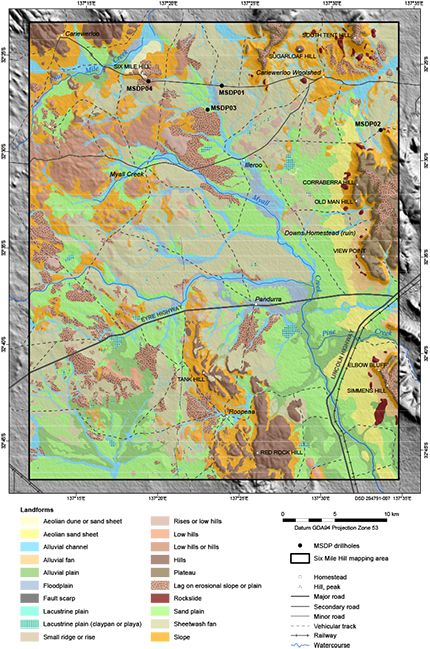
Understanding the type and thickness of sedimentary cover is critical to exploring for buried deposits and determining the suitability of the cover material as a sampling medium for detecting the mineral footprints of buried deposits. Detailed mapping of transported and in situ regolith materials and associated landforms resulted in the subdivision of 24 Cenozoic units on Six Mile Hill which can be assigned to 20 landforms (Fig. 7). These include silcretes, ferricretes, various lag types, landslide deposits, colluvial, alluvial, lacustrine, aeolian and mixed transported regolith materials, and calcrete induration.
Given the extensive deep weathering of basement lithologies on northern Eyre Peninsula, the surface geology has been mapped using a system of piggyback codes so that the nature of the surface expression of Paleoproterozoic basement sequence beneath the regolith is represented, such as deeply weathered (dw), silicified (si), lag (lg) or calcrete (Qca; Fig. 2).
Sandplains
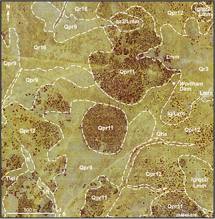
Figure 8 Orthophoto overlain with stratigraphic units showing the difference in vegetation style and cover between Qpr9, Qpr10 and Qpr12 around the vicinity of Wortham Dam.
Sandplains cover vast parts of Six Mile Hill, and have been subdivided based on composition and vegetation cover: Qpr9 is vegetated by saltbush and/or bluebush, Qpr10 by various shrubs and trees, Qpr11 by myall trees and Qpr12 by grass, low shrub and minor trees (Fig. 8). The sandplains are often the link between colluvium, alluvial fans and sheetwash fans and alluvial plains, floodplains and drainage channels. The sandplain deposits represent sediments accumulated on depositional plains due to alluvial and sheetwash processes with minor aeolian input. Aeolian and pluvial processes on the surface resulted in the removal of finer material leading to the formation of surface lags with various compositions and density, usually reflecting the underlying bedrock geology and/or substrate. In addition, on the surface of some sandplains microbial mats and mudcracks are present where they are located in a low-landscape position in close proximity to drainage systems where episodic flooding occurs.
Silcretes
Silcrete outcrops and subcrops on Six Mile Hill commonly occur on top of rises and on slopes of silcrete-topped breakaways, and are closely associated downslope with silcrete lags or silcrete-rich colluvium. A variety of silcrete morphologies occur on Six Mile Hill, and a close relationship between silcrete morphology and the bedrock lithotype has been observed (Krapf and Werner 2016), which in many cases aided in the interpretation of the underlying basement geology.
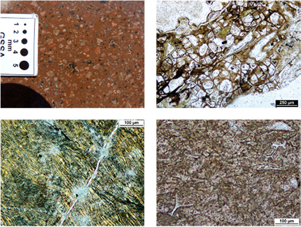
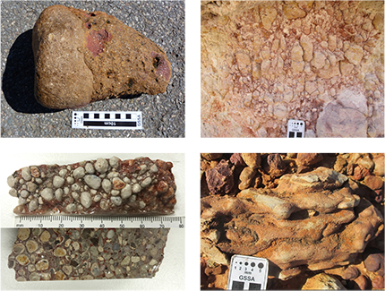
Silcretes associated with conglomerates include silcrete columns or cones attached to rock clasts, which have formed in situ within the conglomerate (Fig. 9a). Silcretes are most commonly developed within the quartz-rich, arenaceous zone of highly weathered lithotypes of different stratigraphic units, including the Sugarloaf Dam Sandstone, Pandurra Formation and Adelaidean sediments (Fig. 9b). Glaebular silcretes are also associated with sandstones, and are characterised by discrete glaebules composed of reworked silicified quartzose sediment or silcrete clasts which have multiple silica- and titania-rich layers ranging in thickness from microscopic to several millimetres (Fig. 9c). Groundwater silcretes are also observed, which are grey and massive with fluted surfaces, and were formed in a vadose soil or pedolith water environment (Fig. 9d).
Future releases
The Six Mile Hill 1:75,000 surface geology map, 1:75,000 interpreted bedrock geology map and explanatory notes are the first products to be released from the MSDP. The maps and explanatory notes for the Peltabinna MSDP drilling area and the Mount Double drilling area, on the southwestern margin of the Gawler Ranges, will be released later in 2017.
Acknowledgements
We thank Luke Tylkowski, Adrian Fabris and John Brennan from the GSSA and Stuart Rechner from Kingston Resources for providing support to our mapping program, as well as the owners of Pandurra, Myall Creek and Cariewerloo stations. Anthony Reid (GSSA) is thanked for providing valuable suggestions for the outline of this article.
References
Branney MJ, Bonnichsen B, Andrews GDM, Ellis B, Barry TL and McCurry M 2008. 'Snake River (SR)-type' volcanism at the Yellowstone hotspot track: distinctive products from unusual, high-temperature silicic super-eruptions. Bulletin of Volcanology 70:293–314.
Crone AJ, De Martini PM, Machette MN, Okumura K and Prescott JR 2003. Paleoseismicity of two historically quiescent faults in Australia: implications for fault behaviour in stable continental regions. Bulletin of the Seismological Society of America 93:1913–1934.
Dutch R, Hand M and Kinny PD 2008. High-grade Palaeoproterozoic reworking in the southeastern Gawler Craton, South Australia. Australian Journal of Earth Sciences 55:1063–1081.
Fabris AJ in prep. Mineral Systems Drilling Program in the southern Gawler Ranges, South Australia, Report Book 2016/00030. Department of State Development, South Australia, Adelaide.
Fraser GL and Neumann NL 2010. New SHRIMP U-Pb zircon ages from the Gawler Craton and Curnamona Province, South Australia, 2008-2010, Record 2010/16. Geoscience Australia, Canberra.
Fraser G, Skirrow R and Holm O 2007. Mesoproterozoic gold prospects in the central Gawler Craton, South Australia: geology, alteration, fluids and timing. Economic Geology 102:1511–1539.
Krapf CBE and Werner MX 2016. Silcretes of the NE Eyre Peninsula and their association with the underlying bedrock. Fourth Australian Regolith Geoscientists Association Conference, Proceedings. Australian Regolith Geoscientists Association, pp. 57–58.
Lane K, Jagodzinski EA, Dutch R, Reid AJ and Hand M 2015. Age constraints on the timing of iron ore mineralisation in the southeastern Gawler Craton. Australian Journal of Earth Sciences 62:55–75.
McPhie J, Kamenetsky VS, Chambefort I, Ehrig K and Green N 2011. Origin of the supergiant Olympic Dam Cu-U-Au-Ag deposit, South Australia: was a sedimentary basin involved? Geology 39:795–798.
Payne JL, Barovich K and Hand M 2006. Provenance of metasedimentary rocks in the northern Gawler Craton, Australia: implications for Palaeoproterozoic reconstructions. Precambrian Research 148:275–291.
Skirrow R, Bastrokov E, Barovich K, Fraser G, Creaser RA, Fanning CM, Raymond O and Davidson GJ 2007. Timing of iron oxide Cu-Au-(U) hydrothermal activity and Nd isotope constraints on metal sources in the Gawler Craton, South Australia. Economic Geology 102:1441–1470.
Szpunar M, Hand M, Barovich K and Jagodzinski EJ 2011. Isotopic and geochemical constraints on the Palaeoproterozoic Hutchison Group, southern Australia: implications for Palaeoproterozoic reconstructions. Precambrian Research 187:99–126.
Tong L, Wilson CJL and Vassallo J 2004. Metamorphic evolution and reworking of the Sleaford Complex metapelites in the southern Eyre Peninsula, South Australia. Australian Journal of Earth Sciences 51:571–589.
Vassallo JJ and Wilson CJL 2002. Palaeoproterozoic regional-scale non-coaxial deformation: an example from eastern Eyre Peninsula, South Australia. Journal of Structural Geology 24:1–24.


