Mark Pawley1, Rian Dutch1, 2 and Tom Wise1
1 Geological Survey of South Australia, Department for Energy and Mining
2 Department of Earth Sciences, University of Adelaide
Download this article as a PDF (1.5 MB); cite as MESA Journal 95, pages 41–48
Published October 2021
Introduction
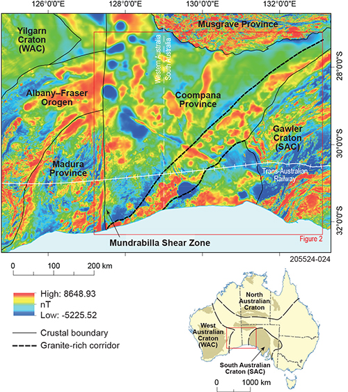
Figure 1 Locality map of the Coompana Province and surrounding regions showing the main crustal boundaries and granite-rich corridor overlain on a reduced to pole aeromagnetic image. Seismic line 13GA-EG1E followed the railway. The inset shows the study area and main cratonic blocks of Australia. Reprinted from Pawley et al. (2020a, fig 1, p 3) under CC BY-NC 4.0.
The Coompana Province is a completely buried Proterozoic terrane between the South Australian, Western Australian and North Australian cratons (Fig 1). As a result of the location, the province is a key area for understanding the Proterozoic evolution of Australia and has featured heavily in reconstructions and models. However, until recently, very little was known about the area due to a paucity of data, with only broad-scale geophysics and a few basement-intersecting drillholes. Consequently, there have been very few constraints on these models. This has recently been addressed with the collection of a large amount of data from across the Coompana Province including the east–west-trending 13GA-EG1E seismic line (Pawley et al. 2018), 400 m line spacing aeromagnetic data (Heath et al. 2015), and drill campaigns in the eastern and western parts of the province (Dutch et al. 2018; Spaggiari and Smithies 2015).
As an outcome of these projects, we have recently published an open access article in Tectonics (Pawley et al. 2020a). Here we provide a summary of this paper showing how we integrated the aeromagnetic, seismic and drillhole data to resolve a c. 1200–1140 Ma tectonomagmatic event in the eastern Coompana Province. This event affected large areas of the Coompana Province and involved several stages of deformation and accompanying magmatism. The new work provides constraints and understanding of the Coompana Province in terms of (1) crustal architecture (2) c. 1200–1140 Ma structural history, and (3) relationship between deformation and magmatism.
Setting of the Coompana Province
The Coompana Province is a large tract of crust in central southern Australia that is completely covered by Neoproterozoic to Cenozoic basins (Fig 1). To the west, it is separated from the Madura Province by the north-trending Mundrabilla Shear Zone (Figs 1, 2; Aitken et al. 2016). To the east, it is separated from the Gawler Craton by the arcuate, west-dipping Jindarnga Shear Zone (Doublier et al. 2015; Pawley et al. 2018). To the north, it is separated from the Musgrave Province by the north-dipping Everard Thrust (Major and Conor 1993; Preiss et al. 2010). The Musgrave Province is defined as a separate crustal block, as it was thrust up and exhumed from beneath the Centralian Superbasin during the c. 630–520 Ma Petermann Orogeny (Camacho and Fanning 1995; Major and Conor 1993; Quentin de Gromard et al. 2019; Sandiford and Hand 1998). However, geochemistry, geochronology and geophysical data reveal that the Musgrave and Coompana provinces were likely formerly continuous (Dutch et al. 2016; Smits et al. 2014; Thiel et al. 2020).
The history of the basement rocks in the Coompana Province can be broken into 2 main stages, older than 1500 Ma and c. 1200–1140 Ma.
Subduction and arc magmatism occurred between c. 1618 and 1526 Ma, consuming c. 2000–1900 Ma oceanic crust (Hartnady et al. 2020; Kirkland et al. 2017). The c. 1618 Ma migmatitic orthogneisses of the Koomalboogurra Suite (Dutch 2018; Jagodzinski et al. 2019; Wingate et al. 2015) are similar in age and composition to the St Peter Suite in the southern Gawler Craton. The St Peter Suite rocks are interpreted to represent subduction-related granites that developed on the edge, or outboard of the Gawler Craton (Dutch et al. 2016; Reid et al. 2019; Swain et al. 2008). The c. 1526 Ma migmatitic orthogneisses of the Bunburra Suite have a juvenile isotopic character and primitive geochemical signatures. These indicate the Bunburra Suite was derived from a subduction-enriched lithospheric mantle source (Dutch 2018; Pawley et al. 2020b). The c. 1505 Ma Gilgerabbie Suite in the eastern Coompana Province (Wade et al. 2007) is considered to be part of the c. 1505–1487 Ma A-type Undawidgi Supersuite that was recognised in the western Coompana Province (Wingate et al. 2015). The Undawidgi Supersuite is interpreted to be the product of intracontinental extension (Smithies et al. 2015) following cessation of c. 1526 Ma subduction.
Over the interval c. 1200–1070 Ma, the Coompana Province underwent 2 stages of intraplate magmatism, which resulted in 2 compositionally distinct magmatic suites. The first stage includes the mafic–intermediate c. 1174 Ma Merdayerrah and Bottle Corner shoshonites and felsic c. 1150–1140 Ma Koonalda Suite (Dutch 2018; Jagodzinski et al. 2019; Pawley et al. 2020b; Smithies et al. 2015; Wise et al. 2018a). These 2 units have relatively juvenile ɛHf1174–1140 Ma values, suggesting they were the product of mantle input and the assimilation of crust similar to the Bunburra and Koomalboogurra suites (Dutch 2018).
The second stage of intraplate magmatism produced the mafic c. 1074 Ma Giants Head and Warbla suites (Dutch 2018; Jagodzinski et al. 2019; Pawley et al. 2020b; Wise et al. 2018a). These 2 units are compositionally distinct, and are the result of melting heterogeneous lithospheric mantle (Dutch 2018). The Giants Head Suite has evolved (strongly negative) ɛHf1074 Ma values, indicating the magmas were contaminated by >1900 Ma crust (Dutch 2018). A highly reflective lower crustal unit in the seismic section is interpreted to be an extension of the older Gawler Craton crust beneath the Coompana Province that locally contaminated the ascending mantle melts (Pawley et al. 2018; Wise et al. 2018a).
Crustal architecture of the Coompana Province
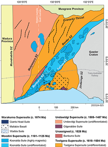
Figure 2 Interpreted basement map of the Coompana Province (modified from Wise et al. 2018b). Reprinted from Pawley et al. (2020a, fig 2, p 4) under CC BY-NC 4.0.
The aeromagnetic, seismic and drillhole data reveal 4 crustal domains in the Coompana Province (Fig 2). These domains have distinct crustal architecture and geological histories. The main observations are presented in Figure 3.
Southeast domain
The southeast domain is located between the Jindarnga and Palinar shear zones and the coast (Fig 2). The domain is characterised by 3-layer crust in the seismic profile. The upper crust has 2 main magnetic patterns. To the west, the domain has a northeast-trending planar magnetic grain, aligned subparallel to the adjacent Palinar Shear Zone. This grain corresponds to the migmatitic Koomalboogurra Suite. This suite has c. 1618 Ma protoliths that were generated in a proximal back-arc (Dutch 2018; Jagodzinski et al. 2019), and was metamorphosed between c. 1163 and 1140 Ma (Jagodzinski et al. 2019). The migmatitic rocks have a shallowly dipping compositional layering, which has been folded into recumbent folds that plunge shallowly to the north and south (Fig 4b). The migmatitic layering is locally offset by west-dipping reverse shears, which are filled with melt that is texturally continuous with the shallowly dipping leucosomes. The central and eastern parts of the domain are characterised by arcuate to concentric long wavelength, moderate to highly magnetic anomalies that reach up to 40 km across. These anomalies correspond to granitic gneisses with protoliths generated in an extensional setting at c. 1505 Ma (Wade et al. 2007).
Northeast-trending corridor
To the east is a northeast-trending corridor bound by the Palinar and Border shear zones (Fig 2). This corridor is up to 80 km wide at the surface and can be traced along strike for about 800 km, from the coast in Western Australia to the northern margin of the Gawler Craton. On the seismic profile, this corridor corresponds to a zone of thinned crust with 2 distinct layers. On aeromagnetic images, the corridor is prominent as a series of overlapping, elongate magnetic plutons. The magnetic plutons within the corridor were targeted during the drill campaign and found to comprise massive porphyritic syenogranite to monzogranite dated at c. 1149 Ma (Jagodzinski et al. 2019). The basement rocks hosting the granites in the western part of the corridor are diatexites with a pervasive migmatitic layering. The protolith was emplaced at 1526 ± 5 Ma and is part of the Bunburra Suite, with metamorphism and partial melting occurring at 1197 ± 12 Ma (Jagodzinski et al. 2019). The diatexites also contain sheets of the 1174 ± 9 Ma Merdayerrah Shoshonite (Jagodzinski et al. 2019), which are foliated and aligned subparallel to the migmatitic layering. The migmatitic layering and foliated shoshonite are both folded into mesoscopic recumbent folds that plunge shallowly to moderately to the south.
Central Coompana Province
The central Coompana Province is a triangular crustal domain northwest of the Border Shear Zone that is bound to the east by the Border Shear Zone, west by the Mulyawara Shear Zone and north by the Everard Thrust. (Fig 2). The seismic profile indicates there is 2-layer crust in this area. The upper crust contains abundant evidence for west-dipping extensional faulting with syndeformational magma emplacement. The aeromagnetic images show a series of approximately north-trending, discontinuous, broad-wavelength magnetic highs that are truncated to the north and south by the Mulyawara and Border shear zones, respectively. The basement rocks in this area include c. 1613–1604 Ma arc-related rocks of the Toolgana Supersuite (Smithies et al. 2015; Wingate et al. 2015). These rocks underwent high-temperature metamorphism and anatexis at c. 1179–1150 Ma (Neumann and Korsch 2014; Wingate et al. 2015).
Western Coompana Province
The westernmost Coompana Province is a triangular crustal domain, bound by the Mulyawara Shear Zone to the east, the Mundrabilla Shear Zone to the west, and the Everard Thrust to the north (Fig 2). The seismic data shows 3-layer crust. The upper crust contains a series of interfingering east- and west-dipping extensional faults with syndeformational magma emplacement. Petrological constraints indicate the upper crust of the western Coompana Province underwent several episodes of extension. The upper crust is dominated by the c. 1505–1487 Ma Undawidgi Supersuite and c. 1192–1175 Ma Moodini Supersuite (Smithies et al. 2015; Wingate et al. 2015). The Undawidgi Supersuite represents recycling of the c. 1600 Ma arc crust with additional juvenile mantle input during extension (Kirkland et al. 2017; Smithies et al. 2015). The Moodini Supersuite includes the Bottle Corner Shoshonite, which represents melting of subduction-enriched lithosphere during extension and mantle upwelling (Smithies et al. 2015).
Deformation in the Coompana Province
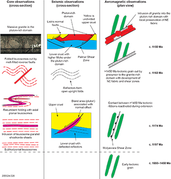
Figure 3 Summary of core, seismic and aeromagnetic observations and time constraints, eastern Coompana Province. Modified from Pawley et al. (2020a, fig 9, p 20) under CC BY-NC 4.0; ‘Hughes domain’ replaced with ‘pluton-rich domain’.
The c. 1200–1140 Ma deformation history of the eastern Coompana Province can be divided into 2 main stages (Fig 3). Early deformation (i.e. ≥c. 1174 Ma) involved widespread east–west-directed extension that produced flat-lying to shallowly dipping leucosomes that were recumbently folded. This stage of deformation was associated with volumetrically minor shoshonitic magmatism. Later deformation (i.e. ≤1163 Ma) was localised and largely partitioned into an oblique, northeast-trending extensional corridor between the Palinar and Border shear zones. This corridor focused crustal thinning and the voluminous c. 1150–1140 Ma A-type, high K–Fe granites (Dutch 2018; Jagodzinski et al. 2019; Kirkland et al. 2011). The A-type magmas represent melting of felsic crust during extension with the significant contribution of mafic to intermediate material (e.g. Dutch 2018; Smithies et al. 2011; Vaughan and Scarrow 2003). The 2 stages of extension appear to be separated by minor shortening that resulted in local reverse faulting and upright folding. This process suggests there was a transition from pervasive to locally partitioned deformation in the Coompana Province during the late Mesoproterozoic. The transition in deformation implies a change in the way the crust is responding to extension. During the early extension, the crust behaved in a more ductile manner with widespread deformation pervasively distributed throughout the crust. In contrast, the crust behaved in a more brittle manner during the second stage of extension, with strain largely focused into a discrete corridor.
There are 3 possible mechanism for the focused extension that occurred at c. 1163–1140 Ma.
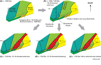
Figure 4 Structural evolution of the eastern Coompana Province between c. 1200 and 1150 Ma, with c–d showing the 3 possible scenarios. (a) Pre-1200 Ma configuration showing the approximately north-northeast-striking zones of >1490 Ma magmatic arc and extension-related igneous rocks, and the curved boundary with the Gawler Craton. (b) Pervasive extension between c. 1200 and 1160 Ma results in partial melting, the development of a shallowly dipping layering that is recumbently folded, extensional shearing (including reactivation of earlier structures), and shoshonitic magmatism. The shoshonite plutons are controlled by the extensional shear zones. (c) Continuation of extension until 1150 Ma results in strike-slip shear near the margin of the Gawler Craton, forming a tear that propagates to the southwest, with east–west extension partitioned into this zone. (d) A switch to shortening at c. 1150 Ma causes strike-slip shearing near the Gawler Craton contact, which propagates to the southwest, with deformation focu
sed into this zone. This requires north–south extension to create the zone of thinner crust. (e) Minor rotation in the region results in extension across the southeastern Coompana Province when east–west-directed shortening is occurring across the Musgrave Province to the north. Reprinted from Pawley et al. (2020a, fig 10, p 22) under CC BY-NC 4.0.
First, east–west-directed extension continued in the Coompana Province until c. 1140 Ma, causing listric shearing and thinning of the crust and intrusion of the A-type granites (Fig 4c). The change from pervasive strain to localised shearing and extension would represent a change in the behaviour of the crust under the same stress field. One problem with this model is that the Musgrave Province was undergoing approximately east–west-directed shortening at c. 1150–1140 Ma (Pawley et al. 2016), when the Coompana Province would be undergoing extension in the same direction. This may be possible if these 2 provinces were decoupled along an east–west-trending structure, but the >1200 Ma tectonic grain can be traced continuously across both provinces (Thiel et al. 2020), suggesting there is no significant structural discontinuity between them.
Second, the Coompana Province underwent east-southeast- to west-northwest-directed shortening, similar to the Musgrave Province between c. 1160 and 1138 Ma (Fig 4d). The shortening strain would have been taken up by south-directed extension across the oblique Palinar and Border shear zones. This would produce a dextral transtensional zone represented by the zone of thinner crust that focused the A-type magmatism. This model is also consistent with the switch in stress fields observed in the Musgrave Province at c. 1160 Ma from east–west-directed extension to east-southeast- to west-northwest-directed shortening.
A third option is a rotational component of movement rather than uniform east- or south-oriented extension (Fig 4e). Minor counterclockwise rotation around a point of rotation to the northeast of the Gawler Craton may have created a shear-bounded dilational opening in the Coompana Province. This opening would have developed along the northwestern margin of the Gawler Craton and propagated to the southwest, creating the zone of thinner crust and focusing the A-type magmatism.
It is unclear exactly which mechanism caused the change in stress that produced the northeast-trending corridor filled with A-type granites. However, considering the observations from the Musgrave Province and geophysical datasets, the first option is considered unlikely. Based on current knowledge, it is difficult to determine which of the other 2 models is most appropriate.
Deformation, crustal behaviour and magmatism
The change from pervasive to localised deformation in the Coompana Province coincides with the change from widespread anatexis and volumetrically minor magmatism to volumetrically major magmatism focused within a shear-bounded corridor. This coincidence suggests there is a relationship between deformation and magmatic processes. Deformation can promote the migration of melt through the crust (e.g. Rosenberg and Handy 2005; Sawyer et al. 2011; Vielzeuf et al. 1990), driving melt migration by promoting permeability and creating structures that act as pathways for magma transfer and emplacement (e.g. Brown 1994; Brown and Rushmer 1997; Brown and Solar 1998; Collins and Sawyer 1996; Weinberg et al. 2015). Partial melting itself can also actively influence deformation by introducing a liquid phase that locally reduces the viscosity, concentrating deformation (e.g. Davidson et al. 1994; Vanderhaege and Teyssier 2001). Consequently, deformation, and the accompanying changes in strain, can lead to the generation of new pathways and the reorganisation of melt and magma within the crustal column.
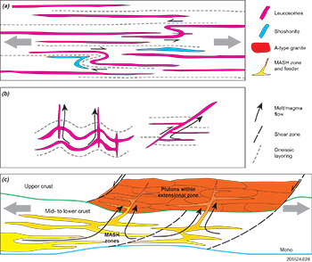
Figure 5 Schematic diagram showing the relation between stress and the geometry of the leucosomes and magmatism. (a) Shallowly dipping leucosomes and foliation develop during the early uniform extension. Shoshonite magmas intrude as sheets aligned parallel to the foliation. Recumbent folds suggest that differential horizontal flow occurred at this time. (b) Shallowly dipping leucosomes are modified during the later stage of deformation. Leucosomes and parallel foliation are folded into upright open structures that have steep axial plane parallel leucosomes. There are reverse faults that represent discordant steeper fluid-filled bodies. Both would facilitate the vertical movement of melt and magma. This figure is not to scale, and the structures occur on the centimetre- to kilometre-scale. (c) Crustal-scale diagram showing the mid to lower to crust MASH zones that are disrupted during the localised extension, causing the magma to mobilise and ascend into the upper crust. Reprinted from Pawley et al. (2020a, fig 11, p 23) under CC BY-NC 4.0.
We propose a 2-stage model for the changing style of deformation and magmatism in the Coompana Province. Early magmatism during extensional deformation was relatively steady state. Pervasive deformation caused small batches of magma to continually migrate from their deeper crustal sources to form the volumetrically minor shoshonite sheets within the migmatitic layering (Fig 5a). The brief change to shortening would have triggered changes in strain within the crust. The restriction of upright folding and reverse faulting to the vicinity of the northeast-trending shear-bounded corridor suggests that shortening was initially focused in the eastern Coompana Province. The localisation of deformation would have created pathways that focused and facilitated melt extraction and transfer (Fig 5b). Once shearing had commenced, the structures became the sites where strain was greatest, leading to increased magma transfer and further partitioning of deformation. Based on the composition of the c. 1150–1140 Ma granite plutons in the corridor, it is proposed that the crustal-scale shearing disrupted the lower crustal MASH (melting, assimilation, storage and homogenisation) zones and formed a conduit that focused magma ascent into the upper crust (Fig 5c). The concentration of the high-temperature magmas within the northeast-trending corridor would also introduce heat and soften the crust, promoting continued failure, leading to feedback between partitioned deformation and magmatism.
Acknowledgements
We acknowledge the Mirning People, and the members of the Far West Coast Aboriginal Corporation, who are the traditional owners of this land and facilitated land access to undertake this program. We would like to thank those involved in long-term discussions of the geology of this region and reviews of the manuscript. We’d also like to thank Anthony Reid of the Geological Survey of South Australia, who reviewed this manuscript. The core used in this study is available for viewing at the South Australia Drill Core Reference Library, Tonsley, South Australia. Funding for the work was provided by the Government of South Australia, with additional funding provided by Geoscience Australia through the Exploring for the Future program.
References
Aitken ARA, Betts PG, Young DA, Blankenship DD, Roberts JL and Siegert MJ 2016. The Australo-Antarctic Columbia to Gondwana transition. Gondwana Research 29(1):136–152. doi:10.1016/j.gr.2014.10.019.
Brown M 1994. The generation, segregation, ascent and emplacement of granite magma: the migmatite-to-crustally-derived granite connection in thickened orogens. Earth-Science Reviews 36(1–2):83–130. doi:10.1016/0012-8252(94)90009-4.
Brown M and Rushmer T 1997. The role of deformation in the movement of granitic melt: views from the laboratory and the field. In Holness MB ed, Deformation-enhanced fluid transport in the Earth's crust and mantle. Chapman & Hall, London, pp 111–144.
Brown M and Solar GS 1998. Granite ascent and emplacement during contractional deformation in convergent orogens. Journal of Structural Geology 20(9–10):1365–1393. doi:10.1016/S0191-8141(98)00074-1.
Camacho A and Fanning CM 1995. Some isotopic constraints on the evolution of the granulite and upper amphibolite facies terranes in the eastern Musgrave Block, central Australia. Precambrian Research 71(1–4):155–181. doi:10.1016/0301-9268(94)00060-5.
Davidson C, Schmid SM and Hollister LS 1994. Role of melt during deformation in the deep crust. Terra Nova 6:133–142. doi:10.1111/j.1365-3121.1994.tb00646.x.
Hartnady MIH, Kirkland CL, Dutch RA, Bodorkos S and Jagodzinski EA 2020. Evaluating zircon initial Hf isotopic composition using a combined SIMS–MC-LASS-ICP-MS approach: a case study from the Coompana Province in South Australia. Chemical Geology 558:119870. doi:10.1016/j.chemgeo.2020.119870.
Kirkland CL, Smithies RH, Spaggiari CV, Wingate MTD, Quentin de Gromard R, Clark C, Gardiner NJ and Belousova EA 2017. Proterozoic crustal evolution of the Eucla basement, Australia: implications for destruction of oceanic crust during emergence of Nuna. Lithos 278–281:427–444. doi:10.1016/j.lithos.2017.01.029.
Kirkland CL, Wingate MTD, Spaggiari CV and Tyler IM 2011. 194773: granitic rock, Eucla No. 1 drillhole, Geochronology Record 1001. Geological Survey of Western Australia, Perth.
Neumann NL and Korsch RJ 2014. SHRIMP U–Pb zircon ages from Kutjara 1 and Mulyawara 1, northwestern South Australia, Record 2014/05. Geoscience Australia, Canberra.
Preiss WV, Korsch RJ and Carr LK 2010. 2008 Gawler Craton-Officer Basin-Musgrave Province-Amadeus Basin (GOMA) seismic survey, 08GA-OM1: geological interpretation of the Officer Basin. In Korsch RJ and Kositcin N eds, GOMA (Gawler Craton-Officer Basin-Musgrave Province-Amadeus Basin) Seismic and MT Workshop 2010, Record 2010/39. Geoscience Australia, Canberra, pp 32–46.
Sandiford M and Hand M 1998. Controls on the locus of intraplate deformation in central Australia. Earth and Planetary Science Letters 162:97–110. doi:10.1016/S0012-821X(98)00159-9.
Sawyer EW, Cesare B and Brown M 2011. When the continental crust melts. Elements 7:229–234. doi:10.2113/gselements.7.4.229.
Smithies RH, Spaggiari CV, Kirkland CL, Wingate MTD and England RN 2015. Forrest Zone: geochemistry and petrogenesis. In Spaggiari CV and Smithies RH eds, Eucla basement stratigraphic drilling results release workshop: extended abstracts, Record 2015/10. Geological Survey of Western Australia, Perth, pp 41–51.
Smits RG, Collins WJ, Hand M, Dutch RA and Payne JL 2014. A Proterozoic Wilson cycle identified by Hf isotopes in central Australia: Implications for the assembly of Proterozoic Australia and Rodinia. Geology 42(3):231–234. doi:10.1130/G35112.1.
Spaggiari CV and Smithies RH eds 2015. Eucla basement stratigraphic drilling results release workshop: extended abstracts, Record 2015/10. Geological Survey of Western Australia, Perth.
Swain GM, Barovich KM, Hand M, Ferris GM and Schwarz MP 2008. Petrogenesis of the St Peter Suite, southern Australia: arc magmatism and Proterozoic crustal growth of the South Australian Craton. Precambrian Research 166(1–4):283–296. doi:10.1016/j.precamres.2007.07.028.
Vanderhaege O and Teyssier C 2001. Partial melting and flow of orogens. Tectonophysics 342(3–4):451–472. doi:10.1016/S0040-1951(01)00175-5.
Vaughan APM and Scarrow JH 2003. K‐rich mantle metasomatism control of localization and initiation of lithospheric strike‐slip faulting. Terra Nova 15(3):163–169. doi:10.1046/j.1365-3121.2003.00485.x.
Vielzeuf D, Clemens JD, Pin C and Moinet E 1990. Granites, granulites, and crustal differentiation. In Vielzeuf D and Vidal P eds, Granulites and crustal evolution. NATO ASI Series (Series C: Mathematical and Physical Sciences), vol 311. Springer, Dordrecht, pp 59–85. doi:10.1007/978-94-009-2055-2_5.
Wade BP, Payne JL, Hand M and Barovich KM 2007. Petrogenesis of ca 1.50 Ga granitic gneiss of the Coompana Block: filling the ‘magmatic gap’ of Mesoproterozoic Australia. Australian Journal of Earth Sciences 54(8):1089–1102. doi:10.1080/08120090701615733.
Weinberg RF, Veveakis E and Regenauer-Lieb K 2015. Compaction-driven melt segregation in migmatites. Geology 43(6):471–474. doi:10.1130/G36562.1.
Wingate MTD, Kirkland CL, Spaggiari CV and Smithies RH 2015. U-Pb geochronology of the Forrest Zone of the Coompana Province. In Spaggiari CV and Smithies RH eds, Eucla basement stratigraphic drilling results release workshop: extended abstracts, Record 2015/10. Geological Survey of Western Australia, Perth, pp 37–40.


