Gawler Craton Airborne Survey flying completed.
June 2019 saw the completion of acquisition of aerial data for the Gawler Craton Airborne Survey (GCAS), the largest and highest quality government airborne geophysical and terrain imaging program in South Australia’s history. Covering some 294,000 km2, or about the area of Italy, the $10 million survey took in sections of the Woomera Prohibited Area and captured 1.67 million line kilometres of data, equal to circling the equator 41 times. Data recording commenced in January 2017.
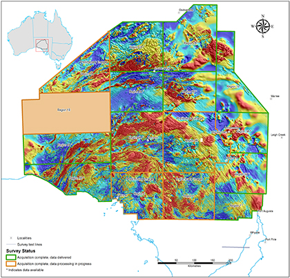
Sixty-five percent of the GCAS data has already been processed and released – 190,000 km2 of new high-quality precompetitive magnetic, radiometric and terrain data made public. All the data is expected to be released over the next few months. Figure 1 shows the GCAS regions available to date along with preliminary images of blocks near processing completion and those still undergoing processing.
In addition to the data releases, the Department for Energy and Mining (DEM) has partnered with CSIRO to provide a comprehensive suite of value-added data products derived from the GCAS data. These products include filtered magnetic images and magnetic modelling that predicts the depth to economic rocks below the surface. To date, these value-added releases have provided new information and data across some 109,000 km2. All of the data are available via SARIG and the Gawler Craton Airborne Survey community information webpage.
GCAS has set new standards across a range of benchmarks from data capture and delivery formats through to landholder communications, community information and data delivery.
Since the survey began, there have been more than 28,000 views of GCAS data on the webpage and over 2,200 data downloads – 1,672 of new survey data and 536 of value-added and depth model data packages.
DEM would like to thank and congratulate the airborne geophysics suppliers and contractors to GCAS: MagSpec Airborne Surveys Pty Ltd, Sander Geophysics, Thomson Aviation Airborne Geophysical and Survey, GPX Surveys, Baigent Geosciences and Minty Geophysics. The cooperation of the Department of Defence and the assistance of collaborative partners Geoscience Australia and CSIRO is also gratefully acknowledged.
Supporting exploration
GCAS has provided a high-quality, seamless foundation dataset for mineral exploration of the Gawler Craton. Airborne magnetic and radiometric data are key tools for directly detecting the signatures of ore-forming systems. The data are also used in mapping the surface and subsurface geology, particularly in areas with extensive cover sediments and regolith such as the northern Gawler Craton.
The Gawler Craton is South Australia’s most well-endowed minerals asset; 45% of the land within the GCAS area is currently occupied by minerals exploration licences and exploration licence applications. It is a world-class iron oxide – copper–gold province hosting the copper-rich Olympic Dam, Prominent Hill and Carrapateena deposits, the Challenger gold deposit, and iron ore deposits of the Middleback Range. Geologically younger sediments overlying the Gawler Craton host the giant Jacinth-Ambrosia heavy mineral sand deposits which are major sources of titanium and zirconium.
– Laz Katona, August 2019


