SARIG’s latest tool provides easy access to geophysical data.
A timeslice tool enabling viewing of geophysical survey data in five-year intervals has been added to the Map Layers Catalog in SARIG, the South Australian Resources Information Gateway.
Of the thousands of geophysical surveys acquired over South Australia, many hundreds are airborne surveys, notably magnetic, radiometric and electromagnetic. SARIG has traditionally displayed the airborne survey boundaries on a single map layer. Overlapping boundaries made the map difficult to interpret, especially when used in conjunction with other layers - eg Mineral Tenements or Geology. Recognising the need for a more user-friendly tool, the Geological Survey of South Australia’s geophysics team developed timeslice layers.
To view the new functionality:
- Open SARIG and click on ‘All Map Layers’ in the lower left-hand-side of the screen.
- Start typing ‘geophysical’ in the input box and the timeslice option will appear underneath.
- Click the tick box next to ‘Geophysical Surveys’ and the map window will populate with all of the airborne geophysical surveys boundaries currently on SARIG.
- Click on ‘Active Layers’ in the top left-hand-side of the screen and next to the Timeslice option you should see a little clock icon.
- Left-click on the little clock and the map will default to displaying available surveys from the latest five years.
- To change the visible surveys on display use the slide bar underneath. The surveys are grouped into five-year intervals.
Figure 1 shows an example of the timeslice set at 2014 to 2019.

Figure 1 Timeslice airborne geophysical surveys acquired in South Australia between 2014 and 2019.
Alerts to recent additions
While all geophysical surveys reported in open file company exploration reports are available via SARIG’s Georeference catalogue, they may not appear as a layer on SARIG yet. Historical and more recent survey data are routinely added with airborne geophysics then ground gravity the priority. Recent additions are now displayed in a new section added to the ‘Exploration data releases’ page of this MESA Journal and will be updated regularly.
Downloading survey data and grids
There are four main ways to download geophysical survey data from SARIG. For options 1 to 3, first select Geophysical Surveys as an active layer.
- Using the ‘Spatial Search’ option, select ‘Active layers’ from the drop-down menu.
Use the ‘Draw Area’ tool to draw a box on the survey you’re interested in and a pop-up window will emerge from the bottom of the screen that includes a link to the survey data and metadata (Fig. 2).
Surveys downloaded using this option will contain all of the company supplied and Geological Survey processed data, grids and contractor reports in a single download. - Using the ‘Spatial Search’ option, select ‘Geophysical data’ from the drop-down menu.
Again, draw a box in your area of interest, but this time click the Advanced Search option at the bottom-left of the screen and follow the prompts.
This method cookie-cuts the survey to the box you drew on the screen and has options for downloading multiple types of geophysical data in either grid or located data (ASCII format) for multiple surveys in your choice of coordinate system and datum. - From the ‘Action’ option in the middle of the screen, select the ‘Identify’ tool.
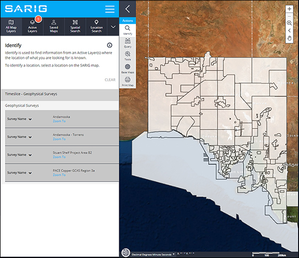
Click on the map at your area of interest and any surveys intersecting the clicked area will be listed on the left-hand-side of the screen (Fig. 3).
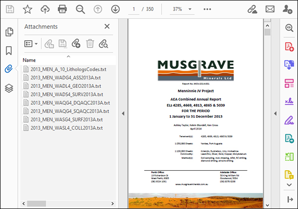
Expanding any of these items will reveal a hyperlink that will allow you to directly download the complete data package for that survey. - If you can’t find a survey you know exists – or see no surveys in your area of interest – be sure to check any open file company mineral exploration envelopes in that area. One way to do this is to identify previous exploration licences in your area of interest using SARIG. Then click the burger menu in SARIG (the three horizontal lines near the top) and select ‘Georeference’. Under ‘Mineral company exploration reports’, click on ‘Advanced search’, and type the exploration licence number next to ‘Tenements’ – eg EL05039. The results page displays links to open file envelopes. Many smaller surveys – including gravity and ground magnetics – are often paper clipped to the PDF and have not yet made it to the spatial layers (Fig. 4).

Figure 2 Accessing geophysical survey data using the ‘Active layers’ dropdown menu.

Figure 3 Accessing geophysical survey data using the ‘Identify’ tool.

Figure 4 Example company mineral exploration report showing raw data files paper clipped to the PDF.
Surveys are also available on GeoNet via Amazon Web Services (AWS). The survey data packages downloaded via AWS can’t be cookie-cut to size, but they do contain original data as supplied by the contractor and provide access to an entire survey and metadata via a single URL.
For assistance with downloading geophysical data from SARIG email Customer Services DEM.CustomerServices@sa.gov.au
– Philip Heath, Jonathan Irvine and Laz Katona, July 2020


