
Surface geochemistry data captured in the Delamerian region.
All legacy geochemical surface sample data has been compiled from company exploration reports across the Quondong Vale area in the northern half of the Delamerian National Drilling Initiative (NDI) region (Fig 1). This capture of data complements the drilling program scheduled to start mid 2021 – a partnership between the Geological Survey of South Australia (GSSA) and MinEx CRC.

Figure 1 Surface samples with geochemistry captured and collated around the Quondong Vale NDI area, overlain on ternary radiometric data (red = K%, blue = U eppm, green = Th eppm). A large alluvial fan system is evident across the centre of the Quondong Vale NDI area.
Surface geochemistry data is used to look for evidence of possible buried mineralisation. When coupled with surface landform mapping, it also helps to understand the provenance of sedimentary material at the surface. Together with recent advances in biological sampling analyses, these low-impact (green) techniques provide a window into the subsurface as we advance our understanding of the cover and its interaction with older, typically crystalline, basement.
An additional 3,243 surface samples with geochemistry were added to SA Geodata and are now available via the South Australian Resources Information Gateway (SARIG). This brings the total number of surface samples with geochemistry across the northern region of the Delamerian NDI area to about 28,485; an increase of 11% in available data equating to around $324,300. The range of sampling material captured includes soil, stream sediments, near surface auger soil and calcrete, gravel, and rock outcrop or float. The analyses were conducted across 11 different laboratories and encompass work undertaken from 1970 to around 2016.
The surface samples are distributed around areas of outcropping geology and the very shallow margins of the Murray Basin. The stream sediment data captured through the Olary Ranges (Fig 1), which represents a catchment area over 400 km2 with multiple mineral occurrences, may give an indication of what could be found across the broad alluvial fan system evident in the ternary radiometric data across the region.
Delving deeper
A subset of the soil survey data captured for the Quondong Vale area was investigated with the aim to better understand how a soil sampling program could be applied to identify features through cover. One of the findings was the suggestion that there may be a relationship between basement faults and geochemistry of soil samples. This relationship between soil geochemistry and the landform settings has also been investigated from remote sensing (satellite) data across the focus area. These learnings are being applied in planning for GSSA’s broader geoscience program around the NDI drilling campaign. A report with more detail will be published soon.
The potential to use biogeochemistry as a low impact tool for exploration activities in areas of deeper cover was also examined. Utilising the NatureMaps produced by the Department for Environment and Water it is possible to identify plant species across the region that are both widespread, deep rooted (often tens of metres) and long lived – an adaption to living in arid environments. Black Sheoak (Casuarina pauper) and White Mallee (Eucalyptus gracilis) trees are an ideal sampling medium with deep taproots that act as a ‘pumping station or conduit’ of the subsurface geochemistry. These plants bypass the limitations that can arise from lateral-derived sediments (e.g. the broad alluvial fan system evident in the radiometric data in Fig 1) when utilising more traditional surface exploration methods. Tree roots not only sample the groundwater interacting with the underlying basement but also uptake soil water throughout the cover that has interacted with other areas of enrichment brought about during the differential weathering of the cover through its evolution (Fig 2).
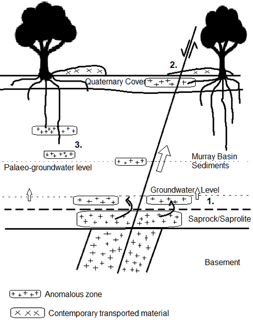
Figure 2 Schematic diagram demonstrating the differential weathering through the cover and the formation of anomalous zones. 1. Formation of anomalies at the groundwater boundary. 2. Movement of fluid along fault structures can form anomalies through the cover at paleogroundwater tables throughout the cover and at the surface within the Quaternary cover. 3. These anomalies can be tapped by the trees to reflect anomalies at depth, but also those formed at the surface by faults that could otherwise be obscured contemporary transported material (2).
Complementing the upcoming drilling in the Quondong Vale area, will be geochemical sampling of cover material and a possible biogeochemical survey. The results will help further characterise the cover and deepen understanding of the relationship between surface and basement. The use of these low impact tools for mineral exploration will provide explorers with a range of datasets that can be interrogated to build mineral prospectivity models for this region.
– Charlotte Mitchell and Anna Petts, April 2021