
Full title:
Extending the Warakurna Supersuite into southern Australia
MJ Pawley1, TW Wise1, EA Jagodzinski1 and RA Dutch1,2
1 Geological Survey of South Australia, Department for Energy and Mining
2 Datarock, Level 3, 31 Queen Street, Melbourne, Victoria 3000
Download this article (PDF 5.5 MB)
Published January 2025
Introduction
Extensive mafic magmatism occurred across central and western Australia during the late Proterozoic, increasing the Cu-Ni-PGE-Au potential of these areas through the significant influx of mantle magma and heat into the crust. One of the main contributors of mantle-derived magmatism in this region was the c. 1085–1040 Ma Giles Event (Howard et al., 2011; Maier et al., 2014; Sun et al., 1996). This was a long-lived igneous event that is largely localised to the western and central Musgrave Province (Fig. 1). The Giles Event includes bimodal extrusive and intrusive rocks. The extrusive volcanic rocks form the Bentley Supergroup in the western Musgrave Province, while the intrusive mafic–felsic rocks of the Warakurna Supersuite largely intruded into the western and central Musgrave Province (Evins et al., 2010; Howard et al., 2011). The exception is the c. 1075 Ma Warakurna Large Igneous Province (LIP: Fig. 1), which represents a short-lived period of mantle-derived magmatism that has been recorded across large parts of central and western Australia (Wingate et al., 2004). Intrusive mafic rocks of the Warakurna LIP were traced from the eastern Musgrave Province and the southern Arunta Block in the east, westwards to the northwest Yilgarn Craton and western Capricorn Orogen (Wingate et al., 2004).
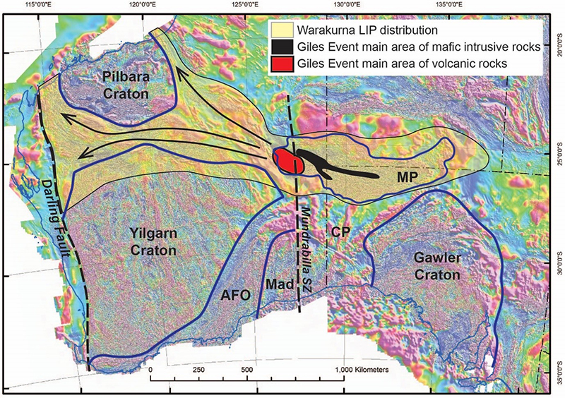
Figure 1 Reduction to pole aeromagnetic image of southwestern Australia showing the distribution of the c. 1075 Ma igneous rocks, and the interpreted extent of the Warakurna LIP, and main rocks of the Giles Event. The black dashed lines are major shears and faults, blue lines are major crustal boundaries, and the black arrows show the flow of the Warakurna LIP to the west. Modified from Smithies et al. (2015a). MP = Musgrave Province, CP = Coompana Province, AFO = Albany Fraser Orogen, Mad = Madura Province.
Wingate et al. (2004) interpreted the Warakurna LIP to be the result of a mantle plume. However, the extended magmatism of the broader Giles Event led to alternative models. It has been proposed that the long time span of the Giles Event represented the continuation of the high-T Musgravian Orogeny, with fixed, long-lived mantle upwelling under the region (Smithies et al., 2011; Smithies et al., 2015a). Alghamdi et al. (2018) proposed that magmatism was focused into zones of thinner crust between the West Australian and South Australian cratons, resulting in underplates that subsequently increased the Ni-Cu-PGE mineralisation potential of the region. Within this framework, it was proposed that this extremely hot magmatic system was disrupted by movement along the crustal-scale Mundrabilla Shear Zone with two consequences (Smithies et al., 2015a). First, movement on the shear destabilised the thermal anomaly under the western Musgrave Province triggering the magmatism associated with the Warakurna LIP. Second, movement juxtaposed the Musgrave Province with the eastern end of the Capricorn and Paterson orogens where pre-existing orogen-scale extensional structures channelled magma flow to the west (Fig. 1).
The Giles Event is important for economic mineral potential. The event involved intrusion of the large Giles Complex that hosts the Nebo-Babel, Succoth, and Wingellina Hills deposits, and the Jameson prospect in the western Musgrave Province (e.g. Glikson et al., 1996; Godel et al., 2011; Maier et al., 2014; Seat et al., 2007). The Giles Complex intrusions in the eastern Musgrave Province have also been explored for Ni-Cu-Co sulphide mineralisation (e.g. Craton Resources NL, 1999). Secondary nickel concentration has also been reported in laterites that developed over olivine-rich ultramafics (Woodhouse and Gum, 2003). Consequently, understanding the extent and controls on the Giles Event and Warakurna LIP will help to understand the extent of the associated mineralisation systems and potentially unlock areas for new exploration targeting.
In South Australia, rocks of the Warakurna Supersuite were originally interpreted to be largely restricted to the Musgrave Province (Fig. 1: Wingate et al., 2004), with no evidence for c. 1075 Ma magmatism outside this area. The Coompana Province, located between the South Australian and West Australian cratons (Fig. 1), contains a series of remanently magnetised bodies that had been intersected during earlier company drilling and found to comprise mafic rocks, but they were temporally and compositionally poorly constrained (Wise et al., 2015).
A large body of new work was collected in the area by the Geological Survey of South Australia (GSSA), in collaboration with Geoscience Australia. In 2015 the Coompana Magnetic and Radiometric survey was flown, increasing the magnetic line density to between 400 m and 200 m (Heath et al., 2015). This allowed a greater level of interpretation of the geology of the Coompana Province (Wise et al., 2015, 2018b). In 2017 GSSA undertook a drilling campaign to help understand the basement geology of the eastern Coompana Domain. The campaign drilled eight holes targeting distinctive geophysical domains in the basement under the Eucla Basin, intersecting migmatitic orthogneisses, megacrystic granites, massive mafic intrusive rocks corresponding to the remanently magnetised bodies, and basalts. Based on geochronology and geochemistry, the remanently magnetised mafic rocks were assigned to the Warakurna LIP (Fig. 2: Dutch et al., 2018; Jagodzinski et al., 2019).
The results of this drilling campaign revealed two main findings about the Warakurna LIP. First, the mafic magmatic rocks contemporaneous with the Warakurna LIP can be traced to the southern coast of Australia. Second, the distribution of the mafic rocks near the southern coast suggests the southern extension of magmatism was structurally controlled.
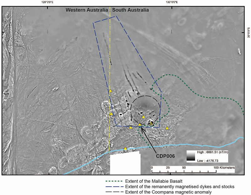
Figure 2 1VD TMI image of southern Coompana Province showing the remanently magnetised mafic bodies. The northeast-trending corridor of elliptical magnetic bodies corresponds to c. 1160 Ma granite plutons in the footwall of the northwest dipping Palinar Shear Zone (Pawley et al., 2018a). The linear north-trending demagnetised feature at the western edge of the figure is the Mundrabilla Shear Zone. The yellow triangles are the drill sites from the GSSA’s Coompana drilling campaign. The blue line is the coast, and the yellow dash-dot line is the border.
Regional geology of the eastern Coompana Province
The geological evolution of the basement of the eastern Coompana Province in South Australia can be divided into two main geodynamic stages (Wise et al., 2018a). These stages are summarised in this section, and for more detail, the reader is referred to Dutch et al. (2018) and Wise et al. (2018a).
The first major stage of geological evolution involved prolonged cyclic arc–subduction, which is interpreted to have consumed an oceanic crust dating back to c. 2000–1900 Ma (Hartnady et al., 2018; Kirkland et al., 2017). The oldest dated rocks are the c. 1618 Ma migmatitic orthogneisses of the Koomalboogurra Suite of the Toolgana Supersuite (Jagodzinski et al., 2019; Wingate et al., 2015). The Koomalboogurra Suite is interpreted to represent subduction-related granites that developed on the edge, or outboard of the Gawler Craton (Dutch et al., 2016; Swain et al., 2008). The c. 1526 Ma migmatitic orthogneisses of the Bunburra Suite have primitive geochemical signatures and juvenile isotopic character, indicating the rocks were derived from a subduction-enriched lithospheric mantle source (Dutch, 2018).
The c. 1505 Ma Gilgerabbie Suite in the eastern Coompana Province (Wade et al., 2007) is part of the c. 1505–1487 Ma A-type Undawidgi Supersuite that was recognised in the western Coompana Province (Wingate et al., 2015). These rocks are interpreted to be the product of intracontinental extension (Smithies et al., 2015b) following cessation of c. 1526 Ma subduction.
The second stage of geological evolution involved major intracontinental melting and magmatism between c. 1200 and 1070 Ma. This can be divided into two stages of intraplate magmatism that resulted in two compositionally distinct magmatic suites (Wise et al., 2018a). The first stage at c. 1174–1140 Ma generated the mafic–intermediate Merdayerrah Shoshonite and felsic Koonalda Suite (Pawley et al., 2020; Wise et al., 2018a). These suites have relatively juvenile ɛHf 1174–1140 Ma values, suggesting little or no assimilation of any pre-1900 Ma crust. Instead, they appear to be derived from mantle input and the assimilation of crust like the older Bunburra and Koomalboogurra suites (Dutch, 2018).
The second stage of intraplate magmatism generated mafic rocks (Wise et al., 2018a). The mafic rocks are unexposed but have been intercepted in numerous drillholes. Furthermore, they form remanently magnetised plugs, sills and dykes and extrusive basalt flows, allowing their distribution and geometries to be recognised on aeromagnetic datasets. A high-level fractionated olivine dolerite intercepted in drillhole CDP002 has been dated at 1074 ± 6 Ma (Jagodzinski et al., 2019). This indicates the remanently magnetised mafic rocks were contemporaneous with the mafic-ultramafic Warakurna Supersuite in the Musgrave Province (Howard et al., 2011; Sun et al., 1996), and the broader Warakurna LIP (Wingate et al., 2004). The mafic rocks can be divided into two suites, the Giants Head and Warbla suites, which have distinctive mineralogy, geochemistry, and isotopic compositions (Dutch, 2018; Jagodzinski et al., 2019; Pawley et al., 2020; Wise et al., 2018a). These two mafic rock suites are the focus of this paper as they have implications for the Proterozoic history and mineral potential of southern Australia and will be described in more detail in the next section.
Results
C. 1075 Ma mafic rocks of the Coompana Province
The c. 1075 Ma mafic rocks of the Coompana Province intersected during the GSSA’s drilling campaign in 2017 have been divided into two suites (Dutch et al., 2018). These are the olivine-bearing Giants Head Suite and olivine-absent Warbla Suite (Dutch, 2018; Jagodzinski et al., 2019; Pawley et al., 2020; Wise et al., 2018a).
Giants Head Suite (olivine-bearing)
Lithology
The Giants Head Suite comprises three main phases; dolerite, undivided basalts and the Mallabie Basalt (Pawley et al., 2020).
The dominant phase is undivided texturally variable dolerite, which ranges from dark green to pale grey, fine- to coarse-grained, and equigranular to porphyritic. The dolerite is characterised by large interlocking plagioclase laths in a fine- to medium-grained groundmass of clinopyroxene, olivine (now replaced by actinolite and opaques), amphibole, and fine-grained mesostasis (Fig. 3a-d: Mason, 2018). The texturally different dolerites are interlayered with irregular, gradational contacts, and likely represent textural variation as the mafic intrusive body crystallised and evolved. The dolerite has local pervasive sericite and hematite alteration and is also locally cut by sets of carbonate veins that are up to 5 mm thick.
The orthogneisses of the Koomalboogurra Suite and granitic rocks of the Koonalda Suite are intruded by minor undivided basalts that are assigned to the Giants Head Suite, based on mineralogy and field relations. The undivided basalts are dark grey, massive, and aphyric (Fig. 3e). The basalts have abundant plagioclase laths and chlorite (after the primary ferromagnesian phase), with mesostasis comprising quenched bladed clinopyroxene and magnetite (Mason, 2018).
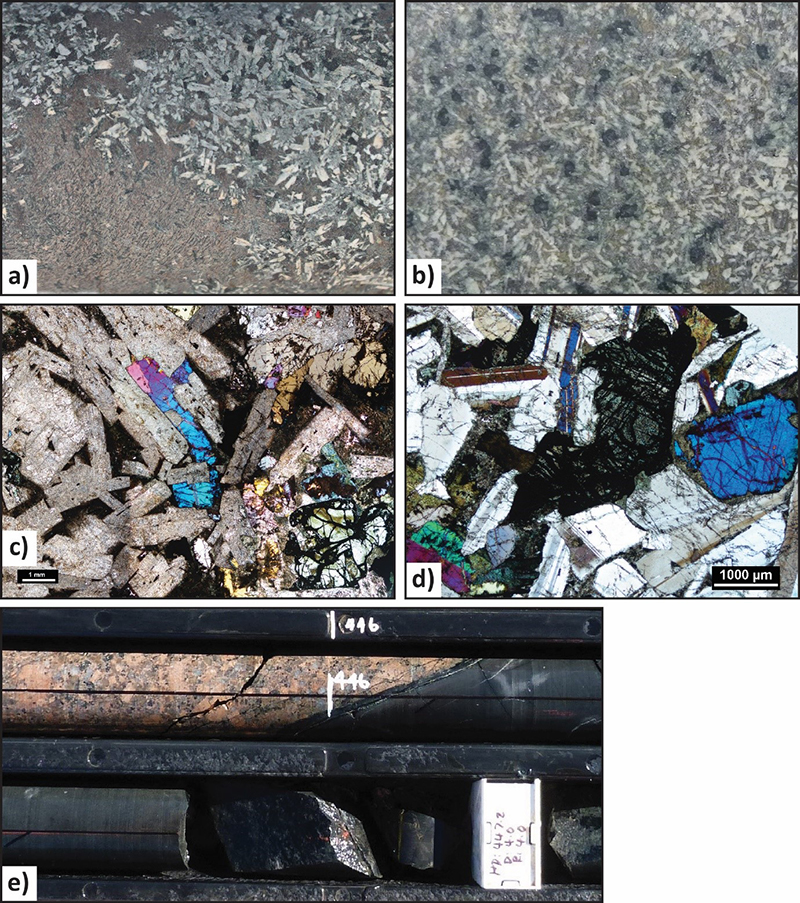
Figure 3 Core photographs and photomicrographs of the undivided plutons of the Giants Head Suite. a) Core photograph of the doleritic phase from CDP002 (468.9 m) showing the ophitic texture, with a large patch of fine-grained mesostasis in the lower left of the photograph (field of view is ~3 cm across; photo 418147). b) Core photograph of the more equigranular dolerite from CDP002 (426.9–430.6 m) showing the large blocky olivine surrounded by plagioclase and clinopyroxene (field of view is ~3 cm across; photo 418148). c) Photomicrograph of the dolerite (thin section 2430064A, under cross-polars), showing the plagioclase laths (now sericite-altered) with interstitial clinopyroxene, olivine and mesostasis (photo 418149). d) Photomicrograph of the more equigranular dolerite (thin section 2430074, under cross-polars), showing the olivine (now altered to actinolite and opaque minerals) and clinopyroxene surrounded by subhedral plagioclase laths (photo 418150). e) Core photograph from CDP003 of the basalt of the Giants Head Suite intruding granite of the Koonalda Suite (~446 m; photo 418151).
The Mallabie Basalt is a formal unit within the Giants Head Suite that contains three main extrusive rock types; basalt, brecciated basalt and a volcaniclastic unit (Pawley et al., 2020).
The basalts are dark brown-green, massive, fine- to medium-grained and variably vesicular to amygdaloidal (Fig. 4). The rocks are generally equigranular with the occasional porphyritic interval with ~5 mm long plagioclase laths. The amygdales generally occur throughout the flows (not just at the flow tops) and have two main forms: larger (~10 mm) zoned quartz–calcite-filled amygdales; and smaller (~3–10 mm) dark green amygdales that are likely chlorite-filled (Dutch et al., 2017c). Carbonate, sericite, and hematite alteration is common throughout the rock.
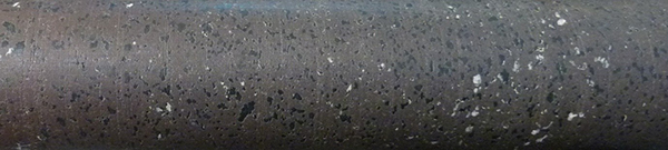
Figure 4 Amygdaloidal basalt from CDP008 showing the vesicles filled by chlorite and carbonate (600.0 m; photo 418152).
The brecciated basalts are interpreted to be flow tops and have angular basalt clasts suspended in a very fine grained, hematite-rich, red siltstone matrix. The basalt fragments have chlorite and hematite alteration (Mason, 2018). The brecciated rocks have common carbonate infill and veining (Dutch et al., 2017c).
The volcaniclastic rocks are a minor phase that occur at the top of the Mallabie Basalt in CDP008, directly below the unconformity. These rocks are epiclastic, fine-grained, laminated, and dark-red-brown in colour (Dutch et al., 2017c).
Whole rock geochemistry and isotopic composition
Geochemically, the rocks of the Giants Head Suite have a silica range between 45.5–54.4 wt% SiO2 (Dutch, 2018). These units display slight increasing trends in TiO2, K2O, Fe2O3 and P2O5, with flat to slightly increasing Na2O and decreasing Al2O3, MgO and CaO with decreasing Mg#. They are elevated in Al2O3 (>13.5 wt%) and MgO (4.9–10.6 wt%) with slightly lower Fe2O3 T (8.1–16 wt%) and correspondingly higher Mg# (41–62) and are depleted in TiO2 (<1.67 wt%) and P2O5 (<0.3 wt%) compared to the two-pyroxene basalts of the Warbla Suite (Dutch, 2018). The basalts show scattered to decreasing trends in Ni (<241 ppm), Cr (<160 ppm) and Co (<67.5 ppm) with decreasing Mg#. Samples of the Mallabie Basalt from CDP008 contain 5–15 ppb Au.
Isotopically, these mafic rocks range from relatively primitive to evolved and fractionated units with enriched large ion lithophile elements (LILE) and high-field strength elements (HFSE) compared with a MORB source and have incompatible trace element patterns typical of crustal contamination (Dutch, 2018). The most primitive samples are also isotopically juvenile, consistent with a juvenile mantle source. The more fractionated/contaminated samples have distinctly more evolved isotopic signatures, with εNd1070 Ma as low as -11.21, corresponding to DM model ages of up to 3.05 Ga. This is more evolved than any sampled basement in the Coompana Province and requires a non-radiogenic input and suggests crustal contamination by evolved Archaean crust, potentially in a deep crust-mantle boundary magma chamber (Dutch, 2018).
Warbla Suite (olivine-absent)
Lithology
The Warbla Suite comprises pyroxene-bearing (olivine-absent) volcanic to subvolcanic rocks. These include dark grey, fine- to medium-grained, massive and inequigranular to weakly porphyritic basalts and dolerites (Fig. 5). The rocks contain plagioclase, clinopyroxene and opaque mineral phenocrysts in a groundmass of mesostasis comprising feldspar, clinopyroxene and opaque minerals (Mason, 2018). The basalt is homogeneous, but it is locally finer grained and more equigranular.
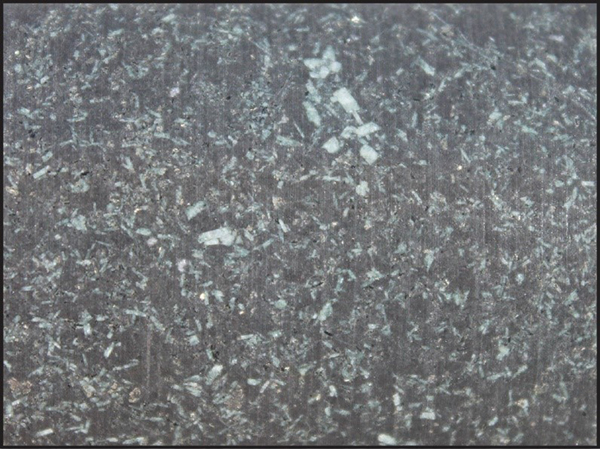
Figure 5 Core photograph of the porphyritic Warbla Suite in CDP007 (286.0 m) showing the fine feldspar phenocrysts. (Field of view is ~3 cm wide; photo 418155).
Whole rock geochemistry and isotopic composition
Geochemically, the two-pyroxene basalts have elevated SiO2 (54.6–57.02 wt%) and are geochemically classed as a basaltic trachyandesite (LeMaitre, 1989). They display a restricted range of compositions with distinct comparative enrichments in Fe2O3 T (15–17.7 wt%), TiO2 (1.55–1.8 wt%) and P2O5 (0.4–0.52 wt%). The rocks are depleted in Al2O3 (11–13 wt%) and have very low MgO (<3.3 wt%) with Mg# between 15–30 (Dutch, 2018).
The basalts show scattered to decreasing trends in Ni (<241 ppm), Cr (<160 ppm) and Co (<67.5 ppm) with decreasing Mg#. The two-pyroxene basalts in BN1 and 2 (Fig. 6) have elevated Cu (249–315 ppm) compared to all other samples while the CDP008 basalts contain 5–15 ppb Au. A single sample from CDP002 (2430066) contains elevated Pt (25 ppb) and Pd (67 ppb) (Dutch, 2018).
Isotopically, the two-pyroxene basalts of the Warbla Suite are enriched suggesting a lithospheric mantle source that includes remnants of the enriched source that produced the Merdayerrah shoshonites (Dutch, 2018). This suggests that the subcontinental lithospheric mantle (SCLM) beneath the Coompana Province is heterogeneous, and the 1074 Ma mafic rocks were sourced from an enriched mantle not completely depleted or eroded by the voluminous lithospheric melting associated with the Koonalda Suite high-K-Fe A-type granites.
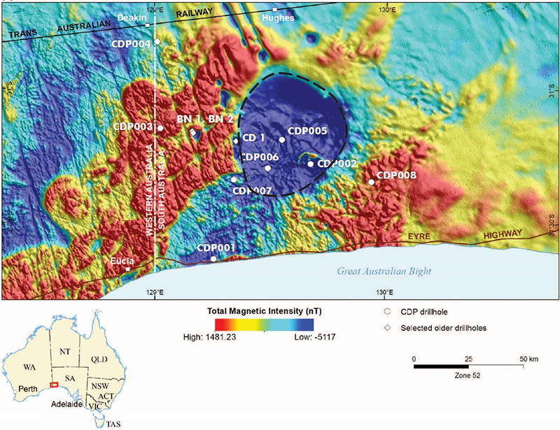
Figure 6 Location of the Coompana Drilling Project drillholes (with ‘CDP’ prefix) and previous basement intersecting diamond drillholes, shown over the reduction to pole TMI image. The black dashed line shows the extent of the Coompana magnetic anomaly.
Distribution of the c. 1075 Ma mafic rocks
The rocks of the Giants Head Suite are not exposed and have only been intersected in drillholes. However, the mafic rocks are remanently magnetised and are prominent features on aeromagnetic images, allowing their distribution and geometry to be mapped. The rocks of the Giants Head Suite that have been intersected in drillholes form three main igneous features that are widespread across the southwestern part of South Australia (Pawley et al., 2020; Wise et al., 2018b). These include (Figs 2 and 6):
A series of circular to ovoidal intrusions that are up to 10 km across. A larger circular stock was intersected by drillhole CDP002, and dated at c. 1075 Ma (Fig. 6: Dutch et al., 2017a; Jagodzinski et al., 2019).
Massive, aphyric, olivine-bearing basalt sheets that intrude megacrystic granite of the Koonalda Suitein drillhole CDP003 (Fig. 3e) and migmatitic rocks of the Koomalboogurra Suite in drillhole CDP006 (Dutch et al., 2017b). These sheets are approximately 2 m wide.
Extrusive rocks assigned to the Mallabie Basalt (a sub-unit of the Giants Head Suite) were intercepted in drillholes CDP008, Mallabie 1, CD 1, and KN1 (Dutch et al., 2017c; Pawley et al., 2020), allowing the wide extent of this unit to be determined. On aeromagnetic images, the volcanic rocks appear to produce a stippled texture which suggests that the unit is preserved in two main areas (Fig. 6: Wise et al., 2018a; Wise et al., 2018b). The first area, and main body of volcanic rocks occurs in an irregular shape with lobate margins that extends westwards from near the Mallabie 1 drillhole for ~100 km, and northwards from the coastline for ~100 km. A second smaller area of basalt flows was intercepted in drillhole CD 1. This area is elliptical in shape and ~10 by 5 km in extent, with the long axis aligned north–south. This area coincides with a remanently magnetised body that may represent a subvolcanic intrusion.
The Warbla Suite is not exposed, but has been recognised in drillholes CDP007, BN 1 and BN 2, where the rocks are observed as small stocks (Fig. 6: Wise et al., 2018b). The location of CDP007 corresponds to a small, remanently magnetic intrusive body that is <1 km long by <0.5 km wide, with the long axis aligned in a north–south orientation. The rocks intersected in drillholes BN 1 and BN 2 also correspond to a weakly elongate remanently magnetised body that is ~2 by 3 km in extent, with the long dimension oriented east-northeast.
The Coompana Province also contains two other igneous bodies that are interpreted as part of the Warakurna Supersuite based on their remanent magnetism and distribution, despite not being intercepted in any drillholes. These include:
The large (~40 km diameter), circular, remanently magnetised Coompana magnetic anomaly (Figs 2 and 6: Wise et al., 2015, 2018b), which has been assigned as part of the Giants Head Suite despite being untested (Pawley et al., 2020). This is assigned because of observations that the large, deep body underlies higher-level intrusions that are part of the Giants Head Suite, suggesting the large anomaly may represent a deeper magma chamber.
There are a series of remanently magnetised sheets that extend to the north-northwest for over 150 km from the area of intrusions described above (Figs 2 and 6: Wise et al., 2018b). The sheets appear to intrude parallel to a series of faults and joints that are represented on the aeromagnetic images as north-northwest-trending, anastomosing, thin demagnetised zones.
Structural geology and alteration
The rocks of the Warakurna Supersuite intersected in drillholes within the southern Coompana Province are observed to be cut by several sets of veins and overprinted by several stages of alteration.
The Koomalboogurra Suite migmatitic gneisses intersected in the CDP006 drill core are cut by sheets of very-fine-grained, black to dark green basalt interpreted to be part of the Giants Head Suite (Pawley et al., 2018b). The basalt often forms sheets that sharply cut the gneissic layering, but also forms the groundmass to breccias along the contacts of the sheets. The basalt has a locally preserved massive igneous texture.
The rocks in the CDP006 drillhole have been extensively modified by alteration (Pawley et al., 2018b). In the basalt, plagioclase laths have been replaced by sericite and the aphanitic groundmass altered to chlorite, hematite ± carbonate. In places, the basalts are brecciated with an albite, quartz, and chlorite cement. In the Koomalboogurra Suite migmatitic gneisses, plagioclase has been replaced by albite and sericite, ferromagnesian minerals have been replaced by chlorite and minor epidote, and K-feldspar and secondary albite have been clouded by hematite. The chlorite alteration is locally intense in the migmatitic gneisses, producing a black, very fine-grained to aphanitic metasomatic rock that locally contains common irregular, elongate, rounded pieces of quartz and feldspar that are interpreted to represent remnants of the original migmatitic layering.
The migmatitic gneisses and basalt are cut by several styles of veining (Pawley et al., 2018b). White quartz forms veins up to 10 cm-wide, which cut the intensely chlorite-altered rocks. The quartz also forms patches and vein networks that isolate angular blocks of the altered host rocks. Later stage calcite and quartz veins cut the rocks in CDP006 drill core. These zones are often aligned sub-parallel to the sub-vertical core, suggesting they are steep structures. A cm-scale west-dipping vein in a basalt dyke forms a sinuous calcite-filled jog that suggests a west-side down sense of movement (Fig. 7a), indicating an extensional feature. Locally developed breccia zones have a calcite-bearing groundmass. There are also minor epidote, sericite, and hematite veins. These veins are generally discrete, sharp-edged, are millimetres wide, and often have a halo of bleached, altered rock. The epidote veins also form sharp-edged, angular, west-dipping jogs (Fig. 7b) that also indicate west-directed extension.
The veins occur in two main orientations (Fig. 7c: Pawley et al., 2018b). The main trend is northeast-striking with most veins steeply to moderately dipping to the southeast, sub-parallel to the trend of the Palinar Shear Zone in this area. This suggests veining occurred during formation or reactivation of this structure. There are also north-striking veins that dip moderately to the east and west. The west-dipping extensional calcite and epidote-filled veins (Fig. 7) suggest there was a component of east-west-directed extension during the veining event.
The observations from the CDP006 drill core suggest that the alteration and veining was contemporaneous with regional deformation and occurred either during, or after intrusion of the Warakurna Supersuite mafic rocks.
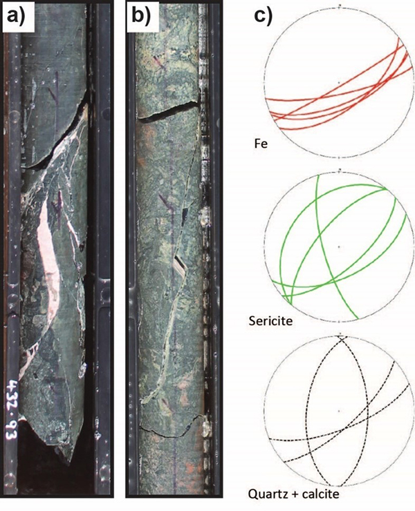
Figure 7 a) Core photograph of a sinuous extensional calcite-filled jog on a steeply west-dipping vein in chlorite-altered basalt of the Giants Head Suite (CDP006 depth ~432.93 m). b) Core photograph of an extensional epidote-filled jog on a steeply west-dipping vein in epidote-altered migmatitic gneiss (CDP006 depth ~414.8 m). c) Stereonets of the veins measured in CDP006. The veins are divided based on composition (hematite n = 5), sericite n = 5, quartz and calcite n = 4).
Discussion
Expanding the Warakurna LIP
The results of the drilling indicate that mafic rocks, contemporaneous with the Warakurna LIP and assigned to the Warakurna Supersuite (Jagodzinski et al., 2019; Pawley et al., 2020; Wise et al., 2018b), are common in the southwest corner of South Australia. These rocks form remanently magnetised bodies, including plutons, stocks, sheets, and lava flows (Fig. 6). There is also a deep ~40 km diameter, remanently magnetised body labelled as the Coompana Magnetic Anomaly, which is interpreted to be part of the Warakurna Supersuite magmatism. These bodies indicate that the Warakurna Supersuite rocks form a significant part of southwestern South Australia.
The aeromagnetic data indicates a direct connection between the Warakurna Supersuite in the Coompana Province and western Musgrave Province (Fig. 8). The remanently magnetised dykes can be traced to the northwest towards a chain of remanently magnetised bodies that are similar in size to the Coompana Magnetic Anomaly. This chain extends northwestwards to the Mundrabilla Shear Zone, where it changes direction to form a north-trending chain on the east side of the shear that intersects with the western Musgrave Province.
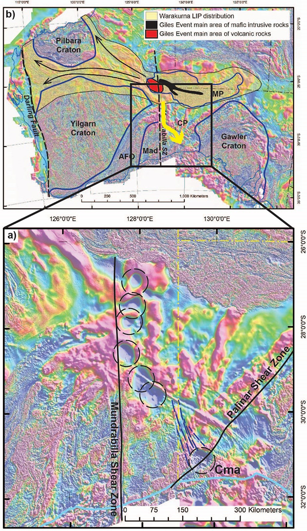
Figure 8 Reduction to pole aeromagnetic image showing the interpreted southward extension of the Warakurna LIP. a) Central southern Australia showing the remanently magnetised bodies (black dashed circles) forming a chain that connects the western Musgrave Province with the Coompana magnetic anomaly (labelled as Cma). Representative remanently magnetised dykes are shown as blue dashed lines. b) Reproduction of Figure 1 (modified from Smithies et al., 2015a), with the yellow arrow showing the extension of the Warakurna Supersuite to the south.
Structural controls on distribution of the Warakurna LIP in southern Australia
In the western Musgrave Province, mafic magmatism of the Warakurna Supersuite is interpreted to have been contemporaneous with deformation. The voluminous bimodal magmatism of the c. 1090–1040 Ma Giles Event was largely focussed within the Ngaanyatjarra Rift (Evins et al., 2010) that affected the Musgrave Province, and is characterised by a series of extensional and contractional deformation events (Aitken et al., 2013; Evins et al., 2010).
It has also been proposed that the Warakurna LIP magmatism was triggered when the regional Musgrave thermal anomaly was destabilised by movement along the Mundrabilla Shear Zone (Smithies et al., 2015a). Movement along the Mundrabilla Shear Zone also aligned the western Musgrave Province with the Capricorn Orogen, focussing magma flow further to the west.
The distribution of magmatism and structures recognised in southern Coompana Province suggests there was a structural control on Warakurna Supersuite magmatism in this area. In the CDP006 drillhole, two sets of veins were observed to cut both the basalts of the Warakurna Supersuite and the host migmatitic gneisses. The main vein population was northeast-trending, parallel to the Palinar Shear Zone, and the second set was north-trending. The veins record minor reactivation of the Palinar Shear Zone. Based on the orientations of the dilational veins and available kinematic indicators, this reactivation is interpreted to have been sinistral transtension along the northeast-trending shear. The field relations suggest the reactivation was either syn- or post Warakurna Supersuite magmatism at c. 1075 Ma.
Recent work by Yu et al. (2024) on epidote dating of Coompana Province samples provides absolute age constraints on this reactivation. No samples were taken from the CDP006 drillhole for this study. However, Lu–Hf dates of 1079 ± 30 Ma (composite of two samples) and 1072 ± 60 Ma (composite of three samples) were obtained for epidote in drillholes CDP001 and CDP005, respectively (Fig. 6). The epidote from CDP001 was found in quartz-epidote veins (Yu et al., 2024) that are steeply dipping and approximately northeast-trending. The epidote ages suggest the hydrothermal alteration, veining, and reactivation of the Palinar Shear Zone were contemporaneous with intrusion of the c. 1075 Ma Warakurna Supersuite (Jagodzinski et al., 2019; Wise et al., 2018a).
The orientations of the northwest-trending remanently magnetised dykes and chain of plutons suggest that the Warakurna Supersuite magmatism extended to the northwest of the Coompana magnetic anomaly (Fig. 8). This is orthogonal to the Palinar Shear Zone, and it is possible that the fracturing and dilation to form the northwest-trending dykes may represent a set of transtensional structures conjugate to the northeast-trending Palinar Shear Zone. The link of the c. 1075 Ma magmatism from the Coompana Province to the western Musgrave Province is completed by the north-trending chain of remanently magnetised bodies along the Mundrabilla Shear Zone (Fig. 8). It is proposed that as well as disrupting the Musgrave thermal anomaly and facilitating the flow of Warakurna Supersuite magmatism to the west (Smithies et al., 2015a), the Mundrabilla Shear Zone either focussed mafic magma flow to the south or triggered mantle melting along its length.
Implications
Given the Giles Complex is known to host magmatic Ni-Cu mineralisation (e.g. Glikson et al., 1996; Maier et al., 2014; Miller, 1969; Woodhouse and Gum, 2003), the presence of equivalent intrusive and extrusive units in the Coompana Province (i.e. Giants Head and Warbla suites) elevates the mineral potential of this region. Whilst minimal magmatic sulphide minerals were observed in GSSA drillholes, there is a significant volume of intrusive bodies interpreted because of this study. Implications of this interpretation are that there is untested sulphide potential within these bodies that may be highlighted with advanced exploration techniques e.g. electromagnetics.
As both volcanic and upper crustal intrusive components of the c. 1075 Ma mafic rocks are still found at palaeosurface (Dutch et al., 2017a; Dutch et al., 2017c), minimal erosion of this piece of crust occurred between c. 1075 Ma and when deposition of overlying basin units occurred. The lack of erosion implies that any potential mineral systems associated with the c. 1075 Ma magmatism would still be preserved. This is a favourable factor when assessing areas for mineral exploration.
The recognition of c. 1075 Ma magmatism in the Coompana Province, temporally and structurally linked with the Warakurna LIP significantly increases the magmatic footprint of the LIP. Whilst this magmatism in the Coompana Province is largely structurally controlled, it is likely that the increased magmatic footprint is also associated with a broader thermal/hydrothermal and tectonic footprint. Shear zones within the northern and western Gawler Craton may have experienced reactivation and fluid-flow as a response to this event, similar to what is described on the Palinar Shear Zone (Yu et al., 2024). Reid and Forster (2021) show that the northern Gawler Craton records tectonothermal activity dominantly in the window c. 1530–1300 Ma, but also indicates a minimum age on thermal disturbance down to c. 1090 Ma on drillhole OBD 09. This suggests there may be distal effects of the Giles Event.
Acknowledgements
The GSSA acknowledges the Mirning People, and the members of the Far West Coast Aboriginal Corporation, who are the traditional owners of this land. The GSSA would also like to acknowledge the hard and constructive work undertaken by staff of the Department of Environment and Water and the Alinytjara Wilurara Natural Resources Management (AWNRM) including the members of the Nullarbor Parks Advisory Committee, who provided the necessary approvals to undertake the geophysical data collection and drilling within the Nullarbor Parks. Sam Connell of GSSA provided a thorough and thoughtful review of the manuscript.
References
Aitken ARA, Smithies RH, Dentith MC, Joly A, Evans S and Howard HM 2013. Magmatism-dominated intracontinental rifting in the Mesoproterozoic: The Ngaanyatjarra Rift, central Australia. Gondwana Research 24(3–4):886–901.
Alghamdi AH, Aitken ARA and Dentith MC 2018. The deep crustal structure of theWarakurna LIP, and insights on Proterozoic LIP processes and mineralisation. Gondwana Research 56:1–11.
Craton Resources NL 1999. EL 2484, EL 2513 AND EL 2514, Mount Howe, Mount Mead and Tieyon areas (East Musgrave Project). Annual and final report for the period 15/1/98 to 9/9/99. Open file Envelope 09513. Department of Primary Industries and Resources, South Australia. https://pid.sarig.sa.gov.au/document/mesac18790
Dutch RA 2018. Coompana Province geochemistry and petrogenesis. In RA Dutch, TW Wise, MJ Pawley and A Petts eds. Coompana Drilling and Geochemistry Workshop, 2018. Extended abstracts. Report Book 2018/00019, p. 76–101. Department of the Premier and Cabinet, South Australia. https://pid.sarig.sa.gov.au/document/2018d051182
Dutch RA, Jagodzinski EA, Wise TW, Pawley MJ, Tylkowski L, Lockheed A, McAlpine SRB and Heath P 2017a. PACE Copper Coompana Drilling Project: Drillhole CDP002 preliminary field-data report. Report Book 2017/00038. Department of the Premier and Cabinet, South Australia. https://pid.sarig.sa.gov.au/document/d20011707
Dutch RA, Pawley MJ, Wise TW, Tylkowski L, Lockheed A, Jagodzinski EA, McAlpine SRB and Heath P 2017b. PACE Copper Coompana Drilling Project: Drillhole CDP006 preliminary field-data report. Report Book 2017/00043. Department of the Premier and Cabinet, South Australia. https://pid.sarig.sa.gov.au/document/d20011713
Dutch RA, Reid A, Smithies RH, Payne J, Jagodzinski EA, Kirkland CL, Pawley MJ, Spaggiari CV and Preiss WV 2016. Is Southern Australia bent?; recognition of a contiguous Palaeoproterozoic magmatic arc along the western margin of the Mawson Continent. In Proceedings 2016 Australian Earth Science Convention: Uncover Earth’s Past to Discover Our Future, South Australia. p. 119.
Dutch RA, Wise TW, Jagodzinski EA, Pawley MJ, Tylkowski L, Lockheed A, McAlpine SRB and Heath P 2017c. PACE Copper Coompana Drilling Project: Drillhole CDP008 preliminary field-data report. Report Book 2017/00045. Department of the Premier and Cabinet, South Australia. https://pid.sarig.sa.gov.au/document/d20011716
Dutch RA, Wise TW, Pawley MJ and Petts A 2018. Coompana Drilling and Geochemistry Workshop, 2018. Extended abstracts. Report Book 2018/00019. Department of the Premier and Cabinet, South Australia. https://pid.sarig.sa.gov.au/document/2018d051182
Evins PM, Smithies RH, Howard HM, Kirkland CL, Wingate MTD and Bodorkos S 2010. Devil in the detail; The 1150–1000 Ma magmatic and structural evolution of the Ngaanyatjarra Rift, west Musgrave Province, Central Australia. Precambrian Research 183(3):572–588.
Glikson AY, Stewart AJ, Ballhaus CG, Clarke GL, Feeken EHJ, Leven JH, Sheraton JW and Sun S-S 1996. Geology of the western Musgrave Block, central Australia, with particular reference to the mafic-ultramafic Giles Complex. Bulletin 239. Australian Geological Survey Organisation, Canberra, Australia.
Godel B, Seat Z, Maier WD and S-J B 2011. The Nebo-Babel Ni-Cu-PGE Sulfide Deposit (West Musgrave Block, Australia): Pt. 2. Constraints on Parental Magma and Processes, with Implications for Mineral Exploration. Economic Geology 106:557–584.
Hartnady MIH, Kirkland CL, Dutch RA, Bodorkos S and Jagodzinski EA 2018. Zircon Hf isotopic signatures of the Coompana Province in South Australia. In RA Dutch, TW Wise, MJ Pawley and A Petts eds. Coompana Drilling and Geochemistry Workshop, 2018. Extended abstracts. Report Book 2018/00019, p. 132–144. Department of the Premier and Cabinet, South Australia. https://pid.sarig.sa.gov.au/document/2018d051182
Heath P, Reed G and Katona LF 2015. Coompana airborne survey. MESA Journal 79(4):18–21. Department of State Development, South Australia. https://pid.sarig.sa.gov.au/document/mesac26699
Howard HM, Smithies RH, Evins PM, Kirkland CL, Werner M, Wingate MTD and Pirajno F 2011. Explanatory notes for the west Musgrave Province. Record. Geological Survey of Western Australia.
Jagodzinski EA, Bodorkos S, Crowley JL, Pawley MJ and Wise TW 2019. PACE Copper Coompana Drilling Project: U-Pb dating of basement and cover rocks. Report Book 2018/00028. Department for Energy and Mining, South Australia. https://pid.sarig.sa.gov.au/document/2019d040097
Kirkland CL, Smithies RH, Spaggiari CV, Wingate MTD, Quentin de Gromard R, Clark C, Gardiner NJ and Belousova EA 2017. Proterozoic crustal evolution of the Eucla basement, Australia: Implications for destruction of oceanic crust during emergence of Nuna. Lithos 278–281:427–444.
LeMaitre RW 1989. A classification of Igneous Rocks. Oxford, Blackwell.
Maier WD, Howard HM, Smithies RH, Yang S, Barnes S-J, O’Brian H, Huhma H and Gardoll S 2014. Mafic-ultramafic intrusions of the Giles Event, Western Australia: petrogenesis and prospectivity for magmatic ore deposits. Report 134. Geological Survey of Western Australia.
Mason DR 2018. Petrographic Descriptions for Sixty-seven Rock Samples, Coompana Drilling Project, South Australia. Mason Geoscience Pty Ltd, p. 144.
Miller PG 1969. Final report on nickel investigations, North West Province 1953-1967. Report Book 68/00095. South Australian Department of Mines. https://pid.sarig.sa.gov.au/document/rb6800095
Pawley MJ, Wise TW, Dutch RA and Jagodzinski EA 2020. New Proterozoic stratigraphic units of the Coompana Province of South Australia. MESA Journal 93(2):4–23. Department for Energy and Mining, South Australia. https://pid.sarig.sa.gov.au/document/mesac29298
Pawley MJ, Wise TW, Dutch RA, Spaggiari CV, Thiel S, Holzschuh J and Doublier MP 2018a. What the 13GA-EG1 Eucla-Gawler Seismic Survey tells us about the Coompana Province. In RA Dutch, TW Wise, MJ Pawley and A Petts eds. Coompana Drilling and Geochemistry Workshop, 2018. Extended abstracts. Report Book 2018/00019, p. 109–119. Department of the Premier and Cabinet, South Australia. https://pid.sarig.sa.gov.au/document/2018d051182
Pawley MJ, Wise TW, Jagodzinski EA, Dutch RA, Tylkowski L, Lockheed A and McAlpine SRB 2018b. Coompana Drilling Project: Basement lithologies and structure. In RA Dutch, TW Wise, MJ Pawley and A Petts eds. Coompana Drilling and Geochemistry Workshop, 2018. Extended abstracts. Report Book 2018/00019, p. 52–65. Department of the Premier and Cabinet, South Australia. https://pid.sarig.sa.gov.au/document/2018d051182
Reid AJ and Forster M 2021. Mesoproterozoic thermal evolution of the northern Gawler Craton from 40Ar/39Ar geochronology. Precambrian Research 358(106180).
Seat Z, Beresford SW, Grguric BA, Waugh RS, Hronsky JMA, Gee MAM, Groves DI and Mathison CI 2007. Architecture and emplacement of the Nebo-Babel gobbronorite-hosted magmatic Ni–Cu–PGE sulphide deposit, West Musgrave, West Australia. Mineralium Deposita 42:551–582.
Smithies RH, Howard HM, Evins PM, Kirkland CL, Kelsey DE, Hand M, Wingate MTD, Collins AS and Belousova EA 2011. High-temperature granite magmatism, crust–mantle interaction and the Mesoproterozoic intracontinental evolution of the Musgrave Province, Central Australia. Journal of Petrology 52(5):931–958.
Smithies RH, Kirkland CL, Korhonen FJ, Aitken ARA, Howard HM, Maier WD, Wingate MTD, Quentin de Gromard R and Gessner K 2015a. The Mesoproterozoic thermal evolution of the Musgrave Province in central Australia — Plume vs. the geological record. Gondwana Research 27(4):1419–1429.
Smithies RH, Spaggiari CV, Kirkland CL, Wingate MTD and England RN 2015b. Forrest Zone: geochemistry and petrogenesis. In CV Spaggiari and RH Smithies eds. Eucla basement stratigraphic drilling results release workshop: extended abstracts. Record 2015/10, p. 41–51. Geological Survey of Western Australia.
Sun S-S, Sheraton JW, Glikson AY and Stewart AJ 1996. A major magmatic event during 1050-1080 in central Australia and an emplacement age for the Giles Complex. AGSO Research Newsletter 24:13-15.
Swain GM, Barovich KM, Hand M, Ferris GM and Schwarz MP 2008. Petrogenesis of the St Peter Suite, southern Australia: Arc magmatism and Proterozoic crustal growth of the South Australian Craton. Precambrian Research 166(1–4):283–296.
Wade BP, Payne JL, Hand M and Barovich KM 2007. Petrogenesis of ca 1.50 Ga granitic gneiss of the Coompana Block: filling the ‘magmatic gap’ of Mesoproterozoic Australia. Australian Journal of Earth Sciences 54(8):1089–1102.
Wingate MTD, Kirkland CL, Spaggiari CV and Smithies RH 2015. U-Pb geochronology of the Forrest Zone of the Coompana Province. In CV Spaggiari and RH Smithies eds. Eucla basement stratigraphic drilling results release workshop: extended abstracts. Record 2015/10, p. 37–40. Geological Survey of Western Australia.
Wingate MTD, Pirajno F and Morris PA 2004. Warakurna large igneous province: A new Mesoproterozoic large igneous province in west-central Australia. Geology 32(2):105–108.
Wise TW, Dutch RA, Pawley MJ, Foss C and Thiel S 2018a. Building the Coompana Province. MESA Journal 88(3):25–37. Department of State Development, South Australia. https://pid.sarig.sa.gov.au/document/mesac28149
Wise TW, Pawley MJ and Dutch RA 2015. Preliminary interpretations from the 2015 Coompana aeromagnetic survey. MESA Journal 79:22–30. Department of State Development, South Australia. https://pid.sarig.sa.gov.au/document/mesac26700
Wise TW, Pawley MJ, Dutch RA 2018b. Interpreted geology map of the eastern Coompana Province. In RA Dutch, TW Wise, MJ Pawley and A Petts eds. Coompana Drilling and Geochemistry Workshop, 2018. Extended abstracts. Report Book 2018/00019, p. 102–108. Department of the Premier and Cabinet, South Australia. https://pid.sarig.sa.gov.au/document/2018d051182
Woodhouse AJ and Gum JC 2003. Musgrave Province - geological summary and exploration history. Report Book 2003/00021. Department of Primary Industries and Resources, South Australia. https://pid.sarig.sa.gov.au/document/2019d079150
Yu J, Glorie S, Hand M, Simpson A, Gilbert S, Szilas K, Roberts NMW, Pawley MJ and Cheng Y 2024. Laser ablation (in situ) Lu-Hf geochronology of epidote group minerals. Contributions to Mineralogy and Petrology 179(62).