
The generation of new mineral exploration targets is data-driven and the Department for Energy and Mining has recognised that our data has to be developed to support modern exploration.
The future requires near real-time, seamless, high quality digital geological data which is compatible with machine learning and artificial intelligence programs.
The South Australian Discovery Mapping (SADM) project aims to do just that by modernising the capture, management, delivery, and scope of South Australia's pre-competitive geological map datasets.
This project will provide extensive support to industry and assist with de-risking areas of the state.
Project summary
SADM has four integrated programs:
- Develop a modern data management system which integrates with existing databases now, and into the future.
- Design and build a data capture system to manage the new geological mapping data with in-built quality control.
- Design and build a data capture system to manage the new Digital Explanatory Notes which describe the state’s geology within four categories:
- Stratigraphic units
- Geological provinces
- Major geological events
- Time slices - Design and build a data delivery system for mapping data and explanatory notes using SARIG and web services for data access.
The system is being developed to deliver modern geological data South Australia-wide, however the initial focus will be on the Gawler Craton Airborne Survey (GCAS) region with the aspiration for future expansion to the rest of the state. Existing data will be translated and integrated into the system to provide a single point of truth for South Australian geological data.
This project will exponentially improve upon the geological data currently available for mineral exploration and the general public. The diagram below demonstrates the level of mapping data detail to be delivered by the project through the geological interpretation of the GCAS data (right) in comparison with the existing solid geology (left).
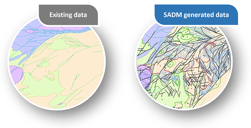
The SADM project will deliver significantly improved and seamless geological map and associated data in a format that better meets the business needs of mineral explorers and data scientists. This will facilitate mineral exploration targeting using machine-learning, thus supporting the development of the mineral resources sector in South Australia.
Project diary
August 2025
The wait is over - SADM has launched!
After five years of collaboration, hard work, and fine-tuning, the South Australian Discovery Mapping (SADM) project is live, and we are thrilled to announce the official launch. This marks a major milestone in how we access, interpret, and utilise geological data.
Brought to life by the Geological Survey of South Australia (GSSA), with the support of Esri Australia’s ArcGIS Enterprise, SADM is much more than just a map - it’s a powerful new platform that transforms South Australia's geological data into an accessible, dynamic interface.
What’s new in August
The flagship 1st Edition SA Geology is now available, comprised of digital spatial data featuring 45 richly attributed geology layers across 14 timeslices, as well as the Digital Explanatory Notes (DEN) that provide linked, searchable geological reports that connect with spatial data attribution in SARIG.
These are avaliable via SARIG Map, SARIG Catalogue, and downloadable datasets, with full GeoSciML web services for AI/ML integration.
The Future of Geological Exploration
SADM modernises the delivery of geological data by bringing together spatial and textual data in one searchable, standardised platform. The platform is designed to support real-time updates, future-proofing access, and integration with AI/ML workflows. Whether you're conducting mineral exploration, academic research, or strategic planning, SADM provides a more effective way to interact with pre-competitive data.
Focus on the Western Gawler Craton
For our launch, we’ve focused on the Western Gawler Craton, with a rich suite of data for complex regions like the Mount Woods Domain. SADM unlocks previously hidden geological complexities, providing:
- Insights into the tectonic history of regions across multiple time slices.
- Structural mapping using Bouguer gravity and RTP imagery.
- Enhanced mineral potential analysis.
This isn’t just new data - it’s a new way of reading South Australia’s geological story.
The teams behind the build
This project has been a collaborative effort over five years, with contributions from a diverse team of geoscientists, GIS experts, software developers, and project managers.
his month, the Seamless Geology spatial data has had the final integration with web-based services, ensuring that the data can be accessed anytime, anywhere. This achievement is a game-changer for the accessibility of South Australia’s geological datasets.
We’d like to extend a special thank you to all those who played a pivotal role in bringing this vision to life. Their dedication has resulted in a platform built for future growth, AI compatibility, and real-time data access.
Read more about the teams below in the May diary update.
Explore SADM Now
Ready to dive in? You can explore the new platform now:
June 2025
The GSSA has issued a new report book on SADM datasets:
Geochronology on the buried northern Gawler Craton
Part 1 – Multi-mineral laser-ablation U–Pb–Lu–Hf dating
This report is the first in a series presenting findings from geochronological and petrological investigations of various lithologies sampled across the northern Gawler Craton. The sampling forms part of the SADM project, which aims to provide extensive and improved geological mapping data and datasets to both the mineral exploration industry and the public via a modern data delivery system.
This study was undertaken to fill significant gaps in existing geochronological data, which are sparse across the region. This lack of data has limited the correlation of known lithological units over large areas and the identification of major structural boundaries.
Ten samples were collected from several key locations, including the Mount Woods, Nawa, abd Coober Pedy Ridge domains. A variety of rock types were analysed as part of this study, from meta-mafic rocks, granitoids, and calc-silicate lithologies to low metamorphic grade metasediments.
U–Pb geochronology using laser-ablation inductively-coupled-plasma mass spectrometry (LA-ICP-MS) was applied to zircon and apatite, with additional U–Pb dating on monazite and rutile, and Lu–Hf isotopic analysis on apatite, calcite, and garnet, depending on sample mineralogy and knowledge gaps.
Download the report book and data
May 2025
The South Australian Discovery Mapping project has reached the testing stage, and there is a lot of excitement growing about the final digital geology product, and its benefits for South Australia and our stakeholders, such as:
- Increased accessibility and usability of pre-competitive data delivered to industry
- Future proofing: data is digital, searchable, and readily updatable
- Data which fosters a workflow linking geological processes
- Promotion of data driven exploration and creative thinking
As each team tirelessly undertakes rounds of user testing and build modifications, we wanted to share some photos as well as a preview of the new Digital Explanatory Notes interface.

Early working interface for SADM’s Digital Explanatory Notes (click for a larger version).
To ensure the success of the SADM project, the GSSA implemented the use of ESRI’s ArcGIS Enterprise as the foundational infrastructure for the Project. This base platform supported the project team’s focus on the initial system design and build along with the data compilation phases.
ArcGIS Enterprise has put collaboration and flexibility at the centre of the state’s geological compilation, pairing mapping and analytical capabilities with a dedicated Web GIS infrastructure to organise and share service across any device, anywhere, and any time.

Previously the SADM project had focused on the internal system design build and data compilation phases, but the SARIG Delivery team has also been exploring how the new Seamless Geology spatial data will interact with our downloadable and web service products, as well as our SARIG suite of products.

Members of the SARIG Delivery Team
(L to R) Jonathon Irvine, George Gouthas, and Jesse Francis (Absent: Ursula Michael)
Delivery will extend ArcGIS Enterprise for external use enabling the hosting of feature datasets produced by the SADM project team and after passing thorough all validation checks required and approved to be released as production-ready data. The approved datasets can then be published as data services shared publicly, with query only capabilities. The wider GSSA team will be looking at hosting other open-source services that will allow publishing web services that implement and deliver the GeoSciML interface.
The data in the SADM system has been ground-truthed in strategic locations, constrained by existing drilling, and refined with new analytical work - which you’ll see more of soon!

Members of the SADM Map Compilation Team plus GSSA geologists and collaborators.
(L to R) Jack Percival (SADM), Tom Wise (GSSA), Morgan Blades (Adelaide University), Mitchell Bockmann (GSSA), Rashed Abdullah (SADM), Stephen Hore (GSSA), and Claire Wade (GSSA).

Digital Explanatory Notes team
(L to R) Samuel Connell, Charlotte Mitchell, Farida Khanam, Mario Werner, Amie Amir, and Seth Tiddy.
Over the next few weeks, the team will be focusing on finalising the initial release of our SADM geological mapping products and datasets.
To get further updates on the SADM project, sign up to the GSSA’s newsletter.
March 2025
The SADM spatial data compilation has been progressing well, generating attributed, detailed linework across the Mt Woods Complex, as well as the northeastern Nawa and Nuyts domains. This work has led to an increased geological understanding of these regions.
The compilation team has been using their knowledge of the northern Gawler Craton to contribute to the National Drilling Initiative by helping with drill hole target selection, logging of the holes, and interpretation of the results. They have also been helping with the western Gawler Craton to review and provide content for the stratigraphic unit reports prepared by the DEN team.
The geochronology team, in collaboration with the compilation team, selected and is analysing samples for age dating. These samples will be used to help the compilers provide the best possible interpretation of rocks that can be poorly exposed, or only intersected in drill core. Considerable work has been done on the LA-ICPMS and SHRIMP dating of samples, and these results are being interpreted and incorporated into reports. Further samples will be dated in the near future.
The SADM DEN team is finalising reports for Events, Timeslices, Provinces and Stratigraphy as the DEN delivery progresses. An example of the type of research and compilation required for each report is highlighted in Sam Connell’s 2024 Discovery Day talk, Linking South Australia’s geology - fostering new workflows through digital report data (Officer Basin Case Study)
- View the PDF of the slides (PDF, 26.2 MB)
- View the video of the presentation
The new Digital Explanatory Notes (DEN) application is on schedule for release. The build is complete, and the project has moved into the testing phase. Geological reports for initial delivery are currently being finalised. These initial reports will relate to the mapped geology of the western GCAS area of the Gawler Craton. Information for the remainder of the GCAS and other areas of the state are in the planning phase and will become available as they are written. This will be ongoing after the initial public release, as the new DEN application joins the SARIG (South Australian Resources Information Gateway) platform.

February 2025
We recently released a new video explaining how the SADM compilation team is interpreting the geophysical data. Frank Rarity gives a fantastic overview and update of the SADM project.
At NTGS’s Gabfest in Darwin, our team presented on the SADM project. This presentation introduced the whys, what’s, and how’s of the project to an audience of geoscientists and data management staff from different state and federal organisations, and universities.
November 2024
Over various conferences in November, our team presented updates on the latest with the SADM project.
- Rashed Abdullah presented Orientation controls activation: the kinematic evolution of the Mount Woods Domain, Gawler Craton (PDF, 24.7 MB) at the Specialist Group in Tectonics and Structural Geology meeting in Armidale, NSW.
- At our 2024 Discovery Day, Rashed also held a talk Unravelling complex basement geology via SADM: an example from the Mount Woods Domain, Gawler Craton.
- Frank Rarity also presented at our 2024 Discovery Day, with Aeromagnetic character and kinematics of the Yarlbrinda Shear Zone.
October 2024
The SADM team have continued to populate the new digital explanatory notes which will form the basis of an interactive interface within SARIG. This new text will be based on the most current data and research. The four types of digital explanatory notes will include:
- Time slices – Geological information relating to major time periods defined by similar tectonic processes in South Australia. Special time slices for the Hiltaba Suite and Gawler Range Volcanics.
- Events – Documents detailing the major tectonic and/or metamorphic events that have occurred in South Australia through time.
- Provinces – Documents focused on specific geological provinces and basins.
- Stratigraphy – Descriptive documents for individual geological units.
Compilation work for both digital explanatory notes and mapping data continues within the designated GCAS area allowing synergy between the two teams, with compilation on the remainder of the state's geology to follow the initial delivery.
Major milestones for the explanatory notes team have included completing:
- Drafts for the major Gawler Craton and Officer Basin province reports.
- First-pass population of the defined 14 time slice reports which has highlighted areas needing geological clarity.
- Over 150 drafts for individual stratigraphic unit reports.
- Multiple reports completed for major geological events in the Gawler Craton region such as the Kimban Orogeny.
Work has also been completed for the SARIG-based interface for explanatory notes including visuals, layout, design interface and user requirements to search the newly compiled documents.
In August, members of the compilation team took part in a field trip to the northern Gawler Craton. The SADM project is largely a desktop study, but this trip gave the compilers the opportunity to ground-truth their work and collect samples to constrain their interpretations.


April 2024
The SADM compilation team has been inspecting and sampling drill core from the poorly exposed and understood regions of the northern and southwest Gawler Craton. The collected samples will be dated, providing important constraints on the age of the rocks and timing of the deformation they experienced. This information will be used to improve the attribution of the spatial features.
January 2024
SADM’s key priorities in 2024 shift from development to implementation. Data compilation continues to pull together mapping and attributes for the Gawler Phase 2 (GP2) and western GCAS region, which will be followed by the import and stitching of best data from the rest of the State.
View the SADM presentation from Discovery Day 2023
August 2023
Significant work has been done on SADM with exciting milestones achieved.
- The enterprise spatial database has been completed.
- Map compilation has begun, using consistent interpretation methodologies to ensure seamless results for users.
- South Australian Digital Explanatory Notes (DEN) are being developed to ensure standard definitions across stratigraphic units, geological provinces, events and time slices.
The team expect to highlight some of the SADM workflows at Discovery Day 2023.
April 2023
The Gawler Craton Airborne Survey was completed in July 2019 and provided detailed airborne magnetic, radiometric, and digital elevation coverage across approximately 30% of South Australia and 55% of the Gawler Craton.
A new report book – A user’s guide to the Gawler Craton Airborne Survey magnetic field datasets: visualisation and interpretation – provides a useful guide on how to make the best use of the GCAS magnetic field datasets, which are a valuable resource for those wanting to understand the geology and mineral potential of the Gawler Craton.
These datasets are critical for the new interpretation of the Gawler Craton’s basement geology, which is being undertaken as part of the SA Discovery Mapping project.
Download the report book and data
December 2022
At Discovery Day 2022 Dr Megan Williams updated the audience on the stratigraphic definition work being undertaken as part of SA Discovery Mapping and explores how the fundamental work of stratigraphic definition can provide new avenues for investigation of geology and mineralisation potential.
View the SADM presentation from Discovery Day 2022
November 2022
A new article in the MESA Journal highlights the work done, and the data available, on aeromagnetic images as part of the SA Discovery Mapping project. The article Aeromagnetic images of the Gawler Craton: enhancements serving geological interpretation using the HSV colour model looks at a procedure for image enhancement applied to the aeromagnetic component of the Gawler Craton Airborne Survey (GCAS). These enhanced images will support the new digital, machine readable and optimised mapping being developed through SA Discovery Mapping.
November 2022
System design and data compilation for a new Digital Explanatory Notes feature in SARIG are underway. These notes will contain concise and up-to-date information about the stratigraphy, provinces and geological history of South Australia to accompany new map data.
September 2022
The system build for SADM has begun and will leverage the ArcGIS Enterprise environment capability to deliver robust data validation and automation workflows management system. The system build is the backbone of SADM and configuring it correctly will ensure the data compilation phase of the project runs smoothly.
Project resources
Digital to the Core 2021–2025. The Geological Survey of South Australia's 5 year digital strategy lays out the extensive digital focus and new initiatives being developed to support exploration.