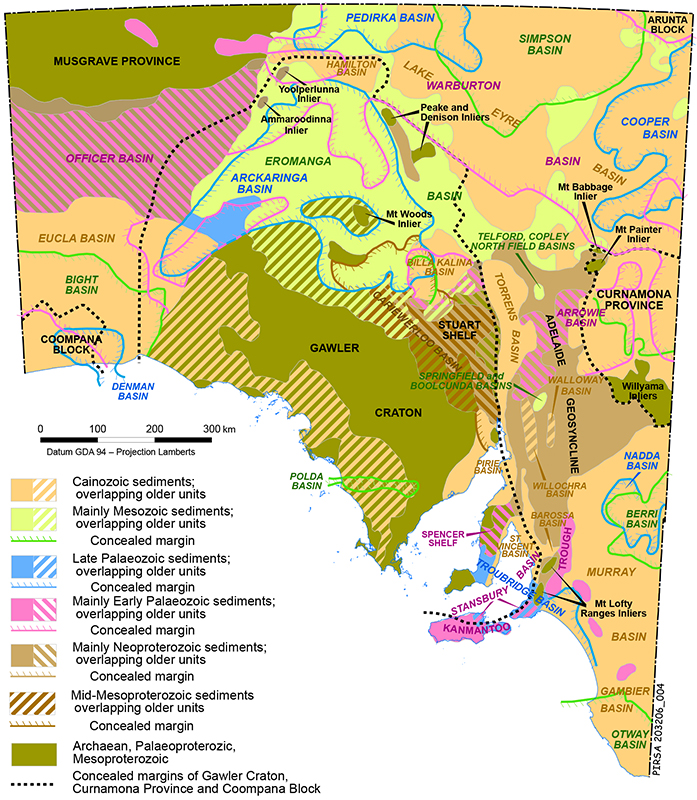
Geologists classify the rocks of a region by correlating, or grouping them together, on the basis of similar age, interpreted origin, and lithology. Stratigraphic names (e.g. Sleaford Complex) are often applied to these groupings as an aid to communication. Our present understanding of South Australia’s geological history and mineral deposits is the result of the integration of over 150 years of careful observation of rocks and their relationships. As the inventory of geological understanding has grown, it has become evident that our preserved geological history occupies discrete spans of time, separated by periods of no record. At a broad level, the rocks formed during these spans of time are grouped into geological provinces, including sedimentary basins, with different names given to distinct groups of rocks formed during the same time period in different parts of the State.
Below are links to detailed information on the major geological provinces in South Australia.
- Arckaringa Basin
- Arrowie Basin and Adelaide Rift Complex
- Bight Basin (includes Ceduna Sub-basin)
- Bight Basin (includes Duntroon Sub-basin)
- Cariewerloo Basin
- Cooper Basin
- Curnamona Province
- Eromanga Basin
- Eromanga Basin and Mesozoic Era
- Gawler Craton
- Lake Eyre Basin
- Officer Basin
- Otway Basin
- Musgrave Province
- Pedirka Basin
- Polda Basin
- Renmark Trough
- Regolith in South Australia
- Simpson Basin
- Stansbury Basin
- Warburton Basin


