
In 2021 the Geological Survey of South Australia released Digital to the Core 2021–2025, outlining how we would be developing our current digital ecosystem to harness the value of geoscience information for data-driven decision making, knowledge discovery and emerging exploration technologies.
Strategic vision
The Geological Survey of South Australia will deliver fundamental geoscience data and service platforms to enable a modern data-driven exploration revolution in South Australia.
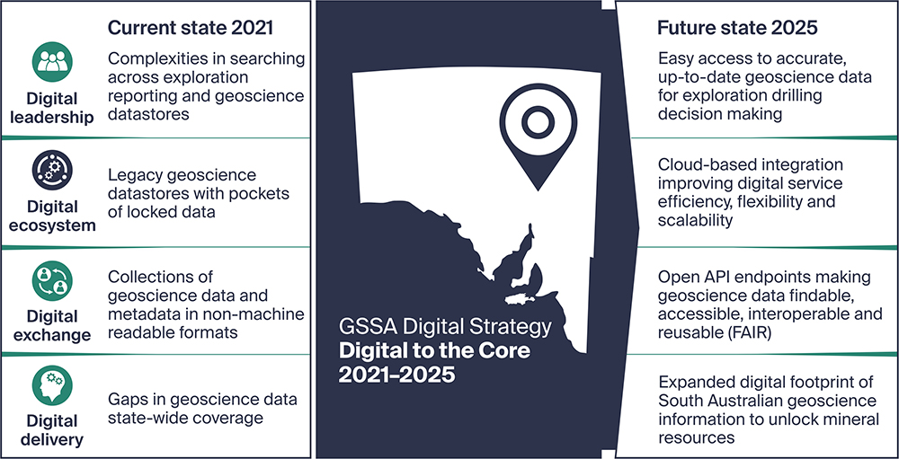
Text description of current and future digital state (TXT, 1.0 KB)
Download Digital to the Core 2021–2025 (PDF, 3.2 MB)
Strategic core areas and highlighted projects

ACTION – Establish a high-level digital governance framework to enable strategic decisions and build our strength, skills and learning culture in emerging digital technologies.
Project: Expanding digital geoscience communications (Ongoing)
Measures of success
- Expansion of GSSA digital stakeholder communications, sharing project innovations by the creation of a webinar series program and a new e-newsletter format.
Achievements to date

ACTION – Develop a trusted, secure, high-performing digital ecosystem enabling us to produce world-leading geoscience connectivity to our stakeholders.
Project: SA Geodata modernisation (2021–2024)
Replacing South Australia’s geoscientific and hydrogeological database in conjunction with Department for Environment and Water. This will result in enhanced functionality and performance for stakeholders looking to access South Australia’s data.
Measures of success
- Improved access, data reliability, data accuracy, interoperability and metadata quality of digital assets.
- Reducing the need for data cleansing and creating trust and confidence in data utilisation.
- Establishing cloud-hosting to enable efficient access to high volume geoscience datasets.
- Reduced legacy database dependency and siloed system development.
Achievements to date
- Requirements gathering and technical design phase.
Project: Publications and reports digital restart (2021–2023)
Making it easier to search for and find mineral and energy reports and publications from South Australia through SARIG.
The project will ensure search terms are more logical, consistent, provide API access to the catalogue and make open file industry drilling programs reports and data easier to find.
Measures of success
- Adopting new technology to improve service delivery of open file company exploration reports and data.
- Enabling improved capture, content, and delivery of an international metadata schema across all geoscience digital assets.
- Establishing cloud-hosting to enable efficient access to high volume geoscience datasets.
- Published South Australian vocabulary management service.
- Reduced legacy database dependency and siloed system development.
Achievements to date
- Cloud-based architecture design completed.
- New vocabulary terms developed.

ACTION – Seamless data exchange to stimulate national and international partnerships and collaborations to further digitally enable science innovation.
Project: SARIG development (Ongoing)
The development of SARIG is an ongoing process and we are constantly working to ensure its accessibility, reliability and accuracy are as good as they can be. Understanding our customers primary frustrations is helping develop a plan for SARIG’s future.
Measures of success
- Sustainable platforms, mobile apps and digital services developed for geoscience collaboration.
Achievements to date
- Gain customer insights and identify areas of user experience that require improvement.
- Update of map catalogue themes and map layer list functionality.
Project: GP2: next generation mineral systems mapping (2021–2025)
ExploreSA showed that GSSA data has enormous power and potential but work was needed to make it fully accessible, complete and able to be integrated with current and future machine learning and artificial intelligence applications.
Measures of success
- Expand our geoscientific digital footprint and knowledge of mineral systems in South Australia.
Achievements to date
- Acquisition of new geophysical, geochemistry, geochronology and petrophysics and legacy data.
Read more about GP2: next generation mineral systems mapping
Project: Delamerian National Drilling Initiative (NDI) – completed
The Geological Survey of South Australia has partnered with the MinEx CRC to undertake a National Drilling Initiative project on the under-explored Delamerian Orogen.
Measures of success
- Expand our geoscientific digital footprint and knowledge of mineral systems in South Australia.
- Continued collaboration and building new partnerships and knowledge exchange opportunities.
- Increased discovery of our digital assets though modern visualisation tools.
Achievements to date
- 24 new drillholes within the Delamerian basement and overlaying Murray Basin cover.
- SA Drilling Atlas
Read more about the Delamerian National Drilling Initiative (NDI)
Project: Sedimentary Copper Mineral Systems of the Stuart Shelf
The GSSA has partnered with CSIRO on this joint project to develop a robust model and understanding of the basin architecture of the Stuart Shelf to guide exploration for sedimentary copper in this area.
Measures of success
- Expand our geoscientific digital footprint and knowledge of mineral systems in South Australia.
- Continued collaboration and building new partnerships and knowledge exchange opportunities.
Achievements to date
- 10,570 metres of drill core logged from the Stuart Shelf.
- Stuart Shelf sedimentary copper 3D model
- South Australian Neoproterozoic Sediment-hosted Copper Occurrence map
Read more about the Sedimentary Copper Mineral Systems of the Stuart Shelf project
Project: AusArray SA broadbrand seismic array – completed
The GSSA partnered with Geoscience Australia and the Australian National University to undertake the AusArray SA broadband seismic array to collect passive seismic data.
Measures of success
- Expand our geoscientific digital footprint and knowledge of mineral systems in South Australia.
- Continued collaboration and building new partnerships and knowledge exchange opportunities.
Achievements to date
- Raw seismic data collected.

ACTION – Innovate with past and future data collections, providing the right tools for future exploration and research technologies.
Project: South Australian Discovery Mapping (2021–2024)
Modernising the capture, management, delivery and scope of South Australia’s geological map datasets to provide a wider breadth of high-quality data in support of mineral exploration. This project will work closely with the SA Geodata modernisation to ensure streamlined access to all data.
Measures of success
- Delivery of a new suite of seamless statewide high-resolution spatial geoscience datasets.
- Delivery of an enriched, interoperable South Australian stratigraphy database.
- Enriched delivery and industry adoption of machine-readable web services.
Achievements to date
- Sandbox version database infrastructure developed.
Read more about SA Discovery Mapping
Project: Legacy data capture
Working across a variety of projects including Gawler Phase 2 and South Australian Discovery Mapping, the GSSA has a focus on releasing legacy data from its current inaccessible formats and bringing to industry in a usable way.
Measures of success
- Improve legacy data capture workflows to increase the volume of available drilling and sampling data across South Australia.
- Expanding the digital footprint of geoscience data in South Australia.
Achievements to date
Data has been transferred from non-digital format for:
- Lithology information from 11,000 drillholes.
- 168,000 geochmical analyses.
- 1,000 drillholes with petrophysics logs.