Steve Barnett1 and Robert Bourman2, 3, 4
1 Department for Environment and Water
2 School of Earth, Atmospheric and Life Sciences, University of Wollongong
3 Department of Geography, Environment and Population, The University of Adelaide
4 College of Science and Engineering, Flinders University
Download this article as a PDF (2.3 MB); cite as MESA Journal 96, pages 22–26
Published March 2022
Introduction
The McLaren Vale area is one of the major wine producing areas in South Australia and its development has been highly dependent on the groundwater resources of the Willunga Embayment. The Cenozoic sediments within the Willunga Embayment have been well described by Cooper (1977, 1979) and Fairburn (1998).
As part of a project to investigate salinity increases in some aquifers, a further 300 drillers’ logs and 50 mineral well logs were added to SA Geodata – the state’s primary geoscientific data repository. This allowed structure contours of the various sedimentary units to be constructed with greater resolution than before.
Analysis of this more detailed information has revealed new insights into the structural geology of the embayments and prompted a revision of the hydrostratigraphy and recommendations for changes in the way the valuable groundwater resources of the region are managed.
Pirramimma Sand
The Port Willunga Formation aquifer was previously assumed to comprise not only the Cenozoic marine limestone, but also the ‘Pirramimma Sand Member’ which was considered to be a marginal sand facies of the Port Willunga Formation (Cooper 1977). Consequently, construction of water level contours and interpretation of water level and salinity trends assumed that these two units had such a very high hydraulic connection that they could be considered to be one continuous aquifer.
However, after an extensive field mapping exercise, Fairburn (1998) redefined the ‘Pirramimma Sand Member’ as the ‘Pirramimma Sandstone’ of interpreted Early Pleistocene age, which he described as a fluvial sandstone that was deposited in ‘a ravine-like channel deeply eroded into older Pleistocene and Tertiary strata’. It comprises a mainly buff coloured, fine-grained, well-sorted and poorly consolidated sandstone up to 50 m thick which has a demonstrable erosional contact with the Maslin Sands, and the Blanche Point and Port Willunga formations.
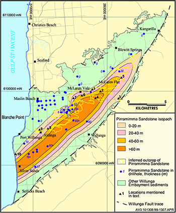
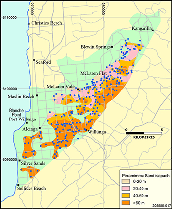
The investigations reported here have defined the extent of an extensive unconsolidated sand unit which attains a maximum thickness of over 110 m near the Willunga Fault (Fig 1), considerably thicker than that established by Fairburn (1998). The evidence suggests that this unit fits the Fairburn description of the ‘Pirramimma Sandstone’. Examination of over 300 drillers’ logs revealed sharp lateral transitions between the sand unit and the limestone of the Port Willunga Formation with no evidence of marine influence in descriptions of the sand intervals. Sharp vertical transitions were also observed, which is consistent with the description by Cooper (1977) of the type section of the ‘Pirramimma Sand Member’ in observation well WLG 42. The recognition of this discrete hydrostratigraphic sand unit has prompted a reappraisal of its stratigraphic position and age.
It is proposed that this unit be called the Pirramimma Sand as it is unconsolidated and, moreover, the use of the term ‘sandstone’ wrongly implies the unit is consolidated or lithified.
Age
Cooper (1979) regarded the ‘Pirramimma Sand Member’ as age equivalent with the Late Oligocene and Miocene calcareous sections of the Port Willunga Formation, noting that it could be easily distinguished from the underlying Port Willunga Formation. On the other hand, Fairburn (1998) argued that robust fossils in the Pirramimma Sand were derived from the Port Willunga Formation and reworked by fluvial processes (Fairburn 1998; Fig 2), actually placing the Pirramimma Sand in the Middle Pleistocene as a member of the Ngaltinga Formation, above the Hallett Cove Sandstone, the Burnham Limestone, the Seaford Formation and the Ochre Cove Formation, which is of Middle Pleistocene age as demonstrated by magnetostratigraphy (Pillans and Bourman 1996). Subsequently its position in the stratigraphic column was changed twice. Fairburn et al. (2010) inserted it between the Burnham Limestone and Kurrajong Formation in the Early Pleistocene, while in the latest Geology map of McLaren Vale Region (Aldam et al. 2019), it has been grouped with the Seaford Formation between the Hallett Cove Sandstone and the Burnham Limestone in the Upper Pliocene.
Barry Cooper (personal communication, 2000) commented that the wide scatter of fossils at different stratigraphic horizons in the Pirramimma Sand does not support the notion of reworking and was not aware of any reworking elsewhere in the Pleistocene succession. Furthermore, Cooper noted no unequivocal evidence of the Pirramimma Sand overlying the Plio-Pleistocene in the Willunga Basin.
Based on work carried out in the eastern St Vincent Basin near the Para Fault Scarp at Gawler, Lindsay (1988) correlated a sparsely fossiliferous marginal marine sand of Late Oligocene (Janjunkian) age with the quartzose, glauconitic, marginal sandy facies of the ‘Pirramimma Sand Member’ of the Willunga Embayment. Notably, fossil wood fragments, some with Teredo worm borings, were reported from both the Willunga Embayment and the eastern St Vincent Basin, whereas no fossil wood has been reported from the Quaternary sequences. The above data favour a pre-Pliocene age for the Pirramimma Sand as opposed to a Pleistocene age.
Hydrostratigraphy
For a number of years, groundwater was understood to occur in 4 major aquifers:
- Quaternary. Sands and interbedded clays forming shallow unconfined aquifers which are generally low yielding and provide mostly stock and domestic supplies, with limited extraction for irrigation.
- Port Willunga Formation. Cenozoic marine limestone and the ‘Pirramimma Sand Member’ which was considered a marginal sand facies of the limestone.
- Maslin Sands. Fine to coarse sands and clays of the North and South Maslin sands which are often carbonaceous. Separated from the overlying Port Willunga Formation aquifer by the low permeability Blanche Point Formation aquitard.
- Fractured rock. Neoproterozoic slates, quartzites, shales and limestone which form ranges to the east of the Willunga Fault and also along the Onkaparinga Gorge to the north.
It is recommended that a separate hydrostratigraphic unit called the Pirramimma Sand aquifer be recognised. In addition to the obvious differences in lithology and probably geological age, long-term water level monitoring has shown the Pirramimma Sand to act as an unconfined aquifer with very little seasonal variation. In contrast, the Port Willunga Formation shows seasonal water level variations of several metres because it is an aquifer confined and pressurised by the overlying Quaternary clays. A report on the assessment of the condition of the groundwater resources for a review of the Water Allocation Plan for the McLaren Vale Prescribed Wells Area has recently been prepared by the Department for Environment and Water (2022) and provides more detail.
Even though both aquifers have a high hydraulic connectivity with groundwater appearing to flow unimpeded between them, separate management approaches should be considered in the next review of the McLaren Vale Water Allocation Plan. This is because unconfined aquifers receive recharge from rainfall and, consequently, may be vulnerable to climate change. They may also have connection with surface water and support groundwater dependent ecosystems. Conversely, confined aquifers are generally not vulnerable to climate change and have no connection with surface water resources and ecosystems.
Structural geology
Previous interpretations of the structural geology have assumed that the Willunga Fault is the major control on the structure of the Willunga Embayment, with the basement topography gradually deepening from the northern margin of the basin toward the Willunga Fault where it reaches its maximum depth. The maximum vertical displacement of this fault is of the order of 500–600 m. However, several lines of evidence resulting from the drilling information, which is far more detailed than is normally available, has suggested that the northern margin could also be fault controlled.
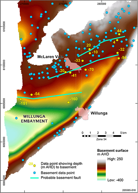
The basement surface elevation and the data points from drillhole logs shown in Figure 2 suggest the existence of possible basement faults. Selected basement elevation values in yellow are shown on the upthrown and downthrown sides of the proposed faults. Although Wolfgang Preiss (personal communication, 2021) contends that east–west faults are not prominent in the bedrock geology of the Mount Lofty Ranges, the evidence for the southernmost east–west fault seems to be compelling, with a 100 m vertical displacement of basement near the coast.
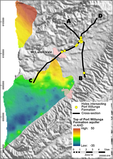
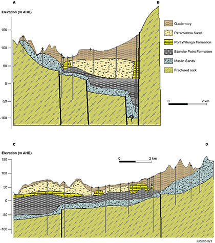
Interestingly, examination of drillhole logs has revealed isolated occurrences of the Port Willunga Formation limestones. Figure 3 shows the extent of the main body of limestone and the location of boreholes that record limestone in the drillers’ logs adjacent to the Willunga Fault and the probable faulted northern margin. Also shown are the locations of hydrostratigraphic cross-sections that are presented in Figure 4.
These isolated occurrences suggest the Port Willunga Formation limestones were originally deposited over a much larger areal extent than is observed today. Cross-section C–D shows the elevation of the remnants of Port Willunga Formation rising up-basin to the northeast to a maximum of 77 m AHD compared to a maximum value of about 30 m AHD for the main body of limestone to the southwest. Cross-section A–B suggests that there has been significant erosion and removal of limestone, possibly due to processes that led to the deposition of the fluvial Pirramimma Sand.
The cross-sections presented in Figure 4 also show further evidence of probable faulting on the northern margin of the Willunga Embayment. These sections necessarily have a large vertical exaggeration needed to show the subtle variations in thickness and elevation and suggest that basement faulting has controlled the extent of the Cenozoic marine sedimentation. In addition, the thickening of the Blanche Point Formation on the downthrown side of the faults (also apparent in section C–D), indicates ongoing gradual tectonic movement during the Late Eocene when the Blanche Point Formation was being deposited. If displacement across the faults had occurred post-deposition, similar thicknesses of sediments would be observed on either side of the fault.
This phenomenon has also been observed in the Adelaide Plains Sub-basin with Cenozoic units showing different thicknesses on either side of the Para Fault, again suggesting ongoing tectonic activity from the Eocene through to the Middle Miocene.
Conclusion
The data produced by this study suggest that the Pirramimma Sand as described herein is not a sand member of the Late Oligocene and Miocene calcareous sections of the Port Willunga Formation (Cooper 1979), nor is it a Pleistocene sandstone unit formed by reworking of the Port Willunga Formation (Fairburn 1998). The Pirramimma Sand should be recognised as a discrete stratigraphic deposit of pre-Pleistocene age and, as an unconfined aquifer, should have a different management approach from the adjacent Port Willunga Formation confined aquifer.
In addition, this study has provided new insights into the structural geology of the Willunga Embayment and has prompted a revision of the Pleistocene stratigraphy of the Willunga and Noarlunga embayments (Bourman et al. 2022, same MESA Journal issue). It suggests that the Port Willunga Formation was originally deposited over a much larger extent than can be seen today, and also demonstrates that in the basins marginal to the Mount Lofty Ranges, detailed stratigraphic data (thicknesses, extents and structure) can provide insights into the age and duration of major tectonic events.
Acknowledgements
Wolfgang Preiss (Geological Survey of South Australia, retired), Gabor Bekesi (Department for Energy and Mining) and an anonymous reviewer are thanked for constructive feedback which improved this paper.
References
Pillans B and Bourman RP 1996. The Brunhes/Matuyama Polarity transition (0.78 Ma) as a chronostratigraphic marker in Australian regolith studies. AGSO Journal of Geology & Geophysics 16(3):289–294.


