
Bernd H Michaelsen1, Adrian J Fabris1, John L Keeling1, David M McKirdy2, Laszlo F Katona1 and Les R Tucker1
1 Geological Survey of South Australia, Department of State Development
2 Centre for Tectonics, Resources and Exploration (TRaX), University of Adelaide
Peer reviewed (Department of State Development and externally)
Download this article as a PDF (10.4MB); cite as MESA Journal 81, pages 35–65
Introduction
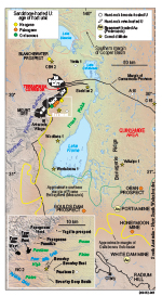
Figure 1
The Frome Embayment (Mesozoic) and Callabonna Sub-basin (Cenozoic) that overlie the Curnamona Province (Paleo-Mesoproterozoic) contain South Australia’s richest sandstone-hosted uranium deposits (Figs 1, 2). Arguably, this is the most prospective region in Australia for sandstone-hosted uranium and includes the Beverley deposit (discovered in 1969) and the world-class Four Mile East and Four Mile West deposits (discovered in 2005). All sites of known economic mineralisation are within 10 km of uraniferous granite outcrop that is part of the Mount Painter Inlier in the northern Flinders Ranges. The Beverley uranium deposit, a tabular ore body that does not form roll-front geometries (Wülser et al. 2011), is on the northeastern margin of the Poontana Trough (Figs 3, 4a), a 20–40 km wide depression extending for ~150 km NNE–SSW parallel to the northern Flinders Ranges and containing up to 390 m of Cenozoic sediments (Fabris, Gouthas and Fairclough 2010). The latest period of erosion of radiogenic Mesoproterozoic granite (including the Moolawatana Suite, Mount Neill Granite and Radium Creek Group; Fig. 2) commenced with rapid uplift of the northern Flinders Ranges c. 4 Ma (Quigley et al. 2007). This event is significant in terms of uranium supply to adjacent sedimentary basins. Airborne radiometric imagery (Fig. 5) shows that modern drainage transports radiogenic detritus from source regions in the northern Flinders Ranges onto the Frome Plains via channels incised across the Paralana High Plains. The detritus represents a large accumulation of uranium that is potentially available to be remobilised by meteoric water and thereby infiltrate local aquifers, from where the uranium is either further dispersed or precipitated and concentrated to form uranium deposits.
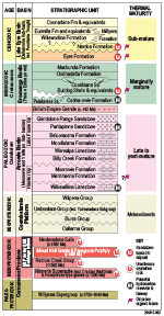
Figure 2
Transoil NL, part of the Oilmin–Transoil–Petromin consortium, which discovered uranium mineralisation at Beverley, measured concentrations of dissolved uranium in shallow aquifer waters collected from bores across the northern Poontana Trough (1974 Transoil data in Hore 2008). Heathgate Resources (1998) published similar data in the vicinity of the Beverley Mine. Values ranged from <1 ppb U near the Beverley deposit and Pepegoona deposits to a maximum of 900 ppb U in the area between Beverley and Lake Frome (Fig. 5). A corridor of groundwater with low uranium content (≤50 ppb U) lies within ~15 km of the range-front. We infer that reduction of dissolved uranium (as uranyl ions: UO22+) to form uranium ore is most effective within this corridor. By contrast, the Frome Plains, immediately northwest of Lake Frome, currently has no identified economic uranium mineralisation. Groundwater in the region, from available sparse data, is typically high in dissolved uranium (520–900 ppb), with the inference that subsurface reductants, capable of precipitating uranium from groundwater, are either more sparsely distributed or less effective. Organic matter (OM) preserved in the host sediments, together with pyrite derived from sulfate reduction by OM, are widely regarded as primary reductants for sandstone-hosted uranium (e.g. Spirakis 1996). The distribution of OM and its variable capacity to affect uranium reduction are considered prime factors that influence where uranium is deposited and are a key to understanding the region’s prospectivity for sandstone-hosted uranium. On this premise, investigations were commenced to evaluate the OM composition and distribution in sedimentary basins in the region.
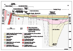
Figure 3
Sedimentary OM preserved in Cretaceous and Cenozoic sediments that overlie the Curnamona Province was examined and considered in terms of its potential to reduce and retain uranium. Potential uranium reductants also include migrating hydrocarbons that are known from historic surface-seepage (Sprigg 1959; Fig. 4). A geographic association is observed between known hydrocarbon seepage and anomalously elevated aquifer temperature in the area between the northern Flinders Ranges and the South Australia – New South Wales (SA–NSW) border, 100 km east of the Poontana Trough. In this investigation our objectives were to determine whether OM in the sediments is sufficiently H-rich to reduce uranium directly (Landais 1996) or, alternatively, whether it is feasible that hydrocarbons and hydrogen sulfide (H2S) generated from local indigenous sedimentary OM could have reduced dissolved uranium. The latter is a variant of the Jaireth, McKay and Lambert (2008) model that envisaged long-distance petroleum migration from deeply buried hydrocarbon kitchens within the Cooper and Eromanga Basins in northeast South Australia.
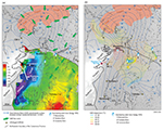
Figure 4a and b
The investigation involved re-logging cores from five widely spaced drillholes across the Curnamona Province; Skeleton 2, Yalkalpo 1, WC 2, Wooltana 1 and Wertaloona 1 (Fig. 1). Selected intervals were sampled for petrographic and geochemical analyses. Two additional cored holes, CBH 2 and C 15, which lie beyond the northern margin of the Curnamona Province (Fig. 1), were also included in the study. Using the resulting data, the roles of fixed uranium reductant (kerogen) versus mobile reductant (petroleum) were evaluated. All holes were scanned using HyLoggerTM to obtain spectral data for mineralogical logging.
Setting and regional lithostratigraphy
Sandstone-hosted uranium ore occurs at three different stratigraphic levels in the study area (Figs 1, 2). At the Beverley deposit it is present in sands of the Miocene Namba Formation (Heathgate Resources 1998), whereas the underlying Eocene Eyre Formation hosts the mineralisation at Four Mile East, Goulds Dam, Honeymoon, Oban and Pepegoona. Both formations are part of the Callabonna Sub-basin (Lake Eyre Basin). By contrast, at Four Mile West, the host lithofacies is a sandy glacial diamictite equivalent in age to the Cretaceous Bulldog Shale within the Frome Embayment of the Eromanga Basin (Cross et al. 2010; Stoian 2010; Michaelsen et al. 2012). The ultimate source of uranium for all the deposits on the Paralana High Plains was uraniferous Paleo- and Mesoproterozoic intrusions, related metamorphics and the Paleozoic British Empire Granite within the Mount Painter and Mount Babbage inliers on the northwestern margin of the Flinders Ranges (Figs 1, 2). By contrast, uranium-rich Mesoproterozoic granites of the Ninnerie Supersuite (Fig. 2) exposed as uplands in the Olary district along the southern margin of the Curnamona Province are the inferred source of paleochannel-hosted uranium (Fabris 2004; Fabris and Roach 2012) at Honeymoon, Goulds Dam and Oban. The Cenozoic Callabonna Sub-basin covers much of the Curnamona Province in South Australia. The underlying Mesozoic strata of the Frome Embayment have a more restricted distribution across the Curnamona Province, extending southwards to approximately the southern shore of Lake Frome (~31°15’, Fig. 1; Fabris, Gouthas and Fairclough 2010).
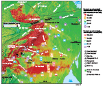
Figure 5
During tectonic uplift of the northern Flinders Ranges erosion of crystalline basement would invariably produce uraniferous scree, similar to that observed in present-day radiometric images (Fig. 5). This scree was reworked and incorporated within alluvial fans and interfluves on the margins of the ranges, as Willawortina Formation. In this semi-desert landscape, significant flows of uranium-bearing waters are periodically shed along ephemeral creek drainage. Infiltration of eastward-flowing, uranium-bearing water (Michaelsen et al. 2012) delivers significant quantities of dissolved uranium into aquifers of the subsurface Callabonna Sub-basin and underlying Frome Embayment.
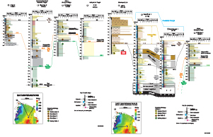
Figure 6a and b
Summary logs and lithostratigraphic correlation for the seven cored drillholes examined in this study are shown in Figure 6. The oldest ore-bearing unit, the Bulldog Shale, a grey marine mudstone (Krieg, Alexander and Rogers 1995), was intersected in Skeleton 2 near the northern extremity of the Poontana Trough, in Yalkalpo 1 above the Benagerie Ridge, and in C 15 close to the SA–NSW border (Fig. 1). The unit is typically grey siltstone with thin beds of ferruginised siltstone and subordinate fine-grained sandstone. Mineralogy is dominated by smectitic clays (montmorillonite) and kaolinite with subordinate white mica (Michaelsen et al. 2016), gypsum and carbonate (calcite>dolomite; Fig. 7a). At Yalkalpo 1 the uppermost 7.5 m is grey claystone deposited during the late Early Cretaceous marine transgression. The equivalent claystone is thinner (~1–2 m) at C 15.
The Eyre Formation is a fluviolacustrine sequence that is comprised of amalgamated sandy beds (both clean and carbonaceous), lignite and carbonaceous mudstone. The formation, deposited widely across the Lake Eyre Basin (Callen, Alley and Greenwood 1995; Fig. 2), is the basal unit of the Callabonna Sub-basin. Within the Callabonna Sub-basin, a higher proportion of sand is preserved north of latitude ~31°S (Hou et al. 2012a, b) and seams of lignite intercalate with sandy units in the northern Quinyambie area (Fig. 1). Eyre Formation was intersected in holes CBH 2, Skeleton 2, Yalkalpo 1 and C 15, however, sediment recovery was poor, especially where the sands are clean (clay-free). In addition to dominant quartz as fine to medium sand, spectral data, notably from Skeleton 2 (Fig. 7a), recorded abundant kaolin (well-crystalline kaolinite >> poorly crystalline kaolinite) with subordinate muscovite and minor smectite. Gypsiferous intervals are also present.
At C 15 there was no contiguous sediment recovery from Eyre Formation (Fig. 6) and so downhole geophysical logs were used to assist with lithostratigraphic reconstruction. A geographic trend (Fig. 6a) of increased oxidation from CBH 2 (west) to C 15 (east) is indicated by the relative increase of iron oxide. The Eyre Formation is thinnest (~23 m) at Yalkalpo 1, located above the Benagerie Ridge of Mesoproterozoic basement, and thickens eastward towards C 15 (45 m). This finding points to the existence of another depocentre, referred to here as the ‘Quinyambie Trough’, which continues eastward into New South Wales. Wooltana 1 and Wertaloona 1 were completed in lower Namba Formation, close to the top of Eyre Formation – based on the sediment thickness model of Fabris, Gouthas and Fairclough (2010).
Callen and Tedford (1976) nominated the Wooltana 1 drillhole as one of several type localities for the Namba Formation, and Callen (1977) assigned a ‘lower member’ and an ‘upper member’. At Wooltana 1, the basal Namba Formation comprises black indurated shale which differs from other Namba lithofacies in being lithified and competent, and has a reliable palynological date of c. 23 Ma (earliest Miocene: Martin 1990). Petrographic and geochemical characteristics (discussed below) confirm the black shale to be a lamosite-type oil shale (cf. Hutton et al. 1980). The lamosite comprises the lowermost bed of Callen’s (1977) ‘lower member’. Immediately above the oil shale, distinctive beds comprising in part whitish palygorskitic dolomite may be correlated with a similar interval in Wertaloona 1. The stratigraphic position of this calcareous layer appears to be equivalent to that reported elsewhere as ‘Namba carbonate’ (e.g. Marsland-Smith et al. 2011).
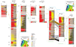
Figure 7a and b
The ‘lower member’ (sensu Callen 1977) of the Namba Formation appears to be preserved across the entire study area and this is supported by mineralogical interpretation of HyLogger data (Fig. 7; App. 1) that indicates cyclic deposition with variations in the relative abundance of smectite to illite. Lithostratigraphic correlation within the Poontana Trough (i.e. between Wooltana 1 and Wertaloona 1; Fig. 4) is based on the presence of the lower palygorskitic dolomite unit.
The ‘upper member’ of the Namba Formation contains less smectite but has a corresponding increase in white mica (phengite and phengitic illite) above the uppermost (main) aquitard (Michaelsen et al. 2016). The ‘upper member’ appears to be present only within the Poontana Trough and was intersected at Wooltana 1 and Wertaloona 1 where its thickness is 75.6 and 85.2 m, respectively. The thicker intersection in Wertaloona 1 may reflect a more southerly shift in the depocentre between early Namba time (represented by oil shale near the base of the ‘lower member’) and late Namba time (represented by the ‘upper member’). Alternatively, the ‘upper member’ was eroded in the north during progradation of the Plio-Pleistocene alluvial fans of the Willawortina Formation. This alluvial apron invariably removed the uppermost layers of the underlying Namba Formation, especially close to the range-front as demonstrated in WC 2 where the ‘upper member’ is absent.
At Yalkalpo 1, the Namba Formation (58 m thick) is logged as a condensed sequence that increases in thickness towards the east where some 78 m is preserved within the Quinyambie Trough at C 15. This indicates that the Benagerie Ridge was an area of limited accommodation space throughout deposition of the Namba Formation.
The Willawortina Formation, comprising mostly gravels and sands, systematically decreases in thickness and grain size from 102 m at WC 2 at the Beverley deposit ~10 km from the range-front of the Mount Painter Inlier, to 72 m at Wooltana 1, 22 km from the inlier, and is only 22 m thick at Wertaloona 1, 75 km from the Mount Painter Inlier, where it is dominated by silts and sands. At Yalkalpo 1, situated above the Benagerie Ridge and 75 km from the Mount Painter Inlier, the Willawortina Formation is only ~6 m thick; at C 15 (124 km from the range-front) net accumulation of post-Namba Formation strata accounts for only ~3 m of the sedimentary section.
In summary, erosion of the Namba Formation during the Plio-Pleistocene was minor at both Yalkalpo 1 and C 15, but more extensive close to the ranges. Notwithstanding, the Namba Formation is thickest in the Poontana Trough where an ‘upper member’ is preserved.
Organic facies and their potential relevance to the reduction of uranyl ions
The diversity of OM preserved in the ore-bearing Cretaceous, Paleogene and Neogene units overlying the Curnamona Province was investigated using incident-light microscopy. Identification of their maceral assemblages in turn allowed the recognition and mapping of different organic facies, based on the concept of organic facies as described by Jones and Demaison (1980).
Dissolved U6+ (as uranyl ions: UO22+) can precipitate as a mineralised phase (e.g. U4+ in uraninite: UO2) via a reduction reaction of the form 2(RH) + UO22+ → 2R0 + 2H+ + UO2 (Nakashima et al. 1984), where R is an organic moiety. Therefore, oxidation of OM is concomitant with dehydrogenation and H2 formed via dehydrogenation is, in its own right, capable of U6+ reduction. It follows that H-rich OM (i.e. liptinite) is a high-quality uranium reductant. Such OM, of herbaceous and algal origin, is also a high-quality source material for petroleum (Tissot and Welte 1984). Conversely, upon maturation, H-poor OM (inertinite) is unlikely to generate significant quantities of petroleum, particularly liquid hydrocarbons, and is therefore less capable of reducing dissolved uranium. Landais (1996) argued along similar lines, noting in particular that dehydrogenation of OM occurred in parallel with decomplexation of uranyl to form ore. Moreover, in situ anaerobic bacterial reworking of detrital OM can enhance its reductive potential, and the H2S co-produced by sulfate-reducing bacteria provides additional potential to reduce U6+.
In summary, mapping organic facies within a sandstone-hosted uranium province is a logical and pertinent enterprise. Its purpose is to reduce uranium exploration risk by demarcating stratigraphic intervals and areas where the best potential uranium reductant (a H-rich organic facies) is developed. To that end, additional laboratory techniques were used, viz. Rock-Eval pyrolysis and gas chromatography - mass spectrometry (GC-MS), both routinely used in the petroleum exploration industry to characterise hydrocarbon source rocks and their extractable bitumen.
Methodology
Organic petrology
Blocks of sediment core were cut perpendicular to bedding, mounted in hot-setting Araldite resin and polished for petrographic analysis. These blocks were examined using a Leitz ORTHOLUX II microscope through oil immersion lenses, in both incident white light and under ultraviolet excitation (fluorescence-mode). A Wild Photoautomat MPS Spot camera was used to photograph lignite and dispersed organic matter (DOM) through a K510 (nm) barrier filter and BG12 and BG38 excitation filters.
Rock-Eval pyrolysis and GC-MS
A subset of core samples (n = 33) was submitted to Geotechnical Services Pty Ltd, Perth, for geochemical analysis. This technique measures, among other things, the total organic carbon (TOC) content of the sample and the relative hydrogen content of its insoluble kerogen fraction. The latter parameter, expressed as a hydrogen index (HI), is calculated by dividing the amount of hydrocarbons released via pyrolytic destruction of the kerogen (S2, in mg) by the TOC content. Comprehensive descriptions of the technique, and guidelines to the interpretation of results are given in Peters (1986) and Langford and Blanc-Valleron (1990).
GC-MS analysis was done on the saturated hydrocarbons isolated from two samples: black shale (base Namba Formation) recovered from Wooltana 1 and lignite from the Eyre Formation in A 10 (Fig. 1). Analysis by GC-MS provided details on the hydrocarbon biomarker composition and level of thermal maturity of both samples. Details of the conditions used for sample preparation, extraction, fractionation and GC-MS analysis are provided in Appendix 2.
Results
Organic petrology
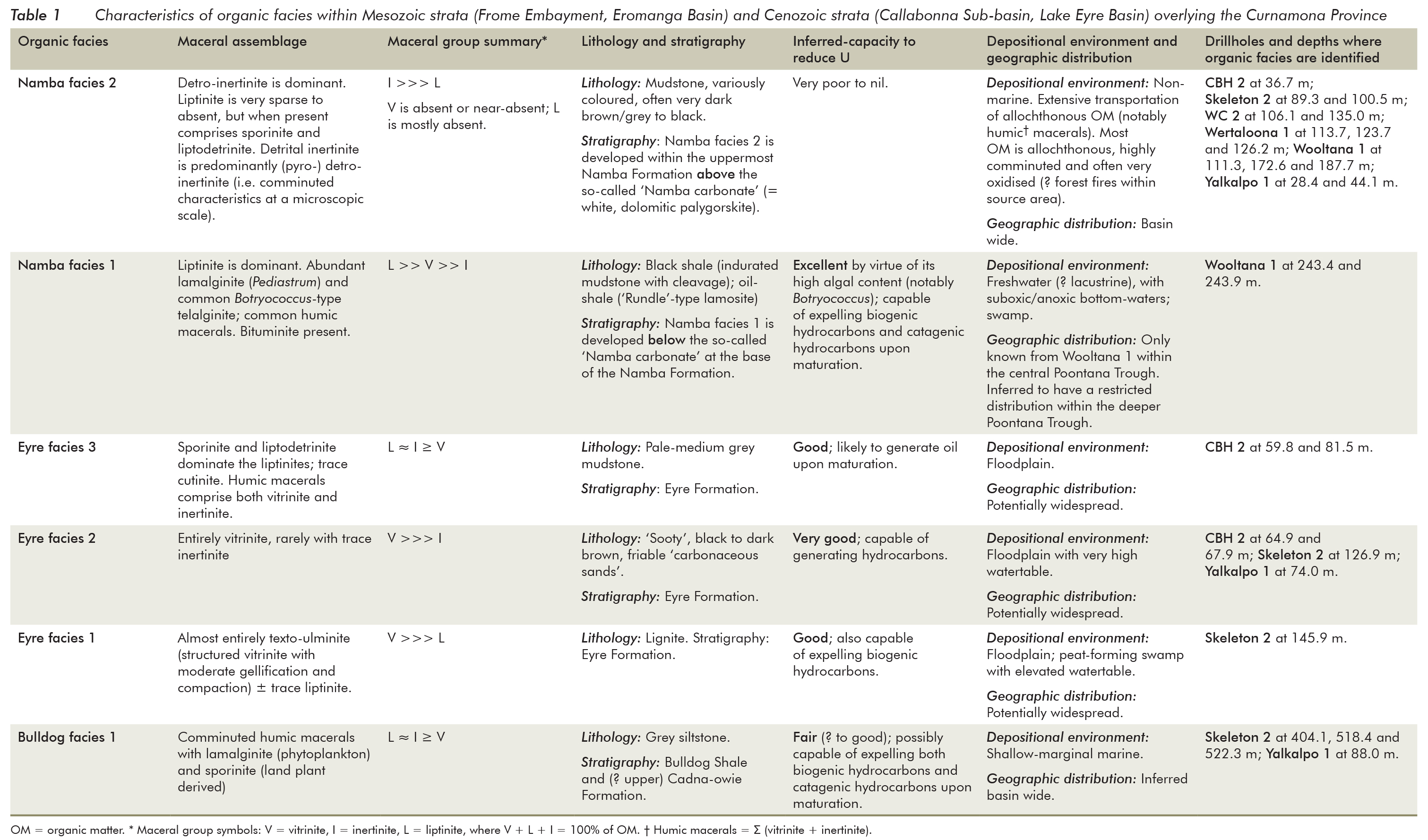
Table 1
Incident-light petrography identified six organic facies (Michaelsen and Fabris 2011, 2014): one in the Bulldog Shale, three in the Eyre Formation and two in the Namba Formation. The characteristics of each are summarised in Table 1. DOM and coal are described here using standard coal maceral terminology (AS 2486.2–1989: Standards Australia 1989). Photomicrographs of representative fields of view for each organic facies are shown in Figure 8. Each field of view is illustrated by a pair of photomicrographs, one in incident white light (left) and the other fluorescence-mode (right). Fluorescence-mode microscopy is a powerful tool with which to study sedimentary OM because its oil-prone H-rich constituents (members of the liptinite maceral group) exhibit autofluorescence (Stach et al. 1982).
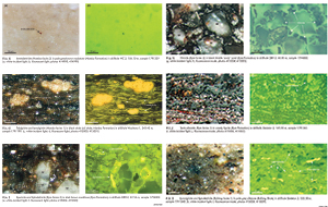
Figure 8a to l
Bulldog facies 1 (Figs 8k, l) is developed within grey siltstone of the Bulldog Shale and also in silty beds of the Cadna-owie Formation. It comprises lamalginite (phytoplankton), comminuted humic macerals (i.e. Σ vitrinite + inertinite), and herbaceous H-rich material (mainly sporinite). Vitrinite is only a minor component, and its abundance is subordinate to both liptinite (H-rich) and inertinite (H-poor). The geographic distribution of this facies is inferred to be widespread across the Eromanga Basin (cf. McKirdy et al. 1986).
Eyre facies 1 (Figs 8i, j) is preserved as lignite. Deposited in a peat swamp with a high watertable, this organic facies is composed of texto-ulminite with minor herbaceous liptinite.
Eyre facies 2 (Figs 8g, h) is developed within sooty, black to dark brown friable ‘carbonaceous sand’, deposited upon a floodplain with a high watertable and proximal to interdistributary channels. It comprises vitrinite, with or without trace quantities of inertinite.
Eyre facies 3 (Figs 8e, f) is preserved in pale-grey mudstone that was deposited upon floodplains and within oxbows; consequently its distribution is likely to be basin-wide. It is composed of DOM in which liptinite and inertinite are co-dominant over vitrinite. The liptinite comprises mainly sporinite, liptodetrinite and trace cutinite.
Namba facies 1 (Figs 8c, d) occurs within lacustrine shale near the base of the Namba Formation at Wooltana 1 (Figs 6, 7b; App. 1.3) located near the depocentre of the Poontana Trough (Fig. 4b). Under the microscope the shale’s DOM is demonstrably sapropelic with a maceral assemblage comprising lamalginite (Pediastrum), Botryococcus-type telalginite and varying amounts of bituminite, underscoring the oil-prone character of this unit. This maceral assemblage is similar to that reported for the Paleogene Rundle oil shale in Queensland (a lamosite: Hutton et al. 1980). In hand specimen, the Namba ‘oil shale’ is black and indurated with (? bedding-parallel) cleavage, subvertical ovoid pyrite concretions and a dusting of fine pale-grey/yellow sulfurous ash.
Namba facies 2 (Figs 8a, b; Apps 1.1, 1.2, 1.3) is developed within brown claystone and argillaceous siltstone characteristic of the upper Namba Formation. It is composed of highly comminuted inertinite (inertodetrinite and micrinite) with very sparse sporinite and liptodetrinite. It appears to be ubiquitous throughout the Poontana Trough and beyond. The host rocks contain ferrous iron and manganese (Callen 1975; Alley 1998) that account for their dark brown to black colour when fresh and water-saturated.
Rock-Eval pyrolysis
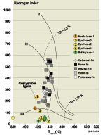
Figure 9
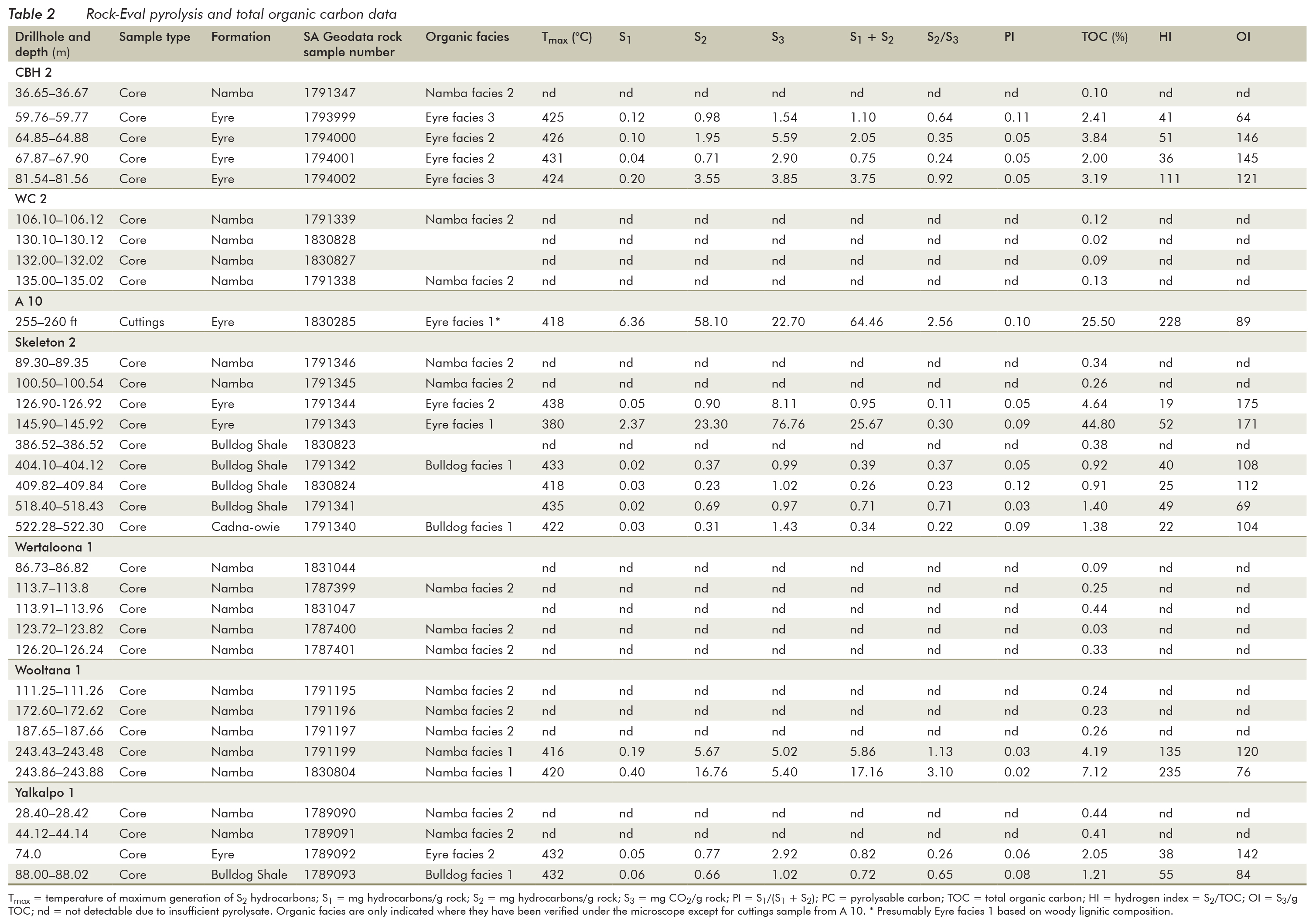
Table 2
The data obtained by Rock-Eval pyrolysis are presented in Table 2 and Figure 9. Although clearly oil prone by virtue of their maceral compositions, two samples of Namba facies 1 shale examined under the microscope have hydrogen indices (HI = 135 and 235; Table 2; Fig. 9) that are comparable to or lower than those of Eyre facies 1 lignite (HI = 228). This anomalous finding is explained below. Thus, based on its organic petrology and correcting for the mineral matrix effect, Namba facies 1 can be expected to comprise thermally immature Type I-II kerogen (Fig. 9). While the lignite at A 10 (Eyre facies 1) is likewise clearly submature for liquid hydrocarbon generation (VR <0.4%; Figs 9, 10), its HI value reveals it contains oil and gas-prone Type II-III kerogen. Thus, both organic facies, termed Namba facies 1 and Eyre facies 1 are potentially high-quality uranium reductants.
Biomarker hydrocarbons
Total ion chromatograms and a partial mass fragmentogram (m/z 191) from GC-MS analyses of the saturated hydrocarbon fractions of extracts from oil shale (Wooltana 1: 243.43–243.48 m core, Namba facies 1) in the Poontana Trough and lignite (A 10: 255–260 m cuttings, Eyre facies 1) in the Quinyambie Trough are compared in Figure 10. The oil shale (TOC = 4.19%; HI = 135) has a bimodal n-alkane profile ranging from C13 to C33, with maxima at C19 and C27. The more abundant shorter chained homologues (C13–C22) are derived from algal and bacterial OM, whereas those in the C23+ range exhibit a marked odd–even predominance reflecting a lesser input from land plants. By contrast, the n-alkane profile of the lignite (TOC = 25.5%; HI = 228) from the Quinyambie Trough is almost totally lacking homologues inherited from algal and bacterial OM. Rather it is dominated by C23+ n-alkanes (maximum at C29) with a much greater odd–even carbon number predominance than those in the Namba oil shale. The major contributors of OM to the lignite therefore were vascular higher plants.
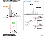
Figure 10
Triterpenoids are pentacyclic hydrocarbons of bacterial origin typically containing between 27 and 35 carbon atoms. Resolved by GC-MS and best identified in the m/z 191 mass fragmentogram, the main triterpane identified in both the oil shale and the lignite is C31 17α,21β-homohopane. In both samples the 22R stereoisomer predominates over 22S. Moreover, the thermally unstable C27 moretane, 17β-22,29,30-trisnorhopane (17β-TNH), is a major component of these sediment extracts and almost co-dominant with 22R homohopane in the oil shale of Namba facies 1. Despite the area’s high geothermal gradient, the predominance of both 17β-TNH and 22R 17α,21β-homohopane attests to the thermal immaturity of both samples and demonstrates that neither have entered the oil window for their respective OM types. Furthermore, the greater abundance of 17β-TNH relative to homohopane in the oil shale may indicate greater (anaerobic) bacterial reworking of the primary algal and higher plant OM in its precursor gyttja (organic mud), a proposition consistent with the identification of bituminite in Namba facies 1 (Table 1).
Discussion
Organic facies and lithostratigraphy
Prior to this investigation, no systematic work had been reported that specifically examined OM in sediments of the Lake Frome region from the viewpoint of their uranium reduction potential. A paper by Curtis, Brunk and Binks (1990) indicated that ‘fixed humic matter such as lignite’ and ‘mobile humic petroleum-like gelatinous materials’ are associated with uranium deposits in the area, but these cryptic materials were not retained for further study. Carbonaceous lithologies in the Namba Formation have been implicated in uranium reduction at Beverley (e.g. Heathgate Resources 1998). However, as first noted by Callen (1975) and confirmed by this investigation, claystones of the Namba Formation are mostly not carbonaceous. Rather, as stated above, the argillaceous lithofacies of the Namba Formation contains manganese and ferrous iron. Observation of drying of freshly recovered claystone core, obtained during the 2011 drilling campaign by Cameco Australia Pty Ltd and Uranium Equities Ltd in areas east of Lake Blanche, showed the initially dark brown-black and water-saturated claystone changes colour to pale-medium maroon and shades of pale brown. Similar observations have been made during development drilling at Honeymoon Mine in the southern Callabonna Sub-basin. While the basal Namba Formation was laid down within a suboxic to anoxic Mg-rich freshwater lacustrine system (Alley 1998), the prevailing oxic conditions during deposition of the more widespread upper part of this unit precluded the preservation of autochthonous algae in the mudstones hosting Namba facies 2.
With the exception of the oil shale unit intersected by the Wooltana 1 drillhole, DOM within the Namba Formation is preserved as Namba facies 2 comprising comminuted inertinite equivalent in composition to Type IV kerogen (HI <40). If Namba Formation samples analysed in this study are typical of the unit within Beverley deposit, it is difficult to explain how significant amounts of uranium mineralisation at that locality (pre-mined resources of ~7000 t) could have been precipitated by detrital in situ organic reductant.
Plant fragments and larger pieces of carbonised wood have been described from the locally named ‘Alpha mudstone’ (i.e. the uppermost mudstone of the Namba Formation: Heathgate Resources 1998, pp. 6–9), however, no such material was observed in the seven regional core holes examined in this study (Fig. 1). The rarity of megascopic organic detritus in the Namba Formation is consistent with the notion that humic coal (lignite) was not deposited during this interval. The absence of lignite and lignitic debris is further supported by systematic regional mapping by the Geological Survey of South Australia on MARREE and CALLABONNA 1:250 000 map sheets (Malcom Sheard, Geological Survey of South Australia, pers. comm. 2010) and more northern areas beyond the flanks of the Flinders Ranges. Samples of Namba Formation microscopically examined for organics were with one exception (Wooltana 1, 111.3 m) from the ‘lower member’ in which the mineralogy is largely unaltered, as indicated by a predominance of smectite over well-crystalline kaolinite (Fig. 7a, b; App. 1.1). The likelihood of preserving unoxidised (i.e. non-inertinitic) DOM above the main aquitard in Namba Formation is considered to be much lower. In this upper zone, poorly crystalline kaolinite, and white mica/illite are more common (Fig. 7b; Apps 1.2, 1.3) and are interpreted to have formed by alteration of smectic clays through repeated infiltration of meteoric water.
In contrast to the organically barren lithologies of the Namba Formation above the lower palygorskitic dolomite aquitard (Fig. 7b), the restricted lowermost unit (‘basal unit 1’ of Martin 1990) consists of black shale (lamosite oil shale; Namba facies 1). At Wooltana 1 this unit comprises 8 m of oil shale (or sapropelite) that accumulated as gyttja in the stagnant bottom waters of ‘Lake Namba’, the initial depocentre of this formation. It contains autochthonous Botryococcus-type telalginite and lamalginite derived from Pediastrum, both suggesting freshwater limnic deposition. Gymnospermous pollen is also preserved, as are spores from the fern Gleichenia (Martin 1990). The water column of ‘Lake Namba’ was more anoxic or dysoxic than the peat-forming environment that gave rise to the lignite of Eyre facies 1 and the carbonaceous sands of Eyre facies 2. During early diagenesis of what later became black shale, anaerobic bacterial decay (putrefaction: Stach et al. 1982) transformed organic constituents within the gyttja into hydrogen-rich bituminous sapropel. The black shale grades upwards into grey siltstone, possibly in response to a shallowing water column and increasingly oxic conditions.
The black shale in Wooltana 1, the only lithified unit within the Callabonna Sub-basin sampled by the cored drillholes, is overlain by silty claystone comprising smectite and kaolin-rich layers interbedded with yellowish white palygorskitic dolomite-rich layers. This indicates that after accumulation of the basal gyttja, ‘Lake Namba’ deepened and saline alkaline conditions prevailed. Immediately above this calcareous unit are several poorly developed fining-upwards sedimentary packages (Fig. 6; App. 1.3). These cycles are possibly equivalent to sedimentary subunits informally described by Heathgate Resources Pty Ltd. For example, the informal term ‘Namba carbonate’ (Marsland-Smith et al. 2011) has been used for a carbonate unit that appears to be equivalent in stratigraphic position to the lower palygorskitic dolomite beds at Wooltana 1 and Wertaloona 1.
At the Beverley deposit, the main sandstone-hosted uranium occurs in the uppermost sedimentary cycle of Namba Formation (Heathgate Resources 1998) within the ‘Beverley sand’ of the ‘Beverley sequence’. Mineralisation is also developed within the underlying ‘Alpha sequence’ at the Beverley East satellite deposit (Marsland-Smith et al. 2011). Wülser et al. (2011) showed that the main uranium-bearing phases within the mineralised zone in WC 2 (Fig. 6b) are coffinite-uraninite bearing nodules typically 1 to 2 µm in diameter. Using a scanning electron microscope they determined that the coffinite–uraninite mineralisation is preserved as nodules comprising bacterioform aggregates indicating the important role of microbes in the reduction of uranyl and the formation of uranium ore in at least part of the deposit.
The lithostratigraphy of Wertaloona 1 (Fig. 6; App. 1.2) indicates that at least 25 m thickness of medium-grained sand was deposited on the palygorskitic dolomite beds, the latter forming part of the lower aquitard. These permeable sands present uranium explorers with ‘lower member’ targets within the deeper Poontana Trough.
The distinctive palygorskitic dolomite and dolomitic claystone package that sits above the oil shale in Wooltana 1 is an important lithostratigraphic marker. At Petratherm’s Paralana 2 geothermal hole (Fig. 4) the lowermost lithofacies of the Namba Formation is similar to that developed at Wooltana 1, some 46 km further south in the Poontana Trough (Fig. 4a). At Paralana 2 the basal Namba Formation comprises ~9.5 m of mudstone (argillaceous sediment similar to the oil shale) beneath nearly 40 m of white to off-white limestone interbedded with claystone (Beach Petroleum 2010). Thus, the oil shale in Wooltana 1 may be correlated with the basal claystone in Paralana 2. Both are mud-dominated units, the gyttja at Wooltana 1 having formed near the basin depocentre whereas the claystone at Paralana 2 may have developed on the margins of the same lacustrine system. From this model we predict widespread deposition of oil shale within the deeper parts of the Poontana Trough, including possibly at Wertaloona 1 beneath total depth.
The present basin-wide study highlights the fact that the ‘upper member’ of Namba Formation is only preserved at Wertaloona 1 and Wooltana 1 (i.e. within the Poontana Trough); or at least it is not recognised elsewhere. The base of the ‘upper member’ is a thin conglomerate, and the member fines upwards with more dolomitic palygorskitic claystone preserved within the upper portion of the local aquitard (Figs 6, 7b). As previously discussed, the ‘upper member’ may have been more widespread across the western margin of the basin but was subsequently eroded by prograding alluvial fans that developed during recent uplift of the northern Flinders Ranges (c. 4 Ma). Alternatively, the ‘upper member’ was restricted to the deeper and more distal Poontana Trough where sufficient accommodation space developed during sedimentation in the early to mid-Miocene.
Shallow petroleum systems within the Frome Embayment and Callabonna Sub-basin
The Poontana Trough and northern Finders Ranges are located within the ‘South Australian heat flow anomaly’, the southwestern extension of a volume of crust centred on the Cooper Basin (Humphreys et al. 2013, fig. 3), with anomalously high temperature gradients due to radiogenic heat emanating from Proterozoic granite (Neumann, Sandiford and Foden 2000; McLaren et al. 2003).
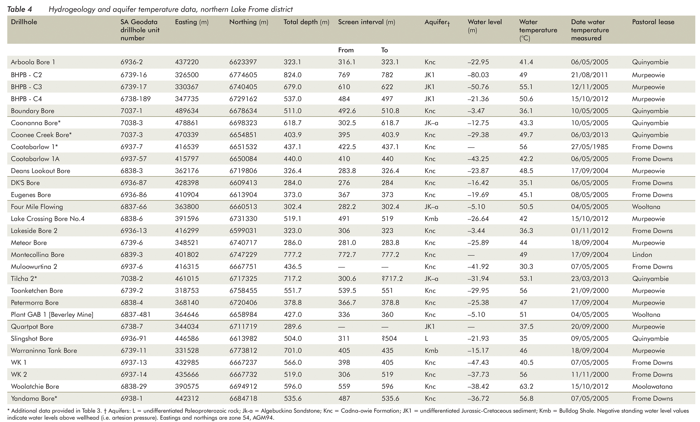
Table 4
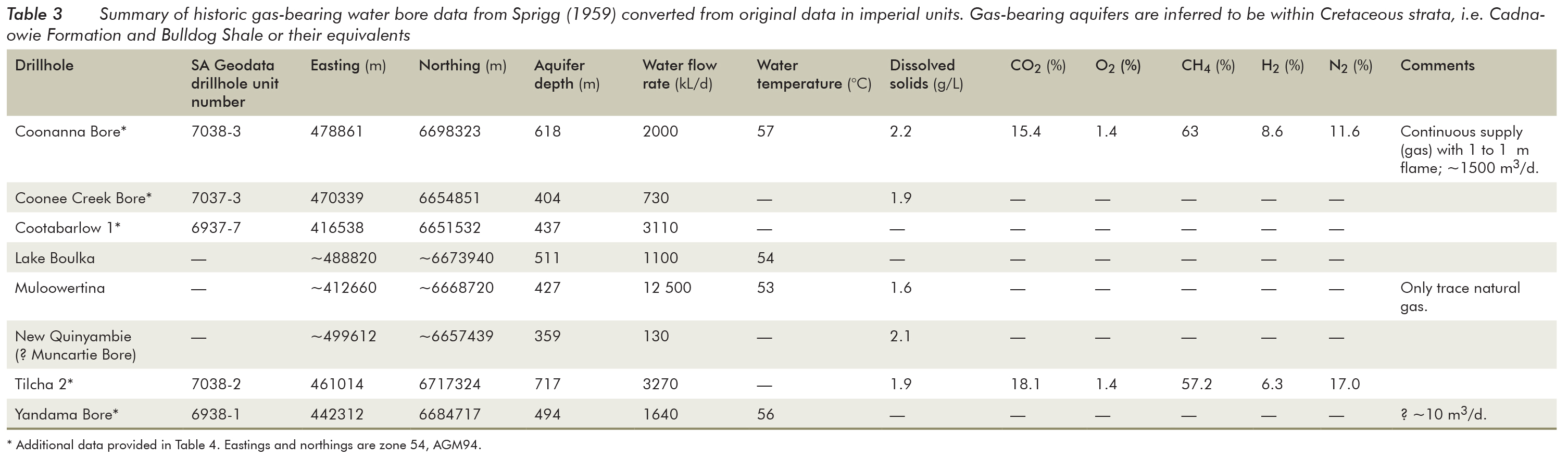
Table 3
Ten kilometres east of Beverley deposit, an exceptional geothermal gradient of ~80 °C/km is recorded in the post-Cambrian succession in Petratherm’s Paralana 2 hole (Figs 1, 3, 4a). Here, a temperature of 58 °C was measured at ~490 m, a depth that corresponds to the base of Bulldog Shale. Water of this temperature is produced from beneath the Bulldog Shale (i.e. within the Cadna-owie Formation) throughout a wide area of the northern Poontana Trough (Sprigg 1959; Fig. 4b; Tables 3, 4), extending eastward across the Quinyambie area and presumably beyond the SA–NSW border. Gas-bearing pastoral bores producing water at ~55 °C were historically sited along conspicuous straight creek drainage (e.g. Yandama Creek; Fig. 4; Table 3), the inference being that creek drainage pattern was controlled by recent fault reactivation. Temperatures of 53–57 °C for these aquifer waters are significant because they lie within the early ‘oil window’ and correspond to the onset of liquid hydrocarbon generation (Tissot and Welte 1984).
Archival water temperature data reported by Sprigg (1959; Table 3) and other data, in particular a Great Artesian Basin (GAB) temperature of 63 °C from ~350 m in Woolatchie water bore (Table 4), demonstrate that the lowermost Bulldog Shale will have entered the window for liquid hydrocarbon generation over a vast area surrounding the northern Flinders Ranges. Furthermore, in the vicinity of the Poontana Trough and possibly in the Quinyambie Trough east of the Benagerie Ridge, the overlying Eyre and Namba Formations may also be sufficiently mature to form hydrocarbons, although core samples analysed by Rock-Eval pyrolysis (Table 2) clearly indicate thermal immaturity (vitrinite reflectance, VR <0.5%) when plotted on a Tmax versus HI crossplot (Fig. 9). Kerogen derived from microbial biomass and preserved as bituminite, part of the maceral assemblage comprising Namba facies 1, is more labile than kerogen derived from lignin and cellulose-derived OM (Cook 1986). This microbial kerogen will have a higher petroleum yield, especially liquid hydrocarbons, than OM preserved as vitrinite and inertinite (Tissot and Welte 1984). It is therefore reasonable to infer that the onset of oil generation for the bituminite of Namba facies 1 is <0.5% VR and even as low as 0.4% VR. The main oil generation stage for such bacterial OM is considered to be between 0.5 and 0.8% VR (Cook 1986), a level of thermal maturity comparable to that of Mesozoic strata in the northern Poontana Trough (based on temperatures recorded in Paralana 2 geothermal drillhole and Woolatchie water bore). It should be cautioned that the most abundant oil-prone macerals in Namba facies 1 are of algal derivation, viz. lamalginite (Pediastrum) and telalginite (Botryococcus). In contrast to bacterially derived OM, the latter telalginite is not expected to enter the oil window until ~0.65–0.7% VR (Cook 1986; Powell 1986; Powell 1987). Therefore the Namba Formation at Wooltana 1 is clearly not within the conventional oil window with respect to its primary maceral composition.
Paralana Hot Springs discharge surficial water at ~60 °C (Mawson 1927; Brugger et al. 2005) signifying that even higher geothermal gradients are likely within the Paralana Embayment (i.e. beneath the Paralana High Plains: Fig. 1) where Mesozoic and Cenozoic sediments are in fault-contact with uraniferous crystalline basement. Here the thermally less labile Type III kerogen preserved within the Eyre Formation (Fig. 9) may also have generated liquid hydrocarbons and/or may have released biogenic methane.
The absence of H-rich OM within the ‘upper member’ of Namba Formation in drillhole WC 2 within Beverley deposit implicates an external source of reductant to form the uranium mineralisation. One possibility is petroleum, sourced from deeper in the Poontana Trough. The migration of petroleum formed in this way would be facilitated by faults, including those that intersect the uranium-fertile aquifer in the vicinity of Beverley. Biodegradation of hydrocarbons in this relatively shallow and well-confined aquifer (i.e. sand within ‘Beverley sequence’; Heathgate Resources 1998) would provide an ideal environment for the reduction of uranyl and ongoing precipitation and preservation of uranium ore.
Alternate sources of hydrocarbons
The case outlined above is that unconventionally shallow petroleum systems could generate hydrocarbons in areas where the geothermal gradient was sufficiently high and appropriate source rocks were present, as is the case in the Frome Embayment, especially within the northern Poontana Trough. Notwithstanding, long-distance hydrocarbon migration from more conventional and deeply buried (>3 km) source rocks may also be possible. This was envisaged in the model proposed by Jaireth, McKay and Lambert (2008) with province-scale migration of hydrocarbons from the Cooper and Eromanga Basins in the northeast of South Australia, southward towards the Flinders Ranges and the Beverley area.
Figure 11
Long-distance hydrocarbon migration beyond the margin of the Cooper Basin has been substantiated using hydrocarbon biomarker studies of oil at Mulapula 1 drillhole (Fig. 11); based on low abundance of Araucariacean (Jurassic) biomarkers in the aromatic hydrocarbon fraction of oil from Mulapula 1, Michaelsen (2002) recognised long-distance (≥70 km) migration from a pre-Jurassic hydrocarbon kitchen in the Cooper Basin, westward into the Namur Sandstone (Eromanga Basin) on the Birdsville Track Ridge. Recognition that the Mulapula oil represents, at least in part, expulsion from a pre-Jurassic age source rock demonstrates the fact of long-distance hydrocarbon migration and focusing at a trap site within moderately shallow aquifers of the overlying Eromanga Basin.
The pre-Jurassic component of the Mulapula oil may have been derived from any one or a combination of several Permo-Triassic sources rocks within the Cooper Basin sequence (App. 3). Moreover, there are demonstrable hydrocarbon kitchens within the Jurassic to Early Cretaceous Poolowanna, Birkhead and Murta Formations of the Eromanga Basin (Michaelsen and McKirdy 2001; Michaelsen and McKirdy 2006). The latter appears capable of generating hydrocarbons from relatively labile bacterially modified OM (bituminite), in some cases at maturities no greater than 0.55% VR, i.e. at temperatures little above 55 °C. Organic facies preserved within Murta Formation (Michaelsen 1986; Michaelsen and McKirdy 1989) are in some respects similar to Namba facies 1 in that they comprise Botryococcus-type telalginite and bituminite. Calculated maturities and biomarker chemistry of Murta-reservoired crudes indicate that hydrocarbon generation within the Murta Formation occurred from relatively labile kerogen, early in the oil window (0.5–0.7% VR: Michaelsen and McKirdy 1989; Powell et al. 1989) due to intense bacterial reworking of lignin and cellulose-derived OM early in its diagenetic history.
The aquifer system of the Great Artesian Basin (GAB) can be defined as the sum of the artesian units between the uppermost Poolowanna Formation and the lowermost Bulldog Shale (App. 3). GAB flow-vectors above the Tinga Tingana Trough (Fig. 4a) align towards a piezometric depression centred 20 km east of the southern shores of Lake Blanche. The axis of the piezometric depression coincides approximately with the Lake Blanche – Dry Creek – Lake Frome drainage axis (Fig. 11). As such, modern Lake Frome is located at a groundwater confluence where flow from the eastward-flowing GAB, recharged around the eastern margin of the northern Flinders Ranges, meets westward-flowing GAB recharged in the Great Dividing Range of eastern Australia (Habermehl 1986). Along this axis, there is potential for upward leakage of artesian water containing dissolved hydrocarbons into shallow aquifers of the Callabonna Sub-basin, similar to the postulated leakage of hydrocarbons at the Big Lake uranium prospect (Fig. 11). That some artesian water bores within Lake Frome district are completed in Eyre Formation (P Magarey, Department of Environment, Water and Natural Resources, pers. comm. 2012) reinforces this notion, as do artesian mound springs concentrated in the vicinity of the eastern shore of Lake Frome. Moreover, historic data from Sprigg (1959; Table1) suggests an association between elevated GAB temperatures and the presence of hydrocarbon gas, in particular along strike of the anomalously linear drainage at Yandama Creek (Fig. 4a).
Within the stacked Warburton, Cooper and Eromanga Basins, the most shallow-lying and demonstrably effective petroleum source is the Murta Formation (Michaelsen and McKirdy 1989; Powell et al. 1989). This predominantly freshwater lacustrine unit was deposited during the Early Cretaceous over large areas of South Australia and Queensland (Zoellner 1988). It is partly self-sourcing and is likely to have contributed to hydrocarbon accumulations within the overlying Namur Sandstone and Cadna-owie Formation (App. 3). This is notably the scenario above the southwestern margin of the Cooper Basin where Cretaceous hydrocarbons are mixed with oil sourced from the Cooper Basin and the deeper Warburton Basin (Arouri et al. 2004; Arouri and McKirdy 2005). The older Birkhead Formation (mid-Late Jurassic), a better source rock (Michaelsen and McKirdy 2006) than the Murta Formation, is also capable of generating hydrocarbons that could migrate into the overlying sequence. In South Australia, hydrocarbons partly sourced from the Murta Formation and potentially the Birkhead Formation are reservoired in the vicinity of the Murteree Ridge that separates the Nappamerri and Tenappera Troughs (Fig. 11). Hydrocarbons that have escaped entrapment in this area may have been swept southwards into the Lake Blanche – Lake Callabonna area (Fig. 1).
Shallow petroleum systems north of the Frome Embayment
The approximate extent of Murta Formation in the area of the southern Cooper Basin is indicated in Figure 11. Its westernmost limit is close to the Poonarunna 1 petroleum exploration hole, while the inferred southern extent of the Murta Formation lies south of the Cooper Basin margin in the vicinity of lakes Blanche and Callabonna. The formation is absent at Yerila 1 (TD = 694 m), another geothermal well drilled by Petratherm Ltd. Although the geothermal gradient of 60 °C km–1 at Yerila 1 is not as high as that in Paralana 1 it demonstrates that the early oil window is as shallow as 600 m in this area. Furthermore, subsurface extrapolation of the temperature gradient recorded in Yerila 1 indicates that the peak of oil generation would be expected between depths of 1300 and1500 m (Karajas 2012); interpreted seismic data suggest at least 400 m of potentially hydrocarbon-prone Cambrian strata beneath depths of ~650 m in the vicinity of Yerila 1 (Karajas 2012). In the Tilcha 2 petroleum exploration hole the top of the Murta Formation is 763 m below the surface. Thus, notwithstanding the considerable distance of 73 km between Yerila 1 and Tilcha 2 and the scarcity of subsurface data in this area, the Murta Formation is likely to be marginally mature for liquid hydrocarbon generation along its southern margins, and hydrocarbons derived therefrom may have percolated into overlying strata.
An investigation of VR suppression using FAMM (fluorescence alteration of multiple macerals: Michaelsen et al. 1997; Michaelsen 2002) revealed that the western margin of the Birdsville Track Ridge (e.g. Pandieburra 1: 1877 m, Poolowanna Formation; Poonarunna 1: ~1600 m, Birkhead Formation) is another area (Fig. 11) where comparatively shallow organic-rich sediments and coals of the Eromanga Basin are mature for liquid hydrocarbon generation. Although these areas are more than 200 km from the Mount Babbage Inlier, present-day flow of GAB aquifers suggests that vagrant hydrocarbons sourced along the Birdsville Track Ridge may have been swept southward. This observation has implications for uranium explorers with tenements in the Marree district.
Flow vectors for the GAB suggest the possibility of long-distance migration of petroleum from conventional (>3 km depth) petroleum systems within the Cooper Basin into areas to the north of the Flinders Ranges and possibly the Quinyambie area between Lake Frome and the SA–NSW border. Present-day flow vectors for GAB aquifers, however, are not consistent with any migration of hydrocarbons from the Cooper Basin reaching the northern Poontana Trough of the Callabonna Sub-basin.
Alternative hydrocarbon mobilisation and fluid flow in the northern Poontana Trough
What we have called lamosite oil shale is, at the millimetre-scale, an intercalation of algal-rich and organic-poor laminae. In such lithofacies the S2 pyrolysate is possibly adsorbed by the mineral matrix causing a lowering of the measured HI (the so-called mineral matrix effect). It is of interest that Espitalié, Senga Makadi and Trichet (1984) found attapulgite (also known as palygorskite in Wooltana 1; Fig. 7b) to display the strongest ability to retain hydrocarbons released during pyrolysis (> illite > smectite >> kaolinite). However, palygorskite is only a very minor component of the oil shale and is unlikely to have affected S2 pyrolysate yield in this case. Moreover, organic carbon contents for the two samples containing Namba facies 1 (TOC = 4.19 and 7.12%) are sufficiently high to preclude significant adsorption of pyrolysate.
Magnetotelluric data modelled by Thiel et al. (2012) across the Beverley area outline a less resistive volume of rock extending from the mid-crust (10–25 km) to within 5 km of the surface. One possible interpretation for this volume of less-resistive rock is that it reflects mineralogical changes along a fossil fluid pathway for CO2-rich fluids; dissolved CO2 disassociates to form ions thereby lowering electric resistivity in the lower crust (Unsworth and Rondenay 2012). Thiel et al. (2016) invoke brittle failure in the upper crust allowing episodic ingress of CO2-rich fluid into the shallow crust beneath the northern Poontana Trough. This suggestion finds support in recent studies (e.g. Italiano et al. 2014) that report a high content of dissolved He and CO2 in GAB waters, interpreted as being mantle-derived and associated with sites of anomalously high heat flow. This is pertinent because CO2 is an effective laboratory solvent for extraction of hydrocarbons from coal and shale (Shen et al. 1996). Moreover, in the petroliferous Otway Basin of southeastern South Australia, magmatically derived supercritical CO2 is reported to have extracted hydrocarbons from H-poor OM in reservoir rock (McKirdy and Chivas 1992). The composition of the source material for the Otway hydrocarbons is essentially the same as the inertinitic OM (Type IV kerogen) we have assigned to Namba facies 2. With respect to the Poontana Trough, the magnetotelluric results suggest the possibility that a flux of CO2 may have been instrumental in the extraction and mobilisation of hydrocarbons and other volatiles from OM in the Namba Formation and that this event affected the oil-prone Namba facies 1 and the poor-quality OM of Namba facies 2, as well as other organic-rich units.
Sulfur and ash within the basal black shale are interpreted as evidence for a flux of reduced fluid through this unit. It is feasible that thermally immature units in the Poontana Trough, notably the oil shale in Wooltana 1, expelled significant quantities of H2S and hydrocarbons via CO2 extraction and this caused the lowering of the hydrogen indices as discussed above. Hence thermal degradation of kerogen and conventional primary migration of hydrocarbons is not necessarily required to explain the formation and secondary migration of hydrocarbons from the unit. Submillimetre-scale intercalation of organic-rich and organically lean laminae would facilitate the efficient draining of hydrocarbons from their source laminae into more permeable beds.
Beverley deposit
Figure 12a and b
Hydrocarbons and H2S sourced in the manner described above could readily migrate along faults focused around the NW margin of the Poontana Trough and into the Beverley area where tabular mineralisation is known to be sited at or near the intersection of regional and local faults (Michaelsen et al. 2012; Fig. 4a). Hydrocarbons derived from the Eyre Formation and Bulldog Shale may also have been extracted from their respective source materials via CO2 flux. It should be noted that CO2 generation from kerogen continues well beyond the peak of hydrocarbon generation (Tissot and Welte 1984), therefore, an additional thermogenic source for CO2 could derive from mature to post-mature OM within the underlying Arrowie Basin (Figs 3, 12). The Poontana Fault Zone (Figs 3, 4a) is a likely conduit for the migration of reduced fluids formed at depth, into more shallow sequences bearing oxygenated uraniferous groundwater.
Conclusion
Shallow petroleum systems have generated hydrocarbons (mobile uranium reductant) within the Frome Embayment and Callabonna Sub-basin. In this area, the ‘oil window’ is demonstrably shallow due to elevated heat flow from buried radiogenic Proterozoic granite and elevated temperature gradients in the post-Cambrian succession arising from low thermal conductivities in the pre-Mesozoic sequence. Although aquifer temperature data are sparse, GAB temperatures along the northern margin of the Curnamona Province stand out as being particularly high (52–63 °C) and correspond to the early window for petroleum generation. The highest recorded GAB temperature is from the Woolatchie water bore at the northern extremity of the Poontana Trough where the Terrapinna Corridor separates the Mount Painter and Babbage Inliers. Here the Bulldog Shale is likely to be mature for liquid hydrocarbon generation. In addition, six organic facies, summarised below, are preserved within Mesozoic and Cenozoic strata overlying Curnamona Province basement rocks. These have varying capacity to generate hydrocarbons that in turn are capable of reducing and precipitating uranium from solution.
Frome Embayment (Early Cretaceous). Organic matter in Bulldog facies 1 is derived from autochthonous algae and allochthonous comminuted higher plant remains.
Callabonna Sub-basin (Paleogene). Three distinct organic facies have been identified within the Eyre Formation. Eyre facies 1 is lignite comprising texto-ulminite. Eyre facies 2 is friable carbonaceous material that resembles ‘chimney soot’; microscopic analysis demonstrates that it is moderately gellified vitrinite mixed with fine–medium sand. Eyre facies 3 is conventional dispersed organic matter where the vitrinite and liptinite maceral groups co-dominate over inertinite.
Callabonna Sub-basin (Neogene). Namba facies 1 is preserved within hitherto unrecognised sapropel-rich shale (i.e. ‘oil shale’). It is developed near the base of the Namba Formation and is likely to be restricted to areas within the deeper, central Poontana Trough. This facies has bled hydrocarbons (including biogenic methane) and other organic compounds (e.g. humic acids) into nearby aquifers to form a fluid capable of U6+ reduction. Claystones of the upper Namba Formation contain Namba facies 2, composed of inertodetrinite, micrinite and very minor liptinite.
The lack of a quality detrital reductant within most of the Namba Formation, i.e. the widespread Namba facies 2, implies that a mobile uranium reductant is required for the formation of uranium ore at Beverley. Liquid and gaseous hydrocarbons are likely to have been generated within deep sections of the Poontana Trough, particularly in areas where Namba facies 1 is preserved. Oil shale hosting the latter facies is suggested as a prime source of mobile hydrocarbons and H2S for uranium reduction and preservation, resulting in the uranium mineralisation at Beverley. Hydrogen indices measured from the oil shale penetrated by the Wooltana 1 drillhole in the central Poontana Trough indicate expulsion of hydrocarbons, despite the unit’s thermal immaturity (<0.5% VR) with respect to the conventional oil window. A CO2 influx and high thermal gradient are implicated as the primary drivers of hydrocarbon generation and mobilisation from Namba facies 1.
Appendix 1: Geological and HyLogger summaries
Appendix 1.1: WC 2
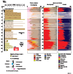
Appendix 1.1: WC 2
Appendix 1.2: Wertaloona 1
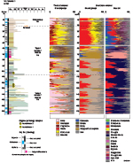
Appendix 1.2: Wertaloona 1
Appendix 1.3: Wooltana 1

Appendix 1.3: Wooltana 1
Appendix 2: Methodology for GC-MS
Gas chromatography-mass spectrometry (GC-MS) was undertaken on a sample of black shale (oil shale) from drill core in Wooltana 1 (143.43–243.48 m, SA Geodata rock sample 1791199) and a cuttings sample of lignite from A 10 (255–260 ft, 1830285). This investigation employed laboratory techniques routinely used in the petroleum services industry to geochemically analyse oil and extractable organic matter. Analyses were undertaken by Geotechnical Services Pty Ltd (Welshpool, Western Australia), a member of the Intertek group of companies.
The samples were finely crushed and extracted with CH2Cl2 using sonic vibration. After filtration, a small quantity of MgSO4 was added to the extract to remove any water. The extract was then filtered and passed through activated Cu powder to remove elemental sulfur. Extractable organic matter (EOM) was collected by evaporation of the solvent by fractional distillation. The extracts and their derivative fractions were analysed using various GC-MS techniques, as described below.
Whole extracts were analysed in scan mode producing a chromatogram of the compounds present from C9 to C36. These analyses were performed using a Hewlett-Packard 5890 Series II GC/5971 MSD, a ZB-1 capillary column (30 m x 0.25 mm i.d.; 0.25 µm film thickness) in split mode, and helium as the carrier gas. The oven temperature was held at 60 °C for 1 minute and then increased at 5° per minute to 300 °C where it was held for 13 minutes.
Sub-samples of the whole-extracts were separated into fractions comprising saturated hydrocarbons, aromatic hydrocarbons and NSO (nitrogen, sulfur and oxygen)-bearing polar compounds. This was achieved by liquid column chromatography using activated silica gel as the adsorbent, and by eluting solvents of varying and sequentially increasing polarity (pentane, pentane/dichloromethane and then dichloromethane/methanol). The saturated hydrocarbon, aromatic hydrocarbon and polar fractions were recovered by evaporation of the solvent by fractional distillation. The saturated hydrocarbon fraction was treated with ZSM-5 to isolate the branched/cyclic compounds. Analysis of both the total saturated hydrocarbon fraction and the branched/cyclic fraction (naphthenic hydrocarbons) was carried out using selective ion monitoring (SIM) with identical instrumentation and conditions described above; however, the column’s length was 60 m, and the samples were injected in pulsed-splitless mode. In this case the temperature of the oven was held at 70 °C for 1 minute, where after the temperature was raised to 270 °C at 8° per minute, then to 285 °C at 1° per minute, and held at that temperature for 49 minutes.
Appendix 3: Stratigraphic summary
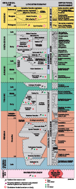
Appendix 3: Stratigraphic summary
Acknowledgements
Lloyd Sampson (Department of Environment Water and Natural Resources, DEWNR, South Australia) kindly provided the most up-to-date potentiometric surface of the GAB. HyLogger data acquisition and processing were undertaken by Alan Mauger and Georgina Gordon. Paul Magarey, formerly with DEWNR, assisted with Table 4. This paper benefitted from reviews by Tony Hill (Energy Resources Division, Department of State Development), Steve Hill (Geological Survey of South Australia, GSSA) and Tony Hall (Sprigg Geobiology Centre, University of Adelaide).
The contribution of David McKirdy to this paper comprises TRaX Record 355. Previously unpublished data, ideas and conclusions expressed in this paper were derived from research undertaken since January 2010 exclusively while Bernd Michaelsen was an employee of the GSSA.
References
Alley NF 1998. Cainozoic stratigraphy, palaeoenvironments and geological evolution of the Lake Eyre Basin. Palaeogeography, Palaeoclimatology, Palaeoecology 144:239–263.
Arouri KR and McKirdy DM 2005. The behaviour of aromatic hydrocarbons in artificial mixtures of Permian and Jurassic end-member oils: application to in-reservoir mixing in the Eromanga Basin, Australia. Organic Geochemistry 36:105–115.
Arouri KR, McKirdy DM, Schwark L, Leythaeuser D and Boult PJ 2004. Accumulation and mixing of hydrocarbons in oil fields along the Murteree Ridge, Eromanga Basin, South Australia. Organic Geochemistry 35:1597–1618.
Brugger J, Long N, McPhail DC and Plimer I 2005. An active amagmatic hydrothermal system: the Paralana hot springs, Northern Flinders Ranges, South Australia. Chemical Geology 222:35–64.
Callen RA 1977. Late Cainozoic environs of part of northeastern South Australia. Journal of the Geological Society of Australia 24:151–169.
Callen RA and Tedford RH 1976. New late Cainozoic rock units and depositional environments, Lake Frome area, South Australia. Transactions of the Royal Society of South Australia 100:125–167.
Cohen KM, Finney SC, Gibbard PL and Fan J-X 2013. The ICS International Chronostratigraphic Chart. Episodes 36:199–204.
Cook AC 1986. The nature and significance of organic facies in the Eromanga Basin. In DI Gravestock, PS Moore and GM Pitt eds, Contributions to the geology and hydrocarbon potential of the Eromanga Basin, Special Publication 12. Geological Society of Australia, pp. 203–219.
Cross AJ, Jaireth S, Hore SB, Michaelsen BH and Schofield A 2010. SHRIMP U-Pb detrital zircon results, Lake Frome region, South Australia, Record 2010/46. Geoscience Australia, Canberra.
Curtis JL, Brunt DA and Binks PJ 1990. Tertiary palaeochannel uranium deposits of South Australia. In FE Hughes ed., Geology of the mineral deposits of Australia and Papua New Guinea, Monograph Series 14. Australasian Institute of Mining and Metallurgy, pp. 1631–1636.
Espitalié J, Senga Makadi K and Trichet J 1984. Role of mineral matrix during kerogen pyrolysis. Organic Geochemistry 6:365–382.
Habermehl MA 1986. Regional groundwater movement, hydrochemistry and hydrocarbon migration in the Eromanga Basin. In DI Gravestock, PS Moore and GM Pitt eds, Contributions to the geology and hydrocarbon potential of the Eromanga Basin, Special Publication 12. Geological Society of Australia, pp. 353–376.
Heathgate Resources 1998. Beverley uranium mine: environmental impact statement: main report. Heathgate Resources, Adelaide.
Hore S 2008. Mount Painter region: uranium mineralising systems and a new regional exploration approach. South Australian Resources and Energy Investment Conference 2008, oral presentation. Primary Industries and Resources South Australia, Adelaide.
Hutton AC, Kantsler AJ, Cook AC and McKirdy DM 1980. Organic matter in oil shales. APEA Journal 20(1):44–67.
Italiano F, Yuce G, Uysal IT, Gasparon M and Morelli G 2014. Insights into mantle-type volatiles contribution from dissolved gases in artesian waters of the Great Artesian Basin, Australia. Chemical Geology 378–379:75–88.
Jaireth S, McKay A and Lambert I 2008. Association of large sandstone uranium deposits with hydrocarbons. AusGeo News 89.
Jones RW and Demaison GJ 1980. Organic facies – stratigraphic concept and exploration tool. American Association of Petroleum Geologists Bulletin 64:729.
Landais P 1996. Organic geochemistry of sedimentary uranium ore deposits. Organic Geochemistry 11:33–51.
Langford FF and Blanc-Valleron M-M 1990. Interpreting Rock-Eval pyrolysis data using graphs of pyrolizable hydrocarbons vs. total organic carbon. American Association of Petroleum Geologists Bulletin 70:799–804.
Marsland-Smith A, Huddleston A, Packer B and Smith A 2011. Uranium exploration and recently discovered uranium deposits in the Frome Embayment, South Australia. 2011 Sprigg Symposium, Abstracts 100. Geological Society of Australia, pp. 43–46.
Martin HA 1990. The palynology of the Namba Formation in Wooltana-1 bore, Callabonna Basin (Lake Frome), South Australia, and its relevance to Miocene grasslands in central Australia. Alcheringa 14:247–255.
Mawson D 1927. The Paralana Hot Spring. Transactions of the Royal Society of South Australia 20:391–397.
McKirdy DM and Chivas AR 1992. Nonbiodegraded aromatic condensate associated with volcanic supercritical carbon dioxide, Otway Basin: implications for primary migration from terrestrial organic matter. Organic Geochemistry 18(5):611–627.
McKirdy DM, Emmett JK, Mooney BA, Cox RE and Watson BL 1986. Organic geochemical facies of the Cretaceous Bulldog Shale, western Eromanga Basin, South Australia. In DI Gravestock, PS Moore and GM Pitt eds, Contributions to the geology and hydrocarbon potential of the Eromanga Basin, Special Publication 12. Geological Society of Australia, pp. 287–304.
McLaren S, Sandiford M, Hand M, Neumann N, Wyborn L and Bastrakova I 2003. The hot southern continent: heat flow and heat production in Australian Proterozoic terranes. In RR Hillis and D Muller eds, Evolution and dynamics of the Australian Plate, Special Publication 22. Geological Society of Australia, pp. 151–161.
Michaelsen BH 1986. Organic facies and petroleum-generative potential of the Murta Member (Mooga Formation), in the Eromanga Basin, South Australia. BSc(Hons) thesis, University of Adelaide.
Michaelsen BH 2002. Geochemical perspectives on the petroleum habitat of the Cooper and Eromanga basins, central Australia. PhD thesis, University of Adelaide.
Michaelsen BH and Fabris AJ 2011. Organic facies of the Frome Embayment and Callabonna Sub-basin: what are the uranium reductants? 2011 Sprigg Symposium, Abstracts 100. Geological Society of Australia, pp. 49–52.
Michaelsen BH and Fabris AJ 2014. Organic facies of the Frome Embayment and Callabonna Sub-basin – what and where the uranium reductants? The AusIMM International Uranium Conference 2014, Program/Abstracts. Australasian Institute of Mining and Metallurgy, pp. 63–64.
Michaelsen BH, Keeling JL, Fabris AJ, Katona LF, Tucker LR and Mauger AJ 2016. HyLogger™ mapping of fluid flux in the Poontana Trough, Callabonna Sub-basin – Implications for exploration of sandstone-hosted uranium. AusIMM International Uranium Conference 2016, Program/Abstracts. Australasian Institute of Mining and Metallurgy, pp. 45–48.
Michaelsen BH and McKirdy DM 1989. Organic facies and petroleum generative-potential of the lacustrine Murta Member (Mooga Formation) in the Eromanga Basin, Australia. In B O’Neil ed., The Cooper and Eromanga basins, Australia, Proceedings of the Cooper and Eromanga Basins Conference. Petroleum Exploration Society of Australia, Society of Petroleum Engineers, Australian Society of Exploration Geophysicists (SA Branches), Adelaide, pp. 541–558.
Michaelsen BM and McKirdy DM 2001. Migration and mixing of oils in the Cooper and Eromanga basins, central Australia. In KC Hill and T Bernecker eds, Eastern Australasian Basins Symposium, Special Publication. Petroleum Exploration Society of Australia, Carlton, pp. 289–300.
Nakashima S, Disnar JR, Perchot A and Trichet J 1984. Experimental study of mechanisms of fixation and reduction of uranium by sedimentary organic matter under diagenetic or hydrothermal conditions. Geochimica et Cosmochimica Acta 48:2321–2329.
Neumann NL, Sandiford M and Foden J 2000. Regional geochemistry and continental heat flow: implications for the origin of the South Australian heat flow anomaly. Earth and Planetary Science Letters 83:107–120.
Peters KE 1986. Guidelines for evaluating petroleum source rock using programmed pyrolysis. American Association of Petroleum Geologists Bulletin 70:318–330.
Powell TG 1986. Petroleum geochemistry and depositional setting of lacustrine source rocks. Marine and Petroleum Geology 3:31–42.
Powell TG 1987. Depositional controls on source rock character and crude oil composition. Proceedings of the 12th World Petroleum Congress, Volume 2. Wiley, pp. 31–42.
Powell TG, Boreham CJ, McKirdy DM, Michaelsen BH and Summons RE 1989. Petroleum geochemistry of the Murta Member, Mooga Formation, and associated oils, Eromanga Basin, Australia. Australian Petroleum Exploration Association Journal 29(1):114–129.
Quigley M, Sandiford M, Alimanovic A and Fifield LK 2007. Landscape responses to intraplate deformation in the Flinders Ranges, South Australia: quantitative constraints from 10Be abundances. Earth and Planetary Science Letters 261:120–133.
Shen Z, Zhou G, Li H, Miao D and Li P 1996. Supercritical carbon dioxide extraction of organic matter from petroleum source rocks and its implications. Chinese Journal of Geology 15:324–330.
Spirakis CS 1996. The roles of organic matter in the formation of uranium deposits in sedimentary rocks. Ore Geology Reviews 11:53–69.
Stach E, Mackowsky M-T, Teichmueller M, Taylor GH, Chandra D and Teichmueller R eds 1982. Stach’s textbook of coal petrology. 3rd edn. Gebrüder Borntraeger, Berlin.
Standards Australia 1989. Coal petrography, Part 2: maceral analysis, Australian Standard AS 2486.2-1989. 2nd edn. Standards Association of Australia, Sydney.
Thiel S, Peacock J, Soeffky P and Heinson G 2012. Fault-controlled uranium emplacement imaged using magnetotellurics, poster. 21st Meeting of the International Association of Geomagnetism and Aeronomy (International Union of Geodesy and Geophysics), Workshop Group 1.2: Workshop on electromagnetic induction in the earth, August 25–31, 2012, Darwin.
Thiel S, Soeffky, Krieger L, Regenauer-Lieb K, Peacock J and Heinson G 2016. Conductivity response to intraplate deformation: evidence for metamorphic devolatization and crustal-scale fluid focusing. Geophysical Research Letters.
Tissot BP and Welte DH 1984. Petroleum formation and occurrence. 2nd edn. Springer-Verlag, Berlin.
Unsworth M and Rondenay S 2012. Mapping the distribution of fluids in the crust and lithospheric mantle utilising geophysical methods. In DE Harlov and H Austrheim eds, Metasomatism and the Chemical Transformation of Rock, Lecture Notes in the Earth System Sciences, Springer-Verlag, Berlin, pp. 535–598.
Wülser P-A, Brugger J, Foden J and Pfeifer H-R 2011. The sandstone-hosted Beverley uranium deposit, Lake Frome Basin, South Australia: mineralogy, geochemistry, and a time-constrained model for its genesis. Economic Geology 106:835–867.
Zoellner E 1988. Geology of the Early Cretaceous Murta Member (Mooga Formation) in the Cooper Basin area, South Australia and Queensland. PhD thesis, Flinders University, Adelaide.