
Geophysical cover characterisation
A key component of improving mineral exploration under cover is to improve mapping of the thickness and character of cover through geophysical imaging and prediction into data sparse areas. In order to test cost-effective cover-thickness determinations, GA and GSSA trialled passive seismic, reflection seismic, magnetotelluric (MT) and micro-gravity methods over the Nullarbor Plain. The objective of the Geophysical Cover Characterisation project was to assess the technical capability of these techniques to map cover-thickness over the Eucla region, particularly in areas of deep cover and karstic limestones, and to assess the micro-gravity technique to image large cavities within the karst.
Magnetotelluric data in the Far West
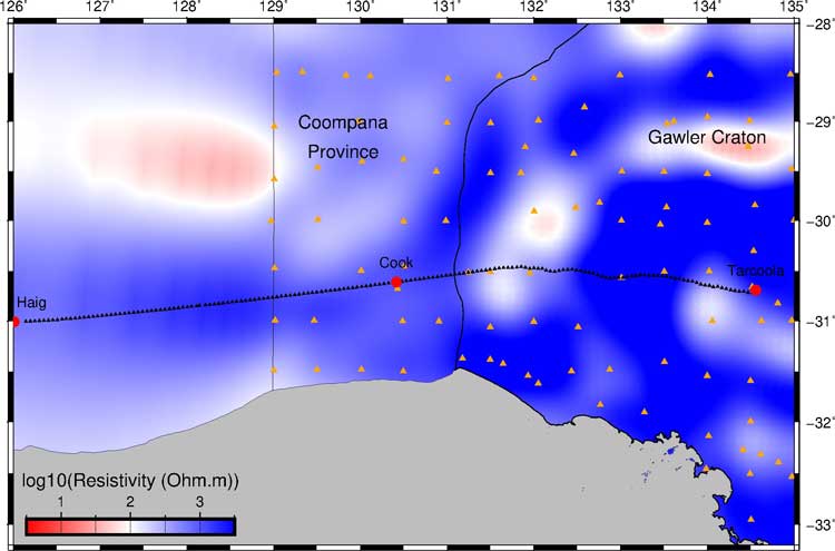
Resistivity model of AusLAMP MT data modelled using ModEM3DMT (orange triangles; note no AusLAMP data in the part of WA on the map). Eucla-Gawler MT sites are shown by black triangles. The profile was modelled in two sections- Haig to Cook, and Cook to Tarcoola.
The Eucla-Gawler broadband magnetotelluric (MT) transect follows the traverse of the Eucla-Gawler seismic survey (13GA-EG1). A total of 167 MT sites with 5km site spacing were collected along an 840 km profile with a processed period range of 0.025-2000s. The survey was a collaborative project between Geoscience Australia, the Geological Survey of Southern Australia, and the Geological Survey of Western Australia. Due to the length of the survey line, the data have been modelled in two sections. This first section of the line covered the western Gawler Craton, covering ~360 km from near Cook to Tarcoola in the central Gawler Craton. The data from both segments are available for download as EDI files along with the below images of the inversions. The western model extends ~500 km from MT station EGC1 in Haig, Western Australia to MT station EGC100 at Cook, South Australia. The eastern model begins at EGC90 and extends east to the end of the line at EGC167, Tarcoola, South Australia.
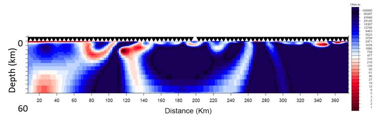
2D inversion of broadband MT data using WinGLink software of the Albany Fraser AF3 profile and western MT sites of the Eucla-Gawler profile EGC1 (near Haig, WA) to the site ECG100 (Cook, SA).
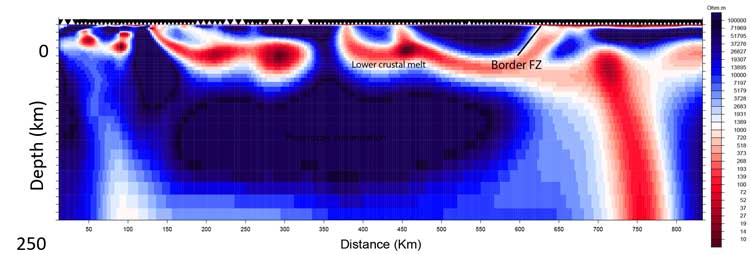
2D inversion of broadband MT data using WinGLink software of the eastern MT sites EGC90 (near Cook, SA) to the eastern extent of the profile at site EGC167 (Tarcoola, SA).
In addition to the 5 km spaced broadband MT transect, there are also AusLAMP data available through SARIG. These data are long period (~10-10 000s) MT data across a 55 km spaced grid in collaboration with Geoscience Australia and the University of Adelaide.
MT Releases from program partners
- Cover Thickness Estimates in the Coompana Province, South Australia: Benchmarking and results from the pre-drilling geophysics program – Magnetotellurics (Geoscience Australia)
- Pre-drilling geophysics in the Coompana Province of South Australia: Benchmarking magnetotelluric and active seismic cover thickness estimates against preliminary drilling results (Geoscience Australia)
- Geological interpretation of the Madura and Coompana Provinces along the Eucla--Gawler seismic and magnetotelluric line 13GA-EG1 (Geological Survey WA)
PACE Copper Coompana Gravity Survey
The PACE Copper Coompana Gravity Survey comprises over 13,000 new gravity observations in the state’s far west. The area is largely underexplored and these data provide new insight into the underlying geology, with implications not only for the exploration community both locally and throughout South Australia, but also the economy of South Australia. The Coompana area is prospective for gold, nickel and copper.
The PACE Copper Coompana Gravity Survey dataset (survey code 2017A1) is available for download via the South Australian Resources Information Gateway (SARIG)
Coompana magnetic and radiometric survey
The largest airborne magnetic and radiometric survey ever conducted in South Australia was completed in late 2015. The survey covers the Coompana Province and parts of the Officer, Eucla and Bight basins, representing under-explored frontier areas in the state's far west.
The survey collected over 250,000 line kilometres of pre-competitive geophysical data at 400m line spacing, with 200m infill over the Coompana Anomaly, at 60m flight height.
The Coompana magnetic and radiometric datasets (survey code 2015SA001) are available for download via SARIG.
Eucla-Gawler seismic survey (13GA-EG1)
The western Gawler Craton and basement to the Eucla Basin are some of the last truly underexplored green-field terrains in South Australia. Located under shallow to thick cover adjacent to the Southern boundary of the Woomera Prohibited Area, the regions present a significant opportunity to open up new ground for exploration in the state and to probe methods for exploring through cover.
New deep crustal seismic section (13GA-EG1), together with new gravity and magnetotelluric data, has been captured from Tarcoola in South Australia to Haig in Western Australia. These 834 kilometres of continuous data will help open up new opportunities for explorers in South Australia and stimulate mineral exploration investment in the states underexplored west.
The survey is a collaborative project between the Geological Survey of South Australia, the Geological Survey of Western Australia, Geoscience Australia and AuScope Earth Imaging, with funding in South Australia provided through the PACE initiative.
Due to the length of the survey line, the data has been processed and released in a number of batches. This first section of the line covered the western Gawler Craton, covering ~360 km from near Cook to Tarcoola in the central Gawler Craton. The data for this segment (13GA-EG1E) is available to download in SEGY format (unmigrated field stacks and migrated data). Also available are the results of collaborative interpretations of the seismic and magnetotelluric data presented in an extended abstract volume (Report Book 2015/00029).
The remainder of the seismic and magnetotelluric line, including the Coompana Province and Madura Province, has been processed and was released at the Australian Earth Sciences Convention (AESC) in June 2016.