Mark Pawley, Tom Wise, Rian Dutch and Liz Jagodzinski
Geological Survey of South Australia, Department for Energy and Mining
Download this article as a PDF (6 MB); cite as MESA Journal 93, pages 4–23
Published October 2020
Contents
Introduction
Geology of the eastern Coompana Province
Proposed stratigraphic scheme for the eastern Coompana Province
New unit within the Toolgana Supersuite, c. 1622–1591 Ma
New unit, unassigned supersuite, c. 1526 Ma
New unit within the Undawidgi Supersuite, c. 1500 Ma
New units within the Moodini Supersuite, c. 1190–1140 Ma
New units within the Warakurna Supersuite, c. 1075 Ma
Summary of type localities from the Coompana Province
References
Introduction
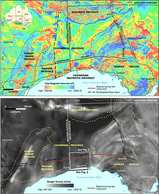
The Coompana Province represents ~200,000 km2 of crystalline basement that is located between the Gawler Craton to the east, Musgrave Province to the north and Madura Province to the west (Fig 1). As this region occurs between the West Australian, South Australian and North Australian cratons, the Coompana Province is also crucial to understanding the Proterozoic evolution of Australia. However, the province is completely buried beneath Neoproterozoic to Phanerozoic sediments of the Officer, Denman, Bight and Eucla basins.
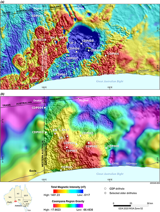
Prior to 2013, our knowledge of the Coompana Province has come from geophysical datasets and a small number of basement intersecting drillholes providing physical samples (Fig 2). Several exploration diamond drillholes targeting remnantly magnetised bodies, including BN 1, BN 2, CD 1 and KN 1, intersected mafic rocks in the southwest corner of South Australia (Carpentaria Exploration Co. Pty Ltd 1982; Shell Company of Australia 1983). A number of drillholes targeting petroleum returned diamond core and chip samples, including Mallabie 1 in the southeast (Outback Oil Company NL 1969), Eucla 1 in the southwest (in Western Australia; Kirkland et al. 2011), and Kutjara 1 and Mulyawara 1 in the north of the Coompana Province (Baily et al. 2012a, 2012b). Furthermore, water bores that were drilled in the 1890s using cable tool, including Albala-Karoo and Guinewarra bores, produced chip samples. Samples from these drillholes have been variably analysed for geochronology, whole-rock geochemistry, and isotopic compositions (e.g. Neumann and Korsch 2014; Wade et al. 2007).
The first drilling program focused on understanding the geological history of the Coompana Province was undertaken in the western part of the province by the Geological Survey of Western Australia in 2013 (Spaggiari and Smithies 2015). This work recognised a series of rock-forming events that were placed within a three-stage geological history. This involved: (1) arc magmatism represented by the c. 1610 Ma Toolgana Supersuite; (2) lithospheric extension represented by the c. 1500 Ma Undawidgi Supersuite; and (3) c. 1192–1150 Ma extension and partial melting of the crust to produce the Moodini Supersuite (Kirkland et al. 2015, 2017; Smithies et al. 2015; Spaggiari et al. 2015b; Wingate et al. 2015a).
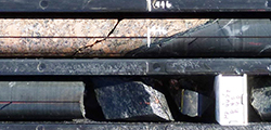
A drilling campaign undertaken by the Geological Survey of South Australia in southwest South Australia in 2017 provided the first drill core samples across a large area of the eastern Coompana Province (Figs 2, 3; Dutch et al. 2018). As a result, these samples allowed the work started in Western Australia to be expanded, significantly increasing our understanding of the architecture and geological evolution of the eastern Coompana Province. These findings are being released as a series of Geological Survey publications, conference presentations and forthcoming journal articles. To complement these publications, this article presents a list and detailed definitions of the new formal stratigraphic units that make up the eastern Coompana Province.
Geology of the eastern Coompana Province
The evolution of the basement of the eastern Coompana Province can be divided into two main geodynamic events (Wise et al. 2018). These events are summarised in this section, and for more detail, the reader is referred to Dutch et al. (2018) and Wise et al. (2018).
1 Prolonged arc–subduction cycles
Several cycles of subduction and arc magmatism, which are interpreted to have consumed an oceanic crust dating back to c. 2000–1900 Ma (Hartnady et al. 2018; Kirkland et al. 2017), can be recognised in the Coompana Province. The oldest dated rocks are the c. 1618 Ma migmatitic orthogneisses of the Koomalboogurra Suite (new unit), of the Toolgana Supersuite (Dutch 2018; Jagodzinski and Bodorkos 2018; Wingate et al. 2015a). These rocks are similar in age and composition to the St Peter Suite in the southern Gawler Craton, and are interpreted to represent subduction-related granites that developed on the edge, or outboard of the Gawler Craton (Dutch et al. 2016; Swain et al. 2008). The c. 1526 Ma migmatitic orthogneisses of the Bunburra Suite (new unit) represent a newly recognised magmatic event in the region (Dutch 2018; Jagodzinski et al. 2019). These rocks have juvenile isotopic character and primitive geochemical signatures, indicating the Bunburra Suite was derived from a subduction-enriched lithospheric mantle source (Dutch 2018).
The c. 1505 Ma Gilgerabbie Suite (new unit) in the eastern Coompana Province (Wade et al. 2007) is considered to be part of the c. 1505–1487 Ma A type Undawidgi Supersuite that was recognised in the western Coompana Province (Wingate et al. 2015a). These rocks are interpreted to be the product of intracontinental extension (Smithies et al. 2015) following cessation of c. 1526 Ma subduction.
2 Intracontinental meltdown
At c. 1200–1070 Ma, the Coompana Province underwent two stages of intraplate magmatism that resulted in two compositionally distinct magmatic suites, the mafic–intermediate Merdayerrah Shoshonite and felsic Koonalda Suite, and the mafic Giants Head and Warbla suites (new units; Dutch et al. 2018; Jagodzinski et al. 2019; Wise et al. 2018). The details of these units and their components will be described in this article.
The relatively juvenile ɛHf1174–1140 Ma values of the Merdayerrah Shoshonite and Koonalda Suite melts suggest little or no assimilation of any pre-1900 Ma crust, and they appear to be the product of mantle input and assimilation of crust similar to the Bunburra and Koomalboogurra suites (Dutch 2018).
Mantle melting at c. 1074 Ma produced the mafic rocks of the Giants Head and Warbla suites, which have distinctive compositions that suggest derivation from heterogeneous lithospheric mantle (see below; Dutch 2018). The rocks also show evolved (strongly negative) ɛHf1074 Ma values, indicating that contamination by a >1900 Ma crust is required (Dutch 2018). A highly reflective lower crustal unit in the seismic section, coincident with the top of a subvertical mantle conductor, is interpreted to be an extension of the older Gawler Craton crust beneath the Coompana Province (Pawley et al. 2018a; Wise et al. 2018), and contaminated the ascending mantle melts.
Proposed stratigraphic scheme for the eastern Coompana Province
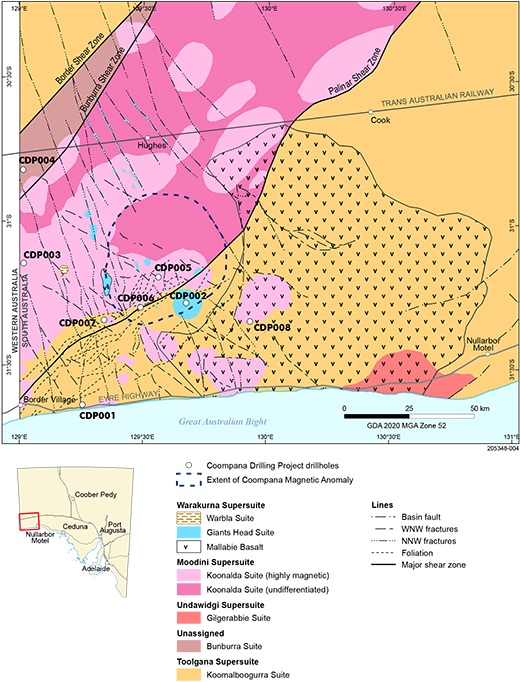
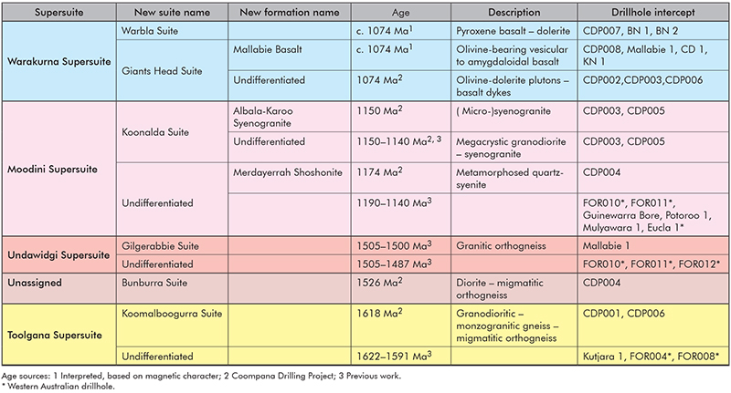
A sequence for the basement rocks of the Coompana Province has been proposed, comprising nine new formal stratigraphic units (Fig 4). In most cases, the new units can be related to the stratigraphic units recognised in the western Coompana Province (Spaggiari and Smithies 2015) and these have been used as parent units where appropriate:
- The c. 1618 Ma Koomalboogurra Suite, which comprises subduction-related granitic rocks that were partially melted at c. 1163 Ma, is included in the Toolgana Supersuite.
- The c. 1526 Ma Bunburra Suite is a newly recognised unit, which includes migmatitic rocks that were deformed and partially melted at c. 1197 Ma (Jagodzinski et al. 2019).
- The c. 1505 Ma Gilgerabbie Suite comprises intrusive rocks that were generated during intracontinental extension and is included in the Undawidgi Supersuite (Smithies et al. 2015; Wade et al. 2007; Wingate et al. 2015a).
- The c. 1174 Ma Merdayerrah Shoshonite and c. 1150–1140 Ma Koonalda Suite, which includes the Albala-Karoo Syenogranite, represent high-grade metamorphism, anatexis, deformation and magmatism (Dutch et al. 2018; Jagodzinski et al. 2019), and are included in the 1192–1141 Ma Moodini Supersuite (Wingate et al. 2015a). The Moodini Supersuite is part of a broader tectonomagmatic event between the West, South and North Australian cratons, affecting the Musgrave Province to the north, and the Madura Province and Albany–Fraser Orogen to the west (Clark et al. 2000; Jagodzinski and Dutch 2013; Smithies et al. 2011; Wingate et al. 2015b; Spaggiari et al. 2016).
- The c. 1074 Ma magmatic event produced three new formal units. The Giants Head Suite includes olivine-bearing rocks that are split into ‘undifferentiated’ Giants Head Suite, which includes the doleritic-gabbroic rocks that form plutons and basalt sheets, and the Mallabie Basalt that comprises vesicular olivine-bearing basalt. The pyroxene-bearing rocks form subvolcanic intrusions and extrusive rocks that are assigned to the Warbla Suite. As well as different mineralogy, these two suites also have distinctive geochemical compositions that suggest they are not genetically related and had different sources (Dutch 2018). The Giants Head Suite was derived from a source that included unradiogenic older crustal material not seen in other Coompana Province rocks, whereas the Warbla Suite was derived from the same modified lithospheric mantle source that produced the Merdayerrah Shoshonite (Dutch 2018). Despite these differences, the two suites have similar timing relations and share the same remnant magnetic signature (e.g. Foss et al. 2018), suggesting they were contemporaneous and should be considered part of the same supersuite (Dutch 2018). The Giants Head and Warbla suites represent a mafic magmatic event in the southeastern Coompana Province that can be temporally correlated with the Warakurna Supersuite and extends the originally proposed Warakurna Large Igneous Province (Howard et al. 2011, 2006a; Wingate et al. 2004) to the south by over 400 km.
New unit within the Toolgana Supersuite, c. 1622–1591 Ma
Definition of the Koomalboogurra Suite
Name
From Koomalboogurra Cave (located at GDA94, zone 52, 556164 mE, 6517210 mN), which is ~36 km to the northeast of drillhole CDP001.
Parent unit
The Koomalboogurra Suite is part of the Toolgana Supersuite (Smithies et al. 2015; Wingate et al. 2015a).
Lithology
The Koomalboogurra Suite comprises migmatitic rocks that range in composition from granodioritic to monzogranitic. They vary from uniformly layered orthogneisses (plastically deformed stromatic metatexites) with regular bands of the mafic and leucocratic components, to more heterogeneous gneisses where the layering is less well preserved (Fig 5). The contacts between the two types are transitional and difficult to precisely define.
The well-layered orthogneisses have leucocratic layers and augen, defined by recrystallised feldspar and recrystallised aggregates of feldspar and quartz, which are separated by a melanocratic groundmass comprising fine-grained mafic minerals (biotite, hornblende and minor magnetite; Fig 5a). The more heterogeneous rocks form a spectrum between compositional and textural end-members. The mafic-rich end-member has isolated leucocratic lenses and layers of feldspar and quartz in a melanocratic groundmass of aligned mafic minerals (i.e. biotite, hornblende and garnet with minor magnetite). The felsic-rich end-member has remnants of the gneiss and mafic schlieren in a feldspar- and quartz-dominated groundmass (locally forming a diatexite). This groundmass appears granitic and is coarse- to medium-grained, relatively equigranular and massive, and often grades into leucocratic anatectic granite. The felsic component can contain rare garnet, indicating that the melt was peraluminous (Mason 2018).
The migmatitic layering is generally shallowly dipping and locally folded into tight to isoclinal recumbent folds (Fig 5b; Pawley et al. under review). The rocks of the Koomalboogurra Suite have experienced varying degrees of selective alteration (Fig 5c; Mason 2018). The plagioclase has been replaced by albite–sericite–zoisite–hematite, K-feldspar by hematite, and the mafic minerals by chlorite and minor zoisite. Primary magnetite was partially replaced by hematite. Prehnite is less common, locally occurring in altered plagioclase and biotite. The rocks in CDP006, which is located in the trace of the Palinar Shear Zone, are extensively altered, suggesting that this structure focused alteration fluids. The rocks in CDP006 are also cut by quartz veins that can contain chlorite, hematite and trace sulfides.
Figure 5 Core photographs of the Koomalboogurra Suite. (Field of view is ~15 cm wide)
5(a) Metatexite from CDP001 (554 m) with smaller than centimetre-scale leucosome layers and lenses separated by thin melanosomes. There are scattered wider leucosomes that locally transgress the layering. (Photo 418135)
5(b) Metatexite from CDP001 (531.5 m) with folded migmatitic layering. There are wider leucosomes that locally transgress the layering. (Photo 418136)
5(c) Metatexite from CDP006 (384.15–386.06 m) with the migmatitic layering enhanced by selective hematitic alteration. (Photo 418137)
Age
The age of the Koomalboogurra Suite is constrained by SHRIMP U–Pb age dates of samples from two drill cores (Jagodzinski et al. 2019). An orthogneiss from CDP001 (SA Geodata rock sample 2427076 from depth interval 499.35–500.65 m) was dated at 1618 ± 6 Ma. A migmatitic gneiss from CDP006 (sample 2425443 from depth interval 384.15–386.06 m) was dated at 1618 ± 9 Ma. These dates are interpreted to be the age of the igneous protolith. Sample 2425443 also had an age population at 1163 ± 8 Ma that was interpreted to be the timing of high-grade metamorphism and anatexis (Jagodzinski et al. 2019).
Distribution
The Koomalboogurra Suite is not exposed and has been recognised in drill core from two holes – CDP001 and CDP006 – where the migmatitic gneisses form the dominant lithology (Dutch et al. 2017b; Dutch et al. 2017c; Pawley et al. 2018b). Basement gneisses from Albala-Karoo Bore, located ~20 km to the south-southeast of CDP006, have been assigned to the Koomalboogurra Suite, despite being undated.
On aeromagnetic images, the Koomalboogurra Suite is characterised by a northeast-trending magnetic layering to the south of the Palinar Shear Zone (Figs 2, 3). The Koomalboogurra Suite can be confidently traced as an eastward-thickening wedge, between the northeast-trending Palinar Shear Zone and the east-trending coast, to east of Albala-Karoo Bore, where it is covered by basaltic lava flows of the Mallabie Basalt (Fig 3; Wise et al. 2018). It is unclear how far the suite continues to the east under the basalt and younger cover rocks, although c. 1158 Ma granite in Guinewarra Bore to the east contains a population of c. 1642 Ma inherited zircons (Fraser and Neumann 2016).
Contact relationships
Based on aeromagnetic images, the northern contact of the Koomalboogurra Suite is interpreted to be sheared along the Palinar Shear Zone, with locally intrusive contacts with granites of the c. 1150 Ma Koonalda Suite (Fig 3). The rocks of the Koomalboogurra Suite are locally intruded by mafic plugs of the c. 1074 Ma Giants Head Suite, and overlain to the east by basaltic lava flows of the Mallabie Basalt, and to the west and north by sandstones of the Officer Basin and Cretaceous Madura Formation.
It is possible the Koomalboogurra Suite occurs north of the Border Shear Zone, in the northeastern Coompana Province. However, this is currently untested.
Type locality
The Koomalboogurra Suite intersected in CDP001 (drillhole number 299055, GDA94, zone 52J, 524279 mE, 6499644 mN, interval 488.53–555.5 m) is proposed as the type section.
New unit, unassigned supersuite, c. 1526 Ma
Definition of the Bunburra Suite
Name
From the Bunburra Rockhole (located at GDA94, zone 52, 515864 mE, 6519983 mN), which is ~63 km to the south of drillhole CDP004.
Parent unit
At this time, the Bunburra Suite is not included as part of a supersuite. There are two reasons why the Bunburra Suite was not included in the Undawidgi Supersuite that was recognised to the west (Smithies et al. 2015; Spaggiari et al. 2015a; Wingate et al. 2015a). First, the Bunburra Suite is ~20 Ma older than the Undawidgi Supersuite. Second, the two units have distinct compositions that suggest they formed in different tectonic settings. Dutch (2018) proposed that the Bunburra Suite was derived from a subduction-enriched lithospheric mantle source in a subduction setting, whereas the younger Undawidgi Supersuite is interpreted to be derived by melting of lower mafic crust with mantle input during lithospheric extension (Smithies et al. 2015; Spaggiari et al. 2015b).
Lithology
The Bunburra Suite comprises migmatitic orthogneisses that are generally dioritic to quartz-dioritic in composition. The mineralogy is dominantly plagioclase and hornblende, with quartz, biotite and K-feldspar as minor phases. The rocks are fine to very coarse grained, and range from grey to black and white speckled, depending on the variation in mineral proportions. Microstructurally, they range from relatively massive to highly plastically deformed.
The rocks of the Bunburra Suite can be classified as schlieren or schollen diatexites, depending on the geometry of the melanosome within the leucocratic component (leucosome) that dominates the rocks (Fig 6). The schlieren are defined by centimetre-wide bands with gradational boundaries that have greater concentration of mafic minerals. The schollen are rafts of medium- to fine-grained melanocratic foliated rock or gneiss, up to 30 cm wide, which represent remnants of the protolith. The schollen are often back-veined by the leucosomes, indicating they are not later intrusive mafic sheets. Both the schlieren and schollen are folded and truncated at a low angle, suggesting magmatic-state deformation and flow.
Locally, the diatexites contain anatectic granites that are coarse- to medium-grained, cream-grey, massive, inequigranular, and contain feldspar, quartz and biotite with common irregular feldspars interpreted to be xenocrysts. These rocks represent the transition from diatexite to granite as the melt-rich diatexite started to flow and homogenise (Pawley et al. 2018b).
Figure 6 Core photographs of the Bunburra Suite from CDP004.
6(a) Diatexite with irregular disaggregated melanosome in a leucocratic groundmass with igneous texture. (Photo 418138)
6(b) Diatexite with folded melanocratic schollen and schlieren in a leucocratic groundmass with igneous texture. (Photo 418139)
Age
The age of the Bunburra Suite is constrained by SHRIMP U–Pb age dates from CDP004 (Jagodzinski et al. 2019). A migmatitic rock from CDP004 was dated at 1526 ± 5 Ma, which was interpreted to be the age of the protolith. An 1197 ± 12 Ma age population was interpreted to be the age of high-grade metamorphism and anatexis (Jagodzinski et al. 2019).
Distribution
The Bunburra Suite is not exposed and has been recognised in drill core from CDP004, where the migmatitic rocks form the dominant lithology (Dutch et al. 2017a; Pawley et al. 2018b). On aeromagnetic images, the Bunburra Suite is characterised by a northeast-trending magnetic layering that occurs in a wedge between the Border and Bunburra shear zones (Fig 3).
Contact relationships
In drill core, the migmatitic rocks of the Bunburra Suite are intruded by sheets of the c. 1174 Ma Merdayerrah Shoshonite that are aligned subparallel to the layering in the host (Fig 7). The aeromagnetic data indicates that the Bunburra Suite has a sheared contact with the Toolgana Supersuite to the northwest (across the Border Shear Zone). The southeastern contact with the Koonalda Suite is generally sheared across the Bunburra Shear Zone, although some of the plutons of the Koonalda Suite intrude across the shear zone and into the Bunburra Suite. The Bunburra Suite is intruded by north-northwest-trending dykes of the Giants Head Suite, and overlain by Neoproterozoic–Cambrian sandstones.
Figure 7 Core photographs of the Merdayerrah Shoshonite from CDP004.
7(a) Foliated texture of the shoshonite. (Field of view is ~15 cm wide; photo 418140)
7(b) Finer grained, dark shoshonite in the lighter coloured diatexite of the Bunburra Suite, and leucosomes injected along the foliation plane. (Photo 418141)
Type locality
The Bunburra Suite intersected in CDP004 (drillhole 299058, GDA 94, zone 52J, 501181 mE, 6589229 mN, interval 491.39–547.18 m.) is proposed as the reference section.
Other
The Bunburra Suite covers a broad silica range, is magnesian, calc-alkalic to alkali-calcic, medium- to high-K with enriched LILE (large ion lithophile elements) and LREE (light rare earth elements) and high LILE/HFSE (high field strength elements) ratios that are typical of a subduction setting. The mafic end-members of the suite are isotopically juvenile with primitive compositions that reflect minimal fractionation and trace enrichments that are unlikely to represent crustal contamination. The Bunburra Suite is interpreted to be subduction-related rocks that are potentially derived from an already subduction-modified enriched lithospheric mantle (Dutch 2018).
New unit within the Undawidgi Supersuite, c. 1500 Ma
Definition of the Gilgerabbie Suite
Name
From the Gilgerabbie Bore (located at GDA94, zone 52, 669800 mE, 6508700 mN), which is ~17.6 km to the east of Mallabie 1 drillhole.
Parent unit
The Gilgerabbie Suite is part of the Undawidgi Supersuite (Smithies et al. 2015; Wingate et al. 2015a).
Lithology
The Gilgerabbie Suite comprises coarse-grained, moderately foliated granitic gneiss. In thin section, the rock has leucocratic zones of granoblastic textured quartz, plagioclase and microcline that alternate with parallel irregular lenses of biotite, hornblende, garnet, titanate and opaque minerals (Fraser and Neumann 2016; Outback Oil Company NL 1969).
Age
The age of the Gilgerabbie Suite is constrained by a SHRIMP U–Pb age date from Mallabie 1, where samples of granitic gneiss were dated at 1505 ± 7 Ma and 1500 ± 8 Ma (Fraser and Neumann 2016; Wade et al. 2007). These are similar to the ages obtained for the Undawidgi Supersuite in the western Coompana Province (Wingate et al. 2015a).
Distribution
The Gilgerabbie Suite is not exposed and has been recognised in drill core from Mallabie 1. On aeromagnetic images, the Gilgerabbie Suite is characterised by a moderately low magnetic response and is interpreted to form an irregular body that can be traced offshore (Figs 2, 3; Wise et al. 2018).
Contact relationships
Based on the aeromagnetic images, the Gilgerabbie Suite appears to intrude the Koomalboogurra Suite (Fig 3). The granitic gneisses are unconformably overlain by 135.3 m of coarse-grained arkosic sandstone with a maximum depositional age of 1151 Ma (Fraser and Neumann 2016; Outback Oil Company NL 1969), which are overlain by lava flows of the c. 1074 Ma Mallabie Basalt.
Type locality
The Gilgerabbie Suite intersected in Mallabie 1 (drillhole 353, GDA94, zone 52, 652185.59 mE, 6509900.04 mN, composite section including two intervals 1404.20–1406.00 m and 1493.50–1495.63 m) is proposed as the type section.
New units within the Moodini Supersuite, c. 1190–1140 Ma
Definition of the Merdayerrah Shoshonite
Name
From the Merdayerrah Sandpatch (located at GDA94, zone 52, 509111 mE, 6496422 mN), which is ~87 km to the south of drillhole CDP004.
Parent unit
The Merdayerrah Shoshonite is not assigned to a suite, but is included in the Moodini Supersuite (Smithies et al. 2015; Wingate et al. 2015a).
Lithology
The Merdayerrah Shoshonite comprises brown to dark green, fine- to medium-grained, granoblastic-textured metamorphosed quartz syenite (Fig 7a), which contains feldspar, hornblende and biotite. The rock generally has a solid-state foliation that is defined by aligned biotite flakes in the equigranular groundmass. The rocks contain rare irregular centimetre-wide feldspar xenocrysts. In places, the meta-quartz syenite also contains common millimetre- to centimetre-scale leucosomes that are thin and parallel to the foliation, or thicker with lobate contacts that are locally transgressive (Fig 7b).
The rock is called a shoshonite, based on the geochemical characteristics of the rock. These include near silica saturation (i.e. ~49–62 wt% SiO2), high total alkalis, high K2O/Na2O ratios, and P2O5, Ba, Sr and LREE enrichment (Dutch 2018; Morrison 1980).
Age
The age of the Merdayerrah Shoshonite is constrained by a SHRIMP U–Pb age date from CDP004, where a sample of meta-quartz syenite was dated at 1174 ± 9 Ma (Jagodzinski et al. 2019).
Distribution
The Merdayerrah Shoshonite has only been recognised in one drillhole in South Australia, CDP004. However, it may be more regionally extensive, as a similar aged unit, the c. 1192–1180 Ma Bottle Corner Shoshonite, has been recognised in the western Coompana Province (Smithies et al. 2015; Spaggiari et al. 2015a; Wingate et al. 2015a).
Contact relationships
The Merdayerrah Shoshonite forms foliated sheets in the diatexites of the Bunburra Suite (Fig 7b) that are aligned subparallel to the migmatitic layering. The sheets often have relatively sharp intrusive contacts, with changes in texture and colour suggesting quenched margins. In places, the meta-quartz syenite also contains thin leucosomes that are parallel to the foliation, and thicker lobate leucosomes that locally transgress the foliation.
Type locality
The Merdayerrah Shoshonite intersected in CDP004 (drillhole 299058, GDA 94, zone 52, 501181 mE, 6589229 mN, interval ~672.5–677.6 m) is proposed as the type section.
Thickness
The Merdayerrah Shoshonite forms sheets that are up to ~5 m wide.
Definition of the Koonalda Suite
Name
From the Koonalda Cave (located at GDA94, zone 52, 579616 mE, 6525155 mN), which is ~35 km to the southeast of drillhole CDP005.
Parent unit
The Koonalda Suite is part of the Moodini Supersuite (Smithies et al. 2015; Wingate et al. 2015a).
Lithology
The granitic rocks of the Koonalda Suite range in composition from syenogranite to granodiorite. The rocks are pink to green in colour, massive, very coarse to fine-grained and porphyritic (locally megacrystic) to inequigranular (Fig 8). They have euhedral–subhedral K-feldspar megacrysts that are up to 5 cm long (Fig 8a). Many phenocrysts display rapakivi textures (Fig 8b), whereas others are concentrically zoned with poikilitic inclusions. Quartz is present as ~5 mm spherical phenocrysts (Fig 8a). The phenocrysts and megacrysts are hosted by a coarse- to fine-grained inequigranular groundmass of plagioclase (now altered to albite), quartz, K-feldspar and biotite. Ovoidal, fine- to medium-grained mafic enclaves are scattered throughout the rock (Fig 8c), and represent cogenetic mingled mafic magmas.
Figure 8 Core photographs of the Koonalda Suite. (Field of view is ~15 cm wide)
8(a) Porphyritic granodiorite from CDP003 (261.2 m) showing the equant, blocky feldspar megacrysts and ovoidal phenocrysts. (Photo 418142)
8(b) Porphyritic granodiorite from CDP005 (478.14 m) showing tabular, subhedral feldspar phenocrysts. (Photo 418143)
8(c) Porphyritic granodiorite from CDP003 (390.52 m) with a mafic enclave. (Photo 418144)
8(d) Contact in CDP003 between the fine-grained Albala-Karoo Syenogranite to the left, and the porphyritic granite to the right (471.33 m). (Photo 418145)
8(e) Albala-Karoo Syenogranite showing the feldspar (cream and elongate) and quartz phenocrysts (grey and equant) in the fine-grained groundmass. (Photo 418146)
Age
Granitic rocks of the Koonalda Suite have been dated in several places, and constrained at c. 1168–1140 Ma. Three ages are from the main area of the Koonalda Suite, and include a sample from CDP003 dated at 1149.96 ± 0.28 Ma using CA-TIMS, and samples from CDP005 and Eucla 1 that were dated using SHRIMP U–Pb at 1147 ± 9 Ma and 1140 ± 8 Ma, respectively (Jagodzinski et al. 2019; Kirkland et al. 2011). A sample of adamellite [sic] from Mulyawara 1 drillhole was dated at 1168 ± 6 Ma (SHRIMP U–Pb; Neumann and Korsch 2014).
Distribution
The Koonalda Suite is not exposed, but can be recognised on aeromagnetic images as a series of prominent magnetically high bodies that correspond to individual plutons (Figs 1, 2). These plutons are generally restricted to a corridor that extends from the coastline near the South Australia – Western Australia border northeast to the northern margin of the Gawler Craton (Fig 1). This corridor is bound by the Palinar Shear Zone to the southeast, and the Border Shear Zone to the northwest (Fig 3).
There are minor plutons outside of the shear-bounded corridor, which have been assigned to the Koonalda Suite on the basis of the aeromagnetic data. These generally occur to the south of the Palinar Shear Zone, although an 1168 ± 6 Ma adamellite [sic] was intersected in drillhole Mulyawara 1 (Neumann and Korsch 2014) to the north of the Border Shear Zone (Figs 2, 3).
Contact relationships
In the corridor between the Palinar and Border shear zones, the Koonalda Suite forms a series of overlapping, elongate elliptical plutons that are generally aligned subparallel to the trend of the corridor. Locally, the plutons intrude across the bounding shear zones, suggesting that deformation was contemporaneous with magma emplacement. Outside the main corridor, the plutons range from elliptical, to irregularly shaped with lobate geometries. The elliptical plutons are aligned subparallel to, but also cut the northeast-trending grain in the aeromagnetic data, suggesting emplacement was contemporaneous with deformation. The plutons are intruded by sheets of the late-stage Albala-Karoo Syenogranite that are up to 4 m wide, and dykes and plugs of the Giants Head Suite. The Koonalda Suite is nonconformably overlain by sandstones of the Lower Cretaceous Loongana Formation to the south, and the Neoproterozoic Officer Basin to the north.
Type locality
The Koonalda Suite intersected in CDP003 (drillhole 299057, GDA94, zone 52J, 502404 mE, 6553601 mN, interval 345.69–411.76 m) is proposed as the type section.
Definition of the Albala-Karoo Syenogranite
Name
From the Albala-Karoo Rockhole (located at GDA94, zone 52, 554857 mE, 6518806 mN), which is ~30 km to the south of drillhole CDP005.
Parent unit
The Albala-Karoo Syenogranite forms part of the Koonalda Suite of the Moodini Supersuite.
Lithology
The Albala-Karoo Syenogranite is pink to brown, massive, fine- to medium-grained and equigranular to locally porphyritic (Fig 8d). It contains millimetre-scale blocky feldspar and equant, euhedral quartz phenocrysts in a groundmass of K-feldspar (often microcline), quartz, plagioclase and biotite (Fig 8e). The syenogranite also contains rare feldspar phenocrysts that are similar to those in the host. These suggest that the syenogranite magma intruded an incompletely crystallised body enabling individual grains to be plucked out of the host.
Age
The Albala-Karoo Syenogranite in CDP003 was dated at 1150.48 ± 0.52 Ma using CA-TIMS (sample 2423466; Jagodzinski et al. 2019). This age suggests that the syenogranite represents a late-stage magma of the Koonalda Suite, and not a later, separate magmatic event.
Distribution
The Albala-Karoo Syenogranite was recognised within CDP003 and CDP005, where it intrudes the coarse-grained porphyritic granites as late-stage magmas. Consequently, it is proposed that the Albala-Karoo Syenogranite likely has the same distribution as the large plutons, which are mostly concentrated within a northeast-trending corridor between the Palinar and Border shear zones, with plutons less abundant outside this corridor.
Contact relationships
The Albala-Karoo Syenogranite forms sheets within the plutons of the Koonalda Suite. The sheets have boundaries that range from sharp and straight, to sharp and irregular with the contact following the grain boundaries in the host granites, to gradational (Fig 8d). The contacts suggest the host was not completely crystalline during intrusion of the syenogranite.
Type locality
The Albala-Karoo Syenogranite intersected in CDP003 (drillhole 299057, GDA94, zone 52 502404 mE, 6553601 mN, interval 265.00–267.80 m) is proposed as a type section.
Thickness
The Albala-Karoo Syenogranite forms sheets that are up to 4 m wide.
New units within the Warakurna Supersuite, c. 1075 Ma
Definition of the Giants Head Suite
Name
From the Giants Head Cave (located at GDA94, zone 52, 571224 mE, 6514740 mN), which is 28.8 km to the south-southeast of drillhole CDP002.
Parent unit
The Giants Head Suite forms part of the c. 1085–1030 Ma Warakurna Supersuite (Howard et al. 2011; Howard et al. 2006b; Quentin de Gromard et al. 2017; Wingate et al. 2004).
Lithology
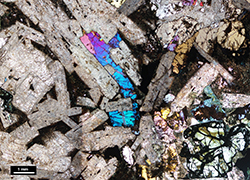
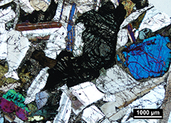
The undifferentiated Giants Head Suite comprises olivine-bearing mafic intrusive rocks, with two texturally distinct phases recognised in the drill core (Fig 9). The dominant phase is a dolerite that is generally dark green to pale grey, fine- to coarse-grained and ranges from inequigranular to porphyritic. The dolerite is characterised by large interlocking plagioclase laths in a fine- to medium-grained groundmass of clinopyroxene, olivine (now replaced by actinolite and opaques), amphibole and fine-grained mesostasis (Figs 9a, c). In places, the dolerite is grey, fine- to medium-grained, massive and equigranular to inequigranular (Fig 9b), characterised by more equant grains with prominent clinopyroxene and olivine (now altered to actinolite and opaque minerals) grains surrounded by plagioclase laths (often sericitised) and mesostasis (Fig 9d; Mason 2018). The texturally different dolerites are interlayered with irregular, gradational contacts, and likely represent textural variation as the mafic intrusive body crystallised and evolved. The dolerite has local pervasive sericite and hematite alteration, and is also locally cut by sets of carbonate veins that are up to 5 mm-thick.
The second phase comprises dark grey, massive, aphyric basalts that form dykes that intrude other rock units (Fig 9e). The basalts have abundant plagioclase laths and chlorite (after the primary ferromagnesian phase), with mesostasis comprising quenched bladed clinopyroxene and magnetite (Mason 2018).
Figure 9 Core photographs and photomicrographs of the undifferentiated plutons of the Giants Head Suite in CDP002.
9(a) Core photograph of the doleritic phase from CDP002 (468.9 m) showing the ophitic texture, with a large patch of fine-grained mesostasis in the lower left of the photograph. (Field of view is ~3 cm wide; photo 418147)
9(b) Core photograph of the more equigranular dolerite from CDP002 (426.9–430.6 m) showing the large blocky olivine surrounded by plagioclase and clinopyroxene (Field of view is ~3 cm wide; photo 418148)
9(c) Photomicrograph of the dolerite from CDP002 (379.1–382.0 m, thin section 2430064A, cross-polarised light), showing the plagioclase laths (now sericite altered) with interstitial clinopyroxene, olivine and mesostasis. (Photo 418149)
9(d) Photomicrograph of the more equigranular dolerite from CPD002 (557.45–558.32 m, thin section 2430074, cross-polarised light), showing the olivine (now altered to actinolite and opaque minerals) and clinopyroxene surrounded by subhedral plagioclase laths. (Photo 418150)
9(e) Core photograph of the basalt of the Giants Head Suite intruding granite of the Koonalda Suite from CPD003 (~446 m). (Photo 418151)
Age
The age of the Giants Head Suite is constrained by a SHRIMP U–Pb age date from CDP002, where a sample of fractionated dolerite was dated at 1074 ± 6 Ma (Jagodzinski et al. 2019).
Distribution
The intrusions of the Giants Head Suite have been intersected in numerous drillholes. They are also remnantly magnetised, and therefore prominent on aeromagnetic images, where they form four main types of intrusion (Figs 1, 2). These features appear to be widespread across the southwestern part of South Australia, and include:
- A series of circular to ovoidal intrusions that are up to 10 km across, but generally less. A larger circular stock was intersected by CDP002 (Fig 2a).
- Massive, aphyric, olivine-bearing basalt sheets that intrude the megacrystic granite in CDP003 (Fig 9e) and migmatitic rocks in CDP006.
- A series of remnantly magnetised sheets that extend to the north-northwest for over 150 km from the area of intrusions described above (Fig 2a). The dykes appear to intrude parallel to a series of faults and joints that are represented on the aeromagnetic images as north-northwest-trending, anastomosing, thin demagnetised zones. None of these dykes have been intersected in drillholes, and are assigned to the Giants Head Suite based on their magnetic character.
- The large (~40 km diameter), circular, remnantly magnetised Coompana Magnetic Anomaly, which is considered part of the Giants Head Suite, despite being untested (Figs 1, 2).
Contact relationships
The Giants Head Suite intrudes rocks of the Koomalboogurra, Bunburra and Koonalda suites with sharp, transgressive contacts (e.g. Fig 9e).
Type locality
The Giants Head Suite intersected in CDP002 (drillhole 299056, GDA94, zone 52J, 564320 mE, 6538745 mN, interval 374.47–445.85 m) is proposed as the type section.
Other
The rocks of the Giants Head Suite have geochemical compositions that suggest they were derived from a source that included unradiogenic older crustal material not sampled by the Warbla Suite (see above; Dutch 2018).
Definition of the Mallabie Basalt
Name
From the Mallabie Tank (located at GDA94, zone 52, 656233 mE, 6517075 mN), which is ~8.2 km to the north-northeast of drillhole Mallabie 1.
Parent unit
The Mallabie Basalt is part of the Giants Head Suite, which forms part of the c. 1085–1030 Ma Warakurna Supersuite (Howard et al. 2011; Howard et al. 2006b; Quentin de Gromard et al. 2017; Wingate et al. 2004).
Lithology
The Mallabie Basalt includes three main extrusive rock types including basalt, brecciated basalt and a volcaniclastic unit.
The basalts are the main rock type in CDP008, and are dark brown-green, massive, fine- to medium-grained and variably vesicular to amygdaloidal (Figs 10a, b). The rocks are generally equigranular with the occasional interval that is porphyritic with common ~5 mm long plagioclase laths (Fig 10b). The amygdales generally occur throughout the flows (not just at the flow tops) and have two main forms (Figs 10a, b): larger (~10 mm) zoned quartz–calcite-filled amygdales; and smaller (~3–10 mm) dark green amygdales that are likely chlorite-filled (Dutch et al. 2017d). Carbonate, sericite and hematite alteration is common throughout the rock. The tops of flows are often strongly hematite–chlorite altered, whereas the cores of flows range from relatively unaltered to weakly chlorite altered.
The brecciated basalts are interpreted to be flow tops and have angular basalt clasts suspended in a very fine grained, hematite-rich, red siltstone matrix (Fig 10c). The basalt fragments have chlorite and hematite alteration (Mason 2018). The brecciated rocks have common carbonate infill and veining (Dutch et al. 2017d).
The volcaniclastic rocks are a minor phase that occur at the top of the Mallabie Basalt in CDP008, directly below the unconformity. These rocks are epiclastic, fine-grained, laminated and dark-red-brown in colour (Dutch et al. 2017d).
Figure 10 Core photographs of the Mallabie Basalt in CDP008. (Field of view is ~15 cm wide)
10(a) Amygdaloidal basalt with vesicles filled by chlorite and carbonate (600.0 m). (Photo 418152)
10(b) Amygdaloidal basalt with chlorite-filled vesicles and feldspar phenocrysts (576.45–577 m). (Photo 418153)
10(c) Brecciated basalt with hematite-altered siltstone filling the gaps (613.3–613.79 m). (Photo 418154)
Age
The Mallabie Basalt has similar geochemistry and the same remnant magnetic signature as the intrusions of the Giants Head Suite (Dutch 2018; Foss et al. 2017), suggesting they are also c. 1074 Ma.
Distribution
The Mallabie Basalt is not exposed, but has been recognised in three drillholes – Mallabie 1, CD 1 and CDP008. The volcanic rocks appear to produce a stippled texture on aeromagnetic images (Fig 2a), which suggests that the unit is preserved in two main areas (Fig 3; Wise et al. 2018). The main body of volcanic rocks occurs in an irregular area with lobate margins that extends westwards from near Mallabie 1 for ~100 km, and northwards from the coast for ~100 km. A smaller area of basalt flows was intersected in CD 1. This area is elliptical, ~10 by 5 km, with the long axis aligned north–south, and coincides with a remnantly magnetised body that may represent a subvolcanic intrusion.
Contact relationships
In Mallabie 1, the Mallabie Basalt overlies a sequence of reddish brown, medium-grained to granular arkosic sandstone (Outback Oil Company NL 1969), with a maximum depositional age of c. 1151 Ma (Fraser and Neumann 2016). The basalts are overlain by an unnamed sequence of sandstone and siltstone that was interpreted as ‘pre-Permian (Cambro-Ordovician?)’. The contacts were not described in the logging report (Outback Oil Company NL 1969). In CD 1, the basalt is interpreted to be unconformably overlain by a sequence of Permian tillite (Shell Company of Australia 1983). In CDP008, the fine grained volcaniclastic unit at the top of the Mallabie Basalt is unconformably overlain by a sequence of sandstones, mudstones and conglomerates.
Type locality
The Mallabie Basalt intersected in CDP008 (drillhole 299062, GDA94, zone 52J, 589323 mE, 6531363 mN, interval 582.80–652.65 m) is proposed as the type section.
Thickness
Mallabie 1 is the only hole to penetrate the volcanic rocks, drilling through 289.56 m of basalt (Outback Oil Company NL 1969). CD 1 penetrated 60 m of basalt without reaching the base of the unit. Logging revealed a series of texturally distinct flows that were up to 20 m thick (Shell Company of Australia 1983). CDP008 drilled ~100 m of basalt without reaching the bottom of the unit. This sequence included a series of lava flows that were 2–20 m thick (Dutch et al. 2017d).
Definition of the Warbla Suite
Name
From the Warbla Cave (located at GDA94, zone 52, 510774 mE, 6512185 mN), which is ~30 km to the southwest of drillhole CDP007.
Parent unit
The Warbla Suite is part of the c. 1085–1030 Ma Warakurna Supersuite (Howard et al. 2011; Howard et al. 2006b; Quentin de Gromard et al. 2017; Wingate et al. 2004).
Lithology
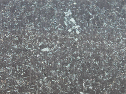
The Warbla Suite comprises pyroxene-bearing (olivine-absent) volcanic to subvolcanic rocks, including dark grey, fine- to medium-grained, massive and inequigranular to weakly porphyritic basalts and dolerites (Fig 11). The rocks contain plagioclase, clinopyroxene and opaque mineral phenocrysts in a groundmass of mesostasis comprising feldspar, clinopyroxene and opaque minerals (Mason 2018). The basalt is homogeneous, but it is locally finer grained and more equigranular.
Figure 11 Core photograph of the porphyritic Warbla Suite in CDP007 (286.0 m) showing the fine feldspar phenocrysts. (Field of view is ~3 cm wide; photo 418155)
Age
The Warbla Suite is undated, but has similar relative timing relations and the same remnant magnetic signature as the c. 1074 Ma Giants Head Suite (Foss et al. 2017) and Mallabie Basalt, and is interpreted to be part of the Warakurna Supersuite.
Distribution
The Warbla Suite is not exposed, but has been recognised in three drillholes – CDP007, BN 1 and BN 2 (Figs 2a, 3). CDP007 corresponds to a small, remnantly magnetic intrusive body that is <1 km long by <0.5 km wide, with the long axis aligned in a north–south orientation. The rocks in BN 1 and BN 2 also correspond to a weakly elongate remnantly magnetised body that is ~2 by 3 km, with the long dimension oriented east-northeast. This observation indicates that it is difficult to confidently assign undrilled remnantly magnetised bodies to either the Giants Head or Warbla suites.
Contact relationships
The remnantly magnetised body intersected in CDP007 intrudes strongly foliated migmatitic rocks of the Koomalboogurra Suite that are characterised by an east-northeast-striking grain on the aeromagnetic images. The body intersected by BN 1 and BN 2 intruded a pluton of the Koonalda Suite.
Type locality
The Warbla Suite intersected in CDP007 (drillhole 299061, GDA 94, zone 52, 532712 mE, 6532306 mN, interval 310.80–351.31 m) is proposed as the type section.
Other
The Warbla Suite is compositionally distinct and does not include the older unradiogenic crustal material sampled by the Giants Head Suite. Instead, the Warbla Suite was derived from the same modified lithospheric mantle source as the Merdayerrah Shoshonite (see above; Dutch 2018).
Summary of type localities from the Coompana Province
The type sections for all of the new units described in this article are all sections of reference drill cores that are stored at the South Australia Drill Core Reference Library, which is located at Tonsley, South Australia. The core is available for viewing, with bookings made via SARIG. The type sections are summarised in Table 1.
Table 1 Type sections for the new stratigraphic units presented in this article
| Stratigraphy | Category | Description | Location | Reference |
|---|---|---|---|---|
| Koomalboogurra Suite | Type drillhole | 66.97 m thick section for which drill core is available | Drillhole CDP001 (299055), 524279 mE, 6499644 mN, 488.53 to 555.5 m | This report |
| Bunburra Suite | Type drillhole | 55.79 m thick section for which drill core is available | Drillhole CDP004 (299058), 501181 mE, 6589229 mN, 491.39 to 547.18 m | This report |
| Gilgerabbie Suite | Type drillhole | 3.95 m thick composite section (two parts) for which drill core is available | Drillhole Mallabie 1 (353), 652185.59 mE, 6509900.04 mN, 1404.20 to 1406.00 m and 1493.50 to 1495.63 m | This report |
| Merdayerrah Shoshonite | Type drillhole | Approximately 5.1 m thick section for which drill core is available | Drillhole CDP004 (299058), 501181 mE, 6589229 mN, approximately 672.5 to 677.6 m | This report |
| Koonalda Suite | Type drillhole | 66.07 m thick section for which drill core is available | Drillhole CDP003 (299057), 502404 mE, 6553601 mN, 345.69 to 411.76 m | This report |
| Albala-Karoo Syenogranite | Type drillhole | Approximately 2.8 m thick section for which drill core is available | Drillhole CDP003 (299057), 502404 mE, 6553601 mN, 265.00 to 267.80 m | This report |
| Giants Head Suite | Type drillhole | 71.38 m thick section for which drill core is available | Drillhole CDP002 (299056), 564320 mE, 6538745 mN, 374.47 to 445.85 m | This report |
| Mallabie Basalt | Type drillhole | 69.85 m thick succession for which drill core is available | Drillhole CDP008 (299062), 589323 mE, 6531363 mN, 582.80 to 652.65 m | This report |
| Warbla Suite | Type drillhole | 40.51 m thick succession of Warbla Suite for which drill core is available | Drillhole CDP007 (299061), 532712 mE, 6532306 mN, 310.80 to 351.31 m | This report |
The number in brackets is the drillhole number in SARIG. All coordinates are GDA94, zone 52J.
Acknowledgements
We thank Wayne Cowley and Tania Wilson for their assistance with the Australian Stratigraphic Units Database and diligence with ensuring correct naming of the units. Mario Werner and Tania Wilson provided helpful reviews of the manuscript.
References
Clark DJ, Hensen BJ and Kinny PD 2000. Geochronological constraints for a two-stage history of the Albany–Fraser Orogen, Western Australia. Precambrian Research 102(3–4):155–183. doi:10.1016/S0301-9268(00)00063-2.
Fraser GL and Neumann NL 2016. Under the Nullarbor: new SHRIMP U-Pb zircon ages from the Coompana, Madura and Albany-Fraser provinces, and Officer Basin, western South Australia and eastern Western Australia: July 2014 - June 2015, Record 2016/16. Geoscience Australia, Canberra.
Howard HM, Smithies RH, Evins PM, Kirkland CL, Werner M, Wingate MTD and Pirajno F 2011. Explanatory notes for the west Musgrave Province, Record 2011/4. Geological Survey of Western Australia, Perth.
Howard HM, Smithies RH and Pirajno F 2006a. Geochemical and Nd isotopic signatures of mafic dykes in the western Musgrave Complex. In Geological Survey of Western Australia annual review 2005-06. Geological Survey of Western Australia, Perth, pp 64–71.
Howard HM, Smithies RH, Pirajno F and Skwarnecki MS 2006b. Bates, Western Australia sheet 4646, 1:100,000 Geological Series. Geological Survey of Western Australia, Perth.
Kirkland CL, Smithies RH, Spaggiari CV and Wingate MTD 2015. Forrest Zone: isotopes and crustal evolution. In Spaggiari CV and Smithies RH eds, Eucla basement stratigraphic drilling results release workshop: extended abstracts, Record 2015/10. Geological Survey of Western Australia, Perth, p 52.
Kirkland CL, Smithies RH, Spaggiari CV, Wingate MTD, Quentin de Gromard R, Clark C, Gardiner NJ and Belousova EA 2017. Proterozoic crustal evolution of the Eucla basement, Australia: implications for destruction of oceanic crust during emergence of Nuna. Lithos 278–281:427–444. doi:10.1016/j.lithos.2017.01.029.
Kirkland CL, Wingate MTD, Spaggiari CV and Tyler IM 2011. 194773: granitic rock, Eucla No. 1 drillhole, Geochronology Record 1001. Geological Survey of Western Australia, Perth.
Morrison GW 1980. Characteristics and tectonic setting of the shoshonite rock association. Lithos 13(1):97–108. doi:10.1016/0024-4937(80)90067-5.
Neumann NL and Korsch RJ 2014. SHRIMP U–Pb zircon ages from Kutjara 1 and Mulyawara 1, northwestern South Australia, Record 2014/05. Geoscience Australia, Canberra.
Pawley MJ, Dutch RA and Wise TW under review. The relationship between crustal architecture, deformation and magmatism in the Coompana Province, Australia. Tectonics.
Quentin de Gromard R, Howard HM, Smithies RH, Wingate MTD and Lu Y 2017. The deep seismic reflection profile 11GA-YO1 in the west Musgrave Province: an updated view, Record 2017/8. Geological Survey of Western Australia, Perth.
Smithies RH, Howard HM, Evins PM, Kirkland CL, Kelsey DE, Hand M, Wingate MTD, Collins AS and Belousova EA 2011. High-temperature granite magmatism, crust–mantle interaction and the Mesoproterozoic intracontinental evolution of the Musgrave Province, central Australia. Journal of Petrology 52(5):931–958. doi:10.1093/petrology/egr010.
Smithies RH, Spaggiari CV, Kirkland CL, Wingate MTD and England RN 2015. Forrest Zone: geochemistry and petrogenesis. In Spaggiari CV and Smithies RH eds, Eucla basement stratigraphic drilling results release workshop: extended abstracts, Record 2015/10. Geological Survey of Western Australia, Perth, pp 41–51.
Spaggiari CV and Smithies RH eds 2015. Eucla basement stratigraphic drilling results release workshop: extended abstracts, Record 2015/10. Geological Survey of Western Australia, Perth.
Spaggiari CV, Smithies RH and England RN 2015. Forrest Zone: lithological characteristics and structural evolution. In Spaggiari CV and Smithies RH eds, Eucla basement stratigraphic drilling results release workshop: extended abstracts, Record 2015/10. Geological Survey of Western Australia, Perth, pp 30–36.
Spaggiari CV, Smithies RH, Kirkland CL, England RN, Occhipinti SA and Wingate MTD 2015. Eucla basement results: implications for geodynamics and mineral prospectivity. In Spaggiari CV and Smithies RHeds, Eucla basement stratigraphic drilling results release workshop: extended abstracts, Record 2015/10. Geological Survey of Western Australia, Perth, pp 53–58.
Spaggiari CV, Smithies RH, Wingate MTD, Kirkland CL and England RN 2016. Exposing the Eucla basement: what separates the Albany–Fraser Orogen and the Gawler Craton? GSWA 2016 extended abstracts: promoting the prospectivity of Western Australia, Record 2016/2. Geological Survey of Western Australia, Perth, pp 36–41.
Swain GM, Barovich KM, Hand M, Ferris GM and Schwarz MP 2008. Petrogenesis of the St Peter Suite, southern Australia: arc magmatism and Proterozoic crustal growth of the South Australian Craton. Precambrian Research 166(1–4):283–296. doi:10.1016/j.precamres.2007.07.028.
Wade BP, Payne JL, Hand M and Barovich KM 2007. Petrogenesis of ca 1.50 Ga granitic gneiss of the Coompana Block: filling the ‘magmatic gap’ of Mesoproterozoic Australia. Australian Journal of Earth Sciences 54(8):1089–1102. doi:10.1080/08120090701615733.
Wingate MTD, Kirkland CL, Spaggiari CV and Smithies RH 2015a. U-Pb geochronology of the Forrest Zone of the Coompana Province. In Spaggiari CV and Smithies RH eds, Eucla basement stratigraphic drilling results release workshop: extended abstracts, Record 2015/10. Geological Survey of Western Australia, Perth, pp 37–40.
Wingate MTD, Kirkland CL, Spaggiari CV and Smithies RH 2015b. U-Pb geochronology of the Madura Province. In Spaggiari CV and Smithies RH eds, Eucla basement stratigraphic drilling results release workshop: extended abstracts, Record 2015/10. Geological Survey of Western Australia, Perth, pp 14–16.
Wingate MTD, Pirajno F and Morris PA 2004. Warakurna large igneous province: a new Mesoproterozoic large igneous province in west-central Australia. Geology 32(2):105–108. doi:10.1130/G20171.1.


