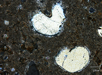
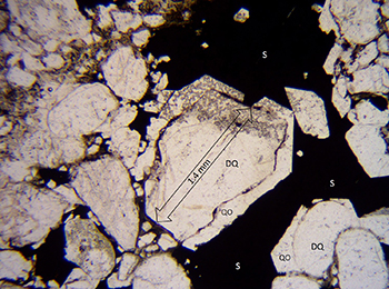
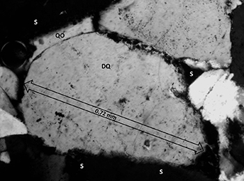
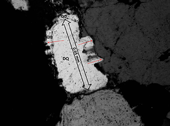
David Tonkin and Chester Wallace
Consultants
Download this article as a PDF (10.5 MB); cite as MESA Journal 94, pages 23–40
Published June 2021
Contents
Introduction
Geological setting
Lithological variation
Depositional environment
Petrology and diagenesis
Ore genesis
Discussion
Conclusion
References
Introduction
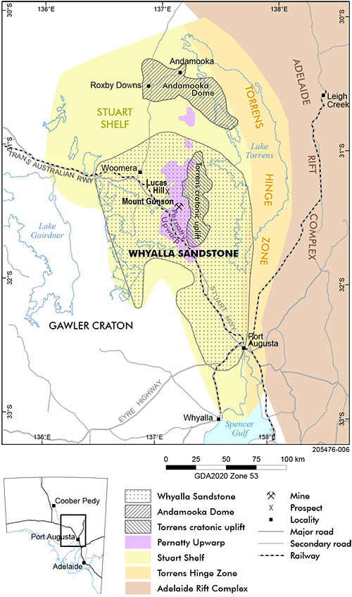
Figure 1 Regional geology location map showing the Adelaide Rift Complex, Torrens Hinge Zone and Stuart Shelf domains, the extent of the Whyalla Sandstone and the locations of the buried Andamooka Dome, Torrens cratonic uplift and Pernatty Upwarp structures.
Sandstone and quartzite rocks are known to contain exploitable metal deposits worldwide (Bjørlykke and Sangster 1991; Emsbo et al. 2016; Kelley et al. 2017; Cox et al. 2007; Tonkin and Creelman 1990). We applied a model that moves an oil-field brine through the Whyalla Sandstone (Neoproterozoic, Umberatana Group) to form sulfide minerals in pore-spaces and create replacement ore bodies. This model is based on migration of warm (80–140 °C) oil-field brine expelled from shale and shaly carbonate source rocks of the Neoproterozoic Callanna Group, Burra Group, or Umberatana Group via ancient seal bypass systems (Cartwright et al. 2007; Preiss 1999), to debouche into the Whyalla Sandstone. The warm oil-field brine contained organic acids, metals in complex ions and other reduced molecules. This diagenetic fluid was responsible for forming stratabound copper sulfide mineral deposits in the Whyalla Sandstone.
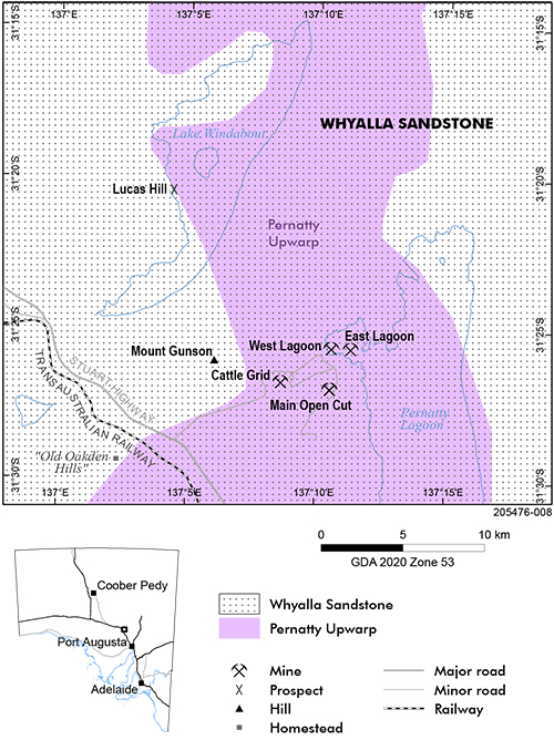
Copper deposits hosted by the Whyalla Sandstone in the Mount Gunson district of South Australia are an example of sediment-hosted, stratabound sulfide deposits (Figs 1–4). These deposits are found either within the Whyalla Sandstone, as in East Lagoon, West Lagoon and Lucas Hill deposits, or straddling the contact between the Whyalla Sandstone and the underlying redbeds of the Mesoproterozoic Pandurra Formation, as in the Cattle Grid and Main Open Cut mines (Fig 4).
In the period from the initial discovery of copper in 1875 up to the end of 1989, the Mount Gunson copper deposits produced about 149,000 t of copper metal, along with 65 t of silver metal as a by-product. Between 1974 and 1986, Cattle Grid mine, the largest deposit, produced 7.5 Mt of ore with a recovered grade of 1.7% Cu and 8.3 g/t Ag (Tonkin and Creelman 1990).
This paper describes a petrological investigation of the sandstone-hosted copper deposits in the Mount Gunson district. The investigation elucidates the depositional and diagenetic history of the Whyalla Sandstone and emphasises the importance of oxidation and reduction chemical reactions and the creation of secondary porosity in the deposition of sulfide mineralisation.
Geological setting
Structural outline
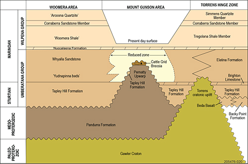
Figure 2 Time–rock diagram for the TORRENS map sheet area showing stratigraphic relationships for the Whyalla Sandstone. Note the erosional gap above the buried Pernatty Upwarp (after Tonkin 2007).
The Whyalla Sandstone forms part of a Neoproterozoic sequence of generally flat-lying sediments deposited on the Stuart Shelf, a cratonic platform bordering the rift and sag basins of the Adelaide Rift Complex (Lloyd et al. 2020) to the east (Fig 1). Distribution of the Whyalla Sandstone is largely contained within the area defined by the TORRENS and eastern portion of PORT AUGUSTA 1:250,000 scale map sheets. Although the Stuart Shelf sediments are flat-lying, they conceal significant buried structures in the underlying Paleoproterozoic and Mesoproterozoic rocks. The older sediments of the Stuart Shelf lap onto and pinch out against these buried structures (Fig 2).
Crystalline basement uplift
Between Pernatty Lagoon and Lake Torrens lies a buried northerly-trending cratonic uplift of the Gawler Craton crystalline basement (Fig 1). This basement structure is a major feature on the TORRENS map, comparable in scale to the west-northwesterly trending Andamooka Dome (O’Driscoll and Campbell 1997), which is a major feature on the ANDAMOOKA map.
Pernatty Upwarp
The southern part of the Stuart Shelf is dominated by the Pernatty Upwarp (Figs 1–4), a north-trending structural uplift of Mesoproterozoic red sandstones belonging to the Pandurra Formation (Drexel et al. 1993). Fanning et al. (1983) established the Rb–Sr age for the Pandurra Formation of 1424 ± 51 Ma, indicating that the unit is considerably older than previously thought and should not be considered part of the Neoproterozoic Stuart Shelf sequence. More recently, Beyer et al. (2018) reported that deposition took place between 1575 Ma (the youngest Hiltaba Suite age) and c. 1490 Ma, the 40Ar/39Ar age of for diagenetic illite in the basal Pandurra Formation.
Along the margins of this structural feature, lower strata of the Neoproterozoic sequence, including the Whyalla Sandstone, pinch out against redbeds of the Pandurra Formation (Fig 2). The underlying presence of the upwarp is apparently reflected in outcrop patterns of the upper sequence of the Neoproterozoic succession. This reflection appears as an embayment in the southern margin of the Arcoona Plateau. This embayment directly overlies the crest of the Pernatty Upwarp, which suggests the upwarp was responsible for faulting in the overlying sediments, resulting in accelerated erosion and removal of the sediments.
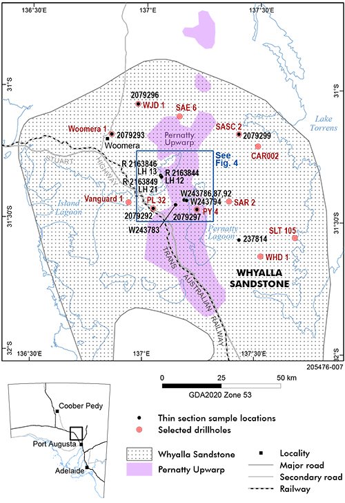
Figure 3 Petrology location map showing limits of Whyalla Sandstone, the Pernatty Upwarp, thin section sample locations and selected drillholes.
Rift basalts
Overlying the Pandurra Formation on the southeastern part of the Stuart Shelf is the tholeiitic Beda Basalt, which interfingers with sandstones and conglomerates of the Backy Point Formation (Fig 2). Isotopic dating has yielded a wide range of conflicting dates for the Beda Basalt, but an age of c. 830 Ma is cited by Wade et al. (2014) and is now generally accepted. This accords with the 827 ± 6 Ma baddeleyite age for the Gairdner Dolerite (Wingate et al. 1998), dykes of which intrude the Pandurra Formation and are interpreted as feeders to the Beda Basalt (Mason et al. 1978).
Neoproterozoic Stuart Shelf sequence
The oldest sediments of the Neoproterozoic Stuart Shelf sequence belong to the Sturtian age Tapley Hill Formation (Umberatana Group), which overlies the Beda Basalt – Backy Point Formation where that unit is present; otherwise Tapley Hill Formation directly overlies the Pandurra Formation (Fig 2). A maximum age for the base of the Tapley Hill Formation is 663.03 ± 0.11 Ma, which is the high-precision U–Pb zircon age of for the underlying Wilyerpa Formation in the Adelaide Rift Complex (Cox et al. 2018), where there is a significant post-glacial disconformity at the base of the Tapley Hill Formation.
The Tapley Hill Formation comprises grey to black dolomitic and pyritic, finely laminated siltstone and dolomite. On the eastern side of the Pernatty Upwarp, the Tapley Hill Formation grades up into the oolitic and stromatolitic Brighton Limestone. Re–Os dating yielded a minimum age of 643 ± 2.4 Ma for the Tapley Hill Formation (Kendall et al. 2006).
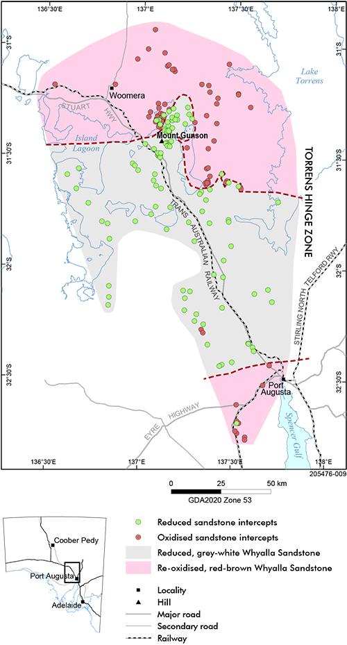
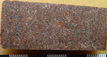
The Marinoan age Whyalla Sandstone directly overlies the Tapley Hill Formation in the deeper parts of the basin, but through the shallower section above the Pernatty Upwarp the Tapley Hill Formation was removed by erosion and Whyalla Sandstone lies directly on Pandurra Formation (Fig 2). The Whyalla Sandstone is a bimodal, lithic quartz sandstone, characterised by the extreme rounding of quartz grains in the coarse fraction and the presence of reddish coloured coarse lithic grains of probable felsic volcanic origin. At the type section in Cattle Grid Mine, it is grey-white and highly friable, exhibiting large-scale cross-bedding (Preiss 1987), but distal to the Mount Gunson mines area iron oxide, coating grains or in the matrix, gives the Whyalla Sandstone a red-brown colour (Fig 5).
Figure 5 Geological map showing the distribution of the reduced and late-stage re-oxidised facies of the Whyalla Sandstone, as interpreted from historical drillhole records, and the individual locations of reduced sandstone and oxidised sandstone intercepts. Note the influence of the Pernatty Upwarp on the shape of the redox boundary north of Mount Gunson (after Tonkin 2007).
Above the Whyalla Sandstone is a thin, lenticular dolomitic layer, the Nuccaleena Formation (Fig 2). In the Adelaide Rift Complex this unit marks the end of the Marinoan glacial episode and the base of the Ediacaran Period (Knoll et al. 2006).
The upper section of the Neoproterozoic sequence is represented by the Ediacaran Tent Hill Formation, named after the flat-topped buttes this unit forms on the southern Stuart Shelf, including Mount Gunson itself. To the north and east of Mount Gunson the Tent Hill Formation forms the Arcoona Plateau. The formation comprises 3 members: the Tregolana Shale Member, which is a reddish-brown laminated shale and siltstone; the Corraberra Sandstone Member, made up of thin beds of purple-brown sandstone, siltstone and shale; and the Simmens Quartzite Member, a silicified quartz sandstone, which is cream in colour where it outcrops on top of the Arcoona Plateau and capping the ‘Tent Hills’, although we have seen red-coloured Simmens Quartzite in some deep drillhole cores.
Lithological variation in the Whyalla Sandstone
At the type section in the Cattle Grid Mine at Mount Gunson (Preiss 1987) the Whyalla Sandstone is a friable, bimodal, lithic sandstone. The coarse fraction is composed dominantly of 1–2 mm large very well rounded to spherical detrital quartz grains, together with characteristic reddish lithic grains and lesser feldspar grains. The quartz grains typically have a frosted surface. Textures in the dominant reddish lithic grains suggest the presence of relict phenocrysts, suggesting a felsic volcanic origin. Lithic grains derived from granitic, metamorphic and sedimentary rocks are also present. The fine fraction (50–200 μm) is composed of subrounded to subangular fragments of quartz, feldspar and lithic grains (Williams et al. 2008). The fine fraction occurs both as laminae that contain no coarse grains and as a matrix in the coarse fraction.
In mine exposures of the Cattle Grid and Main Open Cut area, and in outcrops in the Mount Gunson area, the Whyalla Sandstone is dominantly a grey-white colour, weathering to yellowish grey in mine exposures. The Whyalla Sandstone is generally poorly exposed regionally, but in limited outcrops to the south and west of Pernatty Lagoon, on Oakden Hills, Yudnapinna and South Gap pastoral stations, the Whyalla Sandstone is generally also a grey-white colour. In the East and West Lagoon mines, the Whyalla Sandstone was greyish-pink before mining, but after exposure and weathering the rock soon deteriorated to become grey-white and highly friable.
Sedimentary structures displayed in the Cattle Grid mine are dominated by low-angle (≤15°) large-scale cross-bedding, with sets up to 7 m thick and a variety of periglacial structures (Williams et al. 2008). Cross-bedding and periglacial structures are also present at Main Open Cut mine.
To the south and west of the Pernatty Upwarp the Whyalla Sandstone grades down into the informally named Yudnapinna beds. The Yudnapinna beds overlie the Tapley Hill Formation and generally consist of red, green and grey-green siltstone and fine sandstone, with a carbonate matrix at many locations. Like the overlying Whyalla Sandstone, the Yudnapinna beds contain abundant reddish lithic grains, which range from sand to small pebble size. The name was originally used by Tonkin (1974) to identify poorly consolidated silty sediments encountered in rotary air blast drillholes east of Yudnapinna homestead, but no outcrop of Yudnapinna beds was identified. However, the name has been used widely in exploration company drill logs and is clearly a recognisable stratigraphic unit within the Whyalla Sandstone. Therefore, it is suggested the unit be upgraded to Yudnapinna Member, representing the basal member of the Whyalla Sandstone. A type section is proposed in CSR Ltd drillhole PL 32 (SA Geodata drillhole 20720; 31° 27’ 41”S, 137° 2’ 27”E) between 163.00 and 212.25 m depth.
The Whyalla Sandstone is not always a bleached grey-white colour. Inspection of old drill cores (and scanned core imagery) stored at the South Australia Drill Core Reference Library showed that in some places exploration drillholes intersected red, hematite-cemented Whyalla Sandstone. For instance Woomera 1 (18057; historically known as Woomera Bore), located 40 km northwest of Mount Gunson (Fig 3), intersected mainly red Whyalla Sandstone between the depths of 239 and 341 m (Thomson and Johnson 1968). Western Mining hole WHD 1 (25359) at Whittata Hill, 40 km southeast of Mount Gunson, intersected mainly red Whyalla Sandstone and Yudnapinna beds between the depths of 225 and 279 m (Paterson and Muir 1986).
A review of historical exploration drill logs revealed a regional pattern in the distribution of oxidised (red) and reduced (grey-white) lithofacies of the Whyalla Sandstone (Tonkin 2007). Based on the colour of the sandstone described in drill logs, mapping defined a boundary between generally red sandstone and mainly grey-white sandstone (Fig 5). An attempt to explain this pattern prompted this petrological investigation. Our initial working hypothesis was that the oxidised red facies represents unaltered Whyalla Sandstone and that the grey-white facies represents alteration by warm migrating basin fluids that contained reduced molecules. Subsequent petrology revealed a much more complex picture: the entire Whyalla Sandstone was probably chemically reduced during secondary diagenesis and the red Whyalla Sandstone reflects a post-reduction, late-stage oxidation event.
Depositional environment of the Whyalla Sandstone
The Whyalla Sandstone on the Stuart Shelf is at least the partial lithostratigraphic equivalent to the Elatina Formation in the Adelaide Rift Complex, to the east. The Elatina Formation consists mainly of shallow marine sandstones, but also includes diamictite lenses of glacial origin (Preiss et al. 1998). A similarity between the 2 units was mentioned by Johns (1968), who noted a strong resemblance between pebbly grits at Mount Gunson and parts of the Elatina Formation. RP Coats (Preiss 1987) also recognised the strong similarity between the grains of very well rounded and spherical quartz in the Whyalla Sandstone and those in certain ‘trains’ or granule-bearing layers in the Elatina Formation. Drillhole intersections from the eastern Stuart Shelf and Torrens Hinge Zone (Thomson 1970) show that the Whyalla Sandstone interfingers with units of the Elatina Formation. This interfingering represents probable glaciomarine incursions into the otherwise terrestrial environment of the Stuart Shelf at that time. In fact, on the southeastern Stuart Shelf the glacial interval intersected in several drillholes includes interbedded sediments of both Whyalla Sandstone and Elatina Formation, so potentially the Whyalla Sandstone and Elatina Formation may overlap completely (WV Preiss, pers comm, 4 March 2020). Reporting on the southernmost part of the Stuart Shelf, McAvaney et al. (2016) considered the Whyalla Sandstone could be correlated with the Marinoan glaciomarine Elatina Formation and that silty and shaly intervals in the upper part of the Whyalla Sandstone could be correlated with the Reynella Siltstone Member.
An aeolian origin for the Whyalla Sandstone was first inferred by CSR Ltd petrologist PJ Curtis (Curtis 1972), following a binocular microscope study of samples of Whyalla Sandstone and Pandurra Formation taken from percussion drillholes representing various parts of the Mount Gunson mine leases. The purpose of that study was to investigate the surface characteristics of the detrital quartz mineral grains, i.e. the frosting. Curtis compared the Whyalla Sandstone samples with samples collected from Coogee Beach in New South Wales and with Mount Gunson dune sand. Curtis described a bimodal character for the Whyalla Sandstone, although did not use the term bimodal. He noted the presence of coarse and fine fractions, interpreting the coarse fraction as being of largely aeolian origin and the fine fraction as lacustrine silt and clay. He reported that large grains are ‘frequently perfectly round, (and) show heavy frosting, scour and sub-parallel scratches’. Coarse grains from Cattle Grid area were described as ‘coarsely frosted, pitted, gouged and scratched’. Curtis considered the surface frosting and pitting probably resulted from aeolian influences, comparing them to the type of attrition observed in desert dune sands. However, he considered the fine fraction resulted from secondary deposition of the aeolian sand by floodwaters, with the addition of fine material from adjoining playas. By comparison, in samples of Coogee beach sand the quartz grains were less coarse, angular to subangular and showed only light frosting. Scouring and scratching was noticeably absent. On the Mount Gunson dune sand grains, Curtis found subparallel scratches parallel to the grain long axis and found gouging and pitting on the faces of large grains. He concluded from this that the sand grains of the dunes were derived from the Whyalla Sandstone.
Curtis’s work influenced subsequent ideas regarding a connection between frosting of quartz grains and possible aeolian deposition of the Whyalla Sandstone (Gersteling and Heape 1975; Preiss 1987). However, a strong similarity has been noticed between outcrops of bleached, friable Whyalla Sandstone and hydrocarbon-bearing sandstones found in a number of ancient sedimentary basins, such as the Surat Basin in Queensland, the Arabian Platform in Saudi Arabia, the Paradox Basin in Utah and Colorado, USA, and the Anadarko-Ardmore Basins in Oklahoma, USA (Wallace and Jacobs 2013). Frosting of quartz grains in those sandstones was due to acid etching by warm reduced fluids related to oil-field brines. The reduced fluids also removed matrix material, increasing porosity and rendering the rocks extremely friable. The petrological investigation of the Whyalla Sandstone reported in this paper strongly supports the acid etching hypothesis, i.e. in our opinion the surface frosting of quartz grains in the Whyalla Sandstone is the result of acid etching caused by the migration of a warm fluid, such as an oil-field brine, that contained reduced molecules.
Tonkin and Williams (1983) reported very large scale cross-bedding in the Whyalla Sandstone, which may be a result of aeolian deposition, but because of its locally pebbly character, the presence of channel forms and its unimodal paleocurrent directions, thought it was best interpreted as a glaciofluvial outwash deposit (Williams 1983). Williams and Tonkin (1985) described ‘subcritically climbing translatent strata’ associated with the large-scale cross-bedding at Cattle Grid mine. These characteristics are considered diagnostic of aeolian deposition (Hunter 1977), although Preiss (1987) noted that the broad channel-like forms of the cross-bedding and the pebbly nature of the sandstone are also consistent with fluvial deposition.
At the type section in the Cattle Grid mine, the Whyalla Sandstone overlies silicified and brecciated Pandurra Formation, which is host to copper sulfide mineralisation (Gersteling and Heape 1975). The breccia host rock (Cattle Grid Breccia; Fig 2) formed through in situ frost shattering of silicified Pandurra Formation during the Elatina (Marinoan Epoch) glaciation in the Adelaide Rift Complex (Tonkin and Williams 1983; Williams and Tonkin 1985; Williams 1998; Williams et al. 2008). Many periglacial structures at the Cattle Grid mine involve both Whyalla Sandstone and Cattle Grid Breccia, including: primary sandstone wedges that penetrate downwards into Cattle Grid Breccia; diapiric tongues of breccia that penetrate upwards into Whyalla Sandstone; and frost-heave blocks of quartzite uplifted as much as 3 m above the base of the Whyalla Sandstone. Similar periglacial structures are also present at the Main Open Cut and East Lagoon mines (Tonkin 1982).
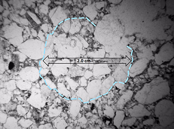
Figure 6 Photomicrograph showing a ‘clot’ (outlined in blue) preserved in bimodal Whyalla Sandstone. The annular alignment of the long axes of detrital grains defines the external boundary of the clot. No adhesive is preserved within the clot, but ice was probably the original cement, considering the inferred periglacial origin of the Whyalla Sandstone in some areas. Drillhole LH 17, 71.47 m, author photo R-2163848-b. (Photo 418334)
The periglacial heritage of the Whyalla Formation may be preserved in thin sections of sandstone; in 2017 Wallace noted that ‘clots’ occurred in some thin sections. These clots contain bimodal sand grains arranged in an annular pattern that may have been agglutinated, because the clots cut across sedimentary laminations (Fig 6). Most clots are about 2 cm in diameter and are composed of quartz grains, which are of medium and coarse sand size. The clots are different from ‘till pellets’, as described by Li et al. (2013), because till pellets contain abundant fine-grained material, whereas these clots primarily contain bimodal sand-sized grains typical of the Whyalla Sandstone.
Speculation about the origin of the clots depends on the nature of the original agglutinating material. The cement could have been ice or an organic material, although none is preserved. Increasing temperature during burial diagenesis would have melted any ice cement. Oxidation during a later stage of alteration diagenesis would have destroyed any organic cement (for instance algae or bacteria). If the cement was ice, it would be consistent with a periglacial origin, where the clots could have formed in cold water in the swash zone, or perhaps in a niveo-aeolian environment (Koster and Dijkmans 1988). We favour a periglacial origin for the clots, which would be consistent with other periglacial features seen at Mount Gunson and with the regional correlation of the Whyalla Sandstone with the Elatina Formation.
Williams (1998) identified sedimentary features of the Whyalla Sandstone that indicate an aeolian origin. These include: large-scale cross-bedded sets up to 7 m thick with dips generally ranging between 20 and 23°; grainfall and grainflow deposits; inversely graded subcritically climbing translatent strata; and pin stripe laminations. However, in the basal 5 m Williams (1998) identified periglacial cryogenic structures, including: primary sand wedges; drop involutions; periglacial injections; frost-heaved blocks; water-escape structures and thermokarst microtopography. Taken together with the prevalence of low-angle strata, these features accord with a periglacial sand-sheet environment, with dune forms near the centre of the sand sheet (Williams 1998; Williams et al. 2008).
The origin of the bimodal texture of the Whyalla Sandstone is probably critical in understanding its depositional history. Taira and Scholle (1979) identified 6 depositional environments in which bimodal sandstones could form, namely:
- fluvial channels with trough cross-stratification
- barchan dunes
- aeolian megaripples
- lower beach foreshore
- beach storm deposits
- inner tidal flat deposits.
Wallace (2015) concluded that there are 2 main types of bimodal sandstone textures:
- Those resulting from a mechanism that moves 2 different grain sizes at the same time.
- Those resulting from the mixing of 2 different grain sizes at the site of deposition.
Of the 6 options identified by Taira and Scholle (1979), only transport in fluvial channels provides an origin for bimodal sandstone with the capacity to transport 2 different grain sizes in one event. Because the channel-like forms of the cross-bedding at Cattle Grid also supports a fluvial origin for the sandstone, it seems possible that the bimodal textures in the Whyalla Sandstone resulted from a fluvial mechanism that transported both coarse and fine grains in the same flow regime. This transport mechanism would require that both coarse- and fine-grained sand were found separately in the source area. The largest grains would determine the maximum stream power needed for transport (Wallace 2015).
This fluvial model echoes the dual source origin for the Whyalla Sandstone found in the observations by Curtis (1972), Williams (1998) and Williams et al. (2008), but perhaps there is insufficient field evidence to support a single hypothesis. A consideration when evaluating the periglacial model is that periglacial structures are restricted to the Pernatty Upwarp, where paleoerosion removed most of the Tapley Hill Formation (Fig 2), leaving only small erosional outliers, which lie in depressions on the paleosurface of the Pandurra Formation. Tapley Hill Formation outliers have been identified at several locations, including Windabout copper deposit, Powerline Embayment, Bellamy Wells, Birthday Siding, Sweet Nell mine and Fair Nell mine (Tonkin 1979b). Evidence for paleo-exposure of the upper surface of the Tapley Hill Formation is also found at MG 14 copper deposit and the Birthday Siding outlier (Tonkin 1982).
On top of the Pernatty Upwarp, interpenetrating periglacial structures are found between the basal Whyalla Sandstone and the underlying brecciated Pandurra Formation (Cattle Grid Breccia). Around the flanks of the Pernatty Upwarp, interpenetrating structures of possible periglacial origin are found between basal Whyalla Sandstone and the underlying brecciated Tapley Hill Formation, e.g. at the MG 14 copper deposit in drillholes MG 23-2 (352271) and MG 69/2 (Mount Gunson Mines Pty Ltd 1975). Away from the Pernatty Upwarp there is no record of periglacial activity at the base of the Whyalla Sandstone.
Petrology and diagenesis of the Whyalla Sandstone
Defining diagenesis
For exploration purposes we are only concerned with 2 processes: diagenesis that closes pore space (burial diagenesis) and diagenesis that opens pore space (alteration diagenesis). Burial diagenesis refers to all the chemical reactions that are needed to close pore space and thus form a rock from sediment. It includes (but is not limited to) precipitation of quartz, illite and carbonate cements. The first chemical change is the formation of iron oxide coatings on quartz through dissolution of labile grains in soils that form on debris fans of arid and tropical deposits (Walker 1967). Alteration diagenesis includes all processes that open secondary porosity, which includes dissolution of quartz, carbonate and feldspar. Precipitation of sulfide minerals followed or accompanied the late stages of alteration diagenesis.
The diagenesis of the Whyalla Sandstone was complex and no single investigated sample displays a complete diagenetic history. An interpreted diagenetic history has been compiled from examination of the diagenetic sequence from multiple samples (Wallace 2017). Burial diagenesis is recorded sequentially in the formation of hematite, quartz and clay minerals. These oxidised minerals are typical of subsiding sedimentary basins worldwide. Alteration diagenesis is recorded by the formation of fluorite, barite, chlorite and sulfide minerals. These minerals are formed in direct and indirect reduction cells and are common products found in the clastic rocks of oil-producing basins (Bouabdellah et al. 2014; Bottoms et al. 2019). Minerals formed during late-stage migration of meteoric water formed oxidising fluids that resulted in hematite and carbonate precipitation.
Burial diagenesis
Iron oxide mantles
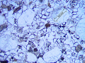
Soon after deposition, the Whyalla Sandstone was coloured red by coatings of iron oxide released from the disintegration of labile minerals and rock fragments (Fig 7a). Walker (1967) and Walker and Honea (1969) demonstrated that early changes to sediment in arid and semi-arid environments changed the sediment to a reddish colour by oxidation of mafic grains; the oxidised material coated the detrital grains with iron oxide. The original red colour of the Whyalla Sandstone is rarely preserved, in contrast to the contemporaneous Elatina Formation, where the red colour is mostly well preserved in the sandstones, including those that form tidal rhythmites, in which paleomagnetic studies demonstrate that the hematite was deposited very early, pre-dating lithification (Schmidt et al. 1991; Schmidt and Williams 1995).
Syntactic quartz overgrowths
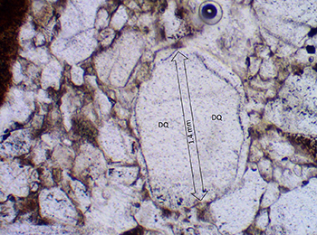
Generally, early diagenesis and cementation of the Whyalla Sandstone is represented by the deposition of authigenic quartz overgrowths. At most places, trains of fluid-filled vacuoles mark the boundary between detrital grains and the enclosing quartz overgrowths. These vacuole trains replaced the original iron oxide coating (Fig 7b).
Figure 7 Photomicrographs of Whyalla Sandstone showing evidence of burial diagenesis.
7(a) Reduction of Whyalla Sandstone is incomplete and some coatings of a red iron oxide mantle still remain on detrital quartz grains. Note the bimodal aspect of the Whyalla Sandstone and the difference in rounding of large framework grains and matrix grains. Drillhole PY 4, 35.75 m, author photo 2079297-a. (Photo 418335)
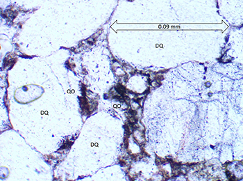
7(b) Syntactic quartz overgrowths enclose a large detrital quartz grain (DQ) in bimodal Yudnapinna beds. The detrital grain boundary is defined by trains of fluid-filled vacuoles. Iron oxide rims were probably removed by paraffin molecules in early formation fluids. Drillhole PL 32, 165.5 m, author photo 2079292-a. (Photo 418336)
Alteration diagenesis
The transformation from a red rock to a buff or light-grey rock probably took place at shallow depths. Early reductants not only replaced iron oxide with fluid-filled vacuole trains, which define the boundaries between detrital grains and syntactic quartz overgrowths (Fig 7b), but also precipitated carbonate and illite/chlorite in some pore spaces.
The early mantles of iron oxide on detrital grains were removed by migrating fluids that contained reductants. These were most likely biogenic gases of the paraffin class (methane, butane, propane and ethane) and possibly simple chains of paraffin liquids. In one sample (Fig 7a) reduction was incomplete and some iron oxide mantles remain. The migrating fluid that contained the reductants was similar in composition to an oil-field brine, and was warm, saline and relatively metal rich (Wallace 2015).
Quartz dissolution
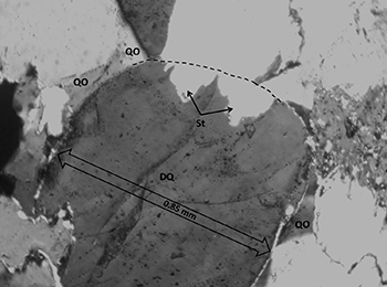
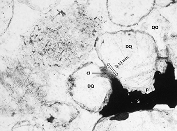
The most important diagenetic feature for mineralisation in the Whyalla Sandstone is the dissolution of detrital and authigenic quartz and matrix clay minerals (Figs 8a–c). This feature is more important than the processes of oxidation and reduction involved in mineralisation. A major event of quartz dissolution preceded or accompanied the mineralisation event and this dissolution took place under reducing conditions. Quartz is resilient to dissolution in most environments, but during sulfide mineralisation of the Whyalla Sandstone matrix clays, micas and both authigenic and detrital quartz became unstable (Wallace 2017).
Sutured quartz contacts
A specific, easily recognised texture of authigenic quartz associated with mineralising fluids is one of interlocking quartz overgrowths with discontinuous sutured, or crenulated contacts (Figs 8d, e). Silica was precipitated in optical continuity with quartz overgrowths that formed during burial diagenesis, but because quartz was precipitated quickly and under the stress of adverse temperature conditions, contacts are sutured. Sutured contacts are an obvious departure from textures of authigenic quartz formed during burial diagenesis and may be indicative of added quartz, possibly resulting from an ample supply of silica in solution.
Figure 8 Photomicrographs of Whyalla Sandstone showing evidence of alteration diagenesis of quartz.
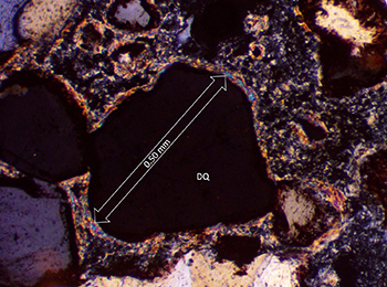
8(a) Extreme dissolution of rounded detrital quartz grains and syntactic quartz overgrowths in altered Whyalla Sandstone exposed in an interpreted fluid expulsion structure at Toby Swamp. Matrix mineral is carbonate. Crossed nicols. Toby Swamp, hand specimen, sample 237814, IR Pontifex photo P5080451. (Photo 418337)
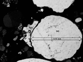
8(b) Dissolution textures in sample from Cattle Grid mine. Detrital quartz grains (DQ) have syntactic quartz overgrowths (QO) that form euhedral quartz crystal faces adjacent to a sulfide vein (S). These overgrowths are much larger than those found in burial diagenesis, indicating that an early fluid precipitated secondary quartz and a second fluid, accompanying sulfide precipitation, dissolved quartz back to crystal faces. Small quartz grains with no overgrowths (left side of photo) are probably remnants left after quartz dissolution. Hand specimen, author photo W-243783-a. (Photo 418338)
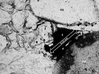
8(c) Detrital quartz (DQ) shows an irregular embayed boundary where sulfide minerals (S) replaced both quartz overgrowths (QO) and detrital quartz. Plain light. East Lagoon mine, hand specimen, author photo W-243794-a. (Photo 418339)
Fluorite, barite and chlorite
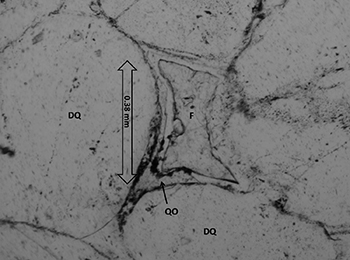
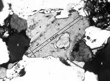
Sulfide mineralisation in Whyalla Sandstone is generally accompanied by fluorite as a cement, often with associated barite cement (Figs 9a–c). Fluorite and barite cements are indicators of redox chemical reactions in rocks. The presence of fluorite is significant because fluorite is associated with certain types of mineral deposits worldwide, including Mississippi Valley type deposits and copper sulfide deposits (Bottoms et al. 2019; Richardson and Pinckney 1984; Bouabdellah et al. 2014; Majzlan et al. 2016).
Barite is found as a gangue mineral associated with Mississippi Valley type deposits (Kesler 1996). On the Colorado Plateau, barite cement is found associated with asphalt, native gold, and platinum group metals in sandstone.
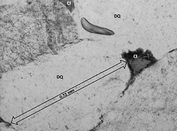
Chlorite group minerals fill pore spaces and form mantles on detrital grains of altered Whyalla Sandstone (Figs 9d, c). Mantles of chlorite/illite and the presence of chlorite in pore spaces are positive indicators of reductants in migrating fluids. The authigenic chlorite in altered Whyalla Sandstone may be the result of a chemical reduction reaction that involved illite (or some other clay), hydrocarbons and hematite (Surdam et al. 1993, p. 1511) at 100 °C. The presence of the chlorite minerals (there may be more than one), which form rims on detrital grains and infill interstices, suggests chemical reduction reactions involving acetic acid, an acid that is unstable above 130 °C, but is common in oil-field brines below that temperature.
Figure 9 Photomicrographs of Whyalla Sandstone showing evidence of alteration diagenesis of fluorite, barite and chlorite.
9(a) A sulfide grain (S) occupies a former pore space between detrital quartz grains (DQ) and an altered volcanic rock fragment (VRF). Fluorite (F) occupies the remainder of the former pore space. The pore space was left open after syntactic quartz overgrowths (QO) formed during burial diagenesis. Drillhole LH 12, 53.13 m, author photo R-2163844-a. (Photo 418342)
9(e) Chlorite (Cl) fills pore spaces between detrital quartz grains (DQ). The occurrence of chlorite in pore spaces indicates the former presence of reducing molecules in migrating fluids (oil-field brine; Surdam et al. 1993). West Lagoon Mine, hand specimen, author photo W-243792-b. (Photo 418346)
Carbonate
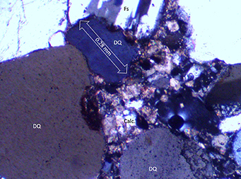
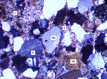
Carbonate replaces both detrital quartz and quartz overgrowths on a small scale in some places, where some pore spaces that appear to have remained open are lined with very fine grained carbonate and occluded pore spaces are filled with clear carbonate, or with clear carbonate and authigenic quartz (Fig 10a). In other places carbonate cement has closed porosity (Fig 10b).
Figure 10 Photomicrographs of Whyalla Sandstone showing evidence of alteration diagenesis of carbonate.
Sulfide minerals
Incipient sulfide mineralisation is found in reduced Whyalla Sandstone at some locations, where the sulfide replaces quartz (Fig 11a). The beginnings of an ore deposit are seen in Lucas Hill drillhole LH 12 (139814) (Fig 11b), where sulfide minerals replaced syntactic quartz cement. Economic copper sulfide mineralisation is found in the Whyalla Sandstone at Mount Gunson mines, in the West Lagoon and East Lagoon deposits (Figs 8c; 11c, d). Subeconomic mineral deposits are found in the Whyalla Sandstone at Mount Gunson mines at several deposits, including at Main Open Cut, at House and to a lesser extent Cattle Grid. Subeconomic mineralisation is also found in Whyalla Sandstone at Lucas Hill prospect, 15 km northwest of Mount Gunson mines. In mineralised Whyalla Sandstone at the Lucas Hill prospect, sulfide minerals precipitated in pore spaces after dissolution of detrital quartz and quartz overgrowths and after chlorite minerals were precipitated (Fig 9a).
Figure 11 Photomicrographs of Whyalla Sandstone showing evidence of alteration diagenesis of sulfide minerals.
11(a) Incipient sulfide mineralisation (S) forms ragged replacement masses and small pelletal forms in reduced bimodal Whyalla Sandstone. Detrital quartz (DQ). Plain light. Drillhole PSC 4 SASC 2, 327.75 m, author photo 2079299-d. (Photo 418349)
11(c) Sulfide boundaries (S) define the etched limits of detrital quartz grains (DQ). Matrix grains and clay minerals were dissolved on a molecular scale during the mineralising process. Syntactic quartz growths are indicated by ‘QO’. Plain light. West Lagoon Mine, hand specimen, author photo W-243786-a. (Photo 418351)
11(d) Massive sulfide minerals selectively replaced fine-grained matrix quartz and matrix clay minerals. Sulfide (S) embays both syntactic quartz overgrowths and detrital quartz grains (DQ). Detrital grain boundaries are defined by fine-grained sulfide minerals. Plain light. West Lagoon Mine, hand specimen, author photo W-243786-c. (Photo 418352)
Late-stage diagenesis (oxidation)
In some places the Whyalla Sandstone looks in hand specimen to be a normal redbed deposit, oxidised during burial diagenesis, with a dusting of iron oxide mantling detrital quartz grains and giving the rock an overall reddish colour (Fig 12a). This was the assumption when Tonkin (2007) defined a regional redox boundary within the Whyalla Sandstone (Fig 5). However, petrological investigation showed that in many places early diagenetic iron oxide coatings on detrital quartz grains were later removed by reduced fluids, either during burial diagenesis or during alteration diagenesis. The reddish colouration of Whyalla Sandstone found in some places, such as drillholes Woomera 1, WJD 1 (18093) and PRL 3 / SAR 2 (20716), is due to pore spaces that contain late-stage iron oxide (Fig 12b). These rocks are red because late-phase diagenetic fluids brought iron oxide into the system. When this late-stage oxidation event occurred is not known.
Figure 12 Examples of Whyalla Sandstone showing evidence of late-stage diagenesis (oxidation).
12(b) Detrital quartz grains (DQ) and rare syntactic overgrowths (QO) are mantled by extremely fine-grained carbonate; thickness of mantles ranges from a layer of dust to as much as 0.05 mm. Pore spaces are filled with a mixture of carbonate minerals, ‘clay’ minerals, authigenic quartz and iron oxide. Woomera 1, 284.65 m, author photo 2079293-a. (Photo 418354)
Ore genesis
The formation of the copper deposits at Mount Gunson can be described in terms of a ‘mineral system’, as defined by Wyborn et al. (1994). The components of a mineral system include: sources of the transporting fluids; sources of the metals; fluid migration pathways; a thermal gradient; an energy source; a focusing mechanism; and chemical and/or physical traps for precipitation.
Source of metals
Previous investigators suggested several possible sources for the metals. Dickinson (1942) thought the metals were originally leached from mafic rocks at depth. Knutson et al. (1992) arrived at a similar conclusion, suggesting the metals were ultimately derived from a mafic to intermediate igneous source, probably the Mesoproterozoic Gawler Range Volcanics. This investigation indicates that the metals were liberated to formation fluids from metal-rich Neoproterozoic source rocks such as the Tapley Hill Formation and the Beda Basalt. Wallace (2008) identified 2 probable types of source rocks:
- Volcanic rocks, like the Beda Basalt, and immature, oxidised arkoses and related sediments. Metals thought to be easily dissolved from oxidised sediments and transported as complex chloride or organic ions include U, V, Cu, Au, Ag, Pb, Zn, and Co. All of these reported in significant concentrations in Cattle Grid concentrates (Tonkin 1979a).
- Mineralogically immature reduced shales, argillaceous siltstones and greywackes, which are commonly associated with hydrocarbon generation, such as the Tapley Hill Formation. Carbonaceous shale, marl, argillaceous siltstone and black shale generally contain anomalous concentrations of Ag, Cr, Cu, Mo, Ni, Pb, V, U, Zn, Au, Co, Ba, rare earth elements and platinum group metals. Most of these metals are also reported in Cattle Grid concentrates.
Source of mineralising fluids
This investigation supports earlier inferences that basin brines transported metals to the sites of deposition at Mount Gunson. A fluid inclusion study by Busbridge (1981) indicated that inclusions formed at temperatures of about 120 °C, which suggested a basin-brine model. Lead isotope studies by Creelman (1983) and Gulson (1986) supported that conclusion.
Evidence from this investigation broadly supports earlier work. Fluorite as seen in Figure 9b would have been deposited from halide-rich fluids at about 100–150 °C (Cunningham and Heyl 1980; Wallace 2017). Micro-stylolites and sutured contacts are similar in texture to those formed under pressure in the North Sea oil fields at burial depths of 3,350–4,270 m, where the temperature at maximum burial was 120 °C (Burley 1986; Wallace 2017). This is not to say the Whyalla Sandstone actually had 3–4 km of cover; heat-flow may have been greater in Proterozoic time, or the Delamerian Orogeny could have increased or decreased the geothermal gradient locally.
Dissolution of quartz, as seen in Figure 11d, was probably caused by highly saline fluid containing reductant molecules at a temperature of 100–150 °C (Tester et al. 1993; Wallace 2017). Authigenic chlorite, as seen Figure 13, probably resulted from chemical reduction involving a clay such as kaolinite (or illite), along with hydrocarbons and hematite, at a temperature of 100 °C (Surdam et al. 1993). The texture where chlorite minerals formed rims on detrital grains and filled interstices suggests chemical reduction reactions that involved acetic acid, which is unstable above 130 °C, but is common in oil-field brines below 130 °C (Surdam et al. 1993; Wallace 2015).
Figure 13 Clay or chlorite mantle on detrital quartz (DQ) in Whyalla Sandstone overburden. Crossed nicols. Cattle Grid Mine, hand specimen, author photo W-243783-b. (Photo 418355)
Source of sulfur
Several researchers proposed that the sulfur in the metal sulfide deposits at Mount Gunson is the result of reduction of sulfate in groundwaters by sulfate reducing bacteria (Baas Becking and Moore 1961; Lambert et al. 1971; Creevy and Donnelly 1974).
This investigation indicated that sulfur was introduced with the mineralising fluids, and void-filling sulfide masses were deposited in the final stages of alteration diagenesis. The sulfides were deposited from warm, saline fluids that contained reductant molecules (Wallace 2017). At West Lagoon (Fig 14) massive sulfide shows no mineral boundaries and embays detrital quartz grains and their overgrowths. Sulfides occupy pore spaces and the spaces between detrital grains. Space was made for the precipitation of sulfide by dissolution of small quartz grains, interstitial clay and fine-grained mica, before massive sulfide minerals were deposited on a molecule-by-molecule basis. At East Lagoon (Fig 8c) mineralising fluids dissolved authigenic quartz and parts of detrital grains, which were then replaced by sulfide minerals on a molecular scale.
Figure 14 Detail of the bounding mantle of fine-grained sulfide minerals on detrital quartz (DQ). The uneven boundary suggests the fluid that deposited sulfide minerals was corrosive to detrital quartz. Sulfide minerals (S) replaced matrix grains and corroded the coarse detrital grains (DQ) in Whyalla Sandstone. The corroded grain boundaries suggest a molecule-by-molecule replacement of quartz by sulfide minerals. Plain light. West Lagoon Mine, hand specimen, author photo W-243787-a. (Photo 418356)
Fluid conduits and focusing mechanism
The strata of the Adelaide Superbasin (Lloyd et al. 2020) had abundant porosity at the time of deposition. Sandstone and quartzite units would have preserved porosity through burial diagenesis and some of these units would have been ‘opened’, acting as lateral conduits to oil-field brine and gases, liquid petroleum and mineralising brines. Units like the Angepena Formation, Wilmington Formation, Gumbowie Arkose, Grampus Quartzite and their lateral equivalents could have provided lateral conduits.
The vertical breccia pipes represented by the diapirs of the Adelaide Fold Belt could have provided vertical zones of great porosity that moved great volumes of mineralising water (oil-field brine) upward to younger units that retained porosity, thereby spreading mineralising fluids laterally throughout the basin. Structures in the Torrens Hinge Zone, a zone of tectonic transition between the stable Gawler Craton beneath the Stuart Shelf and the Adelaide Rift Complex to the east, could also have provided conduits for increased migration of diagenetic fluids.
The high porosity of the Whyalla Sandstone would have permitted increased migration of mineralising diagenetic fluids. These would have been concentrated by the progressive thinning of porous strata as they moved towards the crest of the Pernatty Upwarp, confined by an overlying caprock, the Nuccaleena Formation and/or Tregolana Shale, and forming economic mineral deposits at geologically favourable locations, such as the Mount Gunson mines.
Discussion
Silicified Whyalla Sandstone capping
A question to consider is the final destination of the silica that was dissolved during alteration diagenesis. Was this the silica source for the widespread silicification of the upper several metres of the Whyalla Sandstone in the Mount Gunson region? A silicified layer, generally 1–3 m thick, is found at the top of the Whyalla Sandstone in the Mount Gunson mines area, where it forms an eroded plateau surface. The areal extent of the silicification is uncertain, because its presence is unreported in the drill logs of some companies, but recorded intercepts in more than 150 CSR Limited drillholes in the Lucas Hill (LH), Lake Windabout (LW), Elizabeth Creek (EC), Oakden Hills (OK), Powerline (PL) and Mount Gunson (MG) areas suggest an extent roughly matching the area of reduced Whyalla Sandstone (Fig 2). The silicification is found even beneath the cover of Neoproterozoic Tregolana Shale (e.g. in CSR holes PL 32, 20720; and LH 13, 139815), so it cannot be explained solely by Cenozoic exposure and silicification events, although that probably played a part in some places.
However, the silicified layer might alternatively be the result of Neoproterozoic exposure; there is a regional disconformity or low-angle unconformity at the base of the Wilpena Group (Preiss 2000), and Plummer (1978) reported local disconformities at the base of the Wilpena Group (Tregolana Shale/Nuccaleena Formation equivalent) in the Adelaide Rift Complex.
Pernatty Lagoon ironstone deposits
The removal of the early hematitic matrix from the Whyalla Sandstone would have involved the relocation of a substantial quantity of iron oxide material (Wallace and Jacobs 2013). The massive ironstone deposits that outcrop along the western margin of Pernatty Lagoon and the associated deposits of manganese, barite and fluorite (Johns 1968) may have been the result of this process, rather than representing the residual product from weathering of outcropping Woocalla Dolomite, as proposed by Williamson (1988). Although there is a spatial association with the dolomitic outcrop, there is an even closer spatial association with the largely concealed pinch-out of the Whyalla Sandstone against the Pernatty Upwarp. The deep red colouration of the outcropping Pandurra Formation and discontinuous overlying beds in the McLeay Siding — Ironstone Lagoon – Manganese Workings locality (referred to as ‘McLeay beds’ by Maiden 1974) may also represent re-located iron oxide from the Whyalla Sandstone (Tonkin 2018).
Black shale hosted deposits
The sandstone-hosted copper deposits at Mount Gunson formed during the diagenetic chemical-reduction event. In some places, there are also copper sulfide deposits in underlying black shales of the Tapley Hill Formation, which this article does not discuss because there is insufficient scientific data to provide a clear understanding of their genesis. However, both the sandstone hosted deposits and the black shale hosted deposits share many attributes, including spatial location, geological setting, sulfide mineralogy and trace element suite, which suggests they may be genetically related.
Reduced Pandurra Formation
Bleached, reduced zones are found in the coarse-grained, lowermost member of the Pandurra Formation (Member 1). This unit typically contains numerous, thin reduced layers, which may have a similar origin to the reduced Whyalla Sandstone, although on a smaller scale. No economic concentrations of metallic minerals are known from the Pandurra Formation, but the potential exists, under the right conditions.
Conclusion
- Soon after deposition, the Whyalla Sandstone was coloured red by coatings of iron oxide released from the disintegration of labile minerals and rock fragments. The original red colour of the Whyalla Sandstone is rarely preserved.
- Early diagenesis and cementation of the Whyalla Sandstone is generally represented by the deposition of authigenic quartz overgrowths, which enclose trains of fluid-filled vacuoles that replaced the original iron oxide coating.
- The most important diagenetic feature of mineralisation in the Whyalla Sandstone is the dissolution of detrital and authigenic quartz and matrix clay minerals. Quartz dissolution preceded or accompanied the mineralisation event and this dissolution took place under reducing conditions.
- An easily recognised texture of authigenic quartz associated with mineralising fluids is one of interlocking quartz overgrowths with sutured, or crenulated contacts. Sutured contacts are an obvious departure from textures of authigenic quartz formed during burial diagenesis and may be indicative of added quartz, possibly resulting from an ample supply of silica in solution.
- Sulfide mineralisation in Whyalla Sandstone is generally accompanied by fluorite cement, often with associated barite cement. Fluorite and barite cements may define the migration pathway of mineralising fluid.
- Chlorite-group minerals fill pore spaces and form mantles on detrital grains of altered Whyalla Sandstone.
- Carbonate replaces both detrital quartz and quartz overgrowths on a small scale.
- In mineralised Whyalla Sandstone, sulfide minerals precipitated in pore spaces after dissolution of detrital quartz and quartz overgrowths and after chlorite minerals were precipitated.
- The reddish colouration of Whyalla Sandstone found in some places is due to pore spaces that contain late-stage iron oxide. These rocks are red because late-phase diagenetic fluids brought iron oxide into the system; when this late-stage oxidation event occurred is not known.
A mineral system such as the one described here, in which the mineralising fluid is chemically reduced, contrasts with the more commonly envisaged situation where the mineralising fluid is chemically oxidised in nature.
The Stuart Shelf is one example of a mineral system in which the migration of warm, reduced, metal-bearing fluids resulted in the deposition of economic concentrations of copper sulfide mineralisation in structurally and chemically favourable zones at Mount Gunson. There is potential for the discovery of further deposits in structurally analogous zones elsewhere within the Stuart Shelf mineral system. This exploration model could also be applied in other ancient sedimentary basins, such as the Surat Basin in Queensland, the Arabian Platform in Saudi Arabia, the Paradox Basin in Utah and Colorado, USA, and the Anadarko–Ardmore basins in Oklahoma, USA (Wallace and Jacobs 2013).
Acknowledgements
Our thanks to Wolfgang Preiss and Carmen Krapf (Geological Survey of South Australia) for their many valuable comments, especially with regards to the stratigraphy of the Adelaide Rift Complex and Stuart Shelf, and to George Williams for his advice on aeolian and periglacial environments.
References
Baas Becking LGM and Moore D 1961. Biogenic sulphide. Economic Geology 56(2):259–272. doi:10.2113/gsecongeo.56.2.259.
Beyer SR, Kyser K, Polito PA and Fraser GL 2018. Mesoproterozoic rift sedimentation, fluid events and uranium prospectivity in the Cariewerloo Basin, Gawler Craton, South Australia. Australian Journal of Earth Sciences 65(3):409–426. doi:10.1080/08120099.2018.1439098.
Bjørlykke A and Sangster DF 1981. An overview of sandstone-lead deposits and their relation to red-bed copper and carbonate-hosted lead-zinc deposits. In Skinner BJ ed, Economic Geology 75th Anniversary Volume 1905-1980, Economic Geology Publishing Company, pp 179–213.
Bottoms B, Potra A, Samuelsen JR and Schutter SR 2019. Geochemical investigations of the Woodford—Chattanooga and Fayetteville shales: implications for genesis of Mississippi Valley-type zinc-lead ores in the southern Ozark region and hydrocarbon exploration. AAPG Bulletin 103:1745–1768. doi:10.1306/12171818101.
Bouabdellah M, Castorina F, Bodnar RJ, Banks D, Jebrak M, Prochaska W, Lowry D, Klugel A and Hoernle K 2014. Petroleum migration, fluid mixing, and halokinesis as the main ore-forming processes at the peridiapiric Jbel Tirremi fluorite-barite hydrothermal deposit, northeastern Morocco. Economic Geology 109(5):1223–1256. doi:10.2113/econgeo.109.5.1223.
Burley SD 1986. The development and destruction of porosity within Upper Jurassic reservoir sandstones of the Piper and Tartan fields, outer Moray Firth, North Sea. Clay Minerals 21(4):649–694. doi:10.1180/claymin.1986.021.4.14.
Busbridge M 1981. An analysis of the sedimentary host rocks and mineralization at Cattle Grid orebody, Mt Gunson. BSc (Hons) thesis, University of Adelaide.
Cartwright J, Huuse M and Aplin A 2007. Seal bypass systems. AAPG Bulletin 91(8):1141–1166. doi:10.1306/04090705181.
Cox GM, Isakson V, Hoffman PF, Gernon T, Schmitz M, Shahin S, Collins AS, Preiss W, Blades ML, Mitchell RN and Nordsvan A 2018. South Australian U-Pb zircon (CA-ID-TIMS) age supports globally synchronous Sturtian deglaciation. Precambrian Research 315(1):257–263. doi:10.1016/j.precamres.2018.07.007.
Creelman RA 1983. A petrological, mineralogical and lead isotope study of copper in sandstones and related sediments. PhD thesis, Macquarie University, Sydney.
Creevy P and Donnelly TH 1974. Sulphur isotope study of six copper sulphide occurrences at Pernatty Lagoon, South Australia. Economic Geology 69(7):1138–1147. doi:10.2113/gsecongeo.69.7.1138.
Cunningham CG and Heyl AV 1980. Fluid inclusion homogenization temperatures throughout the sequence of mineral deposition in the Cave-in-Rock area, southern Illinois. Economic Geology 75(8):1226–1231. doi:10.2113/gsecongeo.75.8.1226.
Gersteling RW and Heape JM 1975. The Cattle Grid orebody, Mt. Gunson, South Australia. South Australian conference, 1975, Part A: Adelaide and Port Pirie, AusIMM Conference Series 4. Australasian Institute of Mining and Metallurgy, pp 103–112.
Gulson BL 1986. Lead isotopes in mineral exploration, Developments in Economic Geology 23. Elsevier, Amsterdam.
Hunter RE 1977. Basic types of stratification in small eolian dunes. Sedimentology 24(3):361–387. doi:10.1111/j.1365-3091.1977.tb00128.x.
Kendall B, Creaser RA and Selby D 2006. Re-Os geochronology of post-glacial black shales in Australia: constraints on the timing of ‘Sturtian’ glaciation. Geology 34(9):729–732. doi:10.1130/G22775.1.
Kesler SE 1996. Appalachian Mississippi Valley-type deposits. Paleoaquifers and brine provinces. In Sangster DF ed, Carbonate-hosted lead-zinc deposits, Special Publication 4. Society of Economic Geologists, pp 29–57. doi:10.5382/SP.04.04.
Knoll AH, Walter MR, Narbonne GM and Christie-Blick N 2006. The Ediacaran Period: a new addition to the geologic time scale. Lethaia 39(1):13–30. doi:10.1080/00241160500409223.
Knutson J, Donnelly TH, Eadington PJ and Tonkin DG 1992. Hydrothermal alteration of middle Proterozoic basalts, Stuart Shelf, South Australia―a possible source for Cu mineralisation. Economic Geology 87(4):1054–1077. doi:10.2113/gsecongeo.87.4.1054.
Koster EA and Dijkmans JWA 1988. Niveo-aeolian deposits and denivation forms, with special reference to the great Kobuk sand dunes, northwestern Alaska. Earth Surface Processes and Landforms 13:153–170. doi:10.1002/esp.3290130206.
Lambert IB, McAndrew J and Jones HE 1971. Geochemical and bacteriological studies of the cupriferous environment at Pernatty Lagoon, South Australia. Proceedings of the Australasian Institute of Mining & Metallurgy 240:15–23.
Li D, Li Y, Dong G and Wang L 2013. Nature and genesis of till silt pellets from the Shuanghu Area, central Tibetan Plateau, China. Physical Geography 31(6):493–507. doi:10.2747/0272-3646.31.6.493.
Lloyd JC, Blades ML, Counts JW, Collins AS, Amos KJ, Wade BP, Hall JW, Hore S, Ball AL, Shahin S and Drabsch M 2020. Neoproterozoic geochronology and provenance of the Adelaide Superbasin. Precambrian Research 350, November 2020, 105849. doi:10.1016/j.precamres.2020.105849.
Majzlan J, Brey-Funke M, Malz A, Donndorf S and Milovsky RV 2016. Fluid evolution and mineralogy of Mn-Fe-barite-fluorite mineralizations at the contact of the Thuringian Basin, Thuringer Wald and Thuringer Schiefergebirge in Germany. Geologica Carpathica 67:3–20. doi:10.1515/geoca-2016-0001.
O’Driscoll EST and Campbell IB 1997. Mineral deposits related to Australian continental ring and rift structures with some terrestrial and planetary analogies. Global Tectonics and Metallogeny 6(2). doi:10.1127/gtm/6/1996/83.
Paterson HL and Muir PM 1986. Exploration Licence 1316 (part) – Stuart Shelf – relinquishment report, Appendix A. Western Mining Limited. Open file Envelope 06562:378–385. Department for Energy and Mining, South Australia, Adelaide.
Plummer PS 1978. Note on the palaeoenvironmental significance of the Nuccaleena Formation (upper Precambrian), central Flinders Ranges, South Australia. Journal of the Geological Society of Australia 25(7-8):395–402. doi:10.1080/00167617808729049.
Preiss WV 2000. The Adelaide Geosyncline of South Australia and its significance in Neoproterozoic continental reconstruction. Precambrian Research 100(1–3):21–63. doi:10.1016/S0301-9268(99)00068-6.
Richardson CK and Pinckney DM 1984. The chemical and thermal evolution of the in the Cave-in-Rock fluorspar district, Illinois: mineralogy, paragenesis, and fluid inclusions. Economic Geology 79(8):1833–1856. doi:10.2113/gsecongeo.79.8.1833.
Schmidt PW and Williams GE 1995. The Neoproterozoic climatic paradox: equatorial palaeolatitude for Marinoan glaciation near sea level in South Australia. Earth and Planetary Science Letters 134(1–2):107–124. doi:10.1016/0012-821X(95)00106-M.
Schmidt PW, Williams GE and Embleton BJJ 1991. Low palaeolatitude of Late Proterozoic glaciation: early timing of remanence in haematite of the Elatina Formation, South Australia. Earth and Planetary Science Letters 105(4):355–367. doi:10.1016/0012-821X(91)90177-J.
Surdam RC, Jiao ZS and MacGowan DB 1993. Redox reactions involving hydrocarbons and mineral oxidants: a mechanism for significant porosity enhancement in sandstones. AAPG Bulletin 77(9):1509–1518. doi:10.1306/BDFF8ED4-1718-11D7-8645000102C1865D.
Taira A and Scholle PA 1979. Origin of bimodal sands in some modern environments. Journal of Sedimentary Petrology 49(3):777–786. doi:10.1306/212F7847-2B24-11D7-8648000102C1865D.
Tester JW, Worley G, Robinson BA, Grigsby CO and Feerer JL 1993. Correlating quartz dissolution kinetics in pure water from 25° to 625 °C. Eighteenth Workshop on Geothermal Reservoir Engineering, Stanford University, Stanford California, January 26–28, 1993, pp 213–224.
Thomson BP 1970. A review of the Precambrian and Lower Palaeozoic tectonics of South Australia. Transactions of the Royal Society of South Australia 94:193–221.
Tonkin DG and Williams GE 1983. Fossil periglacial structures in the Cattle Grid mine, Mount Gunson. Adelaide Geosyncline sedimentary environments and tectonic settings symposium, Adelaide, 1983, Abstracts 10. Geological Society of Australia, pp 45–48.
Tonkin DG and Creelman RA 1990. Mount Gunson copper deposits. In Hughes FE ed, Geology of the mineral deposits of Australia and Papua New Guinea. The Australasian Institute of Mining and Metallurgy, Melbourne, pp 1037–1043.
Walker TR 1967. Formation of red beds in modern and ancient deserts. GSA Bulletin 78(3):353–368. doi:10.1130/0016-7606(1967)78[353:FORBIM]2.0.CO;2.
Walker TR and Honea RM 1969. Iron content of modern deposits in the Sonoran Desert: a contribution to the origin of red beds. GSA Bulletin 80(3):535–544. doi:10.1130/0016-7606(1969)80[535:ICOMDI]2.0.CO;2.
Wallace CA and Jacobs DC 2013. The Temple Mountain breccia pipe, Colorado Plateau, Utah—implications for stratabound mineralization and hydrocarbon accumulation in the Paradox Basin. In Morris TH and Ressetar R eds, The San Rafael Swell and Henry Mountains Basin—Geologic Centerpiece of Utah, Publication 42. Utah Geological Association, pp 415–444.
Williams GE 1983. Cyclic lamination in the late Precambrian Elatina Formation and its palaeogeographic significance. Adelaide Geosyncline sedimentary environments and tectonic settings symposium, Adelaide, 1983, Abstracts 10. Geological Society of Australia, pp 65–67.
Williams GE 1998. Late Neoproterozoic periglacial aeolian sand sheet, Stuart Shelf, South Australia. Australian Journal of Earth Sciences 45:733–741. doi:10.1080/08120099808728429.
Williams GE and Tonkin DG 1985. Periglacial structures and palaeoclimatic significance of a late Precambrian block field in the Cattle Grid copper mine, Mount Gunson, South Australia. Australian Journal of Earth Sciences 32:287–300. doi:10.1080/08120098508729331.
Williams GE, Gostin VA, McKirdy DM and Preiss WV 2008. The Elatina glaciation, late Cryogenian (Marinoan Epoch), South Australia: sedimentary facies and palaeoenvironments. Precambrian Research 163(3–4):307–331. doi:10.1016/j.precamres.2007.12.001.
Williamson G 1988. The geology and origin of manganese deposits at Pernatty Lagoon, South Australia. BSc (Hons) thesis, University of Adelaide.
Wingate MTD, Campbell IH, Compston W and Gibson GM 1998. Ion microprobe U–Pb ages for Neoproterozoic basaltic magmatism in south-central Australia and implications for the breakup of Rodinia. Precambrian Research 87(3–4):135–159. doi:10.1016/S0301-9268(97)00072-7.
Wyborn LAI, Heinrich CA and Jaques AL 1994. Australian Proterozoic mineral systems: essential ingredients and mappable criteria. AusIMM Annual Conference Proceedings, Melbourne, 1994, pp 109–115.


