Russel Bluck and Callan Brown
Samphire Uranium Pty Ltd
Peer reviewed (Geological Survey of South Australia)
Download this article as a PDF (2.9 MB); cite as MESA Journal 85, pages 31–40
Introduction
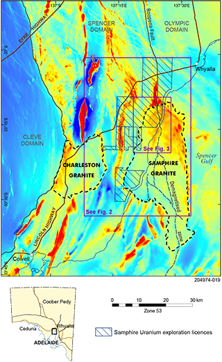
The Hiltaba Suite Samphire granite lies south of Whyalla on the northeastern Eyre Peninsula, underlying the eastern coastal plain and adjacent Spencer Gulf (Fig. 1). Uranium exploration in the area commenced in 2007 and resulted in the discovery of sediment-hosted uranium mineralisation in Eocene paleochannels eroded into the fractionated and uranium-rich Samphire granite.
Exploration has generated datasets from drilling, airborne magnetics, airborne electromagnetics (AEM) and gravity surveys over the onshore part of the Samphire granite. An integration of the available data has enabled the granite intrusion to be subdivided into five generalised geological domains and identified metasedimentary carapaces across the top of the intrusive.
Background
The Samphire granite is known only from mineral exploration drilling and geophysical surveys. In the 1980s BHP explored for lignite along the western margin of the Pirie Basin, finding extensive Eocene Kanaka beds sediment on a metasediment/granite basement; one radiometric profile had a possible ‘redox’ signature (Hole PP-15, BHP Minerals 1982, p. 37). In 2006 UraniumSA Limited, an ASX listed junior exploration company, modelled the Kanaka beds in the Samphire area as permissive for fluid circulation and the development of redox systems, and postulated the underlying circular aeromagnetic anomaly as a potentially uranium-endowed Hiltaba Suite granite. The first exploration hole in 2007 intersected a typical redox profile leading to the discovery of the Blackbush deposit and the geologically similar Plumbush deposit in Eocene Kanaka beds sediment with JORC-compliant resource estimates aggregating 21,100 tonnes U3O8 at a 100 ppm cutoff (UraniumSA 2012, 2013).
Regional setting
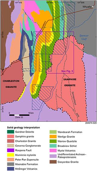
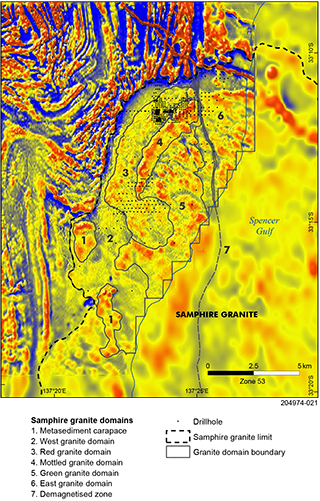
The Samphire granite appears as a north–south elongate, irregular ellipsoidal body ~55 x 23 km (795 km2) in aeromagnetic imagery, delineated by peripheral high-amplitude, positive-linear to curvilinear magnetic responses in Paleoproterozoic country rocks and enclosing fabrics of moderate-low amplitude magnetic response. Country rocks to the intrusion are Warrow Quartzite (c. 2005 Ma; Geoscience Australia, GA, 2017) along the western margin, Broadview Schist (1791–1750 Ma; GA 2017) and Wandearah Formation (1763–1750 Ma; GA 2017) along the northern margin, with undifferentiated Hutchison Group (1964–1850 Ma; GA 2017) interpreted on the eastern and southern margins. The western margin underlies the eastern coastal plain of the Eyre Peninsula, with the remaining portion below the Spencer Gulf (Figs 1, 2). The northwestern onshore portion has been divided into the five granite domains that are the focus of this paper (Fig. 3).
The Samphire granite has been dated at c. 1585 Ma (Jagodzinski and Reid 2017) and forms part of the Hiltaba Suite lying on the boundary between the Spencer and Olympic domains in the southern Gawler Craton (Fig. 1; Ferris, Schwarz and Heithersay 2002). The Roopena Fault Zone, which is interpreted as the Spencer–Olympic domain boundary, extends north from the Samphire granite with a linear demagnetised zone (DMZ) extending south through the intrusion (Fig. 3).
Methodology
Datasets used in the study comprise exploration drilling data (791 holes, 9 with diamond core), aeromagnetics (25 m to 200 m line separation), AEM (500 m to 1,000 m line separation), and gravity surveys (25 m to 200 m station separation). A descriptive ‘domain’ designation has been adopted in the interpretation to reflect the heterogeneity inherent in the geology and accommodate the disconnect between point observations and kilometre-scale geophysical datasets and derived grid surfaces.
In the regional interpretation, geological domain boundaries were constructed on magnetic amplitude/frequency signatures constrained by mapped outcrop. Within the Samphire granite geological domain boundaries were constructed on magnetic amplitude/frequency signatures cross-collated with AEM and gravity responses with geological input from drillhole lithology. Geochemical data was interrogated on the basis of the interpreted domain boundaries (Fig. 3).
Clay alteration
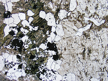
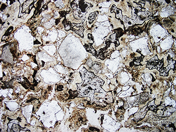
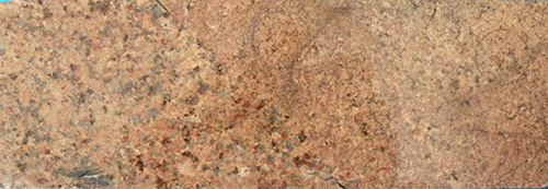
Exploration rotary mud drilling targeted the prospective uranium mineralised Kanaka beds and holes were terminated either in recognisable pre-Eocene basement or at bit refusal. Petrology of end-of-hole (EOH) samples, called clay-altered granite in the field, range from variably friable clearly recognisable granite with incipient to extensive sericite, clay and chlorite alteration (Fig. 4), through to materials comprising angular quartz grains in a groundmass of kaolinite–illite with ghost granitic fabric (Fig. 5).
The origin of the clay alteration is not conclusively established. In regional exploration drilling, significant clay-alteration of basement below the Eocene unconformity was recognised only within the boundaries of the Samphire granite. At the Blackbush deposit, solid 3D models show envelopes of clay alteration extend down into the granite within corridors formed by post-emplacement structures in granite. A pan concentrate of radiometrically active clay-altered material from drillhole MRC167 north of Blackbush contained primary bassanite pseudomorphically replaced by a metamict-altered monazite, potentially during a saline hydrothermal/epithermal alteration (Pontifex 2012).
The pervasive clay-alteration was initially assumed to be a pre-Eocene saprolite. However, given it is restricted to the Samphire granite it is now considered most likely to be an intrusion or post-emplacement-related hydrothermal event.
Figure 4 Photomicrograph of incipient clay-alteration, Samphire granite, MRC007A. Weakly altered granite of dusted K-feldspar accessory biotite, magnetite, ilmenite, apatite and zircon with sericite and clay/chlorite alteration (Purvis 2011). Sample is from 73 m below Eocene unconformity. The hole drilled 55 m of clay-altered granite to bit refusal, then a further 18 m in increasingly competent granite. (Photo 416221)
Figure 5 Photomicrograph of advanced clay-alteration, Samphire granite, MRM1023. Angular quartz in a mass of decussate microcrystalline kaolinite–illite with colloform bands of limonite and sparse microcrystalline carbonate (Purvis 2011). Sample is from 6 m below the Miocene unconformity, no Eocene. (Photo 416222)
The Samphire granite
The Samphire granite has an internal magnetic morphology subdividing it into:
- a southern portion comprising two-thirds of the area (522 km2) and distinguished by linear-textured low amplitude/frequency responses
- a northern portion comprising one-third (243 km2) of the area and distinguished by curvilinear-textured moderate amplitude/frequency magnetic responses.
The two portions are in contact along an indistinct northwest trend discernible in amplitude/frequency textures and indistinct terminations. The northern portion has been subdivided into five granite domains and is overlain by an incompletely preserved carapace of altered metasediments.
Granite margins
On the western margin of the Samphire granite, geophysical profile inflexions are coincident with a change from granite to metasediment in drill samples indicating a near-vertical attitude for the intrusive contact with Warrow Quartzite below Eocene cover. Subtle geophysical variations in the country rock west of the contact are indicative of post-emplacement metasomatic alteration.
North of the margin of the Samphire granite, Broadview Schist and Wandearah Formation country rocks exhibit a moderate- to high-amplitude magnetic anomalism which steadily diminishes northwards along strike. In this area EOH samples from exploration rotary mud holes frequently return anomalous Cu–Co values.
The metasomatic alteration and geochemical anomalism of country rock along the Samphire granite margins is interpreted to be the result of thermal gradients and fluid flow more or less contemporaneous with emplacement.
Metasediment carapace
Inside the northern margin of the Samphire granite clay-altered material is sporadically recognised as a subhorizontal layer below Eocene cover and overlying clay-altered granite. Drill cuttings comprise pink, red, brown, grey variegated silt/clay materials, with minor erratic angular lithic fragments with siliceous–quartzitic or gneissic textures, and are commonly Cu–Co anomalous. The materials are interpreted as the eroded remnants of a concave-south carapace of clay-altered Wandearah Formation and Broadview Schist overlying Samphire granite. They are thin and apparently discontinuous and are not shown in Fig. 3.
In the more sparsely drilled southwestern part of the Samphire granite within the study area, two areas of clay-altered metasedimentary rock are associated with diffuse magnetic responses. These are interpreted as probable roof pendants of country rock overlying stock-like phases of the Samphire granite (labelled 1 in Fig. 3).
Granite domains
Only the northwestern, onshore, portion of the Samphire granite where there is adequate exploration data is considered in this interpretation (Fig. 3). Integration of geological, geochemical and geophysical data has enabled five granite domains to be recognised and interpretation of geophysical imaging has been used to trace discordant relationships and infer an intrusive sequence:
- east granite domain
- green granite domain
- mottled granite domain
- red granite domain
- west granite domain.
East granite domain
The east granite domain extends over 16 km2 and is inferred with less confidence over an area of 189 km2. The domain is characterised as a unit by moderate-high amplitude magnetics which show an internal domal northwest-elongate, low-frequency fabric.
The east granite was intersected in 62 rotary mud holes with drill cuttings comprising light-grey and grey clay/silt with dispersed angular quartz. Gneissic textured fragments in cuttings may represent entrained country rock or xenoliths. There are no core samples.
Green granite domain
The green granite domain extends over 39 km2 and is characterised as a unit by moderate-high amplitude magnetics which show an internal open northwest-oriented ellipsoidal fabric which occurs at a higher frequency than in the east granite domain. From geophysical imaging the domain is interpreted lying west of the east granite, extending along the eastern margin of the mottled granite, terminating to the north against the DMZ, and in the south partially enclosing a lobate portion of the red granite (Fig. 3).
Across the green granite domain Eocene sediments pinch out and the Miocene section thins significantly. The area is interpreted as a paleotopographic high, potentially replicating a domal feature in the upper surface of the Samphire granite.
Green granite was intersected in 23 rotary mud holes with drill cuttings comprising cream, grey and off-white clay/silt with dispersed angular quartz. Petrology from core hole MRC005 describes a coarse- to medium-grained granite composed of coarse K-feldspar crystals intergrown with medium-grained quartz and sericite-altered plagioclase, and lesser biotite with trace zircon and apatite (Jagodzinski and Reid 2017). In hand specimen the granite is visually similar to the mottled granite, though with less apparent sericite alteration.
Mottled granite domain
The mottled granite domain extends over 5.6 km2 and is characterised as a unit by high amplitude/frequency magnetics with a coherent internal linear northeast- to southwest-trending texture and an overprint of linear northwest-trending cross features. From geophysical imaging it is interpreted west of the green granite, extending along the eastern margin of the red granite, terminating to the northeast against the DMZ, and to the southwest thinning and terminating against a lobate feature of the red granite which is partially enclosed by the green granite (Fig. 3).
Mottled granite was intersected in 109 rotary mud holes with drill cuttings comprising cream, grey, off-white clay/silt with dispersed angular quartz. In hand sample granite intersected in MRC007A is green and white mottled, coarse to medium grained and visually dominated by coarse K-feldspar crystals intergrown with medium-grained quartz, plagioclase and lesser dark brown biotite. It is variably sericite altered, particularly the plagioclase.
Red granite domain
The red granite domain extends over 16 km2 and comprises a coherent unit of north-northeast striking, concave-east low-moderate amplitude/frequency magnetics with a subtle overprint of northwest-trending cross features. The domain is interpreted in geophysical imaging extending along the eastern margin of the west granite domain, with a lobate body terminating the southern end of the mottled granite domain and a lobate portion surrounded by the green granite domain (Fig. 3).
Red granite was intersected in 336 rotary mud holes with drill cuttings comprising cream, grey and off-white and occasionally pinkish clay/silt with dispersed angular quartz. Drill core of the red granite is available from nine drillholes; eight of which were drilled in a restricted ~150 m diameter area underlying the Blackbush deposit.
Petrology from core hole MRC009 drilled on the southern edge of the Blackbush deposit describes red-coloured medium-grained granite composed of approximately equal proportions of quartz- and sericite-altered and hematite-dusted plagioclase with lesser K-feldspar, minor biotite, zircon and opaques which may be magnetite (Jagodzinski and Reid 2017).
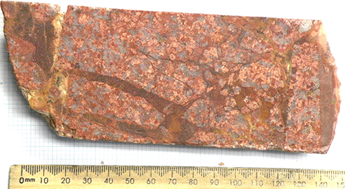
Cored tails from below the body of the Blackbush deposit and ~500 m north of MRC009 intersected similar granites but with micro- and macro-scale differences. Petrology identified a range of rare earth element (REE) minerals associated with finely hematite altered granite. Synchysite is a common accessory in association with fluorite, acicular bastnasite is often included in synchysite, and monazite is uncommon. In isolated sections of some core K-feldspar is displaced by up to 30% fluorite in a medium-grained evenly textured rock. In the majority of cored tails, subtly different granite textures/compositions are juxtaposed either side of fine linear to curvilinear fractures and veins, commonly with chlorite–hematite selvedge, occasionally quartz–hematite or rarely quartz–fluorite. Core in MRM893 intersected subvertical, centimetre-wide fluorite–quartz–hematite veins with colloform or crustiform laminar banding and ‘dog tooth’ crystal forms which are characteristic of epithermal systems (Goldsmith 2014). The juxtaposition of rock type and vein textures are interpreted to reflect block brecciation of the red granite, probably by hydraulic fracturing along zones para-conformable to shallow east-dipping fabrics in the granite (Fig. 6).
Figure 6 Breccia and fracture vein textures, Samphire granite, red granite domain. Top: MRM762, 114.57–114.72 m. Bottom: MRM843, 138.14–138.22 m. (Photos 416223, 416224)
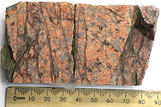
In drill core from the red granite domain a textural fabric dips ~45°; there is no strike orientation (Fig. 7). Downhole radiometric profiles from drillholes across the Samphire granite frequently show stepped profiles indicative of compositional banding across widths of a few to over 10 m. At the granite domain level, interpretation of magnetic profiles indicates the contact between the red and green granite domains has an overall easterly dip ~45° with a northeasterly strike.
Figure 7 Textural banding ~45° to core axis, Samphire granite, red granite domain. MRC009, PQ core, unoriented. (Photo 416225)
The red granite domain is interpreted to have been emplaced as a series of northeast-trending east-dipping phases which, in the area of the Blackbush deposit, are block-brecciated and hydrothermally veined.
West granite domain
The west granite domain extends over 29 km2 and comprises a coherent arcuate north-northeast-trending, concave-east unit of relatively low-amplitude, low-frequency magnetic and gravity signatures which extend parallel with the western margin of the Samphire granite. In geophysical imaging a lobate portion of the west granite domain extends south along the indistinctly defined contact between the northern and the southern portions of the Samphire granite. The west granite is intruded into Warrow Quartzite to the west and is interpreted in contact with the red granite domain to the east, terminating to the northeast against the DMZ (Fig. 3).
The west granite was intersected in 41 rotary mud holes with drill cuttings comprising pink, off-white, cream and grey clay/silt with dispersed angular quartz. There are no core samples.
Geochemical data
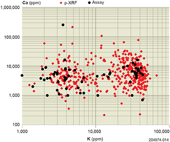
Figure 8 K vs Ca scatter plot, Samphire granite domains. Comparison of assay and p-XRF. p-XRF chip-tray data overlaps sample assay data across the range of heterogeneous clay-altered granite materials.
Exploration rotary mud drilling was sampled at 2 m intervals with the gravity-settled portion of drilling mud return flow collected. An archetype of each interval was grab-sampled into chip trays and the entire EOH sample retained for assay. A total of 134 rotary mud EOH samples were laboratory assayed from four of the five granite domains (Australian Laboratory Services Pty Ltd, ME-ICP61, ME-MS62S). Subsequently, portable X-ray fluorescence (p-XRF) readings were taken on the EOH chip-tray compartment from drillholes without assays (503 holes). While p-XRF instrumentation has acceptable precision within recognised limits, in this application the physical inhomogeneity of the material in the chip trays and the instrument’s small field of view resulted in a relatively low reproducibility.
At a whole-of-population level and across the range of values, the distribution of K and Ca assay data overlaps the p-XRF chip-tray data. This similarity of distribution of values indicates that for the purpose of the present work the methods are comparable, and that patterns and trends in values most probably reflect variability in the geology/geochemistry of the granite domain materials (Fig. 8).
Geochemical trends
The assay and p-XRF data are grouped together, subset by granite domains and treated as populations rather than individual values. While there is a high variability of individual values forming significant noise envelopes for each domain, at a population level there are interpretable patterns within the data.
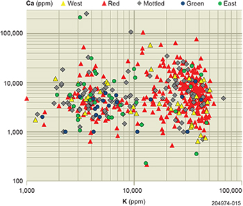
A scatter plot of K vs Ca data by granite domain indicates bi-modal populations with the east, green, mottled and red granite domains showing high and low K subsets either side of 10,000 ppm, with significant overlap between the domains. Visually, the east and green granite domain data plot predominantly below the 10,000 ppm K level, the red granite domain data plot predominantly above that level, and the mottled domain values appear more evenly spread. The west granite domain exhibits a relatively even spread of K values with a possible bi-modal tendency to a high/low Ca spread (Fig. 9).
Trends within the noise envelopes are more readily discernible when domains are represented by their average values (Table 1). The limitations of this approach are obvious given the uncertainties inherent in the geochemical datasets and the interpretive limitation of the geological domains. As a general proposition, increases in K, Rb/Sr and U/Th ratios are indicators of fractionation, though ion substitution for K in crystal lattices is a significant constraint on interpreting Rb/Sr ratios in isolation (Table 2).
Table 1 Geochemical values, Samphire granite domain
| Domain | Ca (ppm) | K (ppm) | U (ppm) | Th (ppm) | Rb (ppm) | Sr (ppm) | n | ||
|---|---|---|---|---|---|---|---|---|---|
| Average | Range | Average | Range | Average | Average | Average | Average | ||
| West | 7,084 | 857–58,659 | 21,575 | 1,853–50,487 | 25 | 76 | 266 | 24 | 38 |
| Red | 8,652 | 531–106,510 | 25,664 | 1,449–49,830 | 44 | 62 | 335 | 28 | 324 |
| Mottled | 9,327 | 991–254,000 | 15,147 | 1,258–67,471 | 22 | 49 | 128 | 36 | 105 |
| Green | 3,783 | 1,000–10,599 | 11,039 | 1,400–41,878 | 15 | 73 | 110 | 34 | 22 |
| East | 12,697 | 228–213,691 | 11,322 | 1,000–47,044 | 17 | 50 | 129 | 43 | 61 |
Table 2 Fractionation indicators, Samphire granite domain
| Domain | Rounded average | |||
|---|---|---|---|---|
| K (ppm) | U (ppm) | Rb/Sr | U/Th | |
| West | 22,000 | 25 | 11.0 | 0.49 |
| Red | 26,000 | 44 | 12.1 | 0.90 |
| Mottled | 15,000 | 22 | 3.6 | 0.59 |
| Green | 11,000 | 15 | 3.7 | 0.21 |
| East | 11,000 | 17 | 3.7 | 0.58 |
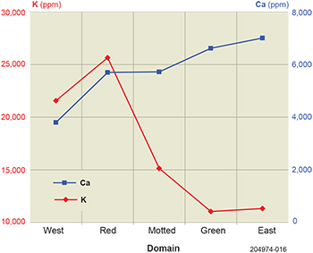
Line plots of average values of the domains show systematic changes indicative of increasing fractionation from the east through to the west granite domain. Average K is similar for both the east and green domains, increasing for the mottled before peaking for the red and declining somewhat for the west granite domain. There is a reverse trend for average Ca which is at a high in the east and declines through the green, mottled and red to a low in the west granite domain (Fig. 10).
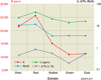
Line plots of domain average values for U ppm, U/Th and Rb/Sr show a similar pattern as K average values. The consistencies of trends in the rock-forming metals and in ratios indicative of fractionation are consistent with the inferred sequential emplacement from east to west of domains of increasingly fractionated granite (Fig. 11).
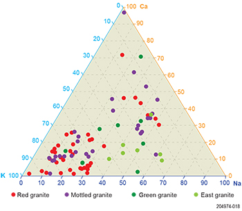
Ternary plots of normalised K:Ca:Na have been compiled from assay data available for four of the five granite domains; there is no Na data for the west granite domain. Trends which are apparent in the line and scatter plot data from the east granite domain through the red granite domain are exhibited in the Ternary plots. Where there is sufficient data, notably for the red and mottled granite domains, the tendency for bi-modal populations seen in the scatter plot of all K vs Ca data remains apparent (Fig. 12).
Across the Samphire granite within the east, green and west granite domains, the drillholes with high K values are randomly distributed without any apparent underlying geological control. Within the area of the red granite domain, the distribution of high K values is biased by the concentration of drilling at the Blackbush deposit.
Discussion
Geological and geochemical data generated during uranium exploration has been used to interpret the geology and emplacement history of the Samphire granite. The area is overlain by a relatively consistent 50–80 m of Eocene, Miocene and younger sedimentary rocks and the following discussion is of the geology below the Eocene unconformity, or the Miocene unconformity where Eocene is absent.
The Hiltaba Suite Samphire granite was intruded into Warrow Quartzite, Broadview Schist, Wandearah Formation and undifferentiated Hutchison Group metasedimentary country rocks. The outer western contact is essentially subvertical while the upper Samphire granite surface is gently domed with a partially preserved shallow-dipping metasediment carapace in the north of the area studied. The vertical outer contacts and domal top enclose five incompletely concentric, subvertical to easterly dipping granite domains. Relationships interpreted from geophysical imaging and geochemical trends indicate a sequential east-to-west emplacement of increasingly fractionated domains of granitic materials.
Along the outer margins of the Samphire granite, metasomatic alteration of country rock is magnetic-positive and in the geochemically reactive Wandearah Formation it is associated with hematite alteration and Cu–Co anomalism. The alteration and mineralisation is interpreted to be the result of thermal gradients and fluid flow contemporaneous with emplacement.
Across the upper surface of the intrusion both the granite and overlying carapace are clay-altered with sporadic Cu–Co anomalism associated with the metasediments. Clay-alteration and mineralisation is interpreted to post-date granite emplacement and magnetic-positive metasomatic alteration.
In parts of the Samphire granite where the metasediment carapace has been removed, clay-alteration of the granite is associated with linear northeast- and northwest-trending structures which are interpreted to post-date lithification. In the Blackbush area 3D models show envelopes of clay-alteration extend 80–100 m below the top of granite within a north-trending fault-bounded corridor.
The five granite domains comprising the northern portion of the Samphire granite are each delineated by coherent geophysical signatures, but are internally heterogeneous with geochemical and geological variability.
East granite domain material is typically more sodic and less potassic than all other domains and has the lowest Rb/Sr and U/Th ratios and U geochemistry. Gneissic/banded materials in drill cuttings may be unidentified carapace, roof-pendant remnants or protolith xenoliths.
Green granite domain material is similar to the east granite domain with broadly comparable sodium, potassium and Rb/Sr, U/Th ratios and U geochemistry, but with its own distinct geophysical signature. To the south and west, the green granite domain is intruded by the red granite domain.
Mottled granite domain material is less sodic and more potassic than the east and green granite domains, transitional to those of the west and red granite domains. Its Rb/Sr, U/Th ratios and U geochemistry overlap the other domains, tending to be lower than the west and red granite domain materials and higher that the green and east granite domain populations. The mottled granite domain is intruded by the red granite domain.
The east, green and mottled granite domains comprise a sequence of fractionation and emplacement. On the basis of interpreted contact relationships and geochemical trends, the east granite domain is the least fractionated and the first emplaced. The interpreted contact relationship and geochemistry of the conspicuously linearly textured mottled granite domain suggest it was the most fractionated and last of the east–green–mottled series to be emplaced.
Red granite domain material shows a step change in geochemical trends being less sodic and significantly more potassic with significantly higher Rb/Sr and U/Th ratios and U geochemistry than the mottled, green and east domains. At its north end the red granite domain has a linear east-dipping contact with the mottled granite domain. To the south the red granite domain intrudes the east–green–mottled series, terminating the extent of the mottled granite and forming a semi-circular lobe within the green granite domain.
Block brecciation and hydrothermal veining of the red granite is associated with alteration and elevated U-REE mineralisation in the area of the Blackbush deposit.
West granite domain material is similar to the red granite domain with comparable potassium values but with lower calcium; there is no sodium data available. The domain has Rb/Sr, U/Th ratios and U geochemistry which is lower than the red but higher than the mottled, green and east granite domains. The west granite domain is emplaced between the red granite and country rock to the west. To the south it is in contact with the southern portion of the Samphire granite along an indistinct northwest trend.
Carapace of altered country rock is present over the northern margins of the Samphire granite intrusion. Two isolated areas of clay-altered country rock in the south of the west granite domain on the western margin of the Samphire granite are interpreted as intact carapace overlying stocks of the Samphire granite.
The uranium-mineralised Eocene fluvial channel which hosts the Blackbush deposit eroded through the shallow-dipping carapace and incised into underlying clay-altered uranium-rich red granite domain materials.
Conclusion
The Samphire granite is a fractionated Hiltaba Suite intrusion with an areally larger southern portion and a smaller northern portion. Within the onshore part of the northern portion, five increasingly fractionated granite domains are interpreted to have been sequentially emplaced in the form of an inverted cone-like body. The least fractionated east granite domain is close to the centre with sequentially more fractionated green and the east-dipping mottled and red domains westwards. The west granite domain has vertical country rock contacts.
Country rock metasomatic alteration contemporaneous with emplacement of the Samphire granite is associated with base metal anomalism. Clay-alteration extends across the top of the Samphire granite and remnants of clay-altered metasediment carapace are metal anomalous. In the Blackbush area there is a localised zone of more intense alteration with U-REE mineralisation associated block brecciation, epithermal veining and clay-alteration of the uranium-rich red granite domain.
Acknowledgements
Samphire Uranium Pty Ltd, the owners of the Samphire project, provided access to the data. Our concepts are built on the contributions of the geoscientists who worked on the project, in particular Edward Keys, Wade Bollenhagen, Nicole Galloway-Warland, Marco Scardigno and Faith Gerhard. The data and intellectual contributions of Nigel Cook at the University of Adelaide and his students Sam Goldsmith and Urs Domnick have been invaluable. Stacey McAvaney and Mark Pawley (Geological Survey of South Australia) ensured logical rigor.
References
BHP Minerals 1982. Exploration Licence 766, Mullaquana, South Australia, Report for the quarter ended 8th March, 1982, Open File envelope 04124. Primary Industries and Resources South Australia, Adelaide.
Ferris GM, Schwarz MP and Heithersay P 2002. The geological framework, distribution and controls of Fe-oxide and related alteration, and Cu-Au mineralisation in the Gawler Craton, South Australia, Part I: geological and tectonic framework. In TM Porter ed., Hydrothermal iron oxide copper-gold and related deposits: a global perspective, Vol. 2. Adelaide, PGC Publishing, pp. 9–31.
GA – see Geoscience Australia
Goldsmith S 2014. The Samphire project: a distal IOCG and evidence for Mesoarchean crust in the Gawler Craton. BSc Hons thesis, University of Adelaide.
Pontifex I 2012. Mineralogical Report No. 10193. Pontifex & Associates Pty Ltd report to UraniumSA Limited.
Purvis A 2011. Mineralogical Report No. 9959. Pontifex & Associates Pty Ltd report to UraniumSA Limited.


