
To apply for a lease using the template, applicants must first determine whether their proposed mining operation is considered eligible against a set of criteria.
The criteria have been designed to gauge potential impacts from proposed mining on the existing environment, community and third party infrastructure.
Proposed operations that do not meet the eligibility criteria are considered to have potential impacts that are not easily defined and a mining proposal (MP) must be developed in accordance with Ministerial Determination 003, the Mining Act 1971 and Mining Regulations 2020.
Eligibility criteria
The eligibility criteria are available for completion on the South Australian Resources Information Gateway (SARIG) using the Defined Impact Mining Proposal (MP) eTool.
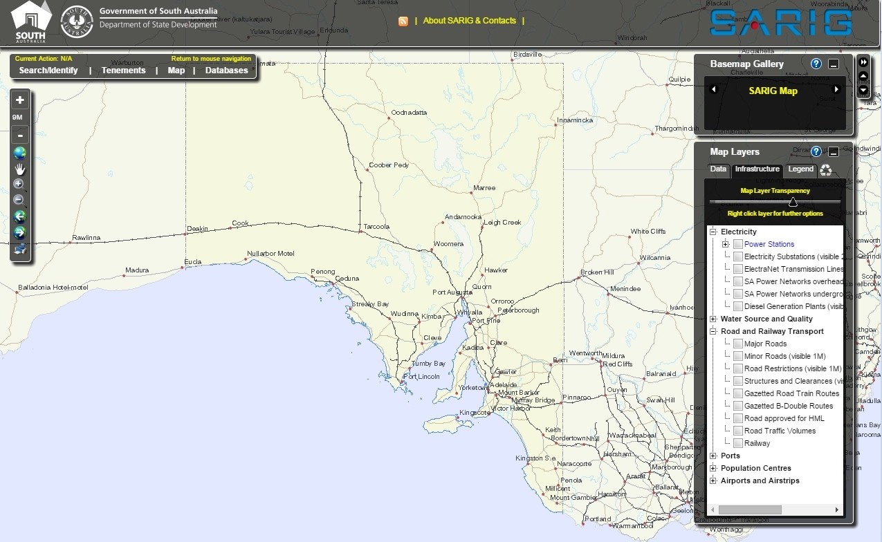
SARIG is a secure online map-based web application that delivers state wide geological and geospatial data. Access to SARIG is free via https://map.sarig.sa.gov.au and no login is required.
Step by step guide
Step 1: Click 'Main Menu' and select Mineral Tenements from the list.
Step 2: Click the 'View' arrow under Mining Tenements. Click 'Start'.
Step 3: Enter the relevant Mineral Claims (MC) number and click Evaluate. SARIG will evaluate whether the MC falls within the eligibility criteria area.
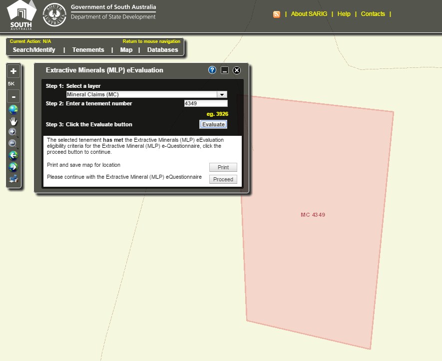
Step 4: Answer yes or no to each question proceeding down the list.
If the criteria are not met you will be notified and re-directed to the relevant Ministerial Determination. If you would like to return to the previous question click the arrow.
Once the criteria have been successfully completed print the page (using the print icon) for inclusion with your application.
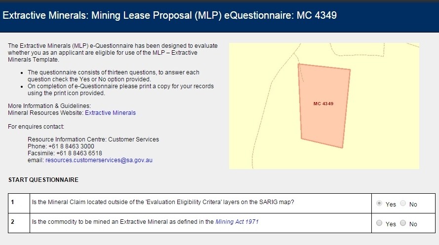
The template can then be accessed for download via the 'Extractive Minerals (MLP) Template'.
The extractive minerals MLP eTool template
Question 1: SARIG evaluation criteria
Within South Australia areas exist where quarrying cannot occur due to land access restrictions, sensitive environmental features or proximity to existing infrastructure. A layer has been developed within SARIG to identify these higher risk areas.
1. Is your mineral claim identified within the following SARIG layers? If so, you are not eligible to apply using the template; a mining proposal must be developed in accordance with Ministerial Determination 003, the Mining Act 1971 and Mining Regulations 2011.
Evaluation criteria layer breakdown |
| PETROLEUM TENEMENTS |
| Petroleum Pipelines & Facilities Ten |
| Petroleum Special Survey Area Ten |
| LAND ACCESS |
| No Exploration or Production Access |
| No Mineral Exploration or Production Access (Parks & Reserves) |
| No Petroleum/Geothermal Exploration or Production Access (Parks & Reserves) |
| Coongie Lakes - No Exploration or Production Access |
| No Exploration or Production (Wilderness Protection Areas) |
| Areas Reserved from the Mining Act 1971 & Opal Act 1995 |
| Maralinga Nuclear Test Sites |
| Special Declared Areas |
| Section 15 Gazettal |
| Restricted Exploration or Production Access |
| Restricted Mineral Exploration or Production Access (Parks & Reserves) |
| Restricted Petroleum/Geothermal Exploration or Production Access (Parks & Reserves) |
| Conservation Reserves |
| Aboriginal Land |
| Woomera Prohibited Area (WPA) |
| Precious Stones Field |
| Other Restricted Land |
| Branched Broomrape |
| Land Use |
| Murray River Water Protection Area |
| Hills Face Zone |
| Native Vegetation Heritage Agreements |
| DRILLHOLES |
| Geothermal Wells |
| Petroleum Wells |
| Geology |
| Geological Monuments |
| TOPOGRAPHIC & CULTURAL |
| Built up areas |
| Waterbodies |
| INFRASTRUCTURE |
| Power stations |
| Gas power station |
| Coal power stations |
| Wind power stations |
| Diesel power stations |
| Biomass power stations |
| Electricity Substation (2M) |
SARIG can also be used to find:
- South Australian mining and petroleum projects
- Geology, geophysics, regolith, paleodrainage, petroleum basins, groundwater and earthquakes
- Mineral, petroleum and geothermal tenement boundaries
- Exploration company details and commodity information
- Infrastructure locations e.g. power stations, substations and transmission lines, water pipelines, roads and railway, ports and airports
- Data from other government agencies that value-add to mineral and energy resources managed data, e.g. land access layers for parks, Native Title and property boundaries
- Seismic lines and seismic horizon maps
- SEG-Y and HyLoggerTM image and data downloads
For more information or assistance using SARIG contact:
Phone: +61 8 8463 3000
Email: DEM.customerservices@sa.gov.au
Question 2: Commodity
2. Is the commodity to be mined an extractive mineral as defined in the Mining Act 1971?
Extractive minerals means sand, gravel, stone, shell, shale or clay, but does not include:(a) any such materials that are mined for a prescribed purpose; or
(b) fire clay, bentonite or kaolin.
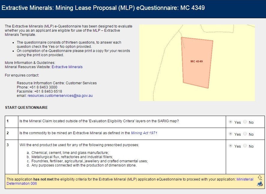
Question 3: Prescribed purpose
3. Will the end product be used for any of the following prescribed purposes:
Extractive minerals are not only defined by what they are but also what they will be used for. The definition of extractive minerals precludes any such minerals that are mined for a prescribed purpose.
Once an extractive mineral is to be used for a prescribed purpose it then becomes an industrial mineral and attracts a different royalty rate. The royalty rate for an extractive mineral is calculated on a monetary amount per tonne while industrial minerals are calculated on a percentage of the value of the mineral.
For example if sand is being mined for glass production the applicant must apply for a mineral lease (ML) and prepare a mining proposal (MP) in accordance with Ministerial Determination 006. The royalty rate will be calculated on a percentage of the value of this sand as its end product.
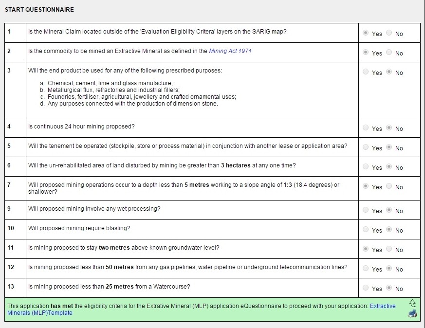
Question 4: Operational hours
4. Is continuous 24 hour mining proposed?
Continuous 24 hour mining refers to mining that does not stop over a 24 hour period.
Mining over a 24 hour period increases the potential for impacts on the local community through noise in the form of both operational activities and truck movements to and from the quarry. For this reason miners that propose a 24 hour continuous operation are deemed of higher risk and must prepare a more detailed MP.
Question 5: Associated tenements
5. Will the tenement be operated (stockpile, store or process material) in conjunction with another lease or application area?
Stockpiling, storing or processing material from another mining area increases the potential for spread of weeds or contamination of soil. It is difficult to quantify what impact importation of foreign material may have on the environment without further investigation. Consequently this activity is considered higher risk and a more detailed MP is required for assessment.
Question 6: Land disturbance
6. Will the un-rehabilitated area of land disturbed by mining be greater than 3 hectares at any one time?
The area of land that is disturbed by mining correlates with a number of potential impact events. Once an area has been stripped of vegetation and topsoil it is much more vulnerable to erosion through wind and water. These erosional activities can result in impacts to the environment and communities in the form of nuisance dust and contaminated surface water runoff. Limiting the disturbed area to three hectares decreases the risk of these impacts.
Applicants that cannot plan mining to occur with a maximum disturbed area of 3 hectares are considered higher risk and must provide a more detailed MP for assessment.
Question 7: Mining depth and slope angle
7. Will proposed mining operations occur to a depth less than 5 metres from ground level working to a slope angle of 1:3 or shallower?
The depth and working batter have been restricted to lessen the risk to health, safety and landform stability associated with deeper mining operations. Actively mining to a batter of 1:3 or less will also significantly reduce expenditure at mine closure as the final slope will already be formed.
Applicants that wish to mine deeper or leave a steeper slope angle are considered higher risk and must provide a more detailed MP for assessment.
Question 8: Mining a sand dune or surface outcrop
8. Will proposed mining be conducted on a sand dune or a surface outcrop less than 10m in height?
The department recognises that not all mining occurs below ground level and this criterion has been included to ensure small scale operators are not excluded if mining these landforms. If done correctly mining of a sand dune or surface rock outcrop is considered to be low risk. The height has been restricted to ten metres as mining any higher than this may create stability issues depending on the geological properties of the particular substrate.
If mining is proposed on a landform that is higher than ten metres a more detailed MP will be required for assessment.
Question 9: Processing
9. Will proposed mining involve any wet processing?
Processing refers to refinement of the raw material to create an end product. For example limestone may be crushed and screened to create the right specification size for use as road base. Wet processing refers to any processing that involves the addition of water or any other liquid. The addition of liquid to processing creates a waste product that could potentially impact on the environment if not managed appropriately.
Because of the higher risk level associated miners that propose wet processing must provide more information in a MP for assessment.
Question 10: Blasting
10. Will proposed mining require blasting?
Miners proposing the use of blasting have been excluded from using the template due to the higher risk of potential impacts associated with these activities. Blasting has the potential to impact on the community through noise and vibration.
Because of the higher risk associated applicants proposing this activity must provide a more detailed MP for assessment.
Question 11: Groundwater
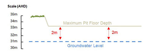
11. Is mining proposed to stay two metres above known groundwater levels?
South Australia is the driest state in Australia and many ecosystems depend on groundwater for survival. In regional areas of the state groundwater is the primary water resource for local communities and any impact to the quantity or quality could directly impact on these people.
To decrease the risk of impacts to groundwater miners using the template are restricted to mining no more than two metres from the groundwater table as shown below.
Mining operators that propose mining into the groundwater table, or less than two metres from it, must provide a more detailed MP for assessment.
The groundwater depth can be determined by:
(a) Consultation with the landowner;
(b) Enquiring water well data on SARIG.
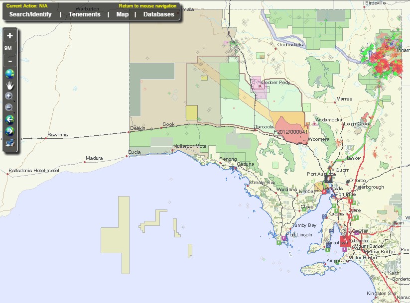
To access the relevant data on SARIG:
- Ensure the layers for mineral claims and water wells are ticked
- Find the mineral claim and look for water wells in the nearby vicinity - they should appear like the bores shown below.
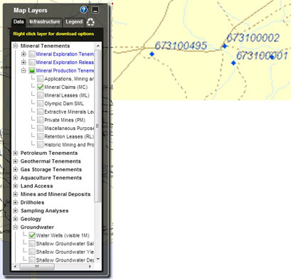
Select the identify option from the drop down menu located in the top left portion of the screen and draw a box over the nearby water wells in the near vicinity.
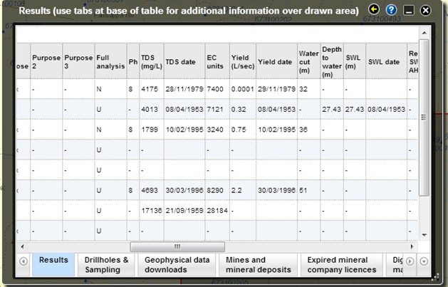
An information box will appear for each water well. Scrolling to the right may find information on the depth of standing water for the respective wells, as shown below - note that not all wells will have this information and in some cases the data is outdated, please check the associated date. Select either the closest well with information or calculate an average of the surrounding wells in the area.
Question 12: Proximity to third party infrastructure
12. Is mining proposed less than 50 metres from any gas pipelines, water pipeline or underground telecommunications lines?
Before mining it is important to establish whether any third party infrastructure is present in the area. Mining into underground infrastructure or too close to above ground infrastructure may cause damage and leave mining operators liable for repair or replacement costs.
The department considers a buffer of fifty metres sufficient to reduce the risk of damage to third party infrastructure. If mining is proposed less than fifty metres from third party infrastructure a more detailed MP will be required for assessment.
The location of third party infrastructure can be sourced from the landowner, local council or telecommunication companies. Infrastructure information can also be accessed via the infrastructure tab on SARIG.
Question 13: Watercourse
13. Is mining proposed less than 25 metres from a watercourse?
A watercourse means any of the following (whether or not temporarily dry):
- river, creek or other body of flowing water
- dam or reservoir that collects water flowing in a watercourse
- lake, wetland or other body of water flowing in a watercourse
- the Coorong
- an artificial channel
- a public stormwater disposal system
- part of a watercourse.
Once an area has been stripped of vegetation and topsoil for mining the risk of erosion and sediment transport through water runoff significantly increases. Sediment laden water can impact on water quality, clog watercourses increasing the changes of flooding, and alter delicate watercourse ecosystems.
The department considers a buffer of 25 metres sufficient to reduce the risk to watercourses from mining given all contaminated water must be retained on site.
If mining is proposed less than 25 metres from a watercourse then further detail will be required in the MP for assessment.
The location of watercourses can be sourced from the landowner or aerial imagery.