
On this page
Woomera Prohibited Area
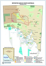
The Woomera Prohibited Area (WPA) covers an area of 122,188 square kilometres approximately 450km NNW of Adelaide. The WPA is a globally unique military testing range and a key asset in Defence capability development. The WPA is also an area of potential economic importance in terms of its natural resources – and some mining is already conducted in the WPA. The Government favours multiple land use in the WPA to the maximum extent possible.
The WPA has been declared a Prohibited Area under Part VII of the Defence Force Regulations and is used for 'the testing of war material' under the control of the Royal Australian Air Force.
In 2011 a joint Australian Government - South Australian Government WPA Coordination Office (WPACO) was established to administer non-Defence use of the WPA, including the develoment of new management framework arrangements that support co-existence between Defence and non-Defence users within the WPA.
In August 2014 the new statutory access regime for new non-Defence users in the WPA came into force with the passage of the Defence Legislation Amendment (Woomera Prohibited Area) Act 2014 by the Australian Parliament. It amends the Defence Act 1903 (Cwth) by inserting Part VIB of the Defence Act and sets out a permit system, the access management zones with defined exclusion periods, new compliance and enforcement measures, compensation, and a process for review of decisions. The administrative details of the new statutory permit system are contained in the WPA Rule 2014.
Note that the new permit system to access the WPA applies to new non-Defence users including resource exploration and mining companies, opal miners, tourists and environmental/research organisations. Existing miners, pastoralists, Aboriginal persons and traditional owners are defined as existing users whose access will continue to be governed by the Defence Regulations 2016.
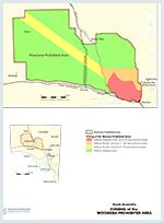
Under new management framework arrangements within the WPA, Defence remains the primary user of the area. The WPA has been divided into Green, Amber and Red access zones, each offering different levels of access or time share to non-Defence users.
A detailed map, including licence overlays and GIS data is available from the South Australian Resources Information Geoserver (SARIG).
Non-Defence users may be required to evacuate up to an annual cap of 56 days, in blocks of 7 days duration. Non-Defence users may not need to be evacuated during the course of the year, depending on the frequency and type of testing being conducted in the Green access zone.
Users who are resident in the WPA will be given a minimum of 6 months notice of any evacuation periods. Users who do not have a permanent presence in the WPA will be given no less than 14 days notice.
Non-Defence users may be required to evacuate the Amber access zone completely, in blocks of 7 days duration, for 140 days per year in the south-eastern area of the WPA (Defence Periodic User Zone 1) and 70 days per year in the corridor (Defence Periodic User Zone 2). Complete evacuation means no non-defence personnel and activity on the site.
Non-Defence users in the Amber access zone will be notified of the evacuation windows for the coming financial year every March. This is to assist commercial planning by providing a clear indication of when non-Defence users will and will not be able to access the WPA.
The frequency of Defence use of the Red access zone, the associated safety and security requirements, and the complexity of managing use, means that no additional non-Defence users will be admitted to the Red access zone.
The one exception will be geological survey conducted by the South Australian Government in collaboration with Commonwealth government agencies.
Public right of access
Separate to the Green, Amber and Red access zones, the Defence Minister unde rthe WPA Rule has granted a standing permission for people to access the Central Australian railway line, the Stuart Highway, the William Creek to Coober Pedy Road, the Lake Cadibarrawirracanna Road (also known as Public Acess Route 18), the Olympic Dam Highway (B97) and Woomera Village. The Defence Minister may however suspend the standing perission over the access routes and close the temporarilty when required for the resting of war material.
Exclusion periods
The Amber Zone exclusion periods are published in March of each year showing the access restrictions which apply during the following financial year (ie 1 July to 30 June).
Restrictions that may take place in parts of the Green Zone are notified at least 6 months in advance for resource production permits holders and a minimum of 21 days prior to the activity for all other users.
More information about the current exclusions periods can be found at: www.Defence.gov.au
Procedure for entry into the WPA
Access to the WPA for exploration and mining is governed by a permit issued by the Woomera Prohibited Area Coordination Office (WPACO)
Companies seeking access for exploration activities to the WPA must:
- Hold a licence or lease issued by the South Australian Department for Energy and Mining.
- Obtain a Resource Exploration Access Permit (Form W001) or Resource Production Access (Mining) Permit (Form W002).
- Ensure that all persons entering the WPA under the permit hold an Approved Person Status (Form W003) or are an Escorted Person (W004).
- Request access permission for each instance of access to the WPA using the Access Form (W007).
Applicable forms can be downloaded from Woomera Prohibited Area Coordination Office (WPACO)
Co-existence arrangements
The Woomera Prohibited Area Advisory Board monitors and reports on the balance of national security and economic interests in the WPA, oversees the implementation of the co-existence policy arrangements and fosters strategic relationships between Defence and non-Defence users of the WPA.
A Memorandum of Understanding regarding Woomera Prohibited Area Co-existence Arrangements is now available. For further information on management arrangements visit Woomera Prohibited Area.
Woomera Restricted Airspace (WRX)
The WRX layer available from the South Australian Resources Information Gateway shows the restricted airspace above the Woomera Prohibited Area (WPA) and forms part of the RAAF Woomera Test Range (WTR). The layer is a helpful tool when planning to conduct airborne surveys and other airspae-related activities over the WPA.
The layer is divided into individual restricted areas (blocks). One or a combination of restricted areas can be activiated (ie airspace above that portion of the WPA becomes restricted) when testing of war material is taking place during an exclusion period.
For more information about the WRX contact WTR on +61 8 8674 3370.
For more information, contact:
-
Woomera Prohibited Area Coordination Office
Phone: 1300 727 420
International: +612 6265 4448
Fax: (02) 6265 5878
Email: WPACO@defence.gov.au
Address:
WPA Coordination Office
Department of Defence
PO Box 7901
Canberra ACT 2610 -
Woomera Test Range Operations Office
Phone: 08 8674 3370
International: +618 8674 3370
Fax: (08) 8674 3217
Email: woomera.enquiries@defence.gov.au
Address:
Woomera Test Range
PO Box 157
Wommera SA 5720