
Otway Basin Petroleum Systems Model 2023
Aim
The aim of this project was to generate new datasets and new exploration concepts to stimulate the next phase of gas exploration in the onshore Otway Basin to supply South Australian customers. Outputs from the project also provide insights into the potential for Carbon Capture and Storage and underground hydrogen storage in the basin.
Introduction
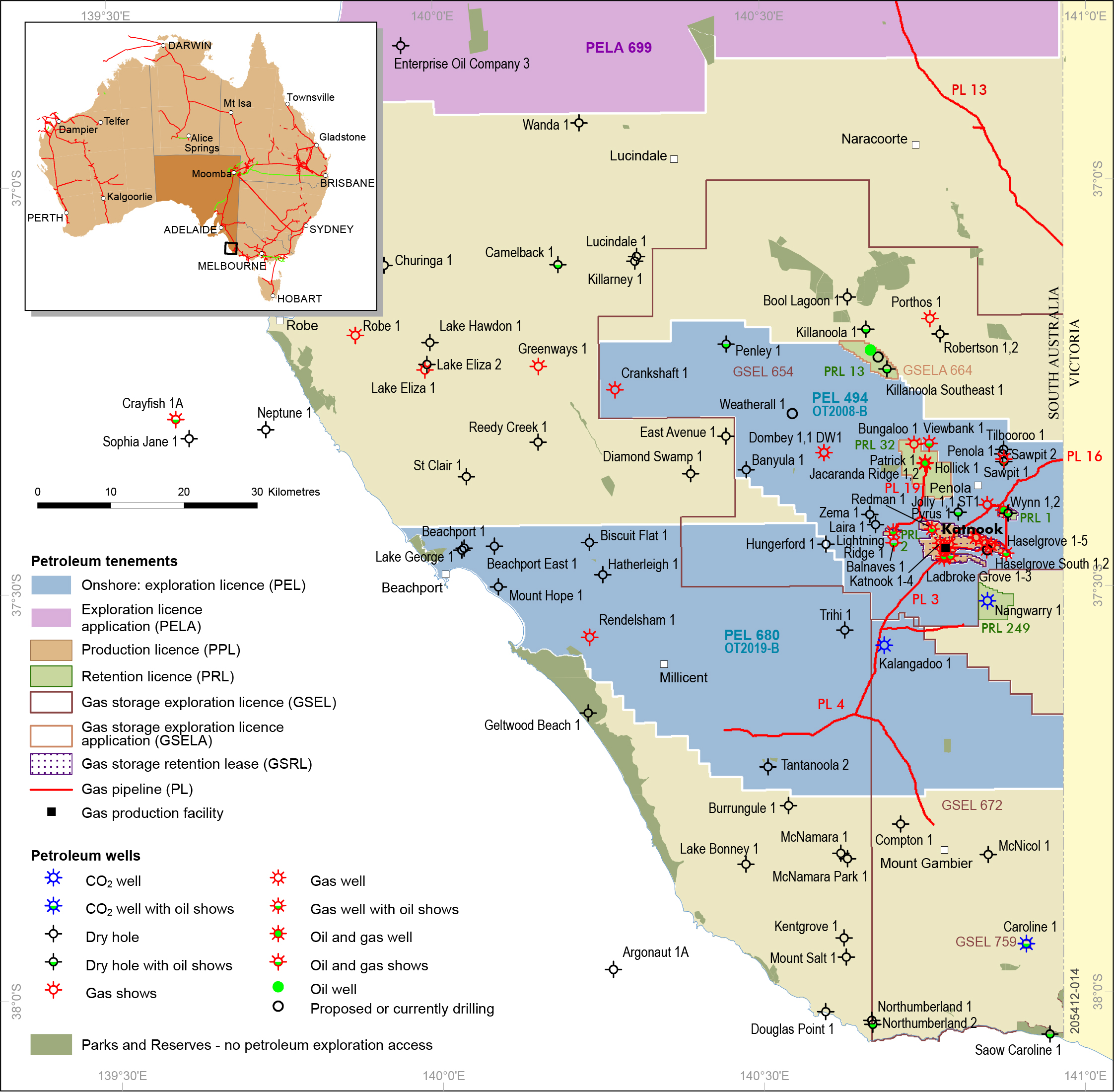
The Otway Basin is one of the best known Mesozoic rift basins that span the southern coastline of Australia and has both on and offshore gas production and oil discoveries (Fig. 1). 104 petroleum and 6 geothermal wells have drilled since the 1890s. In 1987 Katnook 1 discovered economic gas in the Penola Trough (the most significant hydrocarbon province in the SA part of the basin to date), further drilling led to more discoveries and construction of a processing plant. The modern Katnook Gas Plant (currently mothballed) has improved the economic viability of small gas discoveries to fuel both local gas markets and electricity generation. The SA Otway Basin is strategically connected to local southeast and Statewide natural gas customers by the SEA Gas and SESA pipelines (Fig. 1).
Outcome
Petroleum system modelling (PSM), based on extensive, source rock, well and seismic investigation, shows, for the first time, significant oil and gas generation and expulsion in the lightly explored Robe and Tantanoola Troughs (Fig 2).
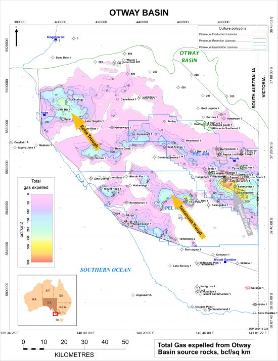
Figure 2. Modelled gas expulsion map onshore Otway Basin in South Australia (JPG 10 MB)
Product downloads
Project summary
Core
Cubitt C and Tiainen S 2025. Conventional core interpretation, onshore Otway Basin, South Australia. Report Book 2025/00016. Department for Energy and Mining, South Australia, Adelaide
View metadata and download core package
What's included:
- Core Logs (Excel)
- Core Logs (Plots)
DE-GDE
View metadata and download DE-GDE package
What's included:
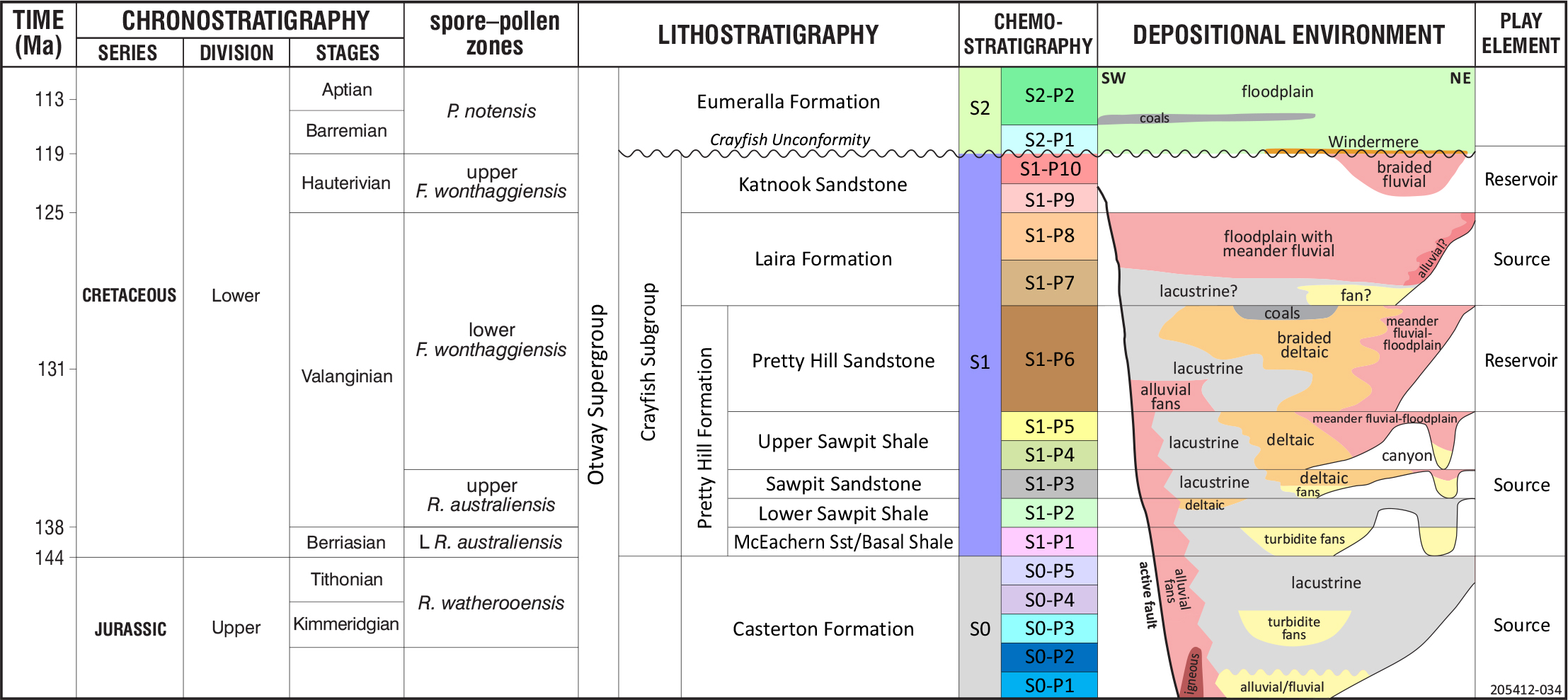
- Depositional environment and gross depositional environment diagrams and maps (JPG and PDF)
Source rock geochemistry
View metadata and download source rock geochemistry package
What's included:
- 1D Modelling
- Model exports
- Petrosys maps
- Source rock logs
- T3 Modelling (Trinity project)
Mapping projects
Seismic
Kirk R 2024. Seismic stratigraphy of the Jurassic – Early Cretaceous sequences of the onshore Otway
Basin, South Australia. Report Book 2024/00018. Department for Energy and Mining, South Australia, Adelaide
View metadata and download seismic package
What's included:
- Two-way time grids
- Depth grids
- Isopachs (for GDE mapping)
- Difference maps
- Extent polygons (.shp)
Stratigraphy
Publications
Bendall, B., Forbes, A.B., Revie, D.C., Eid, R.C., Herley, C. and Hill, A.J., 2020, New insights into the stratigraphy of the Otway Basin. The APPEA Journal 60(2) 691-696
Bendall, B., Forbes, A. and Hill, A.J. 2021. Resolving lithostratigraphic complexities in the Crayfish Group, Otway Basin using chemostratigraphy. The APPEA Journal 61(2) 588-593
Cubitt C, Kirk R, Rady T and Tiainen S, 2024. Gross depositional environment mapping in the onshore South Australian Otway Basin: an example of data integration. Australian Energy Producers Journal 64(S1), S347–S353.
Edwards C, Rady T, Cubitt C, Kirk R and Tiainen S, 2024. Petroleum Systems Analysis of the Onshore Otway Basin, South Australia. Australian Energy Producers Journal 64(S1), S359–S364
Hill, A.J., Bendall, B. and Murray, A. 2020, New insights into the organic geochemistry of the Otway Basin. The APPEA Journal 60(2) 712-717
Tiainen S, Kirk R, Cubitt C and Rady T, 2025. Revisiting the rocks discovers turbidites and a new exploration play in the Penola Trough, Otway Basin, South Australia. Australian Energy Producers Journal 64(S1), S435–S440.
For more information please contact us at DEM.Petroleum@sa.gov.au.