
Page last updated March 2026
On this page
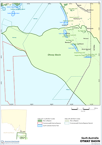
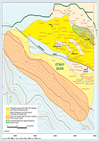
The Otway Basin is a Jurassic - Late Cretaceous basin.
The Otway Basin comprises one of a series of Jurassic to Cretaceous basins with a Tertiary cover (Gambier Basin) that occur along the southern coast of Australia.
For information on Otway Basin structural and tectonic history, new seismic mapping, litho- and biostratigraphy, source rocks and maturity, reservoirs, seals, trap development, discovered reserves, field reviews, undiscovered potential, exploration history, infrastructure, economics and land access considerations see the Petroleum geology of South Australia. Volume 1: Otway Basin (Second edition).
Onshore Otway Basin plays
- Location
- Geological Setting
- Windermere Sandstone play
- Laira Formation play
- Pretty Hill Sandstone play
- Upper Sawpit Shale play
- Sawpit Sandstone play
- Lower Sawpit Shale play
- Casterton Formation play
- Fractured Basement play
Downloads
- View metadata and download the Petrosys mapping files for the onshore Otway Basin play analysis
Related reports and presentations
- Strong et al 2025 - Play analysis in the onshore Otway Basin, South Australia (PDF 7.1 MB). Presented at Australian Energy Producers Conference, Brisbane, May 2025
- Kirk, R 2024. Seismic stratigraphy of the Jurassic – Early Cretaceous sequences of the onshore Otway
Basin, South Australia. Report Book 2024/00018. Department for Energy and Mining, South Australia, Adelaide - Play mapping workflow: a practical example from the onshore Otway Basin, South Australia (PDF 5.3 MB)
Presented by Paul Strong at Discovery Day on 28 November 2024 - Strong, P and Cubitt, C. Play mapping workflow – a practical example from the onshore Otway Basin, South Australia. MESA Journal, Department for Energy and Mining, South Australia
- GDE mapping leading to play analysis in the onshore Otway Basin (16.2 MB)
Presented by Chris Cubitt and Paul Strong at PESA SA Branch on 30 May 2024
Otway Basin Acreage Release 2025
Five new regulated substances exploration licences (RSELs), three gas storage exploration licences (GSELs) and one new geothermal exploration licence (GEL) in the Otway Basin were offered by the South Australian Government on the basis of work program bidding, with applications closing on 31 October 2025.
Summary
| Age | Jurassic - Late Cretaceous |
|---|---|
| Onshore area in South Australia | 9650 km2 (3730 sq. miles) |
| Onshore Exploration Well Density | 1 well per 121 km2 (1 well per 47 sq. miles) |
| Onshore success ratio | 0.125 |
| Offshore area in South Australia | 50 000 km2 (19 300 sq. miles). |
| Offshore exploration well Density | 1 well per 5,000 km2 (1 well per 1,930 sq. miles) |
| Offshore success ratio | No discoveries |
| Depth to target zone | 1000-4000+ m |
| Thickness | >9 km |
| Hydrocarbon shows | Onshore commercial gas from Pretty Hill Formation and Windermere Sandstone Member, 2000 bbl oil recovered on test from Sawpit sandstone; offshore oil shows and non-commercial gas. |
| First commercial discovery | 1987 (Katnook 1) 1967 CO2 (Caroline 1) |
| Identified reserves | 78.1 PJ (74 x 1012 Btu) sales gas (in 6 fields) |
| Undiscovered resources (50%) | 1630 PJ (1545 x 1012 Btu) sales gas (DEM, formerly DMITRE estimate, April 1995) - not including deep water. |
| Basin type | Rift |
| Depositional setting | Fluvial-lacustrine-marginal marine-deep water marine. |
| Reservoirs | Braided and meandering fluvial, deltaic and slope fan sandstones. |
| Regional structure | Early half graben, late shelf collapse. |
| Seals | Marine and lacustrine shales |
| Source rocks | Early half graben, late shelf collapse |
| Number of wells (July 2021) | Onshore 91 (11 developmental/appraisal); Offshore 10 |
Seismic line km | 10495 2D onshore, 782 km2 3D (5262km) onshore; 25842 2D offshore, 373 km2 3D (1272 km) offshore |
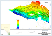
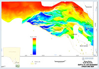
Petroleum Systems Model 2023
The aim of this project was to generate new datasets and new exploration concepts to stimulate the next phase of gas exploration in the onshore Otway Basin to supply South Australian customers. Outputs from the project also provide insights into the potential for Carbon Capture and Storage and underground hydrogen storage in the basin.
Petroleum system modelling (PSM) based on extensive source rock, well and seismic investigations, shows, for the first time, significant oil and gas generation and expulsion in the lightly explored Robe and Tantanoola Troughs.
Figures
Prospectivity
The Otway Basin is one of the best known and most actively explored of the series of Mesozoic rift basins that span the southern coastline of Australia. Seismic studies have shown that its structural evolution is analogous to basins such as the Tucano–Reconcauo Basin of Brazil and the Gabon and Cabinda basins of the west coast of Africa. Each of these basins contains at least one giant oil field.
The recent appraisal of the condensate rich Jacaranda Ridge Field has significantly upgraded the Early Cretaceous in the basin. The main risk factors are structural integrity and small targets; however, regional 3D seismic surveys are being used to address the first risk factor and sophisticated fault leakage analysis of prospects is being conducted by some operators prior to drilling.
The economic viability of small gas discoveries has been improved by the proximity to markets for such discoveries, their potential use for peak electricity generation opportunities in the national electricity market (as demonstrated by the 80 MW Ladbroke Grove Power Station). In 2002–03, the SEA Gas pipeline was constructed to transport offshore Otway gas from the Iona gas facility in Victoria to Adelaide. Origin Energy Retail Ltd constructed and commissioned the SESA Pipeline in 2005. This 45 km pipeline connects the SEA Gas Pipeline in Victoria to Epic Energy’s South East Pipeline System and the Ladbroke Grove Power Station.
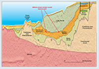
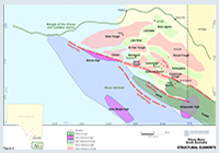
The Otway Basin comprises one of a series of Jurassic to Cretaceous basins with a Tertiary cover (Gambier Basin) that occur along the southern coast of Australia, and which were formed as a result of rifting between the Antarctic and Australian plates. The northern limit is defined by outcropping early Palaeozoic metamorphic and igneous rocks (the Padthaway Ridge) and sediments may occur up to 160 km offshore. To the west, the basin passes into the Duntroon Sub-basin, and in the east continues into Victoria. Offshore it is locally bound by a Palaeozoic outer-margin high or volcanics.
Separate grabens and half grabens filled with a Jurassic to Early Cretaceous rift sequence are interpreted to exist across most of the basin but have only been penetrated onshore. The rate of rifting slowed during the Barremian to Albian but rapidly increased before the end of the Albian in the northern part of the basin. Over 4 km of late Albian to Late Cretaceous sediments occur within the Morum Sub-basin offshore, and the widespread Cenomanian unconformity is predicted not to occur towards the north.
Two major sedimentary sequences are targets for petroleum exploration in South Australia. (i) The Berriasian to Hauterivian sequence (Crayfish Group, early rift) is known only from the northern area, where E–W and NW–SE trending half-grabens (Robe, Penola, St Clair and Tantanoola Troughs contain fluvial to lacustrine sediments that are proven gas reservoirs. (ii) The Late Cretaceous sequence (Sherbrook Group) occurs as a deltaic to deep-water wedge south of the Tartwaup Hinge.
The Otway Basin in South Australia has been actively explored since the 1890s, with the first deep exploration well (Robe 1) being drilled in 1915. Early drilling was based on the theory that coorongite, subsequently found to be a surface algal deposit, was an underground oil seepage. Commercial CO2 was discovered in Caroline 1 in 1968, but it was not until 1987 that the first commercial gas discovery was made at Katnook, followed by discovery of the Ladbroke Grove Field in 1989.
In 2007 the appraisal of the Jacaranda Ridge Field significantly upgraded the northern portion of the Penola Trough as a wet gas–condensate play. The lack of early success may be attributed to poor quality seismic data prior to the early 1980s, and a poor understanding of structure and stratigraphic relationships in the Robe and Penola Troughs. Good-quality modern seismic coverage now exists over the offshore and most of the onshore parts of the basin and stratigraphic relationships are better understood.
Seven gas fields have been discovered in the Otway Basin in South Australia and total original gas in-place is estimated at 128 PJ (121 x 1012 Btu) sales gas. Epic Energy owns and operates a 46 km long pipeline, 150 mm diameter, from the Katnook gas processing plant to the Apcel paper mill at Snuggery, 7 km SE of Millicent. A second line, also 150 mm diameter and 19 km long, runs from this line to Mt Gambier. A third line, 50 mm diameter, runs from Katnook due east for 4.5 km to the Safries potato chip factory, 9 km south of Penola. The pipelines were constructed in 1990 and have a maximum operating pressure of 10 000 kPa (1450 psi). A fourth line, 12 km long and 89 mm diameter, was constructed in the second half of 2000, connecting Kalangadoo to Nangwarry timber mill. None of these pipelines have compression installed.
Gas from producing wells in the Katnook, Haselgrove, Haselgrove South and Redman gas fields is piped to a gas treatment plant located 300 m SE of Katnook 1 and built in 1991. The plant is now operated by Adelaide Energy. Production from these fields is declining as a result of both reservoir depletion and gas market conditions. Long-term options for the Katnook Plant are currently under consideration, taking into account other local discoveries and potential for gas storage.
The gas from these fields requires a minimum of processing to yield sales gas, which is then sold at the pipeline outlet from the Katnook Plant. The main gas customers are the Kimberly Clark paper mill near Millicent, where gas replaced the use of LPG and brown coal briquettes; the Safries potato chip factory near Penola, which was attracted to the area by the natural gas supply; and domestic and industrial customers in Mt Gambier, which were previously supplied tempered LPG via a reticulation network. Condensate is stored onsite at the Katnook Plant before transportation by road tanker to the Shell Refinery at Geelong in Victoria.
In 2002–03, the SEA Gas pipeline was constructed to transport offshore Otway gas from the Iona gas facility in Victoria to Adelaide. Origin Energy Retail Ltd constructed and commissioned the SESA Pipeline in 2005. This 45 km pipeline connects the SEA Gas Pipeline in Victoria to Epic Energy’s South East Pipeline System and the Ladbroke Grove Power Station. As gas production from Ladbroke Grove 2 and 3 ceased in late 2006 and mid 2005, respectively, sales gas from the SESA pipeline now feeds both turbines of the Ladbroke Grove Power Station.
In addition, the South East of South Australia and western Victoria exhibit a high diversity of local industry — consequently, opportunities for gas marketing linked to industry development in the region are good given the industry base and service provision in the region. The region is strategically located between the major cities of Adelaide and Melbourne and the eastern Australian market.
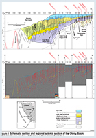
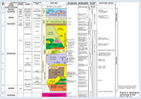
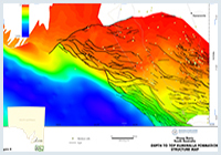
The oldest unit is the Casterton Formation, a volcanic and shale unit that occurs in some wells on the northern flank of the Penola Trough and in Victoria, and may occur in the undrilled deeper parts of the Robe and Penola Troughs. The oldest sequence known in South Australia is the Crayfish Group, which fills half grabens that can be identified in Figure 7.
The first unit is the Pretty Hill Formation, a braided fluvial sandstone that occurs in the deepest parts of the troughs. This is followed by fluviolacustrine shale and siltstone (Laira Formation), which in turn is overlain by the braided fluvial Katnook Sandstone. The Katnook Sandstone thickens to the NW, essentially as a sandy facies of the Laira Formation. On the extreme northern margin, both the Katnook Sandstone and Pretty Hill Formation are absent, and the Crayfish Group comprises only the shaly Laira Formation. The Crayfish Group is unconformably overlain by the Eumeralla Formation, which is a fluvial siltstone – shale sequence with some minor coal and meandering fluvial sandstone units. The Windermere Sandstone is a regionally extensive transgressive sand unit which overlays the Crayfish unconformity and thickens within the Early Cretaceous troughs. The Eumeralla Formation comprises extensive fluviolacustrine volcanogenic sediment deposited during the sag phase of the basin.
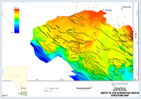
The Late Cretaceous Sherbrook Group overlies the Otway Supergroup as a deltaic wedge that rapidly thickens to the south accounting for most of the sediment in the Morum Sub-basin. In the northern part of the basin, where the group is thin, it comprises a coarse sandstone that represents a condensed equivalent of the Copa, Waarre, Flaxman, Belfast, Paaratte and Timboon units found to the south. Offshore, beyond the present day shelf, thick packages of high-amplitude reflectors indicate the possible presence of paralic oil-prone coals or marine oil shale. From Belfast Mudstone to Timboon Sandstone the sequence represents a prograding delta, with early marine influence and deep-water submarine slope-fans along the outer margin. A regional section across the Otway Basin is shown in Figure 3.
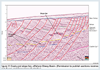
The Casterton Formation represents the richest source rock of the Otway Supergroup that is thought to be the source of commercial gas accumulations now in production in the Penola Trough region. It comprises pre-rift to early syn-rift interbedded shales, siltstones and sandstones and volcanic lithologies that have only been sparsely intersected. The formation reaches a maximum known thickness of 230 m in Casterton 1 well (Victorian Type Section) and 43m in Sawpit 1 (SA reference section; Figure 12) although it is thought to be up to 500 m in the Robe Trough at depths greater than 4000 m based on seismic interpretation (Morton and Drexel, 1995). To date, the formation has been mostly intersected on the northern flanks where it is marginally mature for oil (as evidenced by oil shows in several wells) but not viable as a shale gas play.
TOC values range from 0.6 to 9 percent, averaging 1.9 percent (39 samples; 6 wells). The Tmax vs. HI cross plot shows that these organic rich shales are Type II (algal rich oil prone kerogen) to Type III (Gas prone) at the threshold of the oil window. However, in the deeper portions of the Penola, Robe and Saint Clair troughs they are expected to be gas prone with liquids potential.
Maturity modelling indicates that the Casterton Formation lies within the gas window at depths in excess of 3800m in the Penola Trough and Robe Trough but may be locally shallower in the Robe Trough where seismic is poor.
The Upper and Lower Sawpit shales represent lacustrine deposits at the base of the Crayfish Group and can reach thicknesses up 900 m and 250 m thick respectively. The shales are better developed on the northern flank of the Penola Trough, away from the axial drainage in the central part of the trough which is dominated by stacked fluvial channel fill of Pretty Hill Sandstone or Sawpit Sandstone.
Rock Eval analyses of samples from the Upper and Lower Sawpit Shales indicate that the shale is dominated by Type III gas prone kerogen with some Type II algal rich kerogen present. TOC values range 0.37 to 2.61 percent and average 1.12 percent (10 wells, 87 samples).
Maturity modelling suggest that the northern flank of the Otway Basin represents the most prospective area for shale oil play where the Casterton Formation lies in the oil window at depths between 2300 m to ~3050 m (early mature for oil; Ro 0.7 to 1.0 percent) and ~3050 m to 3800 m (later mature for oil; Ro 1.0 to 1.3 percent) in the Robe, Penola, Rivoli and St, Clair troughs. In South Australia oil is produced in negligible amounts from Caroline 1 and in 1992 heavy crude was recovered from Sawpit 1 over a 32 m interval below 2514 m. The oil is presumably sourced from Otway Supergroup sediments. In 1994 Wynn 1 recorded the first liquid hydrocabon flow in the Otway Basin and Killanoola 1 (1998) produced 160 kL (1000 bbl) on test, however neither are currently deemed economic.
Maturity modelling in the Katnook area of the Penola Trough indicates that peak gas generation from the Casterton Formation and Upper and Lower Sawpit Shales occurred in the Maastrichtian at ~73 Ma and has remained in the gas window to present day at depths below ~3800 m.
The Eumeralla Formation is not deep enough in the northern portion of the basin to be a source and shallow northern targets would rely on long-range migration, which may be impeded by the high density of E–W faults. However to the south, where thick Sherbrook sediments occur, the Eumeralla could be a source for Waarre and Flaxman targets. Offshore beyond the present day shelf, possible thick, oil-prone coal measures, or oil shale equivalent to the world wide Albian ocean anoxic event, occur.
The Belfast Mudstone is a relatively poor gas-prone source rock, and is only marginally mature (VR = 0.6%), even in the deepest wells drilled to date. The CO2 in Caroline Field has a volcanic source, assumed to be from the Holocene Mt Gambier volcanic chain, which trends NW through the Tantanoola Trough. Carbon dioxide from a magmatic source has also been noted in Ladbroke Grove Field and Kalangadoo 1. The Caroline 1 well is the single most profitable well in South Australia.
The main producing gas reservoir in the South Australian sector of the onshore Otway Basin is the Pretty Hill Formation, which in the Katnook Field has porosities in excess of 25%, permeabilities in excess of 1000 mD, and has flowed over 451 000 m3 (16.01 mmcf) gas per day on test. Reservoir permeability does not appear to decrease with increasing depth of burial, although only the upper part of the Pretty Hill Formation is generally of good quality. Reservoir quality in the Windermere Sandstone Member is excellent, although the low relief structures can make it difficult to avoid water production problems.
Victorian production and limited South Australian log data indicate that reservoir quality is excellent for the Waarre, Flaxman and intra-Belfast units.
Conventional
Proven plays in South Australia include the fault bounded 4 way dip closures in the Pretty Hill and Windermere Sandstone in the Penola trough (oil and or wet gas), although gas discoveries to date are relatively modest in size (average recoverable reserves per field is ~23 PJ (21 bcf)), Fault leakage is a key risk factor. There is considerable potential for significant oil discoveries particularly in the northern flanks of the basin in the future.
In the northern part of the basin, where exploration is for Otway Supergroup targets, Pretty Hill Formation reservoirs of the fields in the Penola Trough comprise complex, steep sided, E–W tilted fault blocks, with the upper Sawpit shale member and Laira Formation acting as the seals. Common palaeohydrocarbon columns have been intersected and leakage is probably caused by the creation of structural permeability across the regional seal. The location of leakage depends on the interaction between the seal, associated faults, and the regional stress field.
Traps for Windermere reservoirs comprise much lower relief domes (close to the resolution limit of seismic mapping) that are generally un-faulted, and sealed by the Eumeralla Formation. The base Eumeralla seal is likely to improve towards the SW. Considerable potential exists for stratigraphic traps, either as meandering fluvial channels in the Eumeralla Formation (as in Katnook Field), or as pinch-outs of the Pretty Hill Formation to the north.
The Flaxman–Waarre units have proven to be excellent gas reservoirs in the Victorian portion of the basin (up to 350 PJ (~321 bcf) in the Minerva Field and ~0.8 tcf in the Thylacine discovery), and in South Australia contain the Caroline CO2 field. Traps are generally NE tilted fault blocks, bounded by closely spaced rift parallel faults. Offshore, potential exists for overpressured submarine slope-fan traps encased within the Belfast Mudstone.
Unconventional
The principal targets for shale gas or oil in the onshore Otway Basin are thick basal shale sequences within the Otway Supergroup, in particular the Casterton Formation and the Upper and Lower Sawpit shales. These non-marine shales all have good shale gas potential in the deeper portions of the basin. Complex faulting resulting from rift tectonics, while risk factor for conventional traps, could be advantageous for unconventional gas through enhancement of natural fracture networks that would improve connection with, and drainage of, the rock matrix.
Potential also exists for tight gas in the basal sands of the Pretty Hill Formation, particularly in the deeper portions of the Penola and Robe Troughs.
The Otway Basin in South Australia is an immature exploration province, with high potential for further discoveries (Figure 13). Although gas discoveries to date are relatively modest in size (average recoverable reserves per field is ~23 PJ (21 bcf)), some discoveries in the offshore Victorian portion of the basin are an order of magnitude larger (up to 350 PJ (~321 bcf) in the Minerva Field and ~0.8 tcf in the Thylacine discovery). Oil discoveries have only recently been made, and there is considerable potential for significant oil discoveries in the future. Table 1 summarises the undiscovered potential for recoverable sales gas resources in some the key plays of the onshore South Australian portion of the basin. The offshore potential and unconventional potential is as yet unquantified.
Table 1: Undiscovered recoverable sales gas resources of the onshore Otway Basin (South Australia)
UNDISCOVERED POTENTIAL PJ (~bcf) | ||||||
| PLAY | Probability that the ultimate potential will exceed the stated value: | |||||
| 90% | 50% | 10% | ||||
| Waarre-Flaxman | 30 | (27) | 150 | (137) | 560 | (513) |
| Crayfish | 120 | (110) | 680 | (623) | 2330 | (2135) |
| Total | 180 | (165) | 900 | (825) | 2760 | (2530) |
Note: Total do not add arithmetically as they are Monte Carlo simulations. Current 2000.
Climate, land and sea use
The climate in the South East is characterised by mild, dry summers and cold, wet winters, consequently exploration activities are generally conducted in the summer and autumn months of December through to April. However, with advanced preparation of sites it is possible to conduct drilling activities year round. The main land use in the area is for mixed farming ranging from sheep and cattle grazing to crops and wine grapes. The South East is characterised by a near-surface unconfined aquifer which is the main water supply for the landholders, and requires consideration while conducting exploration activities.
The continental shelf is 100+ km wide in the north and only ~30 km wide in the south. Whale and fishing activity need to be taken into account when planning offshore programs.
National parks and reserves
There are a number of national parks and other areas of remnant native vegetation in the area, in some of which exploration is permitted, and in others their small size makes it possible to work around them. The reserves have been created to conserve the best examples of vegetation and landforms in the region. There are three types of South Australian reserves in the Otway Basin including conservation parks, national parks and game reserves. The conditions of access vary from park to park, based upon the type of reserve classification, the activity proposed and its likely impact on the environment.
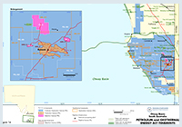
Figure 14 shows the licence status at the time of publication. Use this link for further information on holders of petroleum tenements in South Australia.
Offshore Exploration Permits for Petroleum (EPPs)
All Offshore Petroleum Permit areas located beyond three nautical miles from the territorial sea baseline are administered by the National Offshore Petroleum Titles Administrator (NOPTA).
Further information on permits administered by NOPTA is available via the National Electronic Approvals Tracking System (NEATS)
Bailey, A., King, R., Holford, S., Sage, J., Backe, G., and Hand,M. 2014 Remote sensing of subsurface fractures in the Otway Basin, South Australia. J. Geophys. Res. Solid Earth, 11:6591–6612
Boult PJ, 2005. Morum Sub-basin petroleum system, South Australia. Department of Primary Industries and Resources. Narrated PowerPoint presentation.
Boult PL, McKirdy D, Blevin J, Heggeland R, Lang S and Vinall D. 2005 The Morum Sub-basin petroleum system, Otway Basin, South Australia. PowerPoint presentation (converted to PDF).
Boult PL, McKirdy D, Blevin J, Heggeland R, Lang S and Vinall D. 2005 The oil-prone Morum Sub-basin petroleum system, Otway Basin, South Australia. MESA Journal 38 pages 28 to 33
Boult PJ, Camac BA and Davids AW, 2002. 3D fault modelling and assessment of top seal structural permeability — Penola Trough, onshore Otway Basin. APPEA Journal, 42(1):151-166.
Boult PJ and Hibburt JE eds, 2002. The petroleum geology of South Australia. Volume 1: Otway Basin. 2nd edn. South Australia. Department of Primary Industries and Resources. Petroleum Geology of South Australia Series.
Cubitt C, Kirk R, Rady T and Tiainen S, 2024. Gross depositional environment mapping in the onshore South Australian Otway Basin: an example of data integration. Australian Energy Producers Journal 64(S1), S347–S353.
Edwards C, Rady T, Cubitt C, Kirk R and Tiainen S, 2024. Petroleum Systems Analysis of the Onshore Otway Basin, South Australia. Australian Energy Producers Journal 64(S1), S359–S364
Edwards DS, Struckmeyer, HIM, Bradshaw MT and Skinner JE, 1999. Geochemical characteristics of Australia’s southern margin petroleum systems. APPEA Journal, 39(1):297-321.
Hall, P.A., McKirdy, D.M., Grice, K ,, Edwards, D.S. 2014 Australasian asphaltite strandings: Their origin reviewed in light of the effects of weathering and biodegradation on their biomarker and isotopic profiles Marine and Petroleum Geology 57: 572-593
Jones RM, Boult PJ, Hillis RR, Mildrren SD and Kaldi J, 2000. Integrated hydrocarbon seal evaluation in the Penola Trough, Otway Basin. APPEA Journal, 40(1):194-211.
King, R., Holford, S., Hillis, R.,Tuitt, A., Swierczek, E., Backé, G., D. Tassone, D., and M. Tingay, M., 2012 Reassessing the in situ stress regimes of Australia’s petroleum basins. APPEA Journal, 52:415-425
Lovibond R, Sutthill RJ and Skinner JE, 1995. The hydrocarbon potential of the Penola Trough, Otway Basin. APPEA Journal, 35(1):358-371.
Lyon PJ, Boult PJ, Hillis RR and Bierbrauer K, 2007. Basement controls on fault development in the Penola Trough, Otway Basin, and implications for fault-bounded hydrocarbon traps. Australian Journal of Earth Sciences, 54:675-689.
McClay KR, Longley IM, Fitzpatrick JP, King SJ and Somerville RM, 2001. Analogue modelling of extensional fault architecture: comparisons with natural rift fault systems. In: Hill KC and Bernecker T eds. Eastern Australasian Basins Symposium, A refocussed energy perspective for the future, Melbourne, 2001. Petroleum Exploration Society of Australia. Special Publication, pp. 573-584.
Morton JGG, 1990. Revisions to stratigraphic nomenclature of the Otway Basin, South Australia. South Australia. Geological Survey. Quarterly Geological Notes, 116:2-19.
Norvick MS and Smith MA, 2001. Mapping the plate tectonic reconstruction of southern and southeastern Australia and implications for petroleum systems. APPEA Journal, 41(1):15-35.
Palmowski D, Hill KC and Hoffman N, 2004. Structural-stratigraphic styles and evolution of the offshore Otway Basin – a structural seismic analysis. In: Boult PJ, Johns DR and Lang SC eds, PESA’s Eastern Australasian Basin Symposium II, Adelaide 2004. Petroleum Exploration Society of Australia. Special Publication, pp. 75-96.
Teasdale J, Pryer L, Stuart-Smith P, Romine K, Loutit T, Etheridge M, Shi Z, Foss C, Vizy J, Henley P and Kyan D, 2001. Otway and Sorell basins SEEBASE Project. SRK Consulting report, SRK Project Code: GA701. South Australia. Department of Primary Industries and Resources. Open file Envelope, 9889 (unpublished).
Tiainen S, Kirk R, Cubitt C and Rady T, 2025. Revisiting the rocks discovers turbidites and a new exploration play in the Penola Trough, Otway Basin, South Australia. Australian Energy Producers Journal 64(S1), S435–S440.
For more information, contact:
-
Geoscience Australia has the latest information on Australia’s offshore basins:
Otway Basin | Geoscience Australia
Department for Energy and Mining, all onshore energy resources queries:
DEM.Petroleum@sa.gov.au -
Refer to NOPIMS for up to date offshore well information:
National Offshore Petroleum Information Management System (NOPIMS)