
On this page
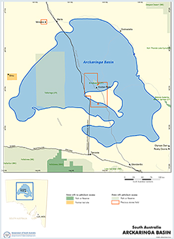 The Arckaringa Basin is a Permo-Carboniferous intracratonic basin.
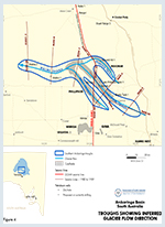
The basin comprises two main depocentres, the Boorthanna Trough in the east and the southern Arckaringa troughs (West, Phillipson, Penrhyn and Wallira).
Summary
| Age | Permo-Carboniferous |
|---|---|
| Area in South Australia | 80,00 km2 (30,890 sq. miles) |
| Exploration well density | 1 well per 7,272 km2 (1 well per 2808 sq. miles) |
| Success ratio | no discoveries |
| Depth to target zone | 300 - 1500 m |
| Thickness | Up to 1300 m |
| Hydrocarbon shows | Oil shows and strong petroliferous odour in Mount Toondina Formation sandstones cored in Maglia 1. Gassy salt water recovered in base Permian DSTs in Cootanoorina 1. Trace gas and bituminous material in the pre-Permian succession. |
| First commercial discovery | None |
| Identified reserves | Nil |
| Undiscovered resources (50%) | Not determined |
| Production | Nil |
| Basin type | Intracratonic |
| Depositional setting | Glacigene, marine, non-marine |
| Reservoirs | Sandstone (carbonate underlying Cambrian and Adelaide Rift succession) |
| Regional structure |
Anticlines (diapers in underlying Adelaide Rift succession) |
| Seals | Shale, siltstone (evaporite in underlying Adelaide Rift succession) |
| Source rocks | Non-marine and marine siltstone-shale |
| Depth to oil/gas window | 700 m |
| Number of wells | 11 petroleum, 9 coal seam gas, 14 stratigraphic (including a deep hole drilled in 2011 to test shale oil/oil shale potential of the Stuart Range Formation, numerous mineral |
| Seismic line km | 6,938 2D |

Prospectivity
The Arckaringa Basin is a Permo-Carboniferous intracratonic basin which covers an area of ~80 000 km2. The basin comprises two main depocentres, the Boorthanna Trough in the east and the southern Arckaringa troughs (West, Phillipson, Penrhyn and Wallira).
In the south, separated by shallow basement with a thin veneer of Permian sediments. The troughs contain up to 1300 m of Permo-Carboniferous sediments overlain by up to 300 m of Late Jurassic to Early Cretaceous Eromanga Basin sediments and generally less than 10 m of Tertiary cover.
The Boorthanna Trough is broad, and underlain in part by Neoproterozoic and early Palaeozoic sediments of the Adelaide Rift complex. The southern Arckaringa troughs are narrow, and underlain by Archaean to Early Mesoproterozoic rocks of the Gawler Craton. Both depocentres show evidence of infill of basement topography.
Southern Arckaringa Troughs
In the past the southern Arckaringa troughs have been described as erosional features formed by glacial scour by some workers, and as graben structures by others. Debate over the origin of the troughs continues today (see Menpes et al, 2010). DEM’s interpretation of the depositional and tectonic history is summarised below:
- Incision of deep glacial valleys
- Valleys fill with glacial and marine sediments of the Boorthanna and Stuart Range formations – some seismic evidence of sea-level fluctuations and minor contraction.
- Progradation of the Mount Toondina delta system over the basin. Minor differential growth of this succession, as indicated by seismic and coal seam geometries, may be the result of ongoing minor contraction and differential compaction.
- Contraction culminates with gentle folding of the succession, uplift and erosion. The vitrinite reflectance profile at Arkeeta 1 suggests that approximately 500m of Early Permian section was stripped from the centre of the Phillipson Trough. Coal seam correlations demonstrate the subcrop relationship of the coal seams beneath the Eromanga Basin, indicating that folding and erosion occurred prior to deposition of the Eromanga Basin
Boorthanna Trough
Diapirism in the Neoproterozoic Adelaide Rift succession is evident on a number of seismic lines over the Boorthanna Trough, and Permian sediments at Mt Toondina are deformed by a piercement structure. Extensional tectonics and differential loading are postulated as the driving mechanisms for initial diapiric movement and subsequent growth, with Neoproterozoic salt as the source.
There is also seismic evidence for salt movement influencing deposition during the Permian. Otherwise the Permian depositional and tectonic history in the Boorthanna Trough is similar to that in the southern Arckaringa troughs.
Vitrinite reflectance data from three wells in the Boorthanna Trough suggests that the Permian section has been subjected to pre-Jurassic uplift and erosion in the order of 0.5–1 km. Minor late stage structuring occurred in the Late Miocene.
Petroleum exploration commenced in the 1960s with Delhi’s Oodnadatta aeromagnetic survey and was followed by gravity surveys (BMR, Dalhousie; and two by the department). Limited reflection and refraction seismic was also recorded in this period.
These surveys delineated the deep Boorthanna Trough. The first exploration wells were Cootanoorina 1 (1967, Department of Mines) and Weedina 1 (1970, Pexa Oil). There were no indications of hydrocarbons in the Permian section, but trace gas and bituminous material were recorded from the Cootanoorina Formation.
In 1969 the department commenced a seismic and seven well stratigraphic drilling program aimed at evaluating the basin outside PELs 5 and 6 area (Boorthanna Trough). At the same time surveys continued in the Boorthanna Trough (seismic and one wildcat — Weedina 1) commissioned by Pexa as part of a farmin commitment. No significant hydrocarbons were recorded.
The next phase of exploration was by Delhi in the mid 1980s and included seismic and two wells. Hanns Knob 1 terminated in Cootanoorina Formation and Birribiana 1 in Proterozoic dolerite. Traces of ditch gas were recorded in the latter. The Arckaringa Block was relinquished by Santos and Delhi in 1989.
The Phillipson Trough in the southern Arckaringa Basin was explored by CRA in the mid 1980s. Exploration included seismic and one well. Arkeeta 1, drilled in 1986, intersected a thick Permian succession overlying metasediments and volcanics of the Gawler Range Volcanics (Gawler Craton).
Attempts so far to drill a diapir have been unsuccessful or inconclusive. The department’s drillholes Toondina 1 and 2 did not penetrate beneath the Permian sequence. Roebuck Resources’ mineral exploration drillholes, Todmorden 1 and 2, drilled into Cootanoorina Formation.
Currently there is renewed interest in the conventional hydrocarbon potential of the Early Permian and underlying Cambrian and Adelaide Rift succession. This follows the intersection of oil shows in sandstones of the upper Mount Toondina Formation in Maglia 1 in 2010. Oil samples were extracted and analysed and determined to be sourced from pre-Permian carbonates. Linc Energy drilled three wells targeting conventional hydrocarbons in the Arckaringa Basin in 2011.
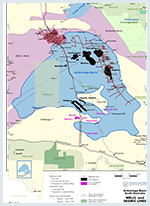
The 2008 Gawler Craton-Officer Basin-Musgrave Province-Amadeus Basin seismic line (GOMA, 08GA-OM1) acquired by Geoscience Australia transects the Arckaringa Basin along the Adelaide-Alice Springs railway line. The GOMA line crosses the Phillipson and Penrhyn troughs, but lies west of the Boorthanna Trough. SAPEX Limited (an operating Division of Linc Energy) acquired 1133 line km of 2D seismic data over the Boorthanna Trough in 2011.
SAPEX operate PELs 117-124 (granted in 2006) and have lodged adjacent PELAs 604 and 635. SAPEX are targeting coal seam methane plays in the Mt Toondina Formation, conventional oil in the underlying Officer Basin and, Boorthanna Formation and Stuart Range Formation shale oil.
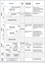
The early Palaeozoic Cootanoorina Formation and Neoproterozoic Adelaide Rift succession underlies the Permian in the Boorthanna Trough. The Cootanoorina Formation comprises a shallow marine carbonate–siliciclastic sequence and is presumed to be equivalent to the Early Cambrian Ouldburra Formation of the Officer Basin.
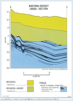
There are three major Early Permian units. The Boorthanna Formation comprises a glacigene sequence with marine facies towards the top. Lithologies include diamictite, rhythmically bedded sandstone (probably representing deposition by turbidity currents) and laminated mudstone. The overlying Stuart Range Formation is generally a homogeneous shale with minor siltstone and sandstone, deposited in quiet, restricted marine conditions. This is in turn overlain by Mt Toondina Formation consisting of a lowermost deltaic sequence and an uppermost fluviolacustrine succession with intermittent coal swamp development.
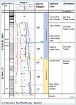
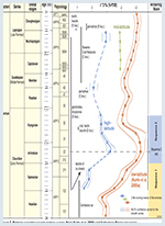
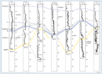
A recent detailed palynological study has resulted in a revised biostratigraphy for the Arckaringa Basin, see figures below, and has enabled correlation of the Arckaringa Basin succession with oxygen isotope curves published by Korte et al, 2008. These curves, derived from unaltered brachiopod and bivalve shells in low, mid and high palaeo-latitude Permian basins, indicate that the Arckaringa Basin sediments accumulated during a second order climate cycle in the Early Permian. Maximum sea-water temperatures during the Artinskian, as indicated by the oxygen isotope curves, correspond to the peak marine transgression in the Arckaringa Basin (Menpes, 2013).
The Arckaringa Basin has been divided into two stratigraphic sequences, separated by an erosional sequence boundary (Menpes, 2012 and Menpes, 2013). The first sequence comprises the glacigene and marine sediments of the Boorthanna Formation, the second sequence comprises the organic rich Stuart Range Formation and the overlying Mount Toondina Formation. A maximum flooding surface in the second sequence has been identified on seismic lines in the Boorthanna Trough.
Flattening seismic lines on this horizon clearly demonstrates the downlapping of shingled clinoforms onto the surface. A prominent gamma-ray peak corresponding to the maximum flooding surface occurs at the top of the PP2.2.1 biostratigraphic unit.
Boorthanna Formation (Sequence 1)
Boorthanna Formation Total Organic Carbon (TOC) content is generally <0.5%. However two samples from the Boorthanna Formation in Linc Energy’s 2011 Arck 1 well returned TOC values of 5.7% and 6.2%.
Stuart Range Formation (Sequence 2)
Organic rich shales of the Stuart Range Formation have high TOC and HI (hydrogen index) values indicating excellent oil-prone source potential. In Arkeeta 1, all twelve samples from a 200m interval recorded TOC values >2% (up to 7.4%) and HI values >400 (up to 654). The Tmax vs HI cross plot shows that these organic rich shales are Type II source rocks at the threshold of oil generation. The Arck 1 stratigraphic well also intersected around 70m of organic rich shale (Type I/II kerogen) with very high potential oil yields. Analyses indicate that these shales are also at the onset of oil generation (the target maturity window for shale oil plays in North America is 0.6-0.8% Ro).
The Stuart Range Formation organic rich shales were deposited during the Sequence 2 marine transgression. The TOC and HI profiles of the Stuart Range Formation are typical of organic rich shales deposited during a marine transgression onto a platform/ramp margin. The TOC maximum occurs just above the transgressive surface, gradually declining to the maximum flooding surface/downlap surface (Bohacs, 1998).
A detailed palynological study of cuttings and sidewall core samples from Arkeeta indicates a lacustrine to brackish-restricted marine environment during deposition of the organic rich shales. High organic carbon contents and hydrogen indices indicate anoxic bottom water conditions suitable for the preservation of organic matter. The presence of mixed lacustrine to brackish marine environments and anoxic bottom water conditions suggests a Baltic Sea analogy, where high fresh-water runoff into a restricted sea-way results in density stratification of the water column. High fresh-water runoff (including melt-water) into restricted seaways along the Arckaringa troughs is likely to have resulted in similar conditions. In the Boorthanna trough an organic petrology study of the organic rich shales has shown that very abundant alginite is present in a significant number of samples.
Permian reservoirs
Sandstone in the Mt Toondina Formation generally exhibits low porosity (6–9%). However in William Creek 1 (Linc Energy, 2011) good quality reservoirs were intersected, with 41m net sand averaging 25% porosity encountered.
The Boorthanna Formation contains several thick units of porous and permeable sandstone. In Cootanoorina 2 (Linc Energy, 2011), good quality reservoir sands with up to 17% calculated porosity were intersected in a thin Boorthanna Formation (16m net sand, 18m total thickness). In William Creek 1, 126m of net sand averaging 25% calculated porosity was encountered.
Pre-Permian reservoirs
Secondary vugular porosity and minor open parting along stylolites are observed in Cootanoorina Formation carbonate. A total of 52.1m of net reservoir was interpreted from wireline logs in the Pre-Permian section of Haystack 1 (Linc Energy, 2011), with calculated porosities ranging from 8.0% to 16.5%. The pre-Permian section in Cootanoorina 2, dominated by red beds, dolomites and dolomitic sandstones, was very tight with only 34m net reservoir (706m total thickness) with calculated porosities ranging from 8% to 18%.
Permian seals
Stuart Range Formation and Bulldog Shale (Eromanga Basin) provide regional seals. Intraformational shale and siltstone in the Boorthanna and Mt Toondina formations may locally provide seals.
Conventional
Four way dip closures on sandstones of the Boorthanna Formation and Pre-Permian sandstones/carbonates have only parlially beentested, and potential remains for oil discoveries. Traps range from simple domes and faulted anticlines to potential diapiric traps. The presence of tilted fault blocks sealed by inferred massive salt horizons in the Neoproterozoic Adelaide Rift succession are tantalising, given the success of sub-salt rift block plays elsewhere in the world.
Unconventional
Coal gasification play
The Arckaringa Coal-to-Liquids and Power Project, a Joint Venture between Altona Energy and partner CNOOC New Energy Investment Co., Ltd. (CNOOC-NEI), is completing a bankable feasibility study for mining part of the Wintinna coal deposit (10Mtpa base case) supplying coal to a coal-to-liquids plant with an output of 10 MMbbls per annum liquid fuels (mainly ultra clean diesel) as well as a co-generation power plant delivering 560 MW per annum to the national power grid (Schrape, 2011). Elsewhere in the Arckaringa Basin, Linc Energy is assessing coal deposits for in-situ gasification and coal seam gas prospectivity.
Coal seam gas play
The Arckaringa Basin coals are lignite A/sub-bituminous C rank coals and are therefore not sufficiently mature to have generated significant thermogenic gas volumes. However the coal seams subcrop the Algebuckina Sandstone aquifer in part, meaning that microorganisms capable of producing methane in anaerobic conditions (methanogenic microorganisms) can be introduced to the coal seams at the aquifer subcrop, resulting in biogenic gas generation.
Shale oil and biogenic shale gas plays
A preliminary correlation of the Early Permian succession in the Southern Arckaringa troughs and the Boorthanna Trough has been postulated; in particular the organic rich marine shales appear to have been deposited in a transgressive system that can be identified in both areas of the basin. The organic rich shales will be an exciting shale oil target if sufficient maturity levels can be identified in the basin. Alternatively biogenically generated shale gas may be a possibility in parts of the basin
There is no estimate of undiscovered resources. Prospective unrisked resources were identified by Gustavson Associates and DeGolyer and MacNaughton in 2013.
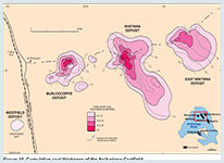
Seven deposits of lignite A/sub-bituminous C rank coal (American Society for Testing and Materials classification) aggregating more than 20 Gt of measured, indicated and inferred resource have been identified in the upper part of the Mt Toondina Formation. These are multi-seam deposits with individual seams ranging up to 10 m, with a cumulative thickness of up to 30 m.
Altona Energy has undertaken a Bankable Feasibility Study (BFS) for an integrated Coal to Liquid (CTL) plant with a co-generation power facility. The company’s pre-feasibility studies established a base case project comprising:
- An open cut mine at Wintinna producing 10 MTPA coal
- 10 MBPA liquid fuels (mainly ultra clean diesel)
- 1140 MW of power - 560 MW for delivery to the national grid
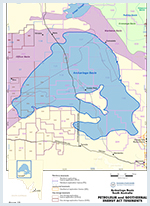
The Tallaringa Conservation Park overlies the Arckaringa Basin. Exploration is permitted.
The western Arckaringa Basin underlies Maralinga Tjarutja and Anangu Pitjantjatjara Yankunytjatjara Lands. Access to these areas is discussed under Aboriginal interests. Both Pitjantjatjara and Maralinga people have expressed willingness to allow further petroleum exploration on their lands.
Entry to the Woomera Prohibited Area (WPA), main roads excepted, must be cleared with the Director, Woomera Test Facility located at the RAAF Base in Edinburgh, South Australia. Operators proposing to conduct activities within the prohibited area are required to liaise with the Director, Woomera Test Facility and the Defence Legal Service to determine appropriate levels of insurance and indemnities to the Commonwealth. Some areas of the Woomera Prohibited Area (WPA) may be subject to access restrictions.
The Petroleum and Geothermal Energy Act 2000 broadened the scope of regulated resources for which exploration licences may be granted. Seven new PELs (117–119, 121–124) were granted to SAPEX Ltd in September 2006 for oil and coal seam methane exploration. Before these licences could be offered, pursuant to the Native Title Act 1993, it was necessary to conclude native title land access agreements over the areas to be licensed.
Bohacs KM, 1998. Contrasting Expressions of Depositional Sequences in Mudrocks from Marine to non Marine Environs. In Schieber J, Zimmerle W and Sethi P eds, Shales and Mudstones Volume I.
Cotton TB, Scardigno MF and Hibburt JE eds, 2006. The petroleum geology of South Australia. Volume 2: Eromanga Basin. 2nd edition. South Australia. Department of State Development. Petroleum Geology of South Australia Series.
Debenham, N., Kennedy, M. J., Loehr, S. C., Hall, P. A., McKirdy, D. and Loehr S. C. 2014 A new model for cold climate source rock preservation in the Arckaringa Basin. Abstract, 18th Australian Organic Geochemistry Conference
Hibburt J E, 1984. A review of exploration in the Arckaringa Basin 1887–1983. South Australia. Department of Mines and Energy. Report Book, 84/00001.
Jones PJ, 1988. Evidence for diapirism in the Arckaringa Basin, South Australia. University of Adelaide. National Centre for Petroleum Geology and Geophysics. BSc (Hons) thesis (unpublished).
Korte C, Jones PJ, Brand U, Mertmann D, and Veizer J, 2008. Oxygen isotope values from high-latitudes: Clues for Permian sea-surface temperature gradients and Late Palaeozoic deglaciation. Palaeogeography, Palaeoclimatology, Palaeoecology 269 (2008), 1-16
McBain D,1987. Arkeeta No. 1 Well Completion Report. PEL 24, South Australia. CRAE Report No. 302889. CRA Exploration Pty Limited (unpublished)
Menpes SA, Korsch, RJ and Carr LK, 2010. 2008 Gawler Craton – Officer Basin – Musgrave Province – Amadeus Basin (GOMA) seismic survey, 08GA-OM1: Geological interpretation of the Arckaringa Basin. In: Korsch RJ. and Kositcin N, editors, GOMA (Gawler Craton – Officer Basin – Musgrave Province – Amadeus Basin) Seismic and MT Workshop 2010. Geoscience Australia, Record, 2010/39, 16-31.
Menpes SA, Korsch RJ and Carr LK, 2010. Arckaringa Basin. Interpretation of the GOMA seismic line. PowerPoint presentation with speakers notes presented at the GOMA (Gawler Craton – Officer Basin – Musgrave Province – Amadeus Basin) Seismic and MT Workshop 2010, November 25th 2010.
Menpes SA; 2011. Sub-salt Petroleum Potential of the Neoproterozoic Adelaide Rift, South Australia. Oral Presentation AAPG ACE 2011. Search and Discovery Article #10345.
Menpes, SA; 2012. Unconventional Hydrocarbon Potential of the Arckaringa Basin, South Australia. In: Ambrose GJ and Scott J. eds Central Australian Basin Symposium III. Petroleum Exploration Society of Australia, Special Publication.
Menpes SA, Hill A, and Sansome A, 2012. Unconventional hydrocarbon plays in the Permian Succession, South Australia. Eastern Australasian Basin Symposium IV, Petroleum Exploration Society of Australia, Special Publication.
Menpes SA, 2013. Organic Rich Shale in Permian Fjords – A Potential Resource Play in the Arckaringa Basin, South Australia. Oral Presentation AAPG ACE 2013.
Rogers PA and Freeman PJ, 1996. WARRINER, South Australia, sheet SH53-3. South Australia. Geological Survey. 1:250 000 Series — Explanatory Notes.
SADME, 1991. Coal deposits in South Australia. South Australia. Department of State Development. Information Sheet M23.
Santos Ltd, Western Team, 1988. Arckaringa Block. Acreage assessment report. South Australia. Department of Primary Industries and Resources. Open file Envelope, 4878 (unpublished).