
On this page
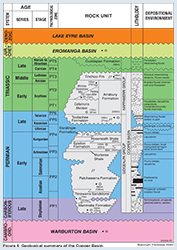
The Cooper Basin is a Late Carboniferous to Triassic basin.
It lies unconformably over early Paleozoic sediments of the Warburton Basin and is overlain disconformably by the central Eromanga Basin. In the northern Patchawarra Trough, the Cooper Basin is locally overlain by the Late Triassic Cuddapan Formation.
For information on Cooper Basin structural and tectonic history, new seismic mapping, litho- and biostratigraphy, source rocks and maturity, reservoirs, seals, trap development, discovered reserves, field reviews, undiscovered potential, exploration history, infrastructure, economics and land access considerations see the Petroleum geology of South Australia. Volume 4: Cooper Basin.
Cooper Basin plays
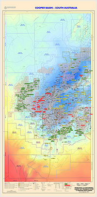
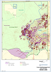
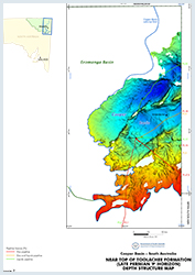
Horizon depth maps
Summary
| Age | Late Carboniferous - Middle Triassic |
|---|---|
| Area in South Australia | 35 000 km2 (13 510 sq miles) |
| Exploration Well Density | 1 well per 58km2 ( well per 23 sq. miles) |
| Success Ratio (conventional plays) | 0.442 |
| Depth to target zone | 1250 - 3670m. |
| Thickness | 2500m. |
| Hydrocarbon shows | Widespread over 8 formations. |
| First commercial discovery | 1963 gas (Gidgealpa 2). |
| Current Production | For the latest figures see Production and statistics |
| Basin type | Intracratonic. |
| Depositional setting | Non-marine. |
| Reservoirs | Fluvial, deltaic, shoreface sandstones. |
| Regional structure | Faulted anticlines. |
| Seals | Lacustrine shale, coal. |
| Source rocks | Carbonaceous shale, thick (up to 30m) coal. |
| Number of wells (July 2021) | 1976 (1361 development/appraisal) |
| Seismic line km | 76224 2D; 15970 km2 3D (104749 km ) |
Figures
Prospectivity
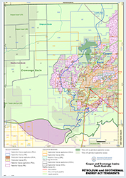
Petroleum exploration commenced in 1954 with the granting of an exploration licence to Santos. Exploration commenced in 1959 with the drilling of Innamincka 1 following a reflection–refraction survey carried out over the Innamincka Dome with Delhi Petroleum as operator. Additional reflection surveys over the ensuing years led to the discovery of gas in Gidgealpa 2 in 1963. Since then, around 2000 wells have been drilled and more than 80 000 km of seismic have been recorded.
The Department held three releases of former PELs 5 and 6 acreage between 1998 and 2000, with a total of 27 new petroleum exploration licences offered. In November 2001 the first of the new licences were granted to the successful bidders in the CO98 acreage release following signing of a historic native title agreement. Access agreements were completed in 2002–03 for the CO99 and CO2000 acreage release areas.
A vigorous new phase of exploration commenced in 2002 resulting in an increased rate of new oil discoveries that continues today. 11 acreage releases have occurred since 1998, enabled by the Petroleum Act 2000 then the Petroleum and Geothermal Energy Act 2000, conjunctive agreements with Native Title claimants, access to multiple-use Innamincka and Strzelecki Regional Reserves and transparent bid assessment processes.
Since late 2011, and more recently exploration for potentially very large unconventional gas plays in unconventional reservoirs has been a new focus of exploration with Santos, Beach and Senex are pursuing deep coal, shale gas and basin-centred gas targets in the Patchawarra and Nappameri troughs, while Strike Energy has pursued deep and shallow coal seam gas and shale gas targets in the southern Weena Trough area of the basin.
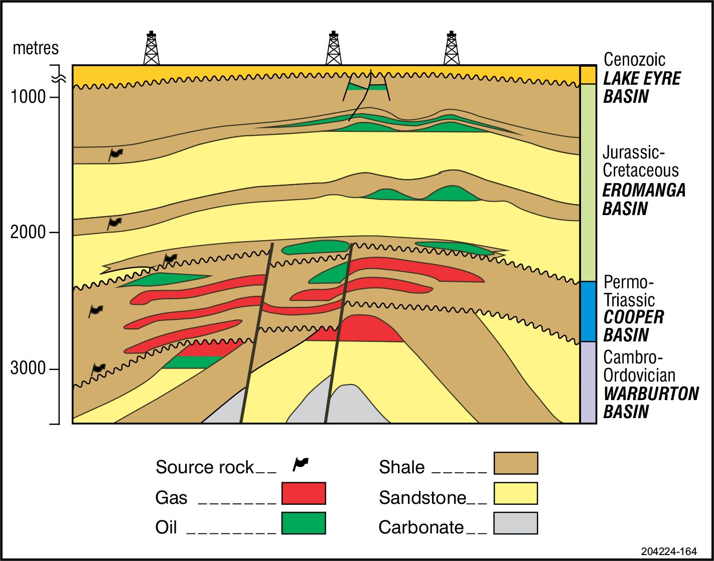
The intracratonic Cooper Basin represents a Late Carboniferous to Triassic depositional episode terminated at the end of the Middle Triassic with widespread compressional folding, regional uplift and erosion. It lies unconformably over early Palaeozoic sediments of the Warburton Basin and is overlain disconformably by the central Eromanga Basin. In the northern Patchawarra Trough, the Cooper Basin is locally overlain by the Late Triassic Cuddapan Formation. Total area exceeds 130 000 km2, of which ~35 000 km2 are in NE South Australia.
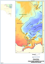
Three major troughs (Patchawarra, Nappamerri and Tenappera) are separated by structural ridges (Gidgealpa–Merrimelia–Innamincka (GMI) and Murteree) associated with the reactivation of NW-directed thrust faults in the underlying Warburton Basin.
The Cooper Basin has a complex architecture (Hall et al., 2015a), which has been largely influenced by structures in the underlying rocks of the Warburton Basin and older basement. The major tectonic episode separating the depositional episodes in the Warburton and Cooper basins is inferred to be the Late Ordovician–Carboniferous Alice Springs Orogeny.
Three major troughs, the Patchawarra, Nappamerri and Tenappera troughs, are separated by narrow sinuous structural ridges which are associated with the reactivation of northwest-directed thrust faults in the underlying Warburton Basin. These troughs contain up to 2500 m of Permo-Carboniferous to Triassic sedimentary fill overlain by as much as 1300 m of Jurassic to Tertiary cover.
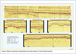
In addition to the major anticlinal and trough structures, the Cooper Basin hosts several smaller faults and folds (Figure 2). These faults recognised within the basin typically have small vertical displacements of <10 m, and are parallel to major fault-controlled ridges. Anticlines are also parallel, and are related to the major faults, indicating essentially sub-vertical reactivation of these basement structures (Gravestock et al., 1998). See Hall et al. (2015) for a comprehensive review of the architecture of the Cooper Basin.
The basin contains a number of non-marine depositional units within the Late Carboniferous to Late Permian Gidgealpa Group and Late Permian to Middle Triassic Nappamerri Group.
The Cooper Basin unconformably overlies flat lying to compressively deformed Cambro-Ordovician Warburton Basin strata and Carboniferous granitic intrusives. The unconformity is mapped as the Z seismic horizon. The oldest units are the Late Carboniferous to Early Permian Merrimelia Formation and Tirrawarra Sandstone which comprise terminoglacial and glaciofluvial systems deposited unconformably on a glacially scoured landscape. The Tirrawarra Sandstone represents braided fluvial to fan-delta deposits overlain by peat swamp and floodplain facies of the Patchawarra Formation. Locally (e.g. Pondrinie Field), Merrimelia aeolianite forms a major gas reservoir.
Two lacustrine shale units (Murteree and Roseneath shales) with intervening fluviodeltaic sediments (Epsilon and Daralingie formations) were deposited during a phase of continued subsidence. Early Permian uplift led to erosion of the Daralingie Formation and underlying units from basement highs. To the south west, in the Weena Trough area, recent drilling has clarified that the age equivalent sediments of the Patchawarra to Epsilon sequence changes character and becomes a thick interbedded sequence of sands, coals and shales of essentially fluvial character. The greatest coal thicknesses in the whole of the Cooper Basin are present in the Weena Trough area. In addition, a unit of possible lacustrine origin correlates in age and lithology to the Stuart Range Formation in the Arckaringa Basin, which has been interpreted as being deposited in a stratified fjord depositional model. Together these new insights suggest that the Weena Trough area was formed early in the history of the Cooper Basin, with local depocentres that filled over time (and possibly drained to the south and west in the Arckaringa Basin) until the main depocentre formed later in the Cooper Basin to the north (Murteree and Roseneath Lakes).
The Late Permian Toolachee Formation was deposited on the Daralingie unconformity surface and is overlain conformably by Late Permian to Middle Triassic Arrabury Formation (comprising the Callamurra, Paning and Wimma Sandstone members) and the Middle to early Late Triassic Tinchoo Formation.
The Cooper Basin is dominated by coal rich source rocks (clean coal, shaly coal and coaly shale). The organic matter characteristics of these coally source rocks are sufficiently different from conventional marine and lacustrine source rocks to require specifc assessment guidelines using Rock_Eval pyrolysis data. Most importantly, there is later onset (and a broader window) of oil and gas generation compared to marine/lacustrine shales with conventional type I – II kerogens. Wet gas may still be generated up to an Ro of 2% and dry ags up to Ro of 3.5%
Oils and condensates are typically medium to light (30–60o API) and paraffinic, with low to high wax contents. Most Permian oils in Permian reservoirs contain significant dissolved gas and show no evidence of water washing. Gas composition is closely related to maturity/depth with drier gas occurring towards basin depocentres although there is strong geological control on hydrocarbon composition. The Patchawarra Trough contains the bulk of the oil and wet gas reserves consistent with local source rocks being in the ‘oil window’, while central area of the hot Nappamerri Trough (40–50 ºC/km), underlain in part by granite, is over mature and contains mainly dry gas.
The Toolachee and Patchawarra Formations are the thickest, and richest source units, with some contribution from the Epsilon and Daralingie Formations. The coal measures and coally shales of these units are the principal hydrocarbon source rocks in the region and are dominated by Type II/ III to type III kerogens derived from higher plant assemblages with some liquids potential. The more coal rich facies have TOC> 10% and HIo ~200-260 mg HC/ g rock, and other non-shale source rocks have oil generation potential (HIo > 300 mg HC/ g rock). Shales however, have lower potential (TOC< 10% and HIo ~100-150 mg HC/ g rock) reflecting a more gas prone type III-IV kerogen.
The lacustrine early Permian Murteree and Roseneath shales have a lower source potential for conventional hydrocarbons with gas prone kerogen types III and IV dominating, and low TOC values averaging 3.9 percent in the Roseneath Shale and 2.4 percent in the Murteree Shale, and organic maturity is variable.
The Nappamerri Group has much more limited source potential with mean TOC of 1.3% and type III-IV gas prone kerogen. Thin, laterally discontinuous coals represent the best source rocks of the upper Nappamerri Group, whilst shales tend to be organically lean. The lower Nappamerri Group is coal-poor, contains kerogen that tends to be oxidised, and any source rocks are humic-rich and gas-prone (HIo 137 mg HC/ g rock).
Known generation of hydrocarbons in the Cooper Basin occurred primarily from kitchen areas within the Patchawarra and Nappamerri Troughs, where most of the drilling in the Cooper Basin has also been focused. Evidence from several thermal modelling studies, based on vitrinite reflectance data, apatite fission track annealing and argon dating, has indicated that there were multiple oil expulsion episodes in the Cooper Basin and the overlying Eromanga Basin. Minor amounts of hydrocarbons are considered to have been generated in the late Permian, particularly in the Nappamerri Trough, with the main generation event being in the mid Cretaceous, possibly related to a high heat flow event at about 90–85 Ma. The mid Cretaceous event likely resulted in the maximum expulsion from the Permian source rocks, as a result of high heat flow and maximum burial. The hydrocarbons would have been trapped initially within the Cooper Basin but may have migrated during later fault reactivation. In addition to this event, modelling suggests that minor generation also occurred within the last 5 million years. Additional oil expulsion has also been inferred to have occurred during the late Cenozoic.
Multi-zone high-sinuosity fluvial sandstones form poor (tight) to good quality conventional and unconventional reservoirs. Porosity and permeability varies signiciantly due to a combination of facies, and burial depth. Most porosity is not primary, and is either reduced by authigenic minerals (quartz overgrowths, siderite, and kaolin in shallower reservoirs, and illite, clinochlore, and pyrophyllite in deeper reservoirs) ore enhanced by dissolution of lithic and feldspar grains, or microporosity in kaolin. The main gas reservoirs occur primarily within the Patchawarra Formation (porosities up to 23.8%, average 10.5%; permeability up to 2500 mD) and Toolachee Formation (porosities up to 25.3%, average 12.4%; permeability up to 1995 mD). Shoreface and delta distributary sands of the Epsilon and Daralingie formations are also important reservoirs.
Oil is produced principally from low-sinuosity fluvial sands within the Tirrawarra Sandstone (porosities up to 18.8%, average 11.1%; permeability up to 329 mD). Towards the margin of the Cooper Basin, oil is also produced from the Patchawarra Formation and from fluvial channel sands in the Merrimelia Formation in the Malgoona Field. Tight sands have an average porosity of 6% and permeabilities in the microdarcy to millidarcy range. Tight sand thicknesses greater than 6 m (20 ft) present brittle and fracture stimulation targets.
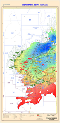
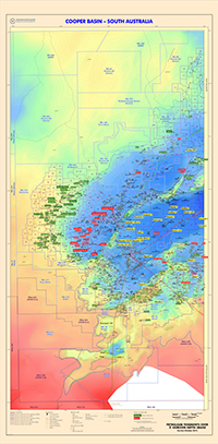
The Roseneath and Murteree Shales comprise potential unconventional reservoirs. The two shale units are thick, generally flat lying, and laterally extensive, comprising siltstones and siliceous (and sideritic in part) mudstones deposited in large and relatively deep freshwater lakes. These shales have low porosity and permeability and are brittle and fraccable. The Murteree Shale is widespread, reaching a maximum thickness of 86 m in the Nappamerri Trough (Figures 2.5 and 2.8) and thins to the north, reaching a maximum thickness of 35 m in the Patchawarra Trough (Figure 2.7). It is absent over crestal ridges. The Roseneath Shale reaches a maximum thickness of 105 m in the Tenappera Trough (Boucher, 2000) and is not present over most of the Patchawarra Trough (Figures 2.6 and 2.8).
Thick, laterally extensive, deep, high inertinite coal seams in both the Patchawarra Formation and the Toolachee Formation are potential unconventional reservoirs. The Patchawarra coal seams are deeper than 2000 m over most of the Cooper Basin. The floor for coal seam gas (CSG) production is generally considered to be 2000 m due to cleat closure and permeability reduction at these depths. However, scanning electron microscopy of VC50 coal core samples from Bindah 3 has shown that the coals contain significant mesoporosity1. The porosity is gas-filled and in the range 5–8% and is accompanied by permeability in the range 15–500 mD. The mesoporosity is a consequence of the high inertinite content of the coals (inertinite is derived from charred and biochemically altered plant cell wall material that generally remains intact during the carbonization process. The VC50 coal is thick and laterally continuous in parts of the Basin and may be suited to gas extraction using horizontal drilling and hydraulic stimulation techniques. Targeting natural fracture systems is likely to enhance production rates and optimise drainage.
Tight over-pressured gas reservoirs of the Patchawarra and Epsilon Formations are proven reservoirs, for example at Coonatie 1, Moomba Field, Burley 2 and more recently Holdfast 1 and Encounter 1.
The Callamurra Member of the Arrabury Formation is conventionally regarded as a regional seal, but nevertheless contains economic oil and gas reservoirs in some areas and is a leaky seal in others. Low-sinuosity fluvial sandstones of the Paning and Wimma Sandstone members form economic oil and gas reservoirs, and high-sinuosity fluvial sandstone of the Tinchoo Formation reservoirs oil. As yet, there have been no economic oil or gasfields discovered in the Cuddapan Formation in South Australia.
Intraformational shale and coal form local seals in the major reservoir units. Beneath the Daralingie unconformity are two important early Permian regional seals — the Roseneath and Murteree shales. The Roseneath Shale is the top seal of the Epsilon Formation, and the Murteree Shale seals the Patchawarra Formation. A younger regional seal is provided by the Triassic Arrabury Formation.
1 Micropores with diameters between 2 and 50 nanometers (10-9 metres).
Most discovered fields in the Cooper Basin comprise multiple gas pools (and/or oil) stacked in coaxial Permian–Mesozoic anticlinal and faulted anticlinal closures and may occur from as low as the Tirrawarra Formation to as high as the Coorikiana Sandstone depending on the extent of regional seals. The pools in the Patchawarra, Epsilon and Toolachee, often are partially stratigraphic, and successful wells are dependent on intersection of high sinuosity channel facies. Fraccing is common practice to improve recoveries from highly variable permeability sandstones.
Locally, Permian oil has migrated into Warburton Basin reservoirs on the basin margin and gas has migrated into fractured Ordovician reservoirs fringing the Allunga Trough forming a potential exploration play.
There have been few documented examples of purely stratigraphic discoveries in the Cooper Basin, but potential remains high for discoveries in stratigraphic (especially in shoreface type sands in the Epsilon Formation) and sub-unconformity traps (especially where the Permian sediments are truncated by the overlying Eromanga Basin succession).
Economic oil and gas are reservoired in the Nappamerri Group, paradoxically regarded as a regional seal to the Cooper Basin.
Thick coals and organic rich shales in the Early Permian succession are capable of generating enormous hydrocarbon volumes. The total gas generative potential of the Cooper Basin source rocks has been estimated to be between 4,027 tcf to 8,055 tcf . This compares to current known conventional reserves of around 10 tcf.
Until recent years the Cooper Basin was considered a mature petroleum province, with remaining potential for large discoveries in stratigraphic and sub-unconformity traps. However the unconventional gas revolution has changed the perception of the Cooper Basin, with potential unconventional gas resources far exceeding the conventional gas production from the basin to date.
Explorers targeting basin-centred gas, deep coal gas and shale gas have been encouraged by results to date and exploration programs are progressing to pilot project status. Santos estimates for the South Australian Cooper Basin Joint Venture licences range from a low of 22 trillion cubic feet to a high of 187 trillion cubic feet raw recoverable gas for unconventional gas resources.
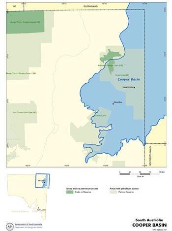
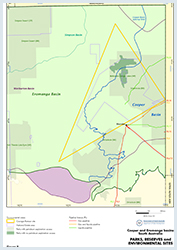
The Innamincka and Strzelecki Regional Reserves occur over the Cooper Basin. Exploration and production are permitted. Within the Innamincka Regional Reserve a special management zone exists that excludes access for petroleum activities. At the core of this zone is the Malkumba–Coongie Lakes National Park. Other conditional access zones exist around the Coongie Lakes area limiting access for petroleum or mineral exploration or production. Much of the current petroleum produced from the Cooper Basin originates from within the Innamincka Regional Reserve.
Parts of the Cooper Basin are listed as wetlands of international significance under the Ramsar Convention (the 1971 Convention on Wetlands of International Importance). The Coongie Lakes and part of the Coopers Creek system have also been included in the Register of the National Estate.
The initial 2001 right to negotiate (RTN) agreements in the Cooper Basin for the CO-98 PEL application areas were groundbreaking in Australia as the first conjunctive agreements (covering exploration and production) that provide certainty in enabling any explorer, the Aboriginal parties, and the state being able to benefit from any commercial discoveries made.
Further agreements were settled for the CO-99 and CO-2000, CO-2003 and CO-2005 acreage releases with the CO-2003 area located adjacent to the Coongie Lakes region. The RTN process is likely to be instigated in late 2013 relative to the successful application for the most recent CO-2012 release block in the Cooper Basin.
These agreements establish processes to protect Aboriginal heritage before and during field operations, and to provide payments for the interference with the enjoyment of the native title rights of the claimants. All of these agreements are conjunctive, and cover all petroleum licence activities from exploration through to development and production.
In 2006, negotiations commenced to develop a petroleum conjunctive Indigenous land use agreement (ILUA) for the regions already covered with land access agreements resulting from earlier RTN proceedings. These negotiations involve the Aboriginal Legal Rights Movement (now South Australian Native Title Services Ltd), the three native title parties already familiar with the RTN process, the South Australian Government, and petroleum exploration and production company representatives (through the South Australian Chamber of Mines and Energy).
The draft framework agreement established through the 2006 negotiations formed the basis for the first conjunctive ILUA in Australia in a proven petroleum province which was concluded in February 2007 with the Yandruwandha / Yawarrawarrka native title claimants over a major portion of the South Australian Cooper Basin. A second conjunctive petroleum ILUA was concluded in June 2011 with the Wangkangurru/Yarluyandi native title claimants over lands including the northern part of the South Australian Cooper Basin. The availability of these ILUA’s provide greater certainty for explorers and expedite the grant of PELs in a way that remains fair to native title claimants and sustainable in relation to exploration and production investment.
The application of conjunctive ILUAs enables access to land more quickly and with lower transaction costs than serial RTN proceedings. The successful implementation of conjunctive ILUAs for Cooper Basin petroleum exploration and production serves as a model for analogous agreements elsewhere in the state.
In summary, conjunctive ILUAs are proposed as an evolutionary, additional, alternative to the RTN process already working comparatively well in South Australia. Indeed, conjunctive ILUAs are an attractive incentive to achieve competitive work program bids, with explorers knowing the terms of land access prior to lodging bids.
Altmann MJ and Gordon HM, 2004. Oil on the Patchawarra Flank - some implications from the Sellicks and Christies oil discoveries. In: Boult PJ, Johns DR and Lang SC eds, PESA’s Eastern Australasian Basin Symposium II, Adelaide 2004. Petroleum Exploration Society of Australia. Special Publication, pp. 29-34.
Boucher RK, 2001a. Warburton Basin GIS data atlas. South Australia. Department of Primary Industries and Resources. Report Book, 2001/00019.
Boucher RK, 2001b. Analysis of seals of the Roseneath and Murteree Shales, Cooper Basin, South Australia. South Australia. Department of Primary Industries and Resources. Report Book, 2001/00015.
Flottmann T, Campagna DJ, Hillis R and Warner D, 2004. Horizontal microfractures and core discing in sandstone reservoirs, Cooper Basin, Australia. In: Boult, P.J., Johns, D.R. and Lang, S.C. (Eds), PESA’s Eastern Australasian Basin Symposium II, Adelaide 2004. Petroleum Exploration Society of Australia. Special Publication, pp. 689-694.
Geoscience Australia, Cooper Basin Prospectivity Study
Gravestock DI, Hibburt JE and Drexel JF eds, 1998. The petroleum geology of South Australia. Volume 4: Cooper Basin. South Australia. Department of Primary Industries and Resources. Petroleum Geology of South Australia Series.
Greenstreet, C. 2015 From play to production: the Cooper unconventional story—20 years in the making.
Extended Abstract APPEA 2015
Hall, L., Hill, T., Wang, L., Edwards, D., Kuske, T., Troup, A., Boreham, C. 2015 Unconventional gas prospectivity of the Cooper Basin Extended Abstract APPEA 2015.
Hall, L.S., Hill, A., Troup, A., Korsch, R., Radke, B., Nicoll, R.S., Palu, T., Wang, L. & Stacey, A. 2015a. Cooper Basin architecture and lithofacies: regional hydrocarbon prospectivity of the Cooper Basin, Part 1. Record 2015/31. Geoscience Australia, Canberra.
Hall, L.S., Boreham, C.J., Edwards, D.S., Palu, T.J., Buckler, T., Hill, A.J. & Troup, A. 2016a. Cooper Basin Source Rock Geochemistry: Regional Hydrocarbon Prospectivity of the Cooper Basin, Part 2. Record 2016/06. Geoscience Australia, Canberra.
Hall, L.S., Palu, T.J., Murray, A.P., Boreham, C.J., Edwards, D.S., Hill, A.J. & Troup, A. 2016h. Cooper Basin Petroleum Systems Analysis: Regional Hydrocarbon Prospectivity of the Cooper Basin, Part 3. Record 2016/29. Geoscience Australia, Canberra.
Kramer L, McKirdy DM, Arouri KR, Schwark L and Leythaeuser D, 2004. Constraints on the hydrocarbon charge history of sandstone reservoirs in the Strzelecki Field, Eromanga Basin, South Australia. In: Boult PJ, Johns DR and Lang SC eds, PESA’s Eastern Australasian Basin Symposium II, Adelaide 2004. Petroleum Exploration Society of Australia. Special Publication, pp. 589-602.
McDonough R, 1997. Economics of gas gathering and processing in the Cooper Basin. Revised edn. South Australia. Department of Primary Industries and Resources. Report Book, 97/34.
McKirdy DM, Arouri KR and Kramer L, 2005. Conditions and effects of hydrocarbon fluid flow in the subsurface of the Cooper and Eromanga Basins. University of Adelaide report on ARC SPIRT Project C39943025 for PIRSA and Santos Ltd. South Australia. Department of Primary Industries and Resources. Report Book, 2005/00002.
Nakanishi T and Lang SC, 2002. Constructing a portfolio of stratigraphic traps in fluvial-lacustrine successions, Cooper–Eromanga Basin. APPEA Journal, 42(1): 65-82.
O’Neil BJ, ed, 1989. The Cooper and Eromanga Basins, Australia. Proceedings of the Cooper and Eromanga Basins Conference, Adelaide, 1989. Petroleum Exploration Society of Australia, Society of Petroleum Engineers, Australian Society of Exploration Geophysicists (SA Branches).
Schenk CJ, Tennyson ME, Mercier TJ, Klett TR, Finn TM, Le PA, Brownfield ME, Gaswirth SB, Marra KR, Hawkins SJ, Leathers-Miller HM and Pitman JK, 2016. Assessment of undiscovered conventional oil and gas resources of the Cooper and Eromanga Basins, Australia, 2016. USGS Fact Sheet 2016-3028.
Schenk, C.J., Tennyson, M.E., Mercier, T.J., Klett, T.R., Finn, T.M., Le, P.A., Brownfield, M.E., Gaswirth, S.B., Marra, K.R., Hawkins, S.J., and Leathers-Miller, H.M., 2016, Assessment of continuous oil and gas resources of the Cooper Basin, Australia, 2016: U.S. Geological Survey Fact Sheet 2016–3050, 2 p.
Schenk, C.J., 2019, USGS National and Global Oil and Gas Assessment Project-Eromanga Basin Province, Australia, Cooper Basin Continuous Assessment Unit Boundaries and Input Data: U.S. Geological Survey data release.
Underschultz J and Boult P, 2004. Top seal and reservoir continuity: hydrodynamic evaluation of the Hutton-Birkhead Reservoir, Gidgealpa Oilfield. In: Boult PJ, Johns DR and Lang SC, eds, PESA’s Eastern Australasian Basin Symposium II, Adelaide 2004. Petroleum Exploration Society of Australia. Special Publication, pp. 473-482.