
On this page
 The Arrowie Basin is a Neoproterozoic; Early – mid Late Cambrian basin.
Arrowie Basin comprises four major structural components:
- thin flat-lying cover on the Stuart Shelf;
- faulted slices of unknown thickness in the structurally complex Torrens Hinge Zone between the Stuart Shelf and Flinders Ranges;
- thick but dispersed outcrops in the ranges; and
- synclinorium bisected by the Proterozoic Benagerie Ridge between the Flinders and Barrier ranges in western New South Wales.
Summary
| Age | Neoproterozoic; Early – mid Late Cambrian. |
|---|---|
| Area in South Australia |
Early – mid Late Cambrian. Area in South Australia 43 000 km2 (16 600 sq. miles) subsurface, 12 000 km2 (4630 sq. miles) outcrop. |
| Exploration Well Density | 1 well per 2047 km2 (1 well per 790 sq. miles) |
| Success ratio | no discoveries |
| Depth to target zone | <1000–1700 m |
| Thickness | 1000–3500 m |
| Hydrocarbon shows | Oil shows in Wilkatana wells; trace free oil (Moodlatana Formation), slightly gas-cut, very saline water (Wirrealpa Limestone) in Moorowie 1; gas shows from water bores in Moorowie and Yalkalpo synclines (anecdotal). Pyrobitumen recorded in deep mineral exploration hole (TDH001 – Torrens Hinge Zone). |
| First commercial discovery | None |
| Identified reserves | Nil |
| Undiscovered resources (50%) | Not determined |
| Production | Nil |
| Basin type | Extensional, closed by subsequent collision |
| Depositional setting | Marine shelf-ramp and shelf-basin complex; reefs |
| Reservoirs | Dolomite, limestone karst, sandstone |
| Regional structure | AAnticlines; some detached, others diapiric; local thrust-wrench complexes with pop-up structures |
| Seals | Micritic limestone, redbeds, anhydrite |
| Source rocks | Micritic limestone, shale. |
| Number of wells | 21 petroleum (>500m), 16 stratigraphic (>100m), 50 geothermal, ~11 deep mineral holes (>300m), 18 holes in total <500m. |
| Seismic line km | 3693 2D |
Prospectivity
Adelaide Rift Complex
South Australia has extensive deposits of thick Neoproterozoic (Adelaidean) sedimentary and volcanic rocks which were deposited on the Palaeo-Pacific margin of the Rodinia Supercontinent. Preserved Neoproterozoic deposits extend from Fleurieu Peninsula, south of Adelaide, to the Musgrave Ranges in NW South Australia. The thickest sections were deposited in complex rift basins and outcrop in the Flinders and Mt Lofty ranges. The Officer Basin consists of equivalent but thinner deposits which accumulated in the Centralian Superbasin.
The central Adelaide Rift Complex is exposed in the central part of the Flinders Ranges and occurs in subcrop where it is overlain by the Arrowie Basin and Mesozoic or Tertiary strata in the Lake Frome and Lake Torrens regions. Sediments were disrupted by contemporaneous, episodic emplacement of salt diapirs, which form the cores of broad domal structures in the region. The central Adelaide Rift Complex was compressively deformed and faulted during the Middle to Late Cambrian Delamerian Orogeny. Sediments were not subjected to high heat flow and are unmetamorphosed in this region. Granitic intrusives are restricted to the Moorowie Syncline.
Arrowie Basin
Arrowie Basin carbonates and clastics were deposited in tropical latitudes on the eastern seaboard of the Gawler Craton from the Early to mid Late Cambrian. These deposits disconformably overlie Neoproterozoic strata of the Adelaide Geosyncline.
The Arrowie Basin comprises four major structural components: thin flat-lying cover on the Stuart Shelf; faulted slices of unknown thickness in the structurally complex Torrens Hinge Zone between the Stuart Shelf and Flinders Ranges; thick but dispersed outcrops in the ranges; and a synclinorium bisected by the Proterozoic Benagerie Ridge between the Flinders and Barrier ranges in western New South Wales.
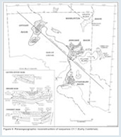
More than 5 km of sediment accumulated in the central Arrowie Basin, now exposed in synclines in the Flinders Ranges. Thinner Cambrian cover (~300 m) on the Stuart Shelf is situated west of a complex of N–S striking faults (Torrens Hinge Zone). In the eastern Arrowie Basin, up to 2300 m of Cambrian strata occur at depth in the Moorowie and Yalkalpo synclines which are separated by a structurally elevated Proterozoic Benagerie Ridge. Total subcrop area east and west of the ranges with hydrocarbon potential, is ~43 000 km2.
Depositional continuity between the Arrowie Basin and the eastern Warburton Basin to the north was severed late in the Early Cambrian by uplift which preceded a possible microcontinental collision in the Middle and Late Cambrian; the collision site being the Wonominta area in western New South Wales. Depositional links with the Stansbury Basin to the south may have continued until the Middle to Late Cambrian collisional Delamerian Orogeny, but evidence has long since disappeared. The original area of sedimentation was thus quite different from the remnant now preserved.
Structural style in the Torrens Hinge Zone, west of the Flinders Ranges, is poorly known due to an absence of useful seismic coverage. Judging by the >1000 m depth difference to the top of Wilkawillina Limestone in existing wells, fault displacements are large and faults are likely to be compressive. On structural ridges, as at Old Motpena 1, the Lake Frome Group (1200+ m thick at Brachina Gorge), has been completely eroded. Gravity interpretations also indicate major faults at shallow depth in the Motpena area. The fold pattern of domes and basins mapped in outcrops of the Flinders Ranges does not convey the extent of thrust faulting, particularly on the eastern and western margins of the ranges.
The Yalkalpo Syncline east of the Benagerie Ridge appears to be a simple north-plunging depression. The Moorowie Syncline is terminated to the north by faulted basement; beneath Lake Frome a major N–S wrench complex (Poontana Fracture Zone) extends through the syncline.
Adelaide Rift Complex
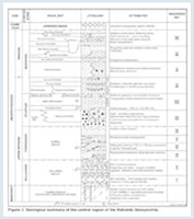
The succession consists of sandstone, siltstone, shale and limestone, deposited in a predominantly shallow marine setting.
Arrowie Basin
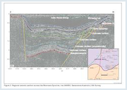
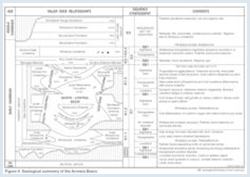
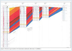
Three sequence sets (supersequences) ª1, ª2 and ª3 constitute the Cambrian Arrowie Basin fill. The lowest two, subdivided into six third order sequences (‘Uratanna’ sequence, ª1.1, ª1.2, ª1.3, ª2.1, ª2.2), have hydrocarbon potential. A seismic section and a wireline log correlation across the Moorowie Syncline are shown in figures.
Above the basal clastic Uratanna sequence, sequences ª1.1–ª1.3 (Hawker Group) are dominated by carbonates ranging from an initial shelf–ramp complex (ª.1.1) to a reef-rimmed platform passing north to a deep marine basin. Distinct phases of reef growth, platform exposure and karsting, onlap and offlap of slope sediments, and a final progradational–aggradational phase of basin infilling are recorded. The uppermost sequence ª1.3 is punctuated by episodes of volcanism and tectonic activity, the latter eroding channels through the reef complex and shedding sediment down the palaeoslope to the north.
The Benagerie Ridge was uplifted at the same time, effectively separating the Moorowie and Yalkalpo synclines. Widespread regression in upper ª1.3 is reflected by development of evaporitic sabkhas characterised by stromatolitic dolostone and gypsum deposits. The evaporite facies is preserved as an 8 m thick anhydrite cap in Moorowie 1 at a depth of 2180 m.
Sequences ª2.1 and ª2.2 were deposited under the waning influence of base-level readjustments following the tectono-volcanic episode known as the Kangarooian Movements. Billy Creek Formation redbeds were succeeded by a transgressive–regressive phase of carbonate deposition (Wirrealpa Limestone) that is also recorded in contemporary or slightly younger deposits across Australia (e.g. Warburton, Amadeus, Georgina, Daly, Bonaparte basins).
The third sequence set ª3 is represented by redbeds of the Lake Frome Group. This is a package of arkose with minor carbonate which in general becomes more quartzose and coarser grained up-section. Sequences have not yet been differentiated in this essentially deltaic to shallow subtidal succession. Fluvial influence is evident in upper beds of the Grindstone Range Sandstone which represents the youngest Cambrian exposure in the Arrowie Basin. Age is probably no younger than early Late Cambrian.
During the 1960s and 1970s the Flinders Ranges, the exposed ‘backbone’ of the Arrowie Basin, were mapped in detail but petroleum exploration commenced in 1956 with the Wilkatana drilling program by Santos. Thirteen of the 20 wells intersected Early Cambrian carbonates and paraffinic oil shows were reported from several of these (note: the Wilkatana drillholes have been counted as ‘one well’ in the statistics panel).
Subsequent drillholes in the Torrens Hinge Zone west of the Flinders Ranges (Motpena 1, Edeowie 1) terminated in redbeds at about 1 km depth but above the carbonates, with the exceptions of Yarrah 1 (drilled in 1982 to twin Wilkatana 1) and Old Motpena 1 (drilled in 1983). These two wells reached Cambrian carbonates at 149 m and 315 m depth respectively. Wells Blinman 1 and 2 were drilled in 1990–91 for petroleum within and adjacent to a major diapiric structure in the central Flinders Ranges. Traces of gas were recorded from fractures in the Proterozoic Tapley Hill Formation in Blinman 2, and Blinman 1 terminated in a large diapiric raft with no shows.
The region east of the Flinders Ranges has been partly explored seismically, and four wells have been drilled: Lake Frome 1–3 in 1968 and Moorowie 1 in 1983. None of these holes intersected the principal carbonate reservoir at depth.
Seismic surveys are chiefly of regional and ‘pre-detail’ coverage, comprising Vibroseis and dynamite or cord. Several prospects have been delineated by the most recent 1987 survey.
Exploration for Geothermal Energy in the Arrowie Basin has resulted in a resurgence in activity in both the western and eastern Arrowie Basin with 13 wells being drilled in the Torrens Hinge Zone and 24 wells drilled in the Moorowie Syncline area since 2005. In this same period, 2 seismic surveys have been acquired in the Torrens Hinge Zone and Stuart Shelf, and a further 2 surveys shot in the Moorowie Syncline.
Geoscience Australia tagged the southern Arrowie Basin and northwestern Torrens Hinge Zone with the 2003–04 Curnamona Transects - L164 Survey. In early 2009, Geoscience Australia acquired another seismic transect linking the Gawler Craton, Arrowie Basin and Curnamona Province, as part of the Onshore Energy Security Project.
Adelaide Rift Complex
The hydrocarbon potential of the central Adelaide Rift Complex is poorly understood. Potential source rocks include the Skillogalee Dolomite and Tindelpina Shale.
Arrowie Basin
There is little information from the subsurface as few wells have been drilled. Deep near-surface weathering gives a perception of organically lean, gas-prone Type III kerogen. Sequence ª1.1 organic geochemical analyses are mainly of shallow marine shelf carbonates with resultant low TOC values. Analyses of sequence ª1.2 samples, mostly nodular and flaggy Mernmerna Formation, generally yield low TOC values of 0.2% or less. Neither the Midwerta Shale nor Nepabunna Siltstone nor highstand Mernmerna facies have been sampled at depth below the zone of weathering.
The few analyses in sequence ª1.3 are from BWM1A 1 in the Moorowie Syncline (a uranium drillhole) and from zinc exploration drillhole BRD 2 in the Flinders Ranges. TOC content in three of the four samples ranged from 0.79 to 1.43%. These are from argillaceous Mernmerna Formation and Oraparinna Shale in the late transgressive and highstand tracts.
Input of fine-grained siliciclastics in highstand tracts may be conducive to organic matter preservation; McKirdy (1994) has noted that sterane and triterpane biomarkers in Wilkatana 1 crude oil samples suggest argillaceous rather than carbonate source rocks.
Adelaide Rift Complex
Potential reservoirs include shallow marine sandstone and carbonate, sealed by transgressive marine shale. In weathered outcrop many potential reservoirs are tight; development of fracture systems and secondary porosity in the subsurface would enhance their reservoir potential.
Arrowie Basin
Palaeogeographic reconstructions may help locate potential reservoirs by identifying areas exposed in lowstands when porosity and permeability were enhanced. Diagenesis and burial history determine final reservoir characteristics. Fracture networks are likely to be critical in determining deliverability.
Several hundred metres of sequence ª1.1 grainstone were deposited on the shelf across the south–central Arrowie Basin. By virtue of their original grainy fabric and high initial strength, such carbonates have high porosity and permeability, and are prone to early cementation and later leaching.
Sea-level fall at the ª1.2 lowstand exposed possibly 20 000 km2 of shelf carbonates to subaerial exposure. Despite subsequent transgression, parts of the shelf remained exposed for several million years. The Wilkawillina Limestone is strongly recrystallised and partly dolomitised but the original fabric is discernible. Porosity is mainly vuggy and inter-crystalline. Solution breccia zones are thin and vugs are connected by hairline fractures.
Highstand clastics such as the Narina Greywacke and Mernmerna Formation grainflows and channel sands are worth considering as possible reservoirs. Their northward progradational nature guarantees widespread distribution in that direction; they overlie possible source rocks of the transgressive tract and underlie a regional seal making them potential drilling targets.
Sandstone beds also occur in the Billy Creek Formation in the Moorowie and Yalkalpo synclines and secondary porosity may occur in altered ooid grainstones of the Wirrealpa Limestone. In the latter, porosity up to 11% and permeability up to 1.8 mD have been measured from core in Moorowie 1. Thin sands with trace oil fluorescence have also been recorded from the Moodlatana Formation of the Lake Frome Group. Younger sandstones however lack a regional seal.
Regional seals consist mainly of redbeds, micritic carbonate and evaporite. Evaporites were widespread in the upper highstand tract of sequence ª1.3 and although only pseudomorphs are found in outcrop, an 8 m thick anhydrite bed in Moorowie 1 confirms their sub-surface preservation. Desiccated salinas and algal mudflats spread from the Stuart Shelf to the Benagerie Ridge forming a regional seal. The widespread Wirrealpa Limestone is a potential reservoir–seal couplet where oolite (reservoir) is overlain by micrite.
Given the relatively under explored nature of the basin, potential plays have yet to be firmly established. Several prospects have been identified along the Poontana Fracture Zone.
There is no estimate of undiscovered resources.
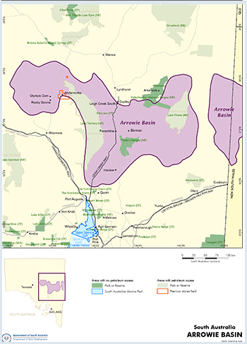
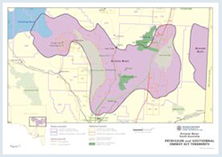
The Arrowie Basin is covered by Lake Torrens, Lake Frome, Ikara–Flinders Ranges and Vulkathunha–Gammon Ranges national parks. Exploration is only allowed in Lake Torrens and Lake Frome NP.
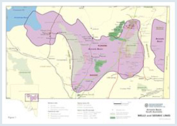
Licence activity in the previous year is discussed in the annual exploration and production review, and figure 7 shows the licence status at the time of publication. For further information on holders of petroleum tenements in South Australia see the Quarterly Information Sheet (P01).
Broomfield IE, 1997. Petroleum potential of the Moorowie Sub-basin, eastern Arrowie Basin, South Australia. University of South Australia. BAppSc (Hons) thesis (unpublished).
Cooper AMcG, 1991. Late Proterozoic hydrocarbon potential and its association with diapirism in Blinman No. 2, central Flinders Ranges, South Australia. University of Adelaide. National Centre for Petroleum Geology and Geophysics. BSc (Hons) thesis (unpublished).
Gravestock DI and Hibburt JE, 1991. Sequence stratigraphy of the eastern Officer and Arrowie basins: a framework for Cambrian oil search. APEA Journal, 31:177-190.
Jago JB, Sun X and Zang W, 2002. Correlation within early Palaeozoic basins of eastern South Australia. South Australia. Department of Primary Industries and Resources. Report Book, 2002/00033.
James NP and Gravestock DI, 1990. Lower Cambrian shelf and shelf margin buildups, Flinders Ranges, South Australia. Sedimentology, 37(3):455-480.
McKirdy DM, 1994. Biomarker geochemistry of the Early Cambrian oil show in Wilkatana-1: implications for oil generation in the Arrowie and Stansbury basins. PESA Journal, 22:3-17.
McLean B, 1999. Geophysical investigations in the Moorowie Syncline, Arrowie Basin, South Australia. Adelaide University. National Centre for Petroleum Geology and Geophysics. MSc thesis (unpublished).
Teasdale J, Pryer L, Etheridge M, Romine, K, Stuart-Smith P, Cowan J, Loutit T, Vizy J and Henley P, 2001. Eastern Arrowie Basin SEEBASE Project. SRK Consulting report, SRK Project Code: PI12. South Australia. Department of Primary Industries and Resources. Open file Envelope, 9889.
Youngs BC, 1977. The sedimentology of the Cambrian Wirrealpa and Aroona Creek Limestones. South Australia. Geological Survey. Bulletin, 47.
Youngs BC and Moorcroft E, 1982. The petroleum potential of the eastern Arrowie Basin and Frome Embayment. APEA Journal, 22:82-101.
Zang W, 2002. Sequence analysis and petroleum potential in the Arrowie Basin, South Australia. South Australia. Department of Primary Industries and Resources. Report Book, 2002/00024.
Zang W, Jago JB, Alexander EM and Paraschivoiu E, 2004. A review of basin evolution, sequence analysis and petroleum potential of the frontier Arrowie Basin, South Australia. In: Boult PJ, Johns DR and Lang SC eds, PESA’s Eastern Australasian Basin Symposium II, Adelaide 2004. Petroleum Exploration Society of Australia. Special Publication, pp. 243-256.