
On this page
The Stansbury Basin is an Early - Middle Cambrian basin.
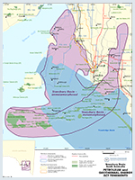
The prospective area of the Stansbury Basin lies mainly beneath Gulf St Vincent and southern Yorke Peninsula. A basin-in-a-box (well and seismic) data package is available for the Stansbury Basin.
Summary
| Age | Early - Middle Cambrian |
|---|---|
| Area in South Australia | 15 000 km2 (5790 sq miles) |
| Depth to target zone | 600-2500m |
| Thickness | Up to 1500m |
| Hydrocarbon shows | Trace gas on DST, trace oil reported in core |
| First commercial discovery | None |
| Identified reserves | Nil |
| Undiscovered resources (50%) | Not determined |
| Production | Nil |
| Basin type | Extensional; deformed by marginal collision |
| Depositional setting | Marine shelf-ramp-basin |
| Reservoirs | Dolomite, sandstone |
| Regional structure | Anticlines on stable nucleas boredered by thrust-zones |
| Seals | Redbeds, micritic limestone, evaporite |
| Source rocks | Marine black shale |
| Number of wells | 6 petroleum, 5 stratigraphic, >20 deep mineral drillholes |
| Seismic line km | 4753 2D offshore, 625 2D onshore |

Prospectivity
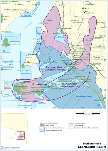
The prospective area of the Stansbury Basin lies mainly beneath Gulf St Vincent and southern Yorke Peninsula. The sedimentary section crops out on northern Yorke Peninsula, Fleurieu Peninsula and the north coast of Kangaroo Island. To the east and south equivalent rocks are deformed, metamorphosed and intruded by granite.
In the western Stansbury Basin, Early Cambrian basal sand and marine shelf carbonate onlap the Gawler Craton and pass east into a ramp–basin setting which may have evolved into a foreland trough (Kanmantoo Trough). Structures beneath Gulf St Vincent are chiefly broad, low-amplitude anticlines.
On Yorke Peninsula, where previous petroleum exploration was centred, drilling was mainly in complex fault-block mosaics associated with the Pine Point Fault Zone. This zone was tectonically active during the Early Cambrian resulting in ‘bald-heading’ of some structures, but the principal deformation (collision orogeny) took place in the Middle–Late Cambrian on the eastern and southern structural margins of the basin. The original depositional area was much more extensive to the east and south, and is explored as a mineral province because of its high metamorphic grade and structural complexity.
Glacial erosion in the Late Carboniferous was followed by deposition of up to 2000 m of Permian (Troubridge Basin) and Tertiary sediments. A final compressional event in Tertiary to Recent time reactivated many Delamerian reverse faults along the platform margin.
On Kangaroo Island, little exploration for oil and gas has occurred - one exploration well was drilled in the 1920s, Investigator 1 and 2 stratigraphic research wells were drilled by the Department in the 1990s and there have been no seismic surveys. LK Ward, the Government Geologist recorded that American Beach Oil Bore 1 was drilled in 1921 at a location identified by a diviner to test a supposed seepage of oil on the beach at Eastern Cove which occurred in June 1920. It is likely that the ‘seepage’ was a natural asphaltite stranding which occur on Australia’s southern margin including Kangaroo Island, as described in a paper by Hall et al (2013).
On Yorke Peninsula, dubious oil shows were reported by entrepreneurial drilling syndicates in the 1930s. Bona fide oil traces were reported from Minlaton 1 stratigraphic hole drilled in 1956–57, which confirmed an Early Cambrian section greater than 800 m thick, but no samples remain for analysis.
In 1964 Beach Petroleum commenced a decade of systematic exploration with airborne magnetic and gravity surveys, seismic and drilling. Three deep exploration wells (Stansbury Town 1, Stansbury West 1, Edithburgh 1) were drilled and logged, with traces of gas accompanying highly saline water on drillstem test in Stansbury West 1. Seismic surveys of the day were of poor quality (474 km single-fold onshore; 925 km mostly single-fold offshore), with consequent uncertain siting of exploration wells on structural trends. Several stratigraphic wells were drilled by Beach, including Troubridge Island 1 on an offshore sandbank, which terminated in the Permian.
Mineral exploration on central and northern Yorke Peninsula in the 1970s and 1980s resulted in the acquisition of further gravity and magnetic data, and numerous wells were drilled (principally by Aquitaine and BHP) for base metals, uranium and dolomite. Apart from copper mined in Proterozoic rocks, no ore bodies have been discovered. In 1982–83, Pan Pacific Petroleum acquired 59 km of 24-fold Vibroseis and sampled drillcores for source rock analysis, demonstrating that available samples on Yorke Peninsula are mainly organically lean (TOC <0.5%) and gas prone.
A 1985 marine seismic survey in southern Gulf St Vincent (303 km, 60-fold) resulted in good structural definition of the Permian and Cambrian sections.
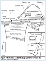
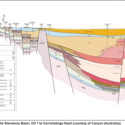
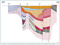
PEL 53 was granted in 1990 to Wagner and Brown (Aust.). Exploration included 1109 km of seismic acquisition (offshore), seismic reprocessing, tectonic studies and source rock geochemistry. PEL 59, adjacent, was also granted to Wagner and Brown in 1993, and 63 km of marine seismic were recorded. Two wells (Enchilada 1, Frijole 1) were drilled to Cambrian targets in 1998, but without success. A cross-section through these wells is shown in Figure 3.
PEL 73 was granted to David Schuette in 2000. Gravestock 1 exploration well was drilled in February–March 2007 by Austin Exploration in PEL 73 in the Stansbury Basin, but was plugged and abandoned. The well was named to honour the late Dr David Gravestock — former Principal Petroleum Geologist for the South Australian Department of Mines and Energy. Dr Gravestock played a leading role in researching the state’s petroleum exploration potential, geology and Cambrian biostratigraphy over many years, until his untimely death in 1999. PEL 73 was surrendered on 2011.
In the Adelaide region Reg Sprigg’s company Geosurveys acquired seismic on the coast and drilled Grange 1 in 1962; there has been no oil and gas exploration activity since.
The Stansbury Basin succession on Yorke and Fleurieu Peninsulas forms two sequence sets (Є1, Є2), each of which can be separated into depositional sequences also recognised in the Arrowie Basin. Correlation of the very thick (2500 m) section on the north coast of Kangaroo Island appears on present evidence to represent parts of sequences Є1.2–Є2.1 in separate thrust fault slivers.
Transgressive clastics of the basal Cambrian Uratanna sequence onlapped the Gawler Craton from the SE (Mt Terrible Formation), culminating in coarse-grained, late highstand deposits on Yorke Peninsula (Winulta Formation). They were followed by shallow subtidal to supratidal, often dolomitised, oolite shoals, stromatolites and fenestral boundstones (most of Kulpara and Wangkonda formations). The upper lowstand wedge on Fleurieu Peninsula is characterised by shallow subtidal sandy dune ridges and bioturbated fine-grained interdune siliciclastics of the basal Sellick Hill Formation.
Transgression in sequence Є1.1 was characterised by shallow marine carbonates north of a hinge zone across central Yorke Peninsula. To the south and SE however, deeper water lime mud (lower Parara) and ribbon limestone (most of remaining Sellick Hill Formation) accumulated. Rapid marine regression led to subaerial exposure on northern Yorke Peninsula. Bioherms of the Fork Tree Limestone grew on the subtidal outer ramp during lowstand. With renewed transgression, mottled lime mud of the Parara and deep basinal shale (Heatherdale Shale) accumulated under fluctuating oxic–anoxic conditions. Episodes of volcanism are recorded by thin tuffs, one of which has yielded an age of 5264 Ma. On Yorke Peninsula, the Koolywurtie Member (upper Parara) is an archaeocyath–calcimicrobe reef complex which extended at least from Ardrossan to Edithburgh.
Tectonic activity (Kangarooian Movements) was accompanied by accumulation of alluvial and fan-delta conglomerates in the lowstand redbeds of Є2.1. Movement on the Pine Point Fault Zone, and southern extensions near Kangaroo Island, stripped portions of previously deposited carbonates (Kulpara, Parara, Koolywurtie) and locally exposed crystalline basement. These form the bulk of clasts in the Minlaton Formation on Yorke Peninsula and White Point Conglomerate on Kangaroo Island.
Differential uplift adjacent to the Gawler Craton was accompanied by foundering of the sea floor and initiation of the Kanmantoo Trough which arcs south and west from the Mt Lofty Ranges to Kangaroo Island. The Kangarooian Movements signify renewed rapid extension, creating space to accommodate great volumes of siliciclastics transported from a southern source. An alternative view suggests that Kanmantoo Trough sediments are older than depicted in Figure 4 and a younger foreland trough sequence accumulated rapidly as a result of convergence of the Delamerian Orogen.
Carbonate and evaporite accumulated in the Minlaton Formation, and two major marine flooding events are represented on Yorke Peninsula by three third order sequences, namely Є2.2 (Ramsay Limestone – Corrodgery Formation), Є2.3 (Stansbury Limestone – Moonan Formation) and Є3.1 (uppermost Moonan and Coobowie Limestone). Sequences Є2.2 and Є2.3 are interpreted to correlate with the major basinal successions represented by the Talisker Calc-siltstone – Karinya Shale and Balquhidder Formation on Fleurieu Peninsula. Alternatively the Talisker, Karinya and Balquhidder could be older. The Coobowie Limestone is of Middle Cambrian age based on the first appearance of the trilobite Pagetia. Redbeds of the Yuruga Formation (Є3.2) are the youngest Cambrian strata preserved beneath the Permian unconformity on Yorke Peninsula.
Permian sediments of the Troubridge Basin are estimated to be up to 600 m thick in glacially scoured valleys, several of which are preserved on Fleurieu Peninsula. Up to 2000 m of Permian sediments are interpreted from offshore seismic east of Backstairs Passage.
Tertiary sediments of the overlying St Vincent Basin accumulated in mildly compressional foreland troughs following the separation of Australia and Antarctica. Depositional patterns were strongly controlled by older structural trends. A maximum thickness of 600 m of Tertiary and Quaternary sediments has been recorded.
Petroleum source potential in the Stansbury Basin is based on a very small data set of fewer than two dozen samples in available outcrops and drill cores.
Four formations — Ramsay Limestone, Parara Limestone (Yorke Peninsula), Heatherdale Shale (Fleurieu Peninsula) and Karinya Shale (Mt Lofty Ranges) — have been the focus of efforts to date. The limestones are lean but the Heatherdale Shale is a moderately rich source rock. Maturation level appears to be controlled by proximity to Proterozoic basement on Yorke Peninsula and to metamorphic rocks on Fleurieu Peninsula. Apatite fission track analysis indicates two thermal events; one resulting from the Delamerian Orogeny and the other dated ~100 Ma and possibly associated with Cretaceous rifting on the southern margin of Australia.
Two samples collected from the 540+ m thick Mt McDonnell Formation, while poor in organic content, nevertheless indicate a much lower level of maturity (VRcalc from methylphenanthrene index (MPI) equals 0.5–0.6%) consistent with the excellent preservation of fossils and organic material evident in thin sections. The Mt McDonnell Formation appears stratigraphically older than or is the same age as the Heatherdale Shale and was similarly deposited in a down ramp setting.
The Heatherdale and Karinya shales have the best source potential in the Stansbury Basin.
Dolomitised limestone of the Kulpara Formation constitutes the principal reservoir and reaches 500 m in thickness. Core porosity ranges up to 13% and permeability reaches 340 mD. Brine recovered on test ranges from 13 000 to 157 000 ppm sodium chloride in Stansbury West 1, suggesting connate pore water and unbreached structures still exist.
Porosity is also indicated on wireline logs in the Koolywurtie reef complex which is up to 73 m thick (where not eroded by Minlaton Formation conglomerate), and may have originally extended from Ardrossan to Kangaroo Island, a distance of 100 km or more.
Potential sandstone reservoirs are arkosic with patchy carbonate cement, and porosity in outcrop is generally low. Their thickness (100 m, Winulta; ~350 m, Stokes Bay) justifies consideration as a secondary target, but their stratigraphic position below potential source rocks implies structuring may be necessary to elevate them to a level suitable to trap migrating hydrocarbons. Sands of the upper Moonan Formation (~40 m thick) occur near the Middle Cambrian and may develop as reservoirs at the Є2.3 sequence boundary.
The Kulpara Formation is sealed by thick micritic Parara Limestone. Regional seal was once provided by thick redbeds of the Yuruga Formation, but Permian glacial topography may have locally breached some traps. Notably, the oil shows in Minlaton 1 were in basal Permian strata.
Potential sandstone reservoirs on Fleurieu Peninsula (basal Sellick Hill Formation), Kangaroo Island (Stokes Bay Sandstone) and extensions beneath western Gulf St Vincent may pass eastward into impermeable shales which act as semi-regional seals.
Structures with trap potential are fault-dependent and are mainly concentrated in the NNE striking Pine Point Fault Zone adjacent to the east coast of Yorke Peninsula. Simple domes may underlie northern Gulf St Vincent and the north Adelaide Plains near Dublin, and may be suitable for gas storage.
There is no estimate of undiscovered resources.
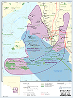
A number of National Parks and Wildlife reserves overlie the
However, exploration access is not restricted in the prospective areas.
Figure 5 shows the licence status at the time of publication. Further information on holders of petroleum tenements in South Australia.
Crawford, 1965. The Geology of Yorke Peninsula. Geol. Surv. S. Aust Bulletin 39.
Flöttmann T, Haines PW, Cockshell CD and Preiss WV, 1998. Reassessment of the seismic stratigraphy of the early Palaeozoic Stansbury Basin, Gulf St Vincent, South Australia. Australian Journal of Earth Sciences, 45:547-557.
Gravestock, D.I., 1995. Early and Middle Palaeozoic. In Drexel, J.F. and Preiss, W.V.(editors) Geology of South Australia. Volume 2. The Phanerozoic. Geological Survey of South Australia Bulletin 54, pp 3-61.
Gravestock DI, Alexander E, Demidenko YuE, Esakova NV, Holmer LE, Jago JB, Tian-rui Lin, Melnikova LM, Parkhaev PYu, Rozanov AYu, Ushatinskaya GT, Zang W, Zhegallo EA and Zhuravlev AYu, 2001. The Cambrian biostratigraphy of the Stansbury Basin, South Australia. Russian Academy of Sciences Palaeontological Institute. Transactions, 282.
Haines PW and Flöttmann T, 1998. Delamerian Orogeny and potential foreland sedimentation: a review of age and stratigraphic constraints. Australian Journal of Earth Sciences, 45:559-570.
Jago JB and Moore PS eds, 1990. The evolution of a Late Precambrian – early Palaeozoic rift complex: the Adelaide Geosyncline. Geological Society of Australia. Special Publication, 16.
Jago JB, Sun X and Zang W, 2002. Correlation within early Palaeozoic basins of eastern South Australia. South Australia. Department of Primary Industries and Resources. Report Book, 2002/00033.
Sprigg RC, 1961. Oil and gas possibilities of the St Vincent Gulf graben. APEA Journal, 1:71-88.
Stuart WJ and von Sanden AT, 1972. Palaeozoic history of the St Vincent Gulf region, South Australia. APEA Journal, 12:9-16.
Teasdale J, Pryer L, Etheridge M, Romine K, Stuart-Smith P, Cowan J, Loutit T, Vizy J and Henley P, 2001. Western Stansbury Basin SEEBASE Project. SRK Consulting report, SRK Project Code: PI12. South Australia. Department of Primary Industries and Resources. Open file Envelope, 9889 (unpublished).
Ward L.K., 1922. Prospects of the American Beach (KI) Oil Co. NL at the boresite, Section 134 Hundred Dudley. Geol. Surv. S. Aust Report Book 8/151.
Ward, L.K., 1932a. Inflammable gases occluded in the pre-palaeozoic rocks of South Australia. Geol. Surv. S. Aust Report Book 13/137.
Ward, L.K., 1932b. Government Geologist, 1932. The search for oil—notes by the Government Geologist. Geol. Surv. S. Aust, Mining Review 55, pp 39-42.
Ward, L.K., 1941. Report on search for petroleum in South Australia. Geol. Surv. S. Aust Report Book 18/135.