
On this page
The Warburton Basin is a Cambro-Ordovician basin.
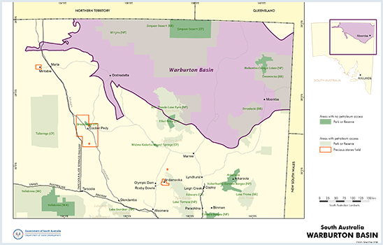
The Warburton Basin is a vast subsurface region north and north-east of the Gawler Craton which received sediments during the Cambrian and Ordovician.
2025 Daralingie Shelf Project
This new study has generated new datasets and new exploration concepts to help stimulate the next phase of gas exploration in the Warburton Basin (specifically the Daralingie Shelf region) to supply South Australian customers.
Learn about the Warburton Basin - Daralingie Shelf project
Publications
Kirk, R 2025. Seismic stratigraphy of the Cambrian Eastern Warburton Basin, South Australia. Report Book 2025/00020. Department for Energy and Mining, South Australia, Adelaide
Summary
| Age | Cambro-Ordovician |
|---|---|
| Area in South Australia | 45 000 km2 (17 370 sq miles) east of Birdsville Track Ridge |
| Depth to target zone | 1400-3600+m |
| Thickness | 1800+m |
| Hydrocarbon shows | 30 oil and 60 gas shows recorded beneath SW Cooper Basin |
| First commercial discovery | 1990 oil (Sturt 6), 1990 gas (Moolalla 1) |
| Identified reserves | Not available |
| Undiscovered resources (50%) | Not determined |
| Production | Not determined |
| Basin type | Polyphase foreland, rift/sag |
| Depositional setting | Carbonite/siliciclastic shelf, slope and basin above volcanics |
| Reservoirs | Fractured dolomite, volcanics, sandstone |
| Regional structure | Flat to steeply dipping: folds, thrust faults |
| Seals | Local informational seals; relies mainly on altered zone at boundary witih Cooper Basin |
| Source rocks | Currently no known indigenous source; gas and oil from downdip Cooper Basin source rocks |
| Number of wells | 420 |
| Seismic line km | 83122 2D; 13352 km2 (87943 km) |
Figures
Prospectivity
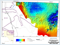
Seismic surveys led to the drilling of Innamincka 1 in 1959 and thus the discovery of Permian non-marine sediments as well as a thick succession of redbeds now known to be Early Ordovician in age (Innamincka Formation). Seven dry holes were drilled including Gidgealpa 1 which tested gas-cut salt water from Cambrian dolomite and recorded fluorescence at several levels. An updip test of the dolomite led to the discovery in 1963 of commercial Permian gas in Gidgealpa 2 (the dolomite was faulted out), thus subsequent exploration focused on the Permian Cooper Basin, rather than the deeper, complex early Palaeozoic section.
Despite extensive seismic surveys, Warburton Basin structural definition in key regions is hampered by high structural dip and masking effects of Permian coals. Exploration drilling through the 1970s and 1980s met with no commercial success. However, the discovery of commercial gas in Lycosa 1 and Moolalla 1, and oil in Sturt 6, all drilled in 1990, has led to renewed interest in the early Palaeozoic ‘economic basement’ — not for indigenous petroleum but for oil and gas trapped updip from Permian source rocks. Early in 2001, Challum 19 in South West Queensland flowed gas at 211 000 m3/d (7.5 mmcfd) from the Kalladeina Formation.
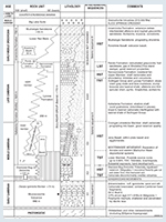
A stratigraphic summary of the eastern Warburton Basin is shown in Figure 3. The oldest rocks comprise Early Cambrian acid–intermediate volcanics, tuff and agglomerate of the Mooracoochie Volcanics (sequence 1) which correlate with the Truro Volcanics in the Stansbury Basin and Mt Wright Volcanics – Cymbric Vale Formation in western New South Wales.
Four seismic sequence sets above the Early Cambrian volcanics can be differentiated on regional reflection seismic records. Biostratigraphy has greatly assisted widely spaced well correlation. Sequence Є2 is characterised by dolomite with vuggy and moldic porosity (Diamond Bog Dolomite), indicating a highstand deposit altered by sub-aerial exposure. Sequence Є3 is characterised by a back-stepping style and several stacked cycles of catch-up and keep-up carbonate systems (lower Kalladeina Formation/Dullingari Group). Sequence Є4 was deposited after a major transgression following low relative sea level (Upper Kalladeina Formation/Dullingari Group). The succeeding highstand systems tract can be subdivided into three major parasequence sets: early highstand aggradation, middle highstand progradation and late highstand regression. A relative sea-level fall due to either tectonic uplift or a lack of accommodation space probably ended Sequence Є4.
The uppermost sequence (Innamincka Formation) is characterised by numerous stacked shoaling-upward parasequences, which may indicate a shallow stable shelf under influence of frequent sea-level fluctuations. An increase in siliciclastic content at the expense of carbonate suggests an approaching shoreline. Shoaling is recorded on the Coongie–Cuttapirrie shelf, and the Innamincka Formation continues this trend to shallow subtidal water depths as part of a deltaic complex with clastics probably derived from the Proterozoic Arunta Block to the north. The Pando Formation is an extensive marine shelf sand equivalent to the lower Innamincka Formation. Narcoonowie Formation is a laterally equivalent lowstand fan.
Black shale of the Dullingari Group with rare graptolites was deposited in deep water of the Tilparee Trough to the south during the Early Ordovician. This trough, bordered to the north by the Innamincka Shelf and to the south by the Gnalta Shelf, formed part of the Larapintine Sea which extended through the Warburton and Amadeus basins to the Canning Basin.
Rare conglomerate within the Dullingari Group may signify renewed tectonism, possibly associated with sea-level fall and exposure of the Innamincka Delta at the end of the Early Ordovician. Lithic sandstone in the Toolachee area contains volcanic detritus suggesting erosion of the Mooracoochie Volcanics and/or of younger basalt. Middle to Late Ordovician shale and siltstone constitute the last preserved record of the eastern Warburton Basin.
Source rock quality of samples principally from the Kalladeina Formation is poor to fair. With the exception of anomalously low maturity indices from Kalladeina 1, the succession below 3000 m is late-mature to post-mature for oil. Organic matter is mainly Type II kerogen derived from marine algal–bacterial precursors. Heat flow associated with the Alice Springs Orogeny is likely to have reduced any remaining hydrocarbon potential east of the Birdsville Track Ridge. However, the high present day geothermal gradients in the region (≤40 ºC/km) result from a Plio-Pleistocence (1–2 Ma) increase in heat flow of unknown origin.
A TEISA–SPIRT project on oil migration in the Cooper and Eromanga basins (McKirdy et al., 2005) has recognised pre-Permian inputs to oil pools on or adjacent to the Gidgealpa and Warra ridges, notably at Gidgealpa, Meranji, Muteroo, Malgoona and Sturt, but also at Cowan and Mudlalee. The most likely source rocks are Cambrian carbonates in the underlying Warburton Basin.
Fractures in brittle siltstones, such as those in the Dullingari Group in Lycosa 1, are capable of producing commercial oil and gas.
Pando Formation sandstone ranges in porosity from 5 to 20% but relies on fractures for permeability. The unit is glauconitic and zircon-rich and consequently has a high gamma ray response. Moolalla 1 gas is reservoired in this formation which extends from Pando wells in the west to Moomba wells in the NE.
Basal and middle Kalladeina Formation dolomites represent shelf limestones exposed to meteoric diagenesis during marine lowstands. Although minor gas shows have been recorded, porosity prediction has proved elusive, the dolomites and associated karst breccias proving tight when drilled.
Sturt 6 oil was produced from fractured and weathered tuff and ignimbrite which form the Mooracoochie Volcanics. Porosity values reach 17% due to dissolution of feldspar and glass shards, but fractures create the necessary permeability for flow.
Seals are general intraformational or the shale units in the overlying Permian Cooper basin, but recognition of a unique alteration profile at the base Cooper Basin unconformity — ‘basement’ (Warburton Basin) reservoirs sealed by an altered zone — has generated a new play concept and could have profound implications for drilling depths and costs. The nature of the alteration remains enigmatic and it is uncertain if it is a palaeosol or a result of hydrothermal alteration.
There is potential for structural traps updip from Permian source rocks.
There is no estimate of undiscovered resources.
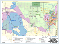
Exploration is permitted in both the Strzelecki and Innamincka Regional reserves which overlie the eastern Warburton Basin (South Australia Reserved Land figure).
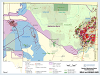
Figure 4 shows the licence status at the time of publication. Use this link for further information on holders of petroleum tenements in South Australia.
Boucher RK, 2001a. Warburton Basin GIS data atlas. South Australia. Department of Primary Industries and Resources. Report Book, 2001/00019.
Boucher RK, 2001b. The nature and origin of the altered zone at the base Cooper Basin unconformity. South Australia. Department of Primary Industries and Resources. Report Book, 2001/00012. Note: this report is included in Boucher (2001a) above.
Carr, L. K., Korsch R. J., Palu T. J. and Reese, B. 2016 Onshore Basin Inventory -The McArthur, South Nicholson, Georgina, Wiso, Amadeus, Warburton, Cooper and Galilee basins, central Australia. Geoscience Australia Record 2016/04
Jago JB, Sun X and Zang W, 2002. Correlation within early Palaeozoic basins of eastern South Australia. South Australia. Department of Primary Industries and Resources. Report Book, 2002/00033.
McKirdy DM, Arouri KR and Kramer L, 2005. Conditions and effects of hydrocarbon fluid flow in the subsurface of the Cooper and Eromanga basins. University of Adelaide report on ARC SPIRT Project C39943025 for PIRSA and Santos Ltd. South Australia. Department of Primary Industries and Resources. Report Book, 2005/00002.
Roberts DC, Carroll PG and Sayers J, 1990. The Kalladeina Formation — a Warburton Basin Cambrian carbonate play. APEA Journal, 30:166-183.
Sun X, 1998. Prediction of carbonate reservoirs and traps by applying sequence stratigraphy in the eastern Warburton Basin, South Australia. APPEA Journal, 38:380-398.
Sun X, 1999. Fracture analysis of the eastern Warburton Basin (early Palaeozoic), South Australia. South Australia. Department of Primary Industries and Resources. Report Book, 99/00014.
Sun X and Gravestock DI, 2001. Potential hydrocarbon reservoirs in upper levels of the eastern Warburton Basin, South Australia, South Australia. Department of Primary Industries and Resources. Report Book, 2001/00016. Note: this report is included in Boucher (2001a) above.
Sun X and Nicoll RS, 2004. Cambro-Ordovician conodont biostratigraphy and thermal maturation of the eastern Warburton Basin, South Australia. In: Boult PJ, Johns DR and Lang SC eds, PESA’s Eastern Australasian Basin Symposium II, Adelaide 2004.
Petroleum Exploration Society of Australia. Special Publication, pp. 725-734.
Taylor S, Solomon G, Tupper N, Evanochko J, Horton G, Waldeck R and Phillips S, 1991. Flank plays and faulted basement: new directions for the Cooper Basin. APEA Journal, 31:56-73.
Geology
The Warburton Basin is a vast subsurface region north and NE of the Gawler Craton which received sediments during the Cambrian and Ordovician. It is less certain that Devonian strata were extensive; these have been confirmed only beneath the Pedirka Basin, and are inferred from seismic data in the Boorthanna Trough. Late Carboniferous and younger strata completely cover the Warburton Basin.
The eastern Warburton Basin is essentially a fold belt deformed and uplifted during the Carboniferous Alice Springs Orogeny (or the equivalent Kanimblan Orogeny) and subsequently buried beneath the Cooper Basin. Structural dip varies from sub-horizontal beneath the Patchawarra Trough and GMI Ridge to vertical and locally overturned. Such variation is often evident beneath a single Permian structure (e.g. Moomba, Daralingie). Early to Middle Carboniferous Big Lake Suite granitic intrusives beneath the Nappamerri Trough were responsible for local contact metamorphism of Cambrian country rock.
A weathered zone up to 150 m thick has altered Warburton Basin strata and the granites in particular, immediately beneath the Cooper Basin unconformity. Within the early Palaeozoic, disconformities at three stratigraphic levels are related to tectonic events. Other breaks, especially on the carbonate shelf, are sequence boundaries marked by relative sea-level fall and karst development. A major delta formed during the Early Ordovician on the northern margin of a deep marine trough and prograded southward.
Early to Late Cambrian intraplate rifting is interpreted to have propagated NNW, possibly connected with the Koonenberry Fault Zone which originated in western New South Wales. Structural style superimposed by deformation during the Alice Springs Orogeny follows arcuate NE trends imposed by NW-directed thrust faults. Cambrian strata repeated by thrusting are evident at Gidgealpa and Daer to the north. Wrench fault zones have been mapped seismically in the Titan–Charo–Yanta area on the NW flank of the Patchawarra Trough. Complex folding and faulting, not yet properly delineated, are evident in the Mulga–Baratta and Toolachee–Kidman areas. These appear to consist of linear and en echelon, short meridionl fault blocks beneath Permian anticlines.
See Warburton Basin figures 1 and 2