
On this page
The Officer Basin is a Neoproterozoic (Adelaidean) - middle Palaeozoic (Devonian) basin.
Officer Basin represents one of the last remaining onshore frontier exploration areas where large petroleum discoveries may still be made.
For information on Officer Basin structural and tectonic history, new seismic mapping, litho- and biostratigraphy, source rocks and maturity, reservoirs, seals, trap development, discovered reserves, field reviews, undiscovered potential, exploration history, infrastructure, economics and land access considerations see the Petroleum geology of South Australia. Volume 3: Officer Basin.
Summary
| Age | Neoproterozoic (Adelaidean) - middle Palaeozoic (Devonian) |
|---|---|
| Area in South Australia | 176 000 km2 (67 935 sq miles) |
| Exploration Well Density | 1 well per 8,800 km2 (1 well per 3396 sq. miles) |
| Success ratio | No discoveries |
| Depth to target zone | 200-2000m |
| Thickness | Up to 10 000m |
| Hydrocarbon shows | Found in 4 formations, the majority in a lay carbonate in the Marla Overthrust Zone. |
| First commercial discovery | None |
| Identified reserves | Nil |
| Undiscovered resources (50%) | 400x106 kL (2516 mmbl) recoverable oil (DEM estimate 1997, Monte Carlo method) |
| Production | Nil |
| Basin type | Intracratonic |
| Depositional setting | Marine shelf - epeiric sea, sabkha - alkaline playa |
| Reservoirs | Sandstone, carbonate |
| Regional structure | Foreland basin, thrust complexes (Adelaidean, Late Cambrian, Devonian); salt walls, salt pillows. |
| Seals | Shale, Siltstone, evaporites |
| Source rocks | Siltstone, carbonate |
| Number of wells | 20 petroleum exploration, 32 Stratigraphic/deep mineral (>400m) |
| Seismic line km | 13528 2D onshore, 509 2D offshore |
Figures

Prospectivity
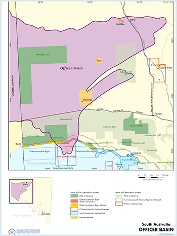
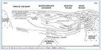
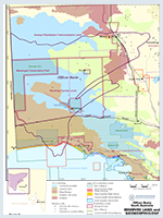
The Officer Basin spans 525 000 km2 of central southern Australia from the Yilgarn Block in Western Australia east to the Gawler Craton in South Australia. It is an arcuate depression 500 km long with six main depocentres containing flat to gently dipping Neoproterozoic and Palaeozoic sediments. About one third of the total area, 176 000 km2, comprises the Officer Basin in South Australia. Officer Basin sediments crop out in a linear belt south of the Musgrave Block, marking the northern limit of the basin. Outcrop is sporadic elsewhere. To the south the basin is overlapped by up to 400 m of Cainozoic, Mesozoic and locally, Permian strata. The eastern margin is ill defined.
The two major depocentres in South Australia, the Birksgate Sub-basin and Munyarai Trough, are separated by a structural rise, and contain 5–10 km of sediment respectively. Subsidence began in the Neoproterozoic (~820 Ma). A single drillhole in each depocentre indicates similar Neoproterozoic sections. A thin Devonian section overlies the Ordovician in the Munyarai Trough, but much of this has been removed elsewhere by Carboniferous erosion following the Alice Springs Orogeny.
Early Adelaidean units outcrop only in the north of the basin. Late Adelaidean sediments are thickest in the north but extend south, becoming thinner and shallower on the Murnaroo and Nullarbor Platforms, which continue southwards to the Great Australian Bight.
Northeast-trending thrust faults separate the Munyarai Trough from the Manya and Tallaringa troughs which contain mainly Early Cambrian sediments. Thin, mainly Neoproterozoic strata extend across the Murnaroo Platform.
During the early Neoproterozoic, the Officer was a component of the giant Centralian Superbasin. The two main episodes of structuring occurred during the Late Devonian to Early Carboniferous (Alice Springs Orogeny) and the terminal Proterozoic (Petermann Ranges Orogeny). Uplift and erosion also affected the NE part of the basin during the Late Cambrian Delamerian Orogeny.
The Officer Basin represents one of the last remaining onshore frontier exploration areas where large petroleum discoveries may still be made. It has close geological affinities with the productive Amadeus Basin in the Northern Territory, and with basins in the former USSR and Oman, both of which host giant oil and gas fields and have proven oil reserves in the order of billions of barrels.
Numerous oil shows are known in the Officer Basin from mineral and stratigraphic drillholes, although there has been little on-structure drilling for petroleum targets. Excellent reservoir quality and source are proven. Evaporites and salt tectonics are evident and may provide viable trapping and preservation mechanisms.
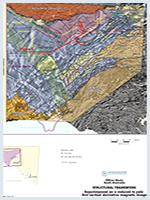
Petroleum exploration began in the 1960s, initially by Exoil, Conoco and Outback Oil. Seismic, aeromagnetic and gravity surveys were carried out and seven stratigraphic and two exploration wells drilled. Minor hydrocarbon shows were encountered in Denman 1 on the southern Murnaroo Platform. Sporadic exploration was continued by the Mines and Energy department until 1979 when the Byilkaoora 1 stratigraphic well intersected significant oil bleeds in the Observatory Hill Formation. Stimulated by this discovery, Comalco carried out extensive mineral and petroleum exploration from 1980–89, including over 2500 km of seismic (mainly weight-drop, Fig. 1), five exploration wells and 20 deep mineral holes. Drillholes were extensively cored and most had wireline logs, though of poor quality.
Comalco exploration significantly improved understanding of the geology and petroleum potential of the NE Officer Basin. Amoco briefly explored an adjacent area in the mid 1980s, acquiring 235 km of 2D Vibroseis data and tying Munyarai 1 to Ungoolya 1. In 1993 AGSO recorded a 550 km transect (explosive source) across the Murnaroo Platform and Birksgate Sub-basin. In the same year, the Mines and Energy department recorded 378 km of Vibroseis in the Marla area.
Hemley Exploration, operator of PELs 61 and 63 in the Marla Overthrust Zone, carried out a detailed aeromagnetic investigation in 1998. This new aeromagnetic data was meshed in with previous aeromagnetic and seismic data and interpreted by Leigh Rankin.
Canadian explorer Rodinia Oil Corp, through an affiliate, Officer Basin Energy Pty Ltd, was granted two PELs in the Officer Basin in July 2007 after successfully concluding a conjunctive access agreement with the traditional Aboriginal owners of Maralinga Tjarutja Lands (Officer Basin Energy became Rodinia Oil Corp. in 2008). The company recorded 985 line-km of seismic in late 2007 and early 2008 (Phase I seismic program), then followed up with 526 line-km of exploration seismic in early 2009 (Phase II). Between November 2010 and June 2011 Rodinia acquired an additional 41 lines of seismic data totalling 2536 line km in PELs 81 and 253.
In June 2011 Rodinia spudded its first oil exploration well in PEL 253 (near the SA-WA border) and drilled to a depth of ~2700m intersecting five prospective formations. Rodinia has stated that the well, Mulyawara 1, confirmed the presence of excellent reservoir quality rocks in the Neoproterozoic succession and provided evidence of a petroleum system. A second well, Kutjara 1, was also drilled in Q4 2011. Rodinia Oil Corp. currently holds two PELs (PELs 81 and 253) and three PELAs (303, 351 and 445) in the Officer Basin. Rodinia Oil is now in liquidation and the licence assets may be sold in the near future.
PELA 139 (now PELs 499 and 500) was granted in April 2007 to Dawnpark Holdings Pty Ltd and Standard Oil Pty Ltd. The companies were then operators of seven PELAs in the Officer Basin, and planned to negotiate access with the traditional Aboriginal owners of Anangu Pitjantjatjara Yankunytjatjara and Maralinga Tjarutja lands in 2007–08. Ahava Energy Pty Ltd (Ahava) farmed in to the Standard–Dawnpark licences in 2008 and commenced exploration in the Officer Basin with a 1300 line-km seismic program in early 2009. Ahava acquired an additional 362 line-km of seismic data in late 2009 and drilled three petroleum exploration wells (Welbourn Alpha 1 – PEL 499, Trainor Echo 1 – PEL 138 and Trainor Alpha 1 – PEL 138) in 2010. In 2011 Ahava acquired a small seismic survey comprising 7 lines for a total 85 line km in PEL 499 and in 2012 drilled a petroleum exploration well (Adi 1) near the southern boundary of PEL 143.
PELAs 147 and 148 were granted to Ahava in July 2011. Ahava (and subsidiary companies) now holds six PELs (138, 143, 147, 148, 499, 500) and 13 PELAs in the Officer Basin. Ahava are now actively seeking farm-in partners to progress exploration of these permits.
Stratigraphy of the eastern Officer Basin and a rock-relation diagram linking the Birksgate Sub-basin, Munyarai Trough and Murnaroo Platform Details of each unit are available in reports cited below. The sediment packages of immediate interest are the Neoproterozoic (Willouran, Marinoan) and Cambro-Ordovician.
Willouran
The oldest rocks in the cover sequence, the ~800 million year old Pindyin Sandstone and Alinya Formation were deposited in the (present day) southern reaches of a saline supergiant basin that might have been up to 2 000 000 km2 in area. The section ranges from 200 m to at least 600 m thick. Outcrops are sparse; but the formations are widespread on seismic evidence. Giles 1 and Watson Siding 1 were the only well intersections until Rodinia Oil Corp drilled the Mulyawara 1 and Kutjara 1 wells in 2011.
Correlated units in Western Australia are the Townsend Quartzite, Browne and Lefroy beds; in the Amadeus Basin, Northern Territory, the Heavitree Quartzite and Bitter Springs Formation are equivalents. Salt in the Alinya sabkha facies formed a major decollement for the propagation of thrust faults; salt structures (swells, pillows and salt walls) occur on the NW margin of the Murnaroo Platform. The aeolian–fluvial Pindyin Sandstone has excellent reservoir potential and the sabkha facies of the Alinya Formation contains gas-prone source rocks and seal potential.
Sturtian
The presence of sediments equivalent to the Burra Group (Willouran to Sturtian age) of the Adelaide Geosyncline, interpreted on seismic lines acquired by Rodinia Oil Corp in the western Officer Basin, was confirmed by the 2011 Mulyawara 1 and Kutjara 1 wells. Uplift and erosion during the Areyonga Movement (780-760 Ma) resulted in removal of most of the Burra Group equivalent sediments in the eastern Officer Basin. Effects of the Areyonga Movement decrease westwards across the basin.
Marinoan
The Marinoan sedimentary succession from the Tarlina to the Punkerri Sandstone records the transition from fluviodeltaic to fully marine conditions in the Officer Basin between ~650 and 540 million years ago. The sediments are widespread with most units being at least partially intersected by wells on the Murnaroo Platform. Munyarai 1 and Birksgate 1, the only deep wells in the major depocentres where 5 km or more were deposited, have partly intersected these sequences. Formations of the Ungoolya Group are dominated by muddy dolomitic siltstone with minor limestone in the Munyarai Trough, whereas sandy sediment and limestone characterise the Birksgate Sub-basin.
A major canyon cutting event reflects early uplift on the Ammaroodinna Ridge. These movements, which also affected the Adelaide Geosyncline to the east, were precursors of the transpressional Petermann Ranges Orogeny. A shift in depocentres from the Munyarai Trough to the Birksgate Sub-basin resulted from this uplift.
Cambrian
The Manya and Tallaringa troughs subsided after the Petermann Ranges Orogeny. Early Cambrian aeolian, fluvial, salina and epeiric sea deposits of the Relief Sandstone and Ouldburra Formation accumulated in these troughs and the adjacent hinterland. These sediments exceed 1100 m thickness in Manya 6 and have been intersected primarily in mineral drillholes in the Marla Overthrust Zone in the eastern part of the basin. Wilkinson 1 in the Tallaringa Trough reached total depth in the Relief Sandstone after intersecting more than 500 m of these sediments, including oil-prone source rocks in the Ouldburra Formation.
Similar, though thinner sections with ‘petroliferous shale’ were drilled in Karari 1 and 2A, 65 km SW of Wilkinson 1. The overlying Observatory Hill Formation rose to prominence in 1979 with the discovery in Byilkaoora 1 stratigraphic well of oil generated in situ in alkaline playa lake carbonate. This formation hosts the richest source rocks known in the Officer Basin. Fluvial, paralic and marine conditions are recorded in the overlying formations which principally comprise arkosic sandstone and interbedded mudrock. Potential reservoirs have been identified (see below).
Ordovician and Devonian
Ordovician and Devonian rocks locally exceed 1 km in thickness and were once probably up to 3 km thick. The Ordovician is sandstone dominated while the Devonian, intersected only in Munyarai 1, is characterised by freshwater lacustrine deposits (with fossil fish fragments) and evaporative redbeds. These rocks are important indicators of a northward thickening sediment wedge which buried Cambrian strata to petroleum generative depths. The Ordovician and Devonian are structurally concordant with the underlying rocks and were deformed with them by the advancing thrust sheets that signalled the Alice Springs Orogeny. Excellent potential reservoirs exist in the Ordovician Mt Chandler Sandstone, but unless structurally sealed beneath hanging wall rocks, they are at risk from Permian erosion.
Oil shows (in the form of fluorescence, bleeds, stains and extracts) occur in six different formations and belong to four genetically distinct oil families, implying the existence of multiple effective source rocks.
TOC values in the Alinya Formation from Giles 1 (six samples from 1238 to 1266 m) only reach 0.62% (mean 0.36%) in the 35 m thick sabkha facies. Organic richness is poor to fair, kerogen is gas-prone and maturation levels correspond to the oil generation window. Molecular biomarkers indicate eukaryotic algal and bacterial sources. The same molecular fossil assemblage is found in oil extracted from the much younger Murnaroo Formation and Relief Sandstone. MPI measurements suggest these oils are relatively late expulsion products.
The Dey-Dey Mudstone and Narana Formation have TOC values to 1.47% (87 samples, mean 0.28%). The highest values are from transgressive and late highstand systems tracts but sampling has been random as shown by the low mean value. A marine source is inferred from sterane distributions similar to those reported in oils from Oman and Siberia.
Shallow marine carbonates of the Ouldburra Formation have variable TOC values from 0.04 to 1.87%. The richest potential source beds are thin (~1 m) but widespread and appear to be concentrated in sabkha and highstand sediments. Kerogen is of poor quality and mature to overmature in the NE part of the basin, but good quality Type II kerogen in the main oil generative window (VRcalc = 0.58–0.8%) occurs in Wilkinson 1 and Karari 2A in the Tallaringa Trough. The oil source is of algal origin. One sample from Manya 6 appears to be stained by migrated hydrocarbons.
A quite distinct oil family occurs in the non-marine, alkaline playa lake sediments of the Observatory Hill Formation. There are nine recorded occurrences of oil bleeds and oil stains in vugs and fractures from depths as shallow as 200 m below surface. TOC values range from 0.5 to 1.4%, calculated vitrinite reflectance (VRcalc) places the Byilkaoora 1 intersection in the oil window (VRcalc = 0.9–1.0). The playa lake facies (Parakeelya Alkali Member) extends for 200 km along the Manya Trough, reaching the surface at Observatory Hill. (See figure 3)
The Munyarai and Manya Troughs and the Marla Overthrust Zone are prospective for conventional oil and gas and unconventional tight gas.
Burial history modelling (Gravestock and Hill, 1997) of the Manya Trough (based on Manya 6 well) suggests the entire sequence below ~175m lies in the gas window with wet gas down to ~944 m. Significantly, source rocks of the Ouldburra Fm have remained in the wet gas window just after the Alice Springs Orogeny (~360 Ma) and have remained in the wet gas window to present day. It is expected that structures that were in place as a result of the Petermann and Delamerian Orogenies could be charged.
The Officer Basin contains a number of reservoirs with excellent porosity and permeability. These are generally sandstones of fluvial or aeolian origin, and were originally feldspathic, but dissolution of the feldspars has led to extensive secondary porosity development, in some cases with permeabilities over 8 darcys (8000 mD). Reservoir potential also exists in carbonates (vuggy porosity). Most of these reservoirs have semi-regional seals.
Sandstone reservoirs are primary exploration targets due to their thickness and wide extent. Intra-Ouldburra dolomite and Observatory Hill Formation chert are potential reservoirs and were intersected when Comalco’s exploration concentrated on evaporites in the Marla area. In the Munta area Comalco’s search for petroleum was centred chiefly on the Ungoolya Group siltstone which, it was hoped, had significant fracture porosity. This did not eventuate. Only two Comalco wells (Giles 1, Ungoolya 1) targeted anticlinal closures. Current interpretation suggests these wells were drilled off-structure. Conoco well Munyarai 1 drilled a large anticline but failed to reach sealed Neoproterozoic reservoir sand. Summaries of the reservoir characteristics of each formation are given below.
The clean, aeolian Pindyin Sandstone at the base of the section in Giles 1 (porosity 3.8–22.5%, mean 11.8%; permeability 0.04–1538 mD, mean 48 mD) is widespread, outcropping on the northern margin of the Birksgate Sub-basin, and occurring at shallow depth on the southern Murnaroo Platform (~450 m in Watson Siding 1a).
The alluvial–tidal – shallow marine Tarlina Sandstone disconformably overlies the Alinya Formation on the Murnaroo Platform (porosity 9.0–19.6%, mean 15.9%; permeability 0.16–4.5 mD, mean 1.2 mD). It is arkosic with a calculated shale volume of 5–25%.
The Murnaroo Formation was deposited in a lower alluvial plain to shoreface setting on the Murnaroo Platform and east of the Manya Trough (porosity 1.2–18.8%, mean 14%; permeability 0.01–213 mD, mean 20 mD). It is feldspathic, micaceous and locally glauconitic.
The Early Cambrian Relief Sandstone disconformably overlies the Proterozoic in the Manya Trough. Aeolian, fluvial and tidal facies are related to cycles of relative sea-level change. Porosity is variable and related to burial depths reached during the Alice Springs Orogeny. Footwall situations average 2.9%, hanging wall situations 6.7%. On the Murnaroo Platform porosity values average 16.4%, with permeability up to 8000 mD resulting from dissolution of clay and carbonate cements.
Relief-type sandstones are interbedded with Ouldburra lowstand deposits (porosity 1–23%, permeability
0–596 mD). Intercrystalline porosity and permeability of Ouldburra dolomites are greater (6–23%, 23–1640 mD) thus this unit has both source and reservoir potential.
The Cambrian Arcoeillinna and Trainor Hill sandstones extend through the Manya and Munyarai troughs and onto the Murnaroo Platform. The Arcoeillinna is an immature, muddy micaceous arkose with poor to excellent reservoir properties. Average porosity is high (13%) and permeability ranges from 0.1 to 1700 mD.
The Trainor Hill Sandstone is fine grained, usually quartzose, with average porosity of 15% and permeability in the tens to hundred millidarcy range. Thickness of this sandstone is variable owing to Delamerian erosion.
The Ordovician Mt Chandler Sandstone (porosity 12.7–19.7%, permeability 0.26–238 mD) is a clean quartzose sandstone. Reservoir potential is good but due to its stratigraphic position the Mt Chandler risks lack of seal resulting from Permian erosion. However, it presents an excellent footwall target in overthrust zones.
Evaporites, which may act as very good seals, have been recorded at many horizons below the Middle Cambrian including the Observatory Hill Formation, Ouldburra Formation, Mena Mudstone Member, Tanana Formation, Dey Dey Mudstone, Meramangye Formation, Coominaree Dolomite and the Alinya Formation. Evaporites of the Alinya Formation have been deformed diapirically across much of the NE of the basin. However, to the SW of the Birksgate – Coober Pedy Corridor there is evidence of stable evaporites overlying sediments of high reflectivity.
Conventional
Although no commercial discoveries have been made in the Officer Basin, hydrocarbon shows have been found in 4 formations (the majority in a playa carbonate in the Marla Overthrust Zone) including significant oil bleeds in the Observatory Hill Formation in Byilkaoora 1 stratigraphic well.
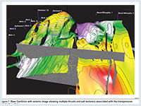
Traps range from simple domes and faulted anticlines to salt swells, pillows and salt walls and drape over basement horst blocks (movie: 3D model of the Manya and Wintinna Trough areas. Stratigraphic traps are expected in the carbonates. Neoproterozoic thrust zones were reactivated in the Late Devonian and provide trap opportunities close to the Musgrave Block and on the northern margin of the Manya Trough. The largest fault complex strikes NE–SW almost 140 km, with vertical displacements up to 2 km. Hanging wall anticlines are the principal targets. (See figure 7)
Unconventional
Tight Gas Play
Burial history modelling of the Marla Overthrust Zone (Gravestock and Hill, 1997), based on Byilkaoora 1, suggests that the Dey Dey Mudstone – Karlaya Limestone source rock package entered the wet gas window at ~550 Ma during the Delamerian Orogeny and passed into the dry gas window between ~490 and 475 Ma. In this region, thick sandstone sequences of the Tarlina Sandstone and Murnaroo Formation and interbedded sandstone, siltstone and conglomerates of the Narana Formation represent viable tight gas targets.
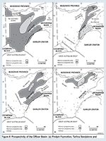
An assessment of the undiscovered petroleum potential of the Officer Basin in South Australia is summarised in Table 1 and Figure 8.
The average estimate of the potential plays is ~400 x 106 kL (~2516 mmbbl) of recoverable oil. These estimates may appear to be large in comparison to other, geologically younger, Australian petroleum basins, but are comparable to Proterozoic–Cambrian analogues elsewhere in the world. The Lena–Tunguska province in the Siberian Platform has a predicted potential of 318 x 106 kL (2000 mmbbl) of oil and gas liquids and 2417 x 106 m3 (85.8 bcf) of gas; the Moscow Basin has a potential of 2353 x 106 kL (14 800 mmbbl) of gas liquids. Proterozoic sediments are a very significant source for the prolific oil and gas fields of the Persian Gulf area; the proven oil reserves in Oman alone are 795 x 106 kL (5000 mmbbl).
Table 1- Undiscovered recoverable oil resources of the Officer Basin (South Australia)
| UNDISCOVERED POTENTIAL 106 kL (mmbbl) | ||||||
| PLAY | Probability that the ultimate potential will exceed the stated value: | |||||
| 90% | 50% | 10% | ||||
| Arcoeillinna Sandstone | 3.3 | (21) | 10.8 | (68) | 27.8 | (175) |
| Ouldburra Formation | 29.4 | (185) | 85.1 | (535) | 209.9 | (1320) |
| Relief Sandstone | 6.3 | (40) | 30.3 | (191) | 95.0 | (598) |
| Murnaroo Formation | 21.7 | (137) | 69.1 | (435) | 210.4 | (1323) |
| Tarlina Sandstone | 18.6 | (117) | 63.7 | (401) | 186.1 | (1171) |
| Pindyin Sandstone | 18.0 | (113) | 62.6 | (394) | 172.9 | (1088) |
A number of National Parks and Wildlife reserves are fully or partly located within the boundaries of the Officer Basin. Exploration is permitted in all except the Mamungari Conservation Park and Nullarbor Wilderness Protection Area.
The Officer Basin underlies Maralinga Tjarutja and Anangu Pitjantjatjara Yankunytjatjara (APY) lands and Yalata Aboriginal Reserve. Access to these areas is discussed under Aboriginal issues. Traditional Aboriginal owners of both APY and Maralinga Tjarutja lands have expressed willingness to allow further petroleum exploration on their lands.
Entry to the Woomera Prohibited Area, main roads excepted, must be cleared with the Director, Woomera Test Facility, located at the RAAF Base in Edinburgh, South Australia. Operators proposing to conduct activities within the prohibited area are required to liaise with the Director, Woomera Test Facility, and the Defence Legal Service to determine appropriate levels of insurance and indemnities to the Commonwealth. Some areas of the Woomera Prohibited Area (WPA) may be subject to access restrictions. Further important information regarding access to the WPA is available.
A petroleum exploration or production licence could be acquired over the Mintabie Precious Stones Field. However, the number of open cut mines could make access for petroleum exploration hazardous.
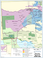
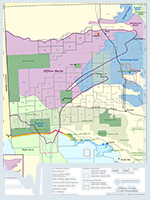
Licence activity in the previous year is discussed in the annual exploration and production review, and Figure 10 shows the licence status at the time of publication. For further information on holders of petroleum tenements in South Australia see the Quarterly Information Brochure (P1).
Amoco Australia Petroleum Co., 1987. PEL 29, Officer Basin. Reports for the period 1/11/85 to 31/10/87. South Australia. Department of Primary Industries and Resources. Open file Envelope, 6843 (unpublished).
Bailey, A., Wang, L., Dewhurst, D., Anderson, J., Carr, L.K, Henson, P. 2022 Geomechanical rock properties of the Officer Basin. The APPEA Journal 62 S385-S391.
Boult PJ and Rankin L, 2004. Eastern Officer Basin — new play — sleeping giant? In: Boult, PJ, Johns DR and Lang SC eds, PESA’s Eastern Australasian Basin Symposium II, Adelaide 2004. Petroleum Exploration Society of Australia. Special Publication, pp. 231-242.
Bradshaw BE, Khider K, MacFarlane S, Carr L, Henson P (2021) Tectonostratigraphic evolution of the Centralian Superbasin (Australia) revealed through three-dimensional well correlations. Record 2021/01. Geoscience Australia, Canberra.
Brewer AM, Dunster JN, Gatehouse CG, Henry RL and Weste G, 1987. A revision of the stratigraphy of the eastern Officer Basin. South Australia. Geological Survey. Quarterly Geological Notes, 102.
Cunneen, J.P., Crowe, W. and Peters, G. 2014 Cenozoic salt tectonics in the Officer Basin, Western Australia: implications for hydrocarbon exploration APPEA Journal, 54:167-180.
Edwards, D., Munday, S., Wang, L., Riley, D. and Khider, K. 2022. Neoproterozoic and Cambrian chemostratigraphic mega-sequences of the Officer Basin; a regional framework to assist petroleum and mineral exploration. Geoscience Australia Exploring for the Future Extended Abstracts.
Gravestock DI and Hibburt JE, 1991. Sequence stratigraphy of the eastern Officer and Arrowie basins: a framework for Cambrian oil search. APEA Journal, 31:177-190.
Gravestock, D.I., 1995. Early and Middle Palaeozoic. In Drexel, J.F. and Preiss, W.V.(editors) Geology of South Australia. Volume 2. The Phanerozoic. Geological Survey of South Australia Bulletin 54, pp 3-61.
Grey K, 1998. Ediacarian acritarch biozonation in Australia. In: Inaugural Sprigg Symposium, Adelaide, 1998. Geological Society of Australia. Abstracts, 51:22-23.
Hoskins D and Lemon NM, 1995. Tectonic development of the eastern Officer Basin, central Australia. Exploration Geophysics, 26:395-402.
Kamali MR, 1995. Sedimentology and petroleum geochemistry of the Ouldburra Formation, eastern Officer Basin, Australia. University of Adelaide. National Centre for Petroleum Geology and Geophysics. PhD thesis. South Australia. Department of Primary Industries and Resources. Open file Envelope, 8591 (unpublished).
Kamali MR, Apak SN and Lemon NM, 1995. Porosity generation and reservoir potential of the Ouldburra Formation in the Officer Basin, South Australia. APEA Journal, 35:106-120.
Lindsay JF ed, 1995. Geological atlas of the Officer Basin, South Australia. Australian Geological Survey Organisation and Department of Mines and Energy, South Australia.
Madden, R.H.C. and Tilbury, R.D. 2022. Exploring for the Future: petrology of the Officer Basin. Record 2022/35. Geoscience Australia, Canberra.
McKirdy DM, 1993. Oil shows and source rocks of the eastern Officer Basin — a review. In: Alexander EM and Gravestock DI eds, Central Australian Basins Workshop, Alice Springs, 13–14 September 1993. Program and Abstracts, pp. 68-70.
Michaelsen BH, Kamali MR and McKirdy DM, 1995. Unexpected molecular fossils from Early Cambrian carbonates. Proceedings of the 1995 Organic Geochemistry Conference. The University of Adelaide, p. 46.
Morton JGG and Drexel JF eds, 1997. The petroleum geology of South Australia. Vol. 3: Officer Basin. South Australia. Department of Primary Industries and Resources. Petroleum Geology of South Australia Series, Vol. 3.
Payenberg T.H.D., Lang, S., Deller, K., Ceglar, N. Reilly, M.R.W., Cotton, T and Krapf, C.B.E, 2005. Reducing critical uncertainties for deepwater stratigraphic architecture in the Officer Basin – the significance of outcrop analogues in the Flinders Ranges. University of Adelaide. Australian School of Petroleum. Reservoir Analogues Research Group. Unpublished Report, ASP-RARG-2005-01.
Priess, W.V., 1993. Neoproterozoic. In Drexel, J.F., Preiss, W.V. and Parker, (editors). Geology of South Australia. Volume 1. The Precambrian Geological Survey of South Australia Bulletin 54, pp 171-203.
Rankin, L., 2003. Eastern Officer Basin: Structural framework from geophysical data. South Australia. Department of Primary Industries and Resources. Report Book, 2003/00032.
Sukanta, U., Thomas, B., von der Borch, C.C. and Gatehouse, C.G., 1991. Sequence stratigraphic studies and canyon formation, South Australia. PESA Journal, 19:68-73.
Thomas B, 1990. Summary of seismic interpretation in the eastern Officer Basin. South Australia. Department of Mines and Energy. Report Book, 90/00058.
Tingate PR and McKirdy DM, 2003. Exploration opportunities in the Officer Basin, South Australia. Revised edn. South Australia. Department of Primary Industries and Resources. Report Book, 2003/00001.
Wang L., et al., 2022. Petrophysical characterisation of the Neoproterozoic and Cambrian successions in the Officer Basin. The APPEA Journal 62:381–399.
Zang W, 1995. Early Neoproterozoic sequence stratigraphy and acritarch biostratigraphy, eastern Officer Basin, South Australia. Precambrian Research, 74:119-175.
Zang W and McKirdy DM, 1994. Microfossils and molecular fossils from the Neoproterozoic Alinya Formation — a possible new source rock in the eastern Officer Basin. PESA Journal, 22:89-90.