
On this page
 The Bight Basin is a Late Jurassic to Late Cretaceous basin. The information presented here focuses on the Ceduna Sub-basin.
The basin comprises fluvial to paralic sediments of Late Jurassic to Early Cretaceous age, disconformably overlain by nearshore marine to non-marine Late Cretaceous sediments.
Important Note on the Regulatory Regime for Offshore Waters
Prior to 2012, each State and Territory was responsible for petroleum licensing and regulation in their respective offshore waters. However, following the amendment of the Offshore Petroleum and Greenhouse Gas Storage Act 2006 to implement recommendations from the Productivity Commission, responsibility for the licensing and regulation of petroleum-related activities occurring greater than 3 nautical miles from shore (or, technically, from the territorial sea baseline) passed from the various States and Territories to the Commonwealth Government. The National Offshore Petroleum Titles Administrator (NOPTA) was created to have responsibility for the day-to-day administration of petroleum & greenhouse gas titles in Commonwealth waters, with Geoscience Australia managing the well and seismic database (NOPIMS) for these areas on their behalf.
Summary
| Age | Late Jurassic - Late Cretaceous. |
|---|---|
| Area in South Australia | 325 000 km2 (125 000 sq miles) |
| Exploration Well Density | 1 well per 36, 111 km2 (1 well per 13,888 sq. miles) |
| Success ratio | no discoveries |
| Depth to target zone | 1000-3000m (Duntroon Sub-basin); 2000-6000m (Ceduna Sub-basin) |
| Thickness | 15km. |
| Hydrocarbon shows | Oil shows Greenly 1 (1993) |
| First commercial discovery | None. |
| Identified reserves | Nil. |
| Undiscovered resources (50%) | Not determined. |
| Production | Nil. |
| Basin type | Rift - passive margin. |
| Depositional setting | Non-marine to paralic (Early Cretaceous), marine to fluyiodeltaic (Late Cretaceous) |
| Reservoirs | Non-marine to marine sandstone. |
| Regional structure | Anticlinical closure against tilted fault blocks, flower structures. |
| Seals | Non-marine and marine shale and mudstone. |
| Source rocks | Non-marine to marine shale, coaly interbeds. |
| Number of wells | 9 offshore, 1 offshore, numerous stratigraphic. |
| Seismic line km | 92297 2D offshore, 670 2D onshore. 14536 sq km 3D offshore (22412 line km) |
Prospectivity
The Bight Basin spans an area of over 800 000 km2, straddling the border of Western Australia and South Australia extending onshore and offshore in water depths up to 5000+ m. It represents one of the largest offshore frontier basins in the world.
The ?Late Jurassic to Late Cretaceous Bight Basin is located in the central portion of the Australian Southern Rift System. The basin was formed as a result of extension and subsidence following the rifting between the Antarctic and Australian plates.
The stratigraphy and tectonic evolution, as well as the extent and boundaries of the Bight Basin have been revised based on recent work by Geoscience Australia. Currently, the South Australian sector of the Bight Basin comprises four main depocentres (Eyre, Duntroon, Ceduna and Recherche sub-basins) and two platform cover areas (Madura and Couedic Shelves. As a result, the region covered previously by the Duntroon Basin is now included in the Duntroon Sub-basin (equivalent to the former inner zone) and the eastern Ceduna Sub-basin (equivalent to the former outer zone).
The northern limit of the Bight Basin is taken as the most northern extent of Mesozoic sediment on the platform originally assigned to the Eucla Basin, and extends 300 km onshore from the present coast. The western limit is taken along the Leeuwin Fracture Zone off the southern tip of Western Australia and the southern limit is provided by the maximum extent of the Cretaceous sediments, up to 140 km south of the continent–ocean boundary. Towards the NE, the basin is bounded by the Archaean to Proterozoic Gawler Craton and by Cambrian sediments which outcrop on Kangaroo Island. Towards the east, the Bight Basin narrows and thins out into the Beachport Terrace, which separates it from the Otway Basin.
The basin comprises fluvial to paralic sediments of Late Jurassic to Early Cretaceous age, disconformably overlain by nearshore marine to non-marine Late Cretaceous sediments. The platformal portion of the basin appears to have acted as a clastic bypass margin as sediment sourced from the interior was dumped into the rapidly subsiding rift system to the south.
The exploration in the Great Australian Bight started in the 1960s with geophysical surveys recorded by the Bureau of Mineral Resources and Shell Development, followed by various other seismic surveys that revealed the presence of large prospects.
Between 1972 and 1993, a total of eight wells were drilled offshore in the South Australian sector of the Bight Basin by Shell Development, Outback Oil Company, BP Petroleum Development and BHP Petroleum (Victoria). Also, in 1980, Jerboa 1 was drilled in the Western Australian part of the basin.
A post-mortem well audit showed that the main causes of failure were drilling of invalid structures (Platypus 1, Duntroon 1, Echidna 1, Greenly 1), lack of reservoir rock (Echidna 1, Potoroo 1, Greenly 1) or good quality seal (Echidna 1), and absence of migration conduits at the well locations (Borda 1, Duntroon 1, Vivonne 1).
Although all wells were plugged and abandoned, they proved the existence of laterally extensive Mesozoic sediment and provided valuable information regarding the stratigraphy and complex structural history of the basin. Also, significant oil and gas shows in Greenly 1 imply the presence of a valid source rock, supporting evidence from previous sniffer surveys and thus upgrading the prospectivity of the basin.
In July 2000, EPPs 28, 29 and 30 were granted to Woodside Energy and joint venture partners Anadarko Australia Company and Pancanadian Petroleum (now EnCana Corporation). As part of their work program, the 2D Flinders Deep Water Seismic Survey, totalling 15 633 km, was acquired in 2000–01 and in 2003 the deep water Gnarlyknots 1A well was drilled in EPP 29. The well was prematurely abandoned due to bad weather after reaching a total depth of 4736 m.
The same joint venture secured EPP 31 in June 2002, and EPP 32 was awarded to Santos Offshore Pty Ltd in December 2002.
In January 2011, EPPs 37, 38, 39 and 40 were granted to BP Exploration (Alpha) Ltd in the central Bight Basin covering the Ceduna Depocentre with a guaranteed work programme worth about $605 million comprising 11,400 km2 of 3D seismic acquisition and four exploration wells.
In May 2012, BP completed one of Australia’s largest offshore 3D seismic surveys with acquisition of 12,417 km2 of 3D seismic data.
The combined secondary exploration program includes an additional 6 deepwater wells and 5000 km2 of 3D seismic for a total expenditure of $832 million which brings total investment to $1.437 billion over six years.
In May 2013, Norway’s part-government owned and largest upstream petroleum company, Statoil,` agreed to acquire a 30% equity share in EPPs 37, 38, 39 and 40 – with BP remaining as the operator of the Joint Venture.
In July 2011, Bight Petroleum was granted EPPs 41 and 42, located in the eastern Bight Basin, west of Kangaroo Island. Total guaranteed expenditure is $67.6 million for the combined Primary Term work program comprising 768 km2 3D and 235 km of 2D seismic acquisition. The combined Secondary Term work program commitments for the two permits include an additional 3 wells, 2269 km2 of 3D seismic and 405km of 2D seismic for a total expenditure of $210 million which brings total investment to approximately $278 million over six years. The company has presently suspended work program conditions of Year 1 until mid 2015.
In October 2013, Murphy Australia Pty Ltd (with Santos Offshore Pty Ltd as JV Partner) was granted EPP 43, located in the central Bight Basin. Total guaranteed expenditure is $51 million for the combined Primary Term work program comprising 4600 km2 3D and 4000 km of 2D seismic acquisition. The combined Secondary Term work program commitments include a well in Year 5 for a total expenditure of $53 million which brings total investment to approximately $104 million over six years.
In October 2013, Chevron Australia New Ventures Pty Ltd was granted EPPs 44 and 45, located in the central Bight Basin. Total guaranteed expenditure is $486 million for the combined Primary Term work program comprising 21,000 km2 3D and 4 exploration wells over the 2 permits. The combined Secondary Term work program commitments includes a further 2000 km2 3D seismic acquisition over the 2 permits for a total expenditure of $10 million which brings total investment to approximately $496 million over six years.
In October 2016, BP announced that BP has announced it will not proceed with plans for exploration drilling in the Great Australian Bight, offshore South Australia, and instead would focus on other shorter term projects in it’s global portfolio. BP stressed that the decision was not a result of a change of view of the prospectivity of the region, nor of the ongoing regulatory process run by the independent regulator NOPSEMA.
In October 2016 Karoon Gas Australia Ltd was awarded exploration permit EPP 46 covering 17,793 square kilometres of the Ceduna Sub‐Basin, in the Great Australian Bight.
For further details of the exploration history in the area, refer to the ‘History of petroleum exploration in South Australia’s Great Australian Bight’ chapter included in The Petroleum Geology of South Australia, Volume 5: Great Australian Bight.
The basin comprises a Jurassic to Cretaceous rift and post-rift succession up to 15 km thick. The whole ?Middle–Late Jurassic to Early Cretaceous succession has not been fully penetrated to date, but information from wells is complemented by 2D seismic. It is represented by a syn-rift fluviolacustrine succession, conformably overlain by Late Cretaceous paralic to marine sediments associated with the post-rift phase of continental breakup.
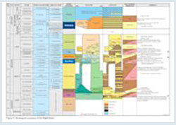
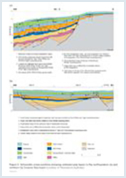
In 2000 Geoscience Australia introduced a new sequence stratigraphic framework for the Bight Basin, based on seismic and well control. Figure 3 shows the newly defined supersequences in relationship to the litho-stratigraphic units.
The oldest sediments in the basin, intersected in the Eyre Sub-basin, are fluvial and lacustrine sandstones and mudstones of Late Jurassic age and form part of the Sea Lion and Minke Supersequences, deposited during the early rift development stages. Although not penetrated by wells in the Ceduna and Duntroon sub-basins, seismic interpretation infers that a thick ?Jurassic succession may exist in these areas above Precambrian, Cambrian or ?Adelaidean basement.
The Jurassic upper crustal extension was followed by a period of thermal subsidence during the Early Cretaceous. The Berriasian Southern Right Supersequence was penetrated in Echidna 1 in the Duntroon Sub-basin, where it is represented by dark carbonaceous mudstone with interbedded gritty sandstone of the Echidna Formation grading into the lacustrine shale of the Neptune Formation.
In the Eyre and Ceduna sub-basins, the Southern Right Supersequence is represented by the fluvial sandy to shaly succession of the Loongana Formation. The fluviolacustrine succession is continued by the Valanginian to mid-Albian Bronze Whaler Supersequence, comprising mudstone, claystone, siltstone and minor coal of the Borda Formation in the Duntroon Sub-basin and the eastern part of the Ceduna Sub-basin.
Towards the central to northern parts of the Bight Basin, the Bronze Whaler Supersequence includes sandstone, silt and shale with wood fragments of the late Loongana Formation; glauconitic and carbonaceous rich claystone, sandstone, siltstone and shale of the Madura Formation; and claystone, siltstone and shales of the early parts of the Toondi Formation. Marine incursions were interpreted during the Albian, and appear more prevalent in the central to western areas, marking the beginning of a period of accelerated subsidence.
Thick deltaic and marine successions (up to 10 km) were deposited during the late Albian to Santonian (Blue Whale, White Pointer and Tiger Supersequences), due to a phase of accelerated subsidence culminating with the late Santonian breakup. In the Duntroon and Ceduna sub-basins, drilled lithologies consist of interbedded fluviodeltaic claystone and sandstone of the late Albian Ceduna Formation overlain by the sandstone, siltstone and coal of the Cenomanian Platypus Formation.
Towards the west, the facies shifts into nearshore fine sandstone and silt of ‘unit a’ and silty mudstone of ‘unit b’ in Potoroo 1 (northern Ceduna Sub-basin), and a claystone, siltstone and shale succession of the Toondi Formation on the Madura Shelf and in the Eyre Sub-basin. In distal areas of the Bight Basin, the lithologies are inferred to be more mud-dominated, based on the seismic geometries and character.
Maximum transgression occurred in the Santonian during which time prodelta shale and mudstone of the Wigunda Formation (as part of the Tiger Supersequence) were deposited. Transition from non-marine and paralic to marine sedimentation is marked in the eastern parts of the basin by the deposition of the Wombat Sandstone Member.
The late Santonian breakup was followed by another period of thermal subsidence. The increase in clastic sediment influx led to the deposition of the thick sand-dominated delta complexes of the Hammerhead
Supersequence in the Ceduna and Recherche sub-basins. Where drilled, the supersequence consists of amalgamated sandstone, interbedded claystone–sandstone and massive mudstone units of the Potoroo Formation, or its lateral equivalent on the platformal areas, the sandstone-dominant Nurina Formation. In the wells of the eastern Ceduna Sub-basin, the basal Hammerhead Supersequence includes shales of the Wigunda Formation.
A regional unconformity at the top of the Hammerhead Supersequence separates the Bight Basin from the thin transgressive sandstones and massive open-marine carbonates of the Tertiary Eucla Basin.
The Jurassic to Cretaceous succession in the Bight Basin contains a number of source intervals consisting of marine and non-marine carbonaceous shales, coals and oil shales.
Geoscience Australia assessed the distribution of the potential source intervals based on the regional sequence stratigraphic framework and the potential petroleum systems present, along with the regional palaeogeography and geochemical data from wells. Only minor oil and gas shows were encountered by wells to date, and the majority of intervals intersected in exploration wells are immature for oil generation. However, the source rock quality in the deeper parts of the basin is inferred to range from good to excellent and modelling shows that adequate maturities were reached to generate and expel liquid and gaseous hydrocarbons.
The Borda Formation facies of the Bronze Whaler Supersequence represents the richest and most oil-prone interval penetrated to date, both in terms of TOC and hydrogen index. Coal interbedded within the claystone commonly has HI values averaging between 210 to 330 mg HC/g TOC and TOC values up to 56%. By comparison claystone has average HI values in the range 120–170 mg HC/g TOC and TOC values up to 5.5%. Variations in source richness between wells for this important source unit are apparent and in general, source rock quality and quantity increases basinward of the Late Cretaceous hinge.
Considered part of the same petroleum system, organically rich fluviolacustrine shales occurring within the underlying Southern Right Supersequence (Loongana Formation) have TOC averaging 1.2% and Rock-Eval results that suggests low potential for generating liquid hydrocarbons. However, only a small number of samples were available; shales may be both thicker and more thermally mature in locations away from basement highs.
Shales of the Blue Whale Supersequence (Toondi and Ceduna formations) average 2.6% TOC, while the coals reach up to 62% TOC, with HI values up to 230 mg HC/g TOC for shales and 345 mg HC/g TOC for coals. Source rock quality in Platypus 1 is interpreted as excellent for both coaly and shaly lithologies. However, the best source rocks are expected to be found in the central Ceduna Sub-basin, where deep water, restricted marine environments of deposition are interpreted for this time. Dredging of upper Cenomanian-Turonian organic-rich marine rocks has confirmed the presence of high quality potential source rocks in this section. These rocks are mature in the central part of the Ceduna Sub-basin and are likely to have generated and expelled hydrocarbons since the Campanian.
Other important source intervals are the coal-prone Platypus Formation (and its ‘unit b’ equivalent in Potoroo 1) and the claystone of the basal Wigunda Formation, within the White Pointer and early Tiger Supersequences. In the inboard basin areas these intervals are volumetrically less significant and more gas prone, but the distal portions of these sections, in the outer Ceduna Sub-basin, are interpreted to be much thicker and more mature and they may have generated light oils.
Significant oil and gas shows in Greenly 1 in the Wigunda Formation are presumed to have been sourced from coaly intervals of the Borda Formation. The oil inclusions from Jerboa 1 are consistent with a (?Jurassic to ?Neocomian) lacustrine source rock and suggest a palaeo-oil column of potentially greater than 40 m. Together with the documented hydrocarbon seepage, these form the main direct indications of oil charge in the area.
Reservoir, seal and source potential of each unit are summarised in figure 3. As with the source rock presence and quality, because wells are mostly located on the basin margin, reservoir and seal distribution is interpreted by linking the well results to seismic data and inferred depositional models.
Fluviodeltaic sandstones of the Potoroo Formation have excellent reservoir potential (net to gross ratio of more than 70% and porosities over 35% in Potoroo 1, and well over 20% in Gnarlyknots 1A even below 3000 m), but they may lack an adequate regional seal. However, thick and laterally extensive claystone units within the Hammerhead Supersequence are likely to be present and provide intraformational seals. Interbedded marl and limestone of the overlying Eucla Basin may also have adequate sealing quality in some parts of the basin.
Other principal reservoir candidates are deltaic sandstones of the Ceduna and Platypus formations, where porosities of up to 30% have been encountered. Locally, marine sandstones of the Tiger Supersequence (Wigunda and Potoroo formations) also have excellent reservoir quality. Away from regional highs, prodelta mudstone of the Wigunda Formation provides an effective seal for these highly porous intervals.
Of secondary interest are fluviolacustrine lithologies intersected within the Loongana and lower Borda formations. Although of highly variable reservoir quality, these intervals have poor to moderate overall porosity, mainly due to the high depth of burial. Shales of the Madura and Toondi formations and intraformational shale of the Loongana Formation can provide adequate seal for these potential reservoirs. Major cap rocks exist in the Borda and Neptune formations.
Excellent quality reservoir rocks have been encountered in the overlying Eucla Basin, within the marine Wobbegong Supersequence (Pidinga Formation and Hampton Sandstone).
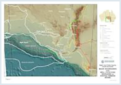
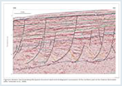
Given the relatively underexplored nature of the basin, potential plays have yet to be firmly established. However, potential plays include highly faulted, rotated and collapsed anticlinal structures, tilted fault blocks and unconformity traps on the flanks of the rotated anticlines (Fig. 6). Compaction drape of Cretaceous sediments over tilted basement blocks (e.g. Jerboa 1) is also common in the undrilled areas of the basin. The high degree of faulting and complexity of structures requires close grid, high-resolution seismic to adequately assess seal integrity.
Crestal erosion along basement highs (e.g. Echidna 1), due to tectonic uplift, has resulted in the development of significant stratigraphic traps. Opportunities for stratigraphic traps also exists beneath incised valley systems, like the ones mapped in the Ceduna Sub-basin at Santonian level.
Large complex and highly variable structures are located in water depths exceeding 1000 m which, although high risk, may have enormous hydrocarbon potential and remain largely unexplored.
There is no estimate of undiscovered resources.
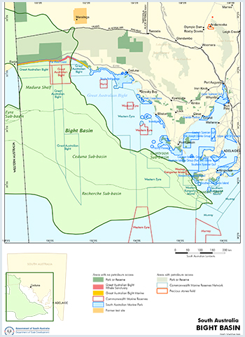
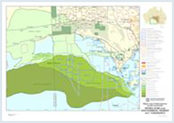
Several National Park and Wildlife reserves overlie the onshore Bight Basin. Exploration is permitted in the Nullarbor and Yellabinna Regional Reserves. Exploration is permitted in the Nullarbor and Yellabinna Regional Reserves. Exploration is permitted in part of the Nullarbor National Park that is subject to joint proclamation, although much of it is not available for access.The onshore portion of the Bight Basin underlies Maralinga Lands and Yalata Aboriginal Reserve. Maralinga people have expressed willingness to allow petroleum exploration on their lands, but this is not currently the case in the Yalata Reserve.
The Great Australian Bight Marine Park covers part of the offshore Bight Basin, extending 200 nautical miles from the coast to the edge of Australia’s economic zone. This park comprises two zones managed under state jurisdiction, and two zones that are under Commonwealth management.
Southward from the coast to 3 nautical miles is the state component of the park. This is divided into a Whale Sanctuary Zone (436 km2) at the Head of the Bight, and a National Park Zone (1247 km2) either side of that. At this stage, access for petroleum or minerals is limited to a small portion of the state park that was proclaimed under the Fisheries Act 1982. This access is limited to between 1 November and 30 April each year, when Southern Right Whales are not normally present in the area. However, there is a review of the Fisheries Act underway. It is expected that an outcome of this review will be the withdrawal of access for the resources industry for this portion of the park.
Oceanward of the 3 nautical mile zone is the Commonwealth part of the Great Australian Bight Marine Park (19 208 km2). A management plan for the Commonwealth Great Australian Bight Marine Park was released in 2000. This provided for two Commonwealth zones — a Marine Mammal Protection Zone (3830 km2, north of 31º47’S), and a 20 nautical mile wide Benthic Protection Zone (15 939 km2) from the state park to the edge of Australia’s Exclusive Economic Zone.
The Commonwealth Government has a policy not to release acreage for petroleum or mineral exploration within the Marine Mammal Protection Zone, effectively excluding access for the life of the current management plan.
The management plan does provide for petroleum exploration and development in the Benthic Protection Zone, pending assessment on a case-by-case basis. This is to ensure that the values of the park are not compromised. A review of this plan is currently underway. The draft plan available for public discussion indicates no significant change to access provisions for the Commonwealth part of the park, although there are some changes to assessment processes for proposals in the Benthic Protection Zone.
Figure 7 shows the licence status. See Holders of Petroleum and Geothermal Tenements in South Australia - P1 Sheet for more information.
Offshore Exploration Permits for Petroleum (EPPs)
All Offshore Petroleum Permit areas located beyond three nautical miles from the territorial sea baseline are administered by the National Offshore Petroleum Titles Administrator (NOPTA). Further information on permits administered by NOPTA is available via the National Electronic Approvals Tracking System (NEATS)
Bradshaw BE, Rollet N, Totterdell JM and Borissova I, 2003. A revised structural framework for frontier basins on the southern and southwestern Australian continental margin. Geoscience Australia. Record, 2003/03.
Hall, P.A., McKirdy, D.M., Grice, K ,, Edwards, D.S. 2014 Australasian asphaltite strandings: Their origin reviewed in light of the effects of weathering and biodegradation on their biomarker and isotopic profiles, Marine and Petroleum Geology, 57: 572-593
Hill AJ, 1995. Bight Basin. In: Drexel JF and Preiss WV eds, The geology of South Australia, Volume 2, The Phanerozoic. South Australia. Geological Survey. Bulletin, 54:133-137.
King SJ and Mee BC, 2004. The seismic stratigraphy and petroleum potential of the Late Cretaceous Ceduna Delta, Ceduna Sub-basin, Great Australian Bight. In: Boult PJ, Johns DR and Lang SC eds, PESA’s Eastern Australasian Basin Symposium II, Adelaide 2004. Petroleum Exploration Society of Australia. Special Publication, pp. 63-73.
Krassay AA and Totterdell JM, 2003. Seismic stratigraphy of a large, Cretaceous shelf-margin delta complex, offshore southern Australia. AAPG Bulletin, 87:203-219.
MacDonald J, Backe G, King R, Holford S and Hillis R.R. 2012 Geomechanical modelling of fault reactivation in the Ceduna Sub-basin, Bight Basin, Geological Society London Special Publications, v. 367, p. 71-89.
Messent, B.E.J., 1998. Great Australian Bight well audit. Australian Geological Survey Organisation. Record, 1998/37.
Messent, B.E.J., Wilson, C. and Flynn, K., 1996. Assessment of the seal potential of Tertiary carbonates, Duntroon Basin, South Australia. APPEA Journal, 36(1):233-241.
O’Brien, G.W., Paraschivoiu, E. and Hibburt, J.E. (Eds). The petroleum geology of South Australia. Volume 5: Great Australian Bight, South Australia. Department of Primary Industries and Resources. Petroleum Geology of South Australia Series.
Smith MA and Donaldson IF, 1995. The hydrocarbon potential of the Duntroon Basin. APPEA Journal, 35(1):203-219.
Somerville R, 2001. The Ceduna Sub-basin — a snapshot of prospectivity. APPEA Journal, 41(1):321-346.
Stagg HMJ, Cockshell CD, Willcox JB, Hill AJ, Needham DJL, Thomas B, O’Brien GW and Hough LP, 1990. Basins of the Great Australian Bight region: geology and petroleum potential. Bureau of Mineral Resources, Geology and Geophysics, Australia. Continental Margins Program Folio, 5. Note: this publication is out of print.
Struckmeyer HIM, Totterdell, JM, Blevin JE, Logan GA, Boreham CJ, Deighton I, Krassay AA and Bradshaw MT, 2001. Character, maturity and distribution of potential Cretaceous oil source rocks in the Ceduna Sub-basin, Bight Basin, Great Australian Bight. In: Hill, K.C. and Bernecker, T. (Eds), Eastern Australasian Basins Symposium, A refocused energy perspective for the future, Melbourne, 2001. Petroleum Exploration Society of Australia. Special Publication, pp. 543-552.
Totterdell JM, Blevin JE, Struckmeyer HIM, Bradshaw BE, Colewll JB and Kennard JM, 2000. A new sequence framework for the Great Australian Bight: starting with a clean slate. APPEA Journal, 40(1):95-117.
Totterdell JM and Krassay AA, 2003. Sequence stratigraphic correlation of onshore and offshore Bight Basin successions. Geoscience Australia. Record, 2003/02
For more information, contact:
-
Geoscience Australia has the latest information on Australia’s offshore basins:
Bight Basin | Geoscience Australia
Energy Resources Division
DEM.Petroleum@sa.gov.au -
Refer to NOPIMS for up to date offshore well information:
National Offshore Petroleum Information Management System (NOPIMS)