
Page last updated April 2026
On this page
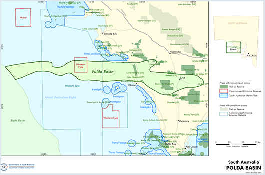
Polda Basin Acreage Release 2025
One new Regulated Substances Exploration Licence (RSEL) in the Polda Basin was offered as acreage release block PO2025 RSEL-A by the South Australian Government for competitive work program bidding, with applications closing on 31 October 2025.
The Polda Basin is a Neoproterozoic - Jurassic basin.
The Polda Basin contains sediments which range in age from Neoproterozoic to Jurassic, overlies the Itiledoo Basin and is overlain by a thin veneer of Tertiary sediments.
Summary
| Age | Neoproterozoic - Jurassic |
|---|---|
| Area in South Australia | 10,000 km2 (3,860 sq miles) of which around half is onshore |
| Depth to target zone | Up to 2,000 m |
| Thickness | Up to 2,000 m |
| Hydrocarbon shows | Oil staining in Jurassic sandstones in Kilroo 1A core |
| First commercial discovery | None |
| Identified reserves | Nil |
| Undiscovered resources (50%) | Not determined |
| Production | Nil |
| Basin type | Intracratonic graben or rift valley |
| Depositional setting | Alluvial, glacial, volcanic and evaporitic |
| Reservoirs | Clastic, evaporitic, volcanic |
| Regional structure | Complex dextral wrench faults, diapirs (Neoproterozoic); tensional (Mesozoic) |
| Seals | Continental claystones, evaporites |
| Source rocks | Continental claystones, coals, evaporites |
| Number of wells | 3 offshore, 5 stratigraphic onshore, numerous coal wells, water wells and mineral drillholes onshore |
Seismic line km | 111 2D onshore; 3,380 2D offshore |
Figures
Prospectivity
The intracratonic Polda Basin is an elongate easterly trending trough that extends for at least 350 km from the Eyre Peninsula to the centre of the Great Australian Bight. It ranges from 10 to 40 km in width and has a water depth that varies from 50 to 200 m at the western end of the basin. The Polda Basin contains sediments which range in age from possible Neoproterozoic to Jurassic, overlies the Paleo- to Mesoproterozoic Itiledoo Basin and is overlain by a thin veneer of Tertiary sediments.
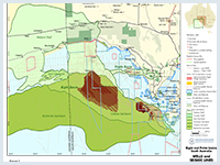
The Polda Basin has been explored for coal, uranium and petroleum. Petroleum exploration focussed on the offshore central Polda Basin following the discovery of the basin by the Shell aeromagnetic survey in 1966. 2D seismic data was acquired by Shell and Bridge Oil, who subsequently identified drilling targets. Gemini 1 was the first petroleum well drilled in 1975 by Outback Oil, while Mercury 1 and Columbia 1 were drilled by Australian Occidental in 1981–82. There has been no exploration carried out since 1982, except for five seismic lines (totalling 125 km within the offshore Polda Basin) obtained as part of a 1986 survey by the Bureau of Mineral Resources (BMR; now Geoscience Australia) and three seismic lines extending into the basin (104 km within the offshore Polda Basin) shot in 1998 by GHD Surveys Pty Ltd. One PEL application is current over the southern portion of the onshore basin and one immediately offshore, and two GSELs cover the whole of the onshore portion of the basin.
The Jurassic Polda Formation contains the Lock Coal Deposit. Coal exploration, centred on the Lock Sub-basin, has delineated 260 Mt of sub-bituminous coal in the measured-indicated category, with a proximate analysis of 26% moisture, 23% ash, 30% volatile matter, and 21% a fixed carbon. The average heat value of 14.6 MJ/kg is typical of South Australian coals.
| WELL/DRILLHOLE | DATE | TYPE | ON/OFFSHORE | PEPS | SARIG |
|---|---|---|---|---|---|
| Colton 1 | 1976/77 | Stratigraphic | Onshore | Link | Link |
| Columbia 1 | 1982 | Hydrocarbon | Offshore | Link | Link |
| Gemini 1 | 1975 | Hydrocarbon | Offshore | Link | Link |
| Kilroo 1A (CRA 83 KD-1A) | 1984 | Mineral | Onshore | Link | Link |
| Lock 1 | 1980 | Stratigraphic | Onshore | Link | Link |
| Mercury 1 | 1981/82 | Hydrocarbon | Offshore | Link | Link |
| Mucka Cudla 1 | 1976 | Stratigraphic | Onshore | Link | Link |
| Polda 1 | 1965 | Water | Onshore | N/A | Link |
| P 21 (Polda 21) | 1977 | Coal | Onshore | N/A | Link |
| Tuckey 1 | 1976 | Mineral | Onshore | Link | Link |
entX Limited was granted gas storage permits GSEL 781 and 784 in 2023.
The Polda and Itiledoo basins are underlain by a suite of Archean and earliest Proterozoic crystalline basement rocks of the Gawler Craton known as the Sleaford Complex (~2560 – 2470 Ma), which together with the Mulgathing Complex in the northern Gawler Craton was probably part of an adjoining basin now dismembered by Paleoproterozoic tectonism (Gawler Craton | Energy & Mining). The Sleaford Complex contains a diverse range of metamorphosed and deformed rocks, of which granites and iron-rich mafic rocks may form potential natural hydrogen source rocks on Eyre Peninsula.
The Sleaford Orogeny was followed by approximately 400 Ma of tectonic quiescence in the eastern Polda Basin area. Late Paleoproterozoic extension led to widespread basin formation across the Gawler Craton, associated with sedimentation and bimodal magmatism. The Hutchison Supergroup (<2000 – 1770 Ma) comprises quartzite, dolomite, iron formation, schist and amphibolite, deposited in a passive margin setting. The Hutchison Supergroup was subsequently intruded by the Middle granites of the Peter Pan Supersuite (1745 – 1700 Ma) as part of the Kimban Orogeny, also likely to be good potential source rocks for hydrogen.
Juvenile felsic to mafic magmas of the St Peter Suite (1650 – 1610 Ma) occur over the northwest of the onshore Polda area, formed broadly in a continental magmatic arc setting.
Another period of extension occurred in the Polda area at the end of the Paleoproterozoic, leading to localised sedimentation and magmatism in the Itiledoo Basin (named by Flint and Rankin 1991) with a maximum age of approximately 1605 Ma inferred by radiometric dating of detrital zircons (Australian Stratigraphic Units Database). Deposition of sandstone, minor grit and pebble beds forming the Blue Range Beds (an equivalent of the Corunna Conglomerate shown in Figure 3) were reworked products of the Proterozoic and Archean basement so are likely to be a good source for natural hydrogen. The Blue Range Beds are exposed within the Polda Basin at Mount Wedge, approximately 13 km to the southeast of Mucka Cudla 1.
Soon after deposition of the Blue Range Beds the region was intruded by granites of the Hiltaba Suite, thought to be the source of the natural hydrogen encountered on the Yorke Peninsula. No Hiltaba Suite granite has been intersected in the Itiledoo Basin to date, although just to the north of the Polda Basin the granite encountered in Wudinna 1 was dated as 1519 ± 67 Ma, although Flint and Rankin (1991) expect that the true age is more likely to be 1600 – 1580 Ma. No zircons from the Hiltaba granite have been sampled from the Blue Range Beds, although zircons from the St Peter Suite do occur, indicating that the intrusion was post-deposition in the Itiledoo Basin.
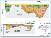
The Polda Basin contains sediments which range in age from possibly Neoproterozoic to Jurassic, unconformably overlying the Itiledoo Basin with an age gap of at least 600 million years (Figures 2 and 3). The whole section was penetrated at the onshore drillhole Kilroo 1A or CRA83 KD1A and comprises from the base, the Kilroo Formation, a volcanic, evaporitic, red bed sequence, overlain unconformably by the Permian-Carboniferous glacial Coolardie Formation and again unconformably overlain by the Jurassic Polda Formation. An unconformity separates the Jurassic from unconsolidated siliciclastic Cainozoic above. Figure 3 summarises the basin stratigraphy.
The age of the Kilroo Formation is uncertain, but it is thought to have been deposited during the Neoproterozoic. A recent review of the conventional core from Kilroo 1A (Tiainen 2025) indicates the formation comprises variably red-brown-grey-white interbedded arkoses, siltstones, claystones and at least two basalt flows and minor anhydrite and rare salt. From prior dating (Flint et al. 1988) the lower basalt is dated as Neoproterozoic from three samples and the shallower basalt is dated as Neoproterozoic, Silurian and Triassic from four samples. The sedimentary features observed in the core including mud drapes, bi-directional bedding, syneresis cracks, and possible low diversity bioturbation have been interpreted as indicating deposition on in an inter to supra tidal coastal plain gross depositional environment. Massive halite with minor interbeds of siltstone, claystone, dolomite and limestone extends for approximately 1700 m was penetrated offshore in Mercury 1 in 1981/2 (Well Completion Report (WCR) and Composite Log available in PEPS).
The Coolardie Formation unconformably overlies the Kilroo Formation and primarily consists of diamictite deposited in a terminoglacial environment. The thickness of the formation is variable, ranging offshore from 37 m at Gemini 1 to 87 m at Mercury 1. Based on palynology (Flint and Rankin 1981) the formation is correlative with deposition during the Gondwana Carboniferous-Permian glaciation.
The overlying Polda Formation is interpreted to have been deposited in an alluvial plain gross depositional environment (GDE) in response to the extensional tectonism that eventually led to the breakup of Gondwana, via reactivation of the deep basement bounding faults. In its type section in SADME Polda 1 (Flint and Rankin 1991) the Polda Formation comprises sandstone and carbonaceous and lignitic claystone around 86 m thick. In the Lock Sub-basin, the unit is divided into three intervals (Gatehouse 1995): a basal dark grey claystone with subangular ‘floating’ sand grains, a middle dark grey to black carbonaceous claystone with lignite, siltstone and fine-grained sandstone interbeds, and an upper dark brown and grey, medium to coarse-grained, angular to subangular and pyritic sandstone. Within the Lock Sub-basin, subbituminous coal seams up to 15 m thick are present. Similar coal seams and other lithotypes were intersected in drilling offshore and in the Kilroo Sub-basin. Coal seams pinch out abruptly towards basin margins to the north and south. In the offshore the formation is subdivided into two intervals, with the lower zone being sand-prone with regular interbeds of coal and siltstone, while the upper zone is dominated by claystone, siltstone and fining upward sandstone. The thickness of the formation ranges from 450–500 m in Columbia 1 and Mercury 1 but is highly variable across the basin.
Sedimentary structures in the Polda Formation include crossbedding, upward-fining sequences, and channelling. Poor sorting in coarser grained sandstone and conglomerate, with better sorting in finer grained intervals, and clay units beneath coal seams and within fine-grained sandstone beds, indicate a fluvial environment. The age of the Polda Formation is late Middle to Late Jurassic based on the presence of palynoflora from the Murospora florida Zone (Gatehouse 1995).
The depositional environment is interpreted as a broad valley with relatively low relief in which streams provided lateral mudflats, oxbow lakes and swamps in which coal accumulated. Lateral streams from the valley sides may have provided coarser grained sediments. The known distribution of the Polda Formation along the length of the graben (400 km) contrasts with a width of only 20–60 km. The recent review of Kilroo 1A confirms similar lithologies, and additionally micro conglomerates and variably pedogenically altered siltstones. Low angle planar cross beds dominate the micro conglomerate and arenite lithologies and support the fluvial plain interpretation. However, the lack of preserved vertical accretion deposits suggest an anastomosing channel habit rather than meandering, at least at this well. The finer fraction, siltstone and variably carbonaceous-coaly claystone represent vertical accretion and floodplain/mire deposits.
Interestingly no Cretaceous sediments comparable to those in the Bight and Duntroon Basins have been intersected in the Polda Basin, as the Polda Formation is overlain by a thin veneer of Cainozoic sediments, including the sequence of unconsolidated sands and claystones with a lignite base of the Eocene Poelpena Formation. The onshore portion of the Polda Basin is subdivided into the Lock Sub-basin and the Kilroo Sub-basin, containing up to 1500–2000 m of Neoproterozoic to Jurassic sediments in the eastern and western ends but only 500 m in the centre.
Reservoirs
Potential reservoirs include clastic sandstones and conglomerates in the Polda, Coolardie and Kilroo Formations. Reservoir potential has been demonstrated to be fair to excellent in several intervals (refer to WCRs in PEPS) and are summarised below.
- Reservoir quality is excellent, particularly in the poorly consolidated porous and permeable Jurassic Polda Formation.
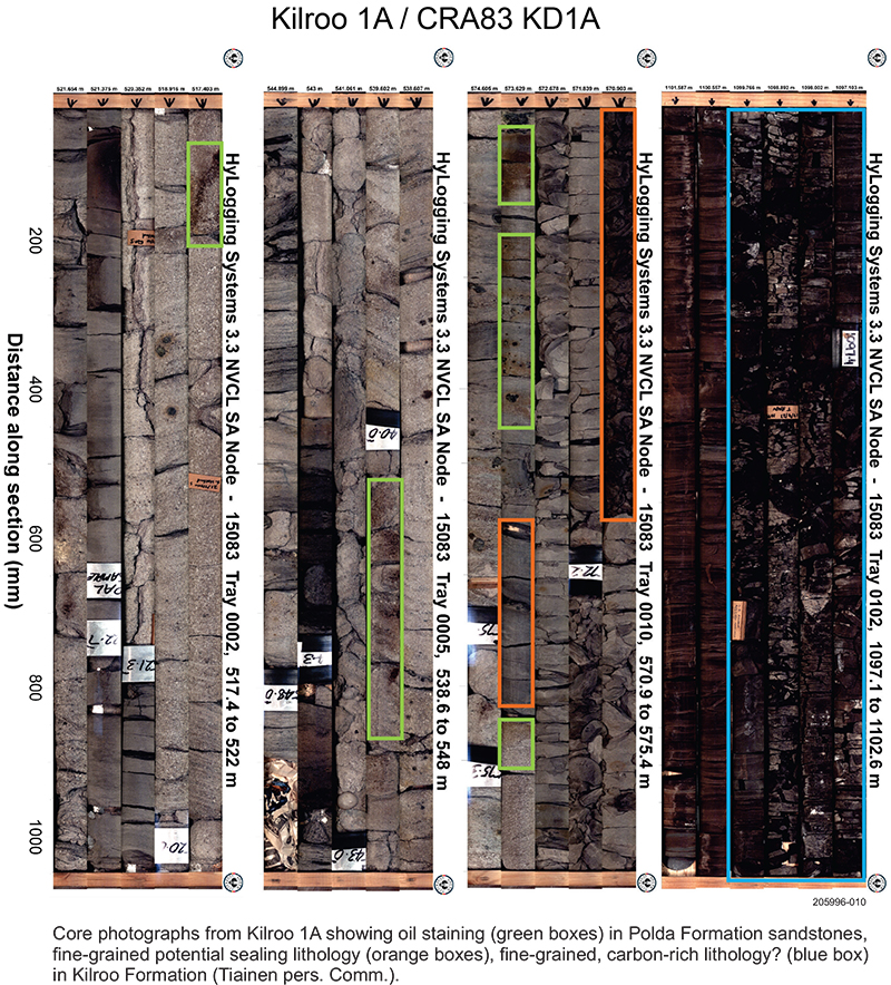
- The onshore Kilroo 1A drillhole shows oil stained, relatively unconsolidated and coarse-grained lithic to sub-lithic arenites in the Polda Formation, which based on sedimentary structures is interpreted as indicating deposition in an alluvial-delta plain gross depositional environment (Figure 4).
- Sandstone intervals in Mercury 1 have vertical porosity distribution ranging for 0% to 25%, with a mean of 10.9%.
- Those in Columbia 1 range from 0.7% to 29.5%, with a mean of 13.2%.
- Reservoirs of variable quality are present in the Permian Coolardie Formation.
- Neoproterozoic Kilroo Formation:
- Log-derived porosities of up to 19% were recorded from the cleaner sandy intervals in Columbia 1, with thick quartzose sandstones in the basal sequence with porosities in the range 10–15% despite extensive silicification, although SP logs suggest that they might have limited permeability.
- In Mercury 1 thin sandstone intervals in the top of the Proterozoic section had maximum log-derived porosities of 18%, whereas thick sandstone beds in the basal sequence showed porosities of around 13%.
Seals
Claystone of the Polda Formation, claystone and diamictite of the Coolardie Formation and evaporites of the Kilroo Formation are all potential seals. Figure 2 shows that there was a significant thickness of halite intersected within the Kilroo offshore in Mercury 1, which may be a promising site for underground hydrogen storage according to Feitz et al. (2022) and Bradshaw et al. (2023). Thinner sections of halite may be present onshore and provide suitable seals for reservoirs. Figure 2 also shows that mafic volcanics consisting of tuffs and basalt were encountered at two levels in the mineral exploration borehole CRA 83 KD-1A, designated as Kilroo 1A in the Petroleum Exploration and Production System — South Australia; these may act as suitable seals for potential reservoirs below.
Oil and Gas source rocks
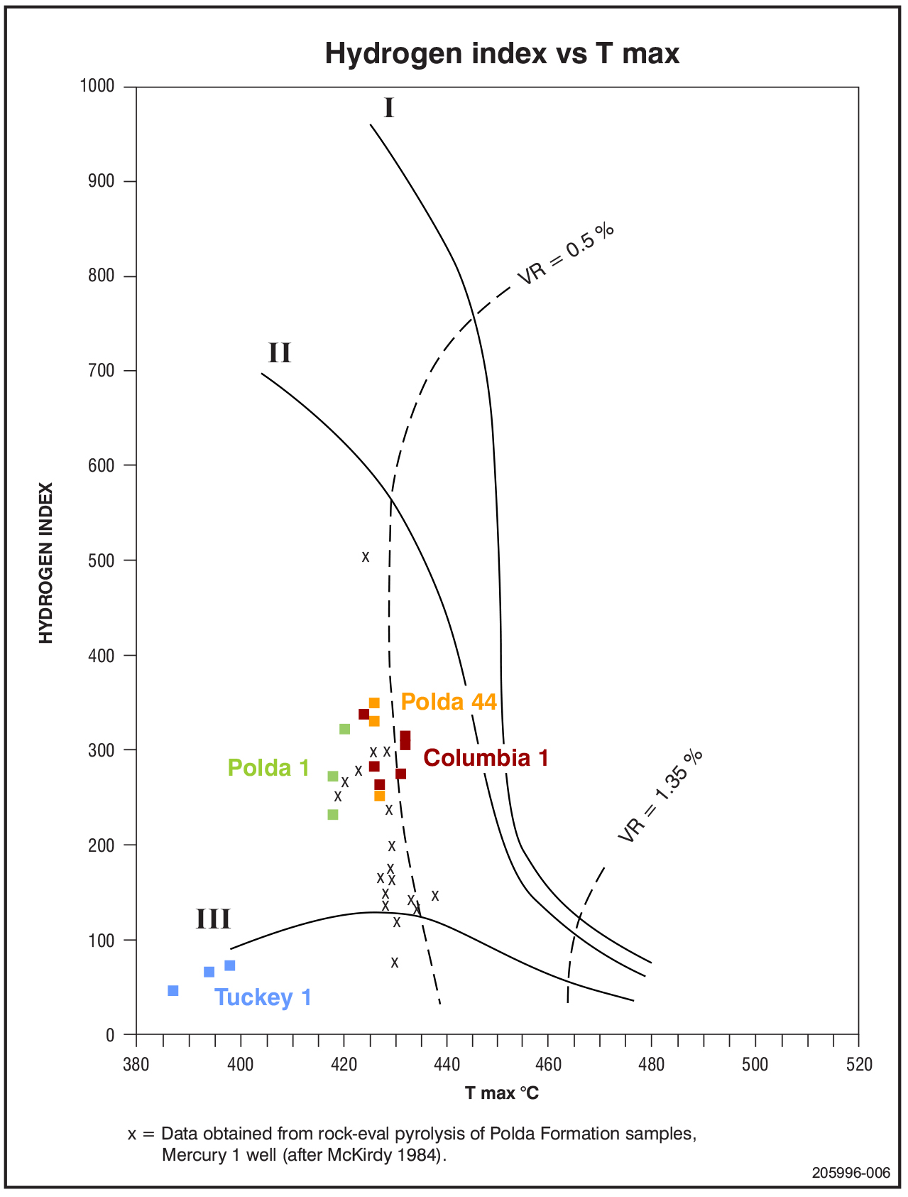
The hydrocarbon potential of the Polda Formation has been assessed as having good TOC values (2.5–55%) and fair to excellent generative potential (2.97 to 126 kg/t). However, vitrinite reflectance values suggest that the currently drilled portions of the basin are immature for hydrocarbon generation and that maturity will only be reached at considerable depth, either on the flanks of the central Polda Basin or to the west, where potential Mesozoic source and reservoir rocks may be present.
The Polda Formation has good source potential in the upper Jurassic coals, with similar characteristics to the Jurassic Walloon Coal Measure of the Eromanga, Surat and Clarence-Moreton Basins (Jong 1991; Figure 5).
Kilroo and Coolardie formations, where drilled to date, are devoid of source rocks.
Natural Hydrogen source rocks
Natural hydrogen has been detected in wells in the Cooper and Eromanga Basins, Otway Basin and Stansbury Basin in South Australia.
The natural hydrogen industry is in its infancy worldwide. However, South Australia is at the forefront of exploration for natural hydrogen with granted PELs being actively explored, including PEL 691 on eastern Eyre Peninsula, and over 40 PEL applications.
Several mechanisms for the generation of natural hydrogen in the subsurface have been proposed, summarised in Natural hydrogen | Energy & Mining and Bendall (2022).
There has been no petroleum or hydrogen exploration in the release area hence understanding of trapping mechanisms is limited. However, the deep-seated, east-west striking boundary faults of the Polda Basin have probably been active since the Archean, exerting a primary control on basin development during the Mesoproterozoic (Itiledoo Basin) and Neoproterozoic. Reactivation during Mesozoic rifting of Australia’s southern margin from Antarctica have had further impact on trap generation.
Potential plays onshore include unconformity traps at the top of the Kilroo Formation, intra-graben horsts, monoclinal drape features and clastic aprons adjacent to the steep southern boundary fault in particular. Salt-associated traps have been demonstrated in the offshore portion of the Polda Basin and may exist onshore although to a lesser extent due to a likely much thinner salt section.
Offshore, Mercury 1 tested an anticlinal closure above an interpreted halite pillow (Feitz et al. 2022; Figure 2) and may extend inboard to the onshore. Columbia 1 was designed to test a large horst structure in the western sector of the Polda Basin. Gemini 1 was terminated before reaching the target sequence. All three wells were considered to be valid hydrocarbon plays with significant vertical closures.
The deep-seated, east-west striking boundary faults of the Polda Basin have probably been active since the Archean, exerting a primary control on basin development during the Mesoproterozoic (Itiledoo Basin) and Neoproterozoic. They were then reactivated during Mesozoic extension of Australia’s southern margin and have had an impact on generating potential traps. They may have acted as long-lived conduits for circulation of fluids and gases and hence as pathways for any generated hydrocarbons and/or hydrogen to migrate towards potential traps.
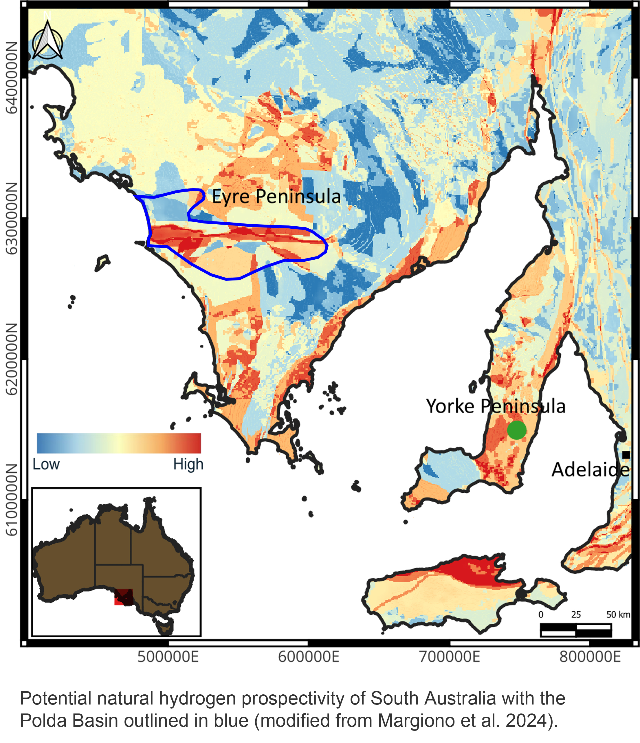
Figure 6 shows a prospectivity map for natural hydrogen in South Australia, generated from analysis of potential hydrogen source rocks, potential migration pathways (faults, dykes and permeable lithologies) and known trapping mechanisms such as evaporites, clay, dolerite, and basin structure (Rumi Daruso 2023, shown in Margiono et al. 2024). This suggests that there is potential for natural hydrogen accumulation within portions of the onshore Polda Basin.
There is no estimate of undiscovered resources.
Several National Parks and Wildlife reserves are scattered over the onshore portion of the Polda Basin (South Australia Reserved Land figure). Exploration is not permitted in several of these.
Figure 7 shows the licence status at the time of publication.
Information on holders of petroleum tenements in South Australia (PDF)
BENDALL B 2022. Current perspectives on natural hydrogen: a synopsis. MESA Journal 96, pp 37–46, Department for Energy and Mining, South Australia.
BOREHAM CJ, EDWARDS DE, CZADO K, ROLLET N, WANG L, VAN DER WIELEN S, CHAMPION D, BLEWETT R, FEITZ A and HENSON PA 2021. Hydrogen in Australian natural gas: occurrences, sources and resources. The APPEA Journal 61:163–191. https://doi.org/10.1071/AJ20044
BRADSHAW M, REES S, WANG L, SZCZEPANIAK M, COOK W, VOEGELI S, BOREHAM C, WAINMAN C, WONG S, SOUTHBY C and FEITZ A 2023. Australian salt basins – options for underground hydrogen storage.The APPEA Journal 63:285–304. https://doi.org/10.1071/AJ22153
CHRISP GM and PEARCE TA 2015. Petroleum Exploration Licence no. 126 Annual Report Licence Year 1 – Resubmitted. Energy Exploration Pty Ltd.
CURTIS S and REID A 2017. Timing and provenance of the Itiledoo Basin, central Eyre Peninsula. Geological Survey of South Australia Discovery Day Conference 2017, Adelaide, South Australia.
DARUSO R 2023. Mapping Natural Hydrogen Prospectivity in SA: Assisting Energy Transition in the Minerals Industry. SAEMC 2023 conference. http://dx.doi.org/10.13140/RG.2.2.16960.85768
DREXEL JF and PREISS WV (eds) 1995. The geology of South Australia. Vol. 2, The Phanerozoic. Geological Survey of South Australia. Bulletin 54.
FEITZ AJ, WANG L, REES S and CARR L 2022. Feasibility of underground hydrogen storage in a salt cavern in the offshore Polda Basin. In: K CZARNOTA (ed.) Exploring for the Future: Extended Abstracts, Geoscience Australia, Canberra.
FLINT RB 1993. Itiledoo Basin. In JF DREXEL, WV PREISS and AJ PARKER 1993. The geology of South Australia, Volume 1, The Precambrian, South Australia Geological Survey, Bulletin 54.
FLINT RB and RANKIN LR 1991. KIMBA, South Australia, sheet SI/53-07. 1:250 000 Series — Explanatory Notes. Geological Survey of South Australia.
FLINT R.B., FANNING C.M. and RANKIN L.R. 1988. The Late Proterozoic Kilroo Formation of the Polda Basin. Geological Survey of South Australia, Quarterly Geological Notes No. 106: 16-23
GATEHOUSE CG 1995. Polda Basin. In Drexel JF and Preiss WV (Eds). The geology of South Australia. Vol. 2, The Phanerozoic. Geological Survey of South Australia. Bulletin 54, Chapter 9, pp 130–133.
GEOSCIENCE AUSTRALIA. Australian Stratigraphic Units Database. Australian Government.
HOLFORD S, DUDDY I, HILLIS R and STOKER M 2024. Thermochronological constraints on the tectonic history of the Polda Basin. Australian Energy Producers Journal 64(S1):S398–S401. https://doi.org/10.1071/EP23183
JONG JTS 1991. The source and reservoir potential of the Late Jurassic Polda Formation, Polda Basin, SA. University of Adelaide. National Centre for Petroleum Geology and Geophysics. BSc (Hons) thesis (unpublished).
MARGIONO R, DARUSO R, GUBINA A and HEINSON G 2024. 3D MT mapping of natural hydrogen prospectivity in South Australia. Presentation at The Natural Hydrogen Association of Australia’s inaugural conference.
NELSON RG, CRABB TN and GERDES RA 1986. A review of geophysical exploration in the Polda Basin, South Australia. APEA Journal 26(1):319–333. https://doi.org/10.1071/AJ85028
O’BRIEN GW, PARASCHIVOIU E and HIBBURT JE (Eds) 2012. The petroleum geology of South Australia. Volume 5: Bight Basin. Department of Primary Industries and Resources South Australia.
SEARS H 1980. Source-rock studies – SA sedimentary basins. Progress report no. 44 of SADME Project 11.06.368. Department of Mines and Energy, South Australia.
STAGG HMJ, COCKSHELL CD, WILLCOX JB, HILL AJ, NEEDHAM DJL, THOMAS B, O’BRIEN GW and HOUGH LP 1990. Basins of the Great Australian Bight: Geology and Petroleum Potential. Bureau of Mineral Resources, Geology and Geophysics, Australia. Continental Margins Program Folio, 5.
STAGG HMJ, WILLCOX JB and NEEDHAM DJJ 1992. The Polda Basin — a seismic interpretation of a Proterozoic–Mesozoic rift in the Great Australian Bight. BMR Journal of Australian Geology and Geophysics 13:1–13.
TIAINEN, S. 2025. DEM Kilroo 1A Core Review April 2025 1-500. PEPS - Kilroo 001A
WATSON BL 1991. Results of total organic carbon and Rock-Eval pyrolysis determinations of source rock potential yield, performed on selected drill cuttings and core samples taken from drillholes SADME Polda 1, SADME Polda 44, Australia Occidental Petroleum Columbia 1 and SADME Tuckey 1. Amdel Core Services Pty Ltd report no. 009/1240; MESA no. 8496 R 1. Department of Mines and Energy, South Australia.
WISE T 2019. Prospectivity modelling of the Olympic Cu–Au Province. Department for Energy and Mining. MESA Journal 90, pp 36–41