
On this page
 The Simpson Basin is an Triassic basin.
The basin overlies Palaeozoic and older basins and is overlain by the Eromanga Basin (Jurassic to Cretaceous).
Simpson Basin plays
Summary
| Age | Triassic |
|---|---|
| Area in South Australia | 34 100 km2 (13 166 sq miles) |
| Depth to target zone | 2000-2600m |
| Thickness | Up to 300m |
| Hydrocarbon shows | Peera Peera Formation (shows in 8 wells in South Australia) |
| First commercial discovery | None |
| Identified reserves | Nil |
| Undiscovered resources (50%) | Not determined |
| Production | Nil |
| Basin type | Intracratonic |
| Depositional setting | Non-marine |
| Reservoirs | Meandering fluvial sandstone |
| Regional structure | N-S faulted anticlines in sag basin |
| Seals | Lacustrine and overbank sediments |
| Source rocks | Underlying Pedirka Basin siltstone and shale; Peera Peera Formation siltstone and shale |
| Number of wells in SA | 10 |
Seismic line km in SA | 7228 2D |
Prospectivity
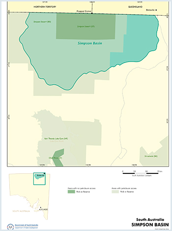
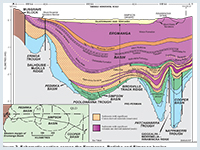
The Simpson Basin extends over ~57 500 km2 in South Australia and the Northern Territory (over half lies in South Australia). It is a circular, poorly defined depression with one major depocentre, the Poolowanna Trough. The basin overlies Palaeozoic and older basins and is overlain by the Eromanga Basin (Jurassic to Cretaceous).
During the Triassic, the western Pedirka Basin area remained elevated and was eroded, while the eastern portion subsided to form a depocentre, the Poolowanna Trough. Regional uplift and erosion terminated deposition in the Simpson Basin at the end of the Early to Middle Triassic. The main episode of structuring occurred in the Early Tertiary, when E–W compression produced major meridional faulted anticlines.
Petroleum exploration commenced in the 1950s when licences covering the Cooper and Eromanga basins were first acquired by Santos, who went against conventional wisdom that commercial accumulations of oil would not be found in Mesozoic formations within the Great Artesian Basin.
Initial exploration involved surface mapping, stratigraphic drilling, aerial surveys, gravity and aeromagnetic surveys and seismic. The first petroleum well was drilled in 1959 and Cooper Basin gas was discovered in 1963.
A second round of activity occurred from 1969–79, when five seismic surveys were carried out and one well was drilled. A seismic survey in 1971 revealed an eastward thickening sediment package between the eastern Pedirka Basin and the Eromanga Basin. The postulated Triassic age for these sediments was confirmed when Poolowanna 1 recovered oil from this sequence in 1977. The interval was subsequently defined as the Simpson Basin
Exploration activity intensified in the Poolowanna Trough/Pedirka Basin area in the 1980s in response to the Poolowanna discovery. Six petroleum wells have penetrated the Simpson Basin and over 11 000 km of seismic acquired in the 1970s and 1980s by Delhi–Santos.
Seismic reinterpretation by Santos indicated that five of the previously drilled wells in the region were not valid structural tests being outside closure at all objectives. Of the 1985 wells, Oolarinna 1 had no independent fault closure and Glen Joyce 1 had little closure.
It should be noted that no wells have been drilled in the South Australian sector since the 1980s, although Central Petroleum drilled Blamore 1 and Simpson 1 in the Northern Territory in 2008. Exploration in the area would benefit from current ideas on the geology of the petroleum systems in the Cooper Basin region and modern technology and interpretation techniques.
Hydrocarbon shows have been recorded in most wells within the Pedirka Basin region. However, oil and gas has been recovered from only 2 wells, the Poolowanna and Peera Peera Formations in Poolowanna 1, and the Poolowanna Formation in Poolowanna 3.
The classification scheme used by Geoscience Australia has been used to determine the type of show present in a formation in the tables below.
Hydrocarbon shows and flow rates in South Australian wells in the Poolowanna Trough/Simpson Basin/Pedirka Basin region:
| Well | Year/Result | Formation | Shows/Recovery | Flow rate |
|---|---|---|---|---|
| Pandieburra 1 |
1963 Oil shows | Peera Peera (?) | Minor fluorescence | |
| Dullingari Group | Minor fluorescence. Recovered 190ft mud-cut water with a trace of hydrocarbons. | |||
| Mokari 1 |
1966 Dry hole | Poolowanna | Gas show; mudlog gas 14 times background. Minor fluorescence. Water to surface (WTS) in 12 mins. | 387 cu ft/hr = rate of 1,654BWPD |
| Purni | Minor fluorescence. WTS in 17 mins. | Reported rate of 387 cu ft/hr | ||
| Poolowanna 1 |
1977 Oil shows | Poolowanna | Gas to surface (GTS) in 125 mins. Oil and water to surface in 3hrs 55 mins. Recovered 71¼ barrels water and 9½ barrels oil, 36.9o API gravity, with pour point of 41o C. | Gas at rate too small to measure (RTSTM). Calculated flow rate of 96BOPD |
| Peera Peera | Oil show. GTS in 120mins. Recovered 110ft mud and condensate. | Gas at RTSTM | ||
| Walkandi 1 |
1981 Oil shows | Poolowanna | Oil shows. Recovered 650ft muddy water and 1450ft gas-cut slightly muddy water. | |
| Peera Peera | Oil shows. Recovered 46ft rat hole mud and 31ft slightly gas-cut mud. | |||
| Walkandi | Oil shows. Recovered 480ft water cushion and 4900ft slightly gas-cut mud. | |||
| Erabena 1 |
1981 Oil shows | Poolowanna | Minor fluorescence | |
| Peera Peera | Minor fluorescence | |||
| Kuncherinna 1 |
1981/2 Oil shows | Poolowanna | Recovered 90ft rathole mud with trace of oil | |
| Peera Peera | Minor fluorescence | |||
| Poolowanna 2 |
1985 Oil shows | Wallumbilla | Minor fluorescence | |
| Cadna-owie | Minor fluorescence | |||
| Algebuckina | Minor fluorescence | |||
| Poolowanna | Minor fluorescence. Recovered 1026ft VSGCMW, 306ft SGCM. | |||
| Peera Peera | Minor fluorescence. Recovered 240ft very slightly gas-cut muddy water. | |||
| Oolarinna 1 |
1985 Dry hole | Poolowanna | Minor fluorescence | |
| Peera Peera | Recovered 5310ft gas-cut water (slightly muddy at top) | |||
| Killumi 1 |
1985 Dry hole | Poolowanna | Minor fluorescence | |
| Miandana 1 |
1985 Oil shows | Poolowanna | Minor fluorescence | |
| Poolowanna 3 |
1989 Oil shows | Algebuckina | Minor fluorescence | |
| Poolowanna | Minor fluorescence. GTS in 141 mins. Recovered 5550ft slightly oil and gas-cut water and 2290ft water in 171 mins. | Gas at RTSTM. 80BWPD. | ||
| Peera Peera | Minor fluorescence |
Hydrocarbon shows in Northern Territory wells in the Poolowanna Trough/Simpson Basin/Pedirka Basin region:
| Well | Year/Result | Formation | Shows/Recovery |
|---|---|---|---|
| McDills 1 | 1965 Trace hydrocarbon indication | Purni | Minor fluorescence |
| Colson 1 | 1978 Trace hydrocarbon indication | Poolowanna | Minor fluorescence |
| Peera Peera | Minor fluorescence | ||
| Warburton | Log interpretation “oil show” | ||
| Thomas 1 | 1981 Oil indication | Poolowanna | Residual oil. Recovered 4951ft water with minor mud in 68 mins. |
| Poeppels Corner 1 | 1984 Trace hydrocarbon indication | Algebuckina | Minor fluorescence |
| Poolowanna | Minor fluorescence | ||
| Peera Peera | Minor fluorescence | ||
| Beachcomber 1 | 1988 Trace hydrocarbon indication | Cadna-owie | Minor fluorescence in coals |
| Algebuckina | Minor fluorescence in coals | ||
| Peera Peera | Minor fluorescence in coals | ||
| Blamore 1 | 2008 Oil and gas show | Algebuckina | Residual oil |
| Walkandi | Minor fluorescence | ||
| Purni | Gas shows in coals. Trace fluorescence. | ||
| CBM 93 1 | 2008 Trace hydrocarbon indication | Purni | Minor fluorescence |
| Simpson 1 | 2008 Trace hydrocarbon indication | Poolowanna | Minor fluorescence |
| Walkandi | Minor fluorescence |
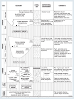
The Simpson Basin contains ?Early to Middle Triassic Walkandi Formation overlain conformably by Late Triassic Peera Peera Formation. Walkandi Formation is restricted to the Poolowanna Trough depocentre. The Peera Peera Formation extends westwards and onlaps the Dalhousie–McDills Ridge and eastwards where it onlaps the Birdsville Track Ridge.
Walkandi Formation consists of interbedded shale, siltstone and minor sandstone redbeds deposited in a shallow ephemeral lacustrine environment. The unit correlates with the Tinchoo Formation of the Cooper Basin to the east. Peera Peera Formation consists of grey shale and siltstone at the base with minor thin sandstone and coal, a fining upward sandy middle unit and a black, silty highly carbonaceous shale at the top — reflecting deposition on a floodplain crossed by meandering fluvial streams with lacustrine development. It is correlated with the Cuddapan Formation of the Cooper Basin region.
The oxidised nature of the Walkandi Formation redbeds downgrades source potential. However, the overlying Peera Peera Formation is rich in organic matter (TOC up to 5%) and should be oil mature in the Poolowanna Trough. The Peera Peera Formation is considered to be gas-prone with modest oil yields.
Limited drilling indicates that sandstone interbeds in the Walkandi Formation are fine grained, with low porosity and permeability. The Peera Peera Formation also suffers from laterally variable, poor quality reservoirs (maximum measured porosity 7.8%). Reservoir quality is thought to improve updip from the Poolowanna Trough.
Seals consist of intraformational siltstone and shale of the Walkandi and Peera Peera formations.
Potential trapping mechanisms are dominantly structural (faulted anticlines).
There is no estimate of undiscovered resources.
The
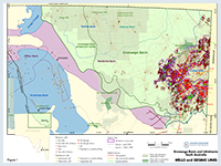
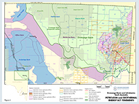
Figure 4 above shows the licence status at the time of publication. For more information on current licences please refer to Holders of Petroleum and Geothermal Tenements in SA information sheet
Cotton TB, Scardigno MF and Hibburt JE eds, 2006. The petroleum geology of South Australia. Vol. 2: Eromanga Basin. 2nd edn. South Australia. Department of Primary Industries and Resources. Petroleum Geology of South Australia Series.
Moore PS, 1986. Jurassic and Triassic stratigraphy and hydrocarbon potential of the Poolowanna Trough (Simpson Desert Region), northern South Australia. In: Gravestock DI Moore PS and Pitt GM eds, Contributions to the geology and hydrocarbon potential of the Eromanga Basin. Geological Society of Australia. Special Publication, 12:39-51.
Powis GD, 1989. Revision of Triassic stratigraphy at the Cooper Basin to Eromanga Basin transition. In: O’Neil BJ ed, The Cooper and Eromanga basins, Australia. Proceedings of the Cooper and Eromanga Basins Conference, Adelaide, 1989. Petroleum Exploration Society of Australia, Society of Petroleum Engineers, Australian Society of Exploration Geophysicists (SA Branches), pp.265-277.
Wiltshire MJ, 1989. Mesozoic stratigraphy and palaeogeography, eastern Australia. In: O’Neil BJ ed, The Cooper and Eromanga basins, Australia. Proceedings of the Cooper and Eromanga Basins Conference, Adelaide, 1989. Petroleum Exploration Society of Australia, Society of Petroleum Engineers, Australian Society of Exploration Geophysicists (SA Branches), pp.279-291.
See additional references in the Peera Peera Formation play analysis.