
The GSSA is responsible for the compilation and publication of geological maps for the whole of the State. Products include regional surface geological maps at various scales, solid geology interpretive maps, thematic maps, remote sensed spectral maps and mineral occurrence maps.
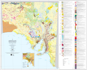 The 1:2 000 000 Geological Map of South Australia (2020) presents the surface geology of the state summarised from sixty-eight 1:250 000 maps. This 2020 edition is the eighth version since its first release in 1899.
The 2M surface geology GIS dataset is regularly updated and is available from SARIG via the 2M Geology map layer (located in the Geology - surface geology layer group).
Geological maps and map data are available as free digital downloads via SARIG either as preset PDF mapsheets or GIS spatial layers.
Available from SARIG via the Mapsheets layer group:
- 1:250 000 Mapsheets (digital surface geology mapsheet and drillhole, and surface/drillhole geochemistry data package)
- 1:100 000 Mapsheets (digital surface geology mapsheet)
Available from SARIG via the Geology layer groups:
- Surface geology at 1:100 000, 1:2 000 000 and 1:7 000 000 scales
- Archean to Ordovician solid geology
- Mineral geological provinces
- Petroleum basins
- Regolith
- Paleodrainage systems
- Field observation sites
Available from SARIG catalogue:
- 1:250 000 scale geological atlas series (many with Explanatory Notes)
- 1:63 360 (one inch to one mile) geological maps (concluded series)
- Special series geological maps at various scales (including 1:50 000 scale maps)
- Metropolitan soils maps
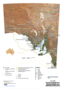 South Australia's major mines and resource projects
Landsat image showing location of:
- major operating and approved mines and producing basins
- mines under care and maintenance
- developing mineral, petroleum and geothermal projects
- gas facilities
- successful gas and oil wells
- geothermal wells
- petroleum pipelines
- ports and proposed ports
Major mines and mineral projects layers are available from SARIG via the South Australia projects layer group.
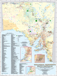
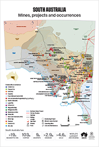 South Australia mines, projects and occurrences
Large format map showing:
- location and operation status of projects
- resource statistics
 South Australian mineral occurrence maps
Surface geology maps showing occurrence type, mineralisation style and economic significance.
Access the South Australian commodity resource, exploration and production dashboard via SARIG.
Map layers are available via SARIG (click All Map Layers and search for commodity).
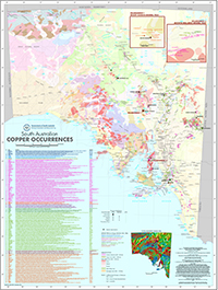
 South Australian Neoproterozoic sediment-hosted copper occurrences
Location map of the 662 copper occurrences identified as being hosted in Neoproterozic sediments. The PDF map is interactive and enables the user to identify occurrences which are hyperlinked to the MINDEP database containing associated information.
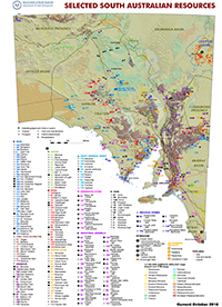 Selected South Australian resources
Surface geology over DTM showing location by commodity of:
- selected South Australian operating and approved mines and quarries
- selected mineral deposits and prospects
- oil and gas fields
- geothermal projects
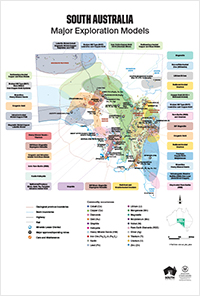 Large format map showing:
- exploration model areas by commodity
- location and operation status of mines
- commodity occurrences
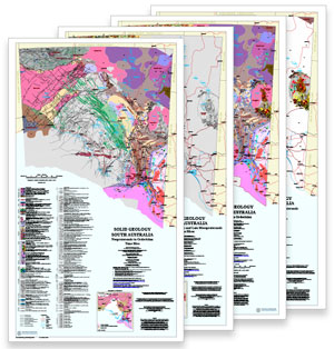 A four-part 1:2 000 000 map series derived from the Solid Geology of South Australia GIS dataset. The maps, each with customised reference, portray:
- Archean to Ordovician Solid Geology, with all time slices superimposed in their actual arrangement
- Archean-Early Mesoproterozoic time slice (Gawler Craton, Curnamona Province)
- Late Mesoproterozoic time slice (Musgrave Province) and Middle Mesoproterozoic (Cariewerloo Basin) time slice combined
- Neoproterozoic-Ordovician time slice (Adelaide Geosyncline, Officer Basin, Warburton Basin, basement to Murray Basin).
The 2M solid geology GIS dataset is regularly updated and is available from SARIG via the Geology - solid geology layer group.
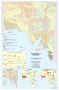 Regolith includes the cover between 'fresh rock and fresh air' and includes fractured and weathered basement rocks, saprolite, soils, organic accumulations, volcanic material, glacial deposits, colluvium, alluvium, evaporitic sediments, aeolian deposits and groundwater.
The 1:2 000 000 regolith map of South Australia consists of three main data components:
- Regolith materials and landforms
- Regolith material induration (ferruginous, calcareous, siliceous, gypsiferous, mixed and undifferentiated)
- Surface lag
The 2M regolith GIS dataset is available from SARIG via the Geology - regolith layer group.
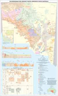 Since first publication in 2007, new data and interpretations arising from regional surveys and exploration activities in South Australia, particularly for uranium, heavy mineral sands and groundwater associated with paleodrainage and coastal sediments, underscored the need for a second edition in 2012.
Updates included revised sediment boundaries based on newly acquired datasets; a modified approach to paleodrainage mapping following industry feedback (e.g. Airborne Electromagnetic (AEM) interpretation workshops); new data from mineral exploration activity (e.g. drilling data); and geological sections illustrating sediment and bedrock relationships.
The 2M Paleodrainage and Cenozoic coastal barriers GIS dataset is available from SARIG via the Geology - palaeodrainage systems layer group.
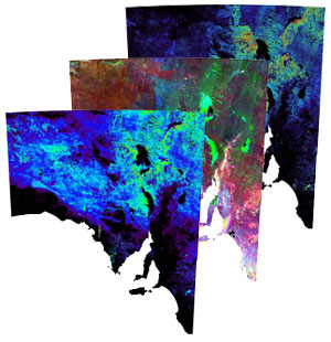 South Australian mineral index maps were generated using remotely sensed multispectral imaging data from the Advanced Spaceborne Thermal Emission and Reflection Radiometer (ASTER).
ASTER’s 14 spectral bands are designed specifically to measure diagnostic absorption bands related to important rock forming mineral groups, which include clays, iron oxides, carbonates, quartz, muscovite and chlorite.
From these bands the CSIRO’s Centre for 3D Mineral Mapping (C3DMM) used a processing methodology that transforms the raw data into visible and near infrared (VNIR)-shortwave and infrared (SWIR), and thermal infrared (TIR) mineral group maps.
ASTER VNIR-SWIR and ASTER TIR state images are available from SARIG via the Remote sensing layer group.
Uncompressed versions of the ASTER regional mineral maps (.tif and .ers formats) are available from Customer Services.
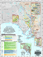
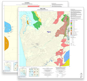 South Australian mineral resource potential mapping translates geological mapping, current productive mineral tenement locations and a range of other resource information into a three-level categorisation of resource potential and suggested planning:
- High mineral potential and/or current operation. Full planning protection required from incompatible development. Key or significant mineral resource areas including current mining operations, most current mineral production tenements, established economically viable mineral resource/reserve or areas with high potential for resource/reserve.
- Medium mineral potential. Mineral potential should be considered in planning. Further consultation or investigation required before incompatible development allowed. Moderate to good geological potential for significant resources known from preliminary geological information.
- Low mineral potential. No specific planning protection required. No or very little known mineral resource potential based on current information.
The mapping process is described in ‘Mineral resource potential mapping – a new mapping product to assist land use planning’, MESA Journal 59:13–15
Current mapping covers the Adelaide and Upper Spencer Gulf regions. Mapping will be undertaken progressively in various other regional growth areas of the state including areas south of Port Augusta and around Whyalla. Maps will be periodically updated as new information becomes available.
Download the map series and the GIS dataset from SARIG via the Geology - mineral resource potential layer group.
 This 1:2 000 000 map shows the location and extent of the 433 geological sites so far assessed by the Geological Society of Australia (GSA) to be of special importance in South Australia.
A list of the site names in order of GSA reference number (the key identifier) is provided. The background is a version of the 1:2 000 000 Geological Map of South Australia. Depiction of Local Government areas on the map also allows the user to identify the council responsible for local administrative and planning issues involving geological monuments.
The GIS dataset is available from SARIG via the Geological Monuments map layer (located in the Geology layer group).