
Summary
| PLAY | Casterton Formation |
| BASIN | Otway |
| LOCATION | Onshore Otway Basin, South Australia |
| AGE | Late Jurassic |
| RESERVOIR | Casterton Formation sandstone |
| SEAL | Lower Sawpit Shale shales Northeast: Sawpit Sandstone shales & siltstones |
| SOURCE ROCK/S | Casterton Formation |
| HYDROCARBON PHASE | Gas & Oil |
| PRODUCTION | None |
| HYDROCARBON FLOW RATES | None – Gas shows but no DSTs |
| POTENTIAL RESOURCES | None estimated |
Location maps
Geological Setting maps
The Casterton Formation play exists in the onshore Otway Basin in South Australia:
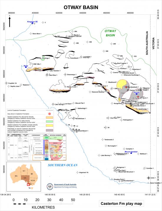
Download play extent map of the Casterton Formation (JPG 5.3 MB)
The Casterton Formation represents the first sedimentation on top of the Basement in the onshore Otway Basin.
Boult et al (2002) described the Casterton Formation as “a pre-rift or early syn-rift deposit, with strong structural controls on deposition and contemporaneous volcanism. The unit consists of medium to dark brown and dark grey, silty carbonaceous mudstone. … In South Australia, a lacustrine environment of deposition, distant from volcanic vents (presumably located in Vic.) is inferred for the unit.”
There is no discussion of the Casterton Formation being a potential reservoir in Morton et al (2002). However, the upper and lower boundaries of the Casterton Formation are unconformities according to Boult et al (2002), possibly angular on seismic evidence, and consequently on this basis it is likely that there has been reworking of the Basement into the Casterton Formation. The DEM review of the stratigraphy, description of core data and seismic mapping in the onshore Otway Basin in 2022/23 resulted in the reinterpretation of Basement in a number of wells as having been reworked during the latest Jurassic as part of the Casterton. In particular, Jolly 1 ST1 and Bungaloo 1, both drilled in 2014, encountered what have been interpreted by DEM to be turbidite sands within the Casterton Formation, deposited in the deep lake in the Penola Trough.
There were gas shows in the Casterton Formation in Bungaloo 1 and Jolly 1 ST1 but there has been no production from the formation in the onshore Otway Basin.
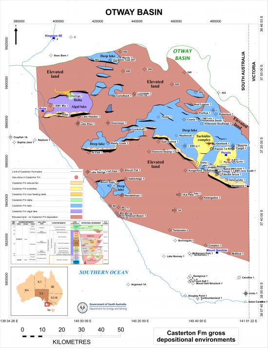
Gross depositional environments of the Casterton Formation in the onshore Otway Basin (JPG 5.6 MB)
The seal to Casterton Formation sandstone reservoirs over most of the onshore Otway Basin in South Australia is the lacustrine Lower Sawpit Shale directly above, in particular the basal shale. The whole section is likely to provide suitable seal even where the McEachern turbidites are present and the interval thins to the north-east, except for any alluvial fans that may be present.
Over the north-east where the Lower Sawpit Shale pinches out seal would be provided by floodplain shales and silts of the Sawpit Sandstone, except where narrow river systems occur.
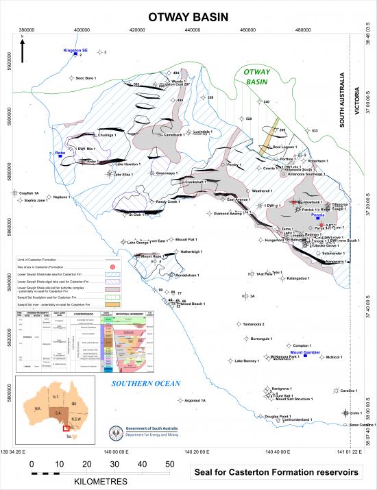
Extent of seals for Casterton Formation reservoirs (JPG 6.2 MB)
There are several intervals in the onshore Otway Basin that contain suitable material to have acted as potential source rocks for charge of hydrocarbons into the Pretty Hill Sandstone reservoir:
- the Early Cretaceous Eumeralla Formation
- the Early Cretaceous Laira Formation of the Crayfish Subgroup
- the Early Cretaceous Upper Sawpit Shale of the Crayfish Subgroup
- the Early Cretaceous Lower Sawpit Shale of the Crayfish Subgroup, and
- the Late Jurassic Casterton Formation.
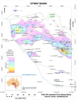
Basin modelling in the onshore Otway Basin conducted by DEM (2023 DEM Petroleum Systems Study) suggests that both gas and oil have been expelled from major source rocks in the onshore Otway Basin.
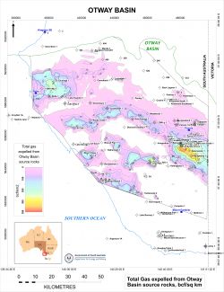
Download total gas expelled from Otway Basin source rocks map (JPG 5.9 MB)
Download total oil expelled from Otway Basin source rocks map (JPG 5.5 MB)
1. Eumeralla Formation
Basin modelling in the onshore Otway Basin suggests that the Eumeralla Formation has not been mature for generation and expulsion of hydrocarbons in the onshore Otway Basin.
2. Laira Formation
The Laira Formation has been recognised as a potential source interval for hydrocarbons in the onshore Otway Basin since the 1990s, containing algal-rich zones with high TOC deposited in lacustrine conditions (Hill and Boult, 2002). Hydrocarbon Index (HI) values indicate that the Laira Formation is predominantly Type IV grading to at best Type III kerogen so is mainly gas-prone.
Basin modelling in the onshore Otway Basin conducted by DEM in 2023 suggests that the Laira Formation has only ever been mature for generation and expulsion of gas in the deepest parts of the Penola Trough and Tantanoola Trough, where it is over 1000m thick; maturity of this source rock interval has not previously been identified in the Tantanoola Trough. However, the Laira Formation sits stratigraphically above the Casterton Formation, and so it is unlikely that the latter has been charged by gas generated from the Laira Formation.
See the Laira Formation play for a map of the modelled gas expelled from the base of the Laira Formation.
3. Upper Sawpit Shale
The Upper Sawpit Shale is the interval referred to as the “Intra-Pretty Hill Formation (Sawpit) shales” by Hill and Boult (2002), with the source rock interval representing lacustrine deposits over 200m in thickness in the Penola Trough and over 100m in the Robe Trough. Source richness of this interval is fairly uniform and constitutes a good source rock (mean TOC = 1.22%). Source quality is marginal to moderate, with little variation in kerogen type and source potential between the unnamed basal shale and intra-Pretty Hill shale.
The DEM basin modelling indicates that significant amounts of gas may have been generated from the Upper Sawpit Shale in the deepest portions of the Penola Trough close to the border between South Australia and Victoria, although the interval appears to have been mature for gas generation in the rest of the Penola Trough and in the St Clair Trough, the Rivoli Trough and the Robe Trough.
See the Upper Sawpit Shale play for a map of the modelled gas expelled from the Upper Sawpit Shale.
4. Lower Sawpit Shale
The Lower Sawpit Shale interval is of significant thickness in the onshore Otway Basin, being over 3000m thick in the deepest parts of the Penola Trough, and over 1500m thick in the Robe and St Clair Troughs, according to seismic mapping. It consists of two separate intervals deposited in deep lacustrine deposits, some of it interpreted to have been deposited in algal lakes. The basal shale interval is equivalent to the McEachern Sandstone turbidites, and is referred to by Hill and Boult (2002) as the “unnamed basal shale”, the major source rock of the Pretty Hill Formation.
The basin modelling conducted by DEM indicates that the most mature area for generation of hydrocarbons from the Lower Sawpit Shale is the deepest portions of the Penola Trough, with significant amounts of both gas and oil generated. The interval also appears to have been mature for gas generation in most of the rest of where the interval occurs, with potentially large amounts of gas and oil having been generated in the deeper areas of the Robe Trough, the St Clair Trough and the Rivoli Trough.
See the Lower Sawpit Shale play for a map of the modelled gas expelled from the Lower Sawpit Shale.
5. Casterton Formation
The Casterton Formation represents the richest source rock of the Otway Supergroup, although it has only been sparsely intersected. Seismic mapping suggests that it may be over 1000m in places. It comprises pre-rift to early syn-rift interbedded shales, siltstones and sandstones and volcanic lithologies, such of which were reworked from the Basement, deposited under lacustrine conditions, very deep in some places. The richest source rocks contain algal material.
The results of the DEM basin modelling show that the Casterton Formation is mature for generation of gas and oil over just about the whole of the areas where it is present, the exception being in the very north of the Otway Basin.
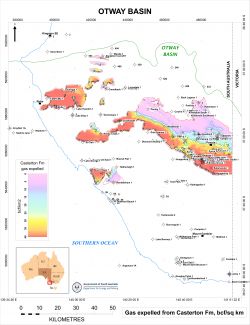

Modelled gas expelled from the Casterton Formation in the onshore Otway Basin (JPG 5.3 MB)
Modelled oil expelled from the Casterton Formation in the onshore Otway Basin (JPG 5.4 MB)
Charge for the Casterton Formation
Potential reservoirs within the Casterton Formation are likely to have been charged with gas and/or oil expelled only from source rocks in the Casterton Formation, as the other source rocks in the onshore Otway Basin all sit stratigraphically above the reservoir section, although there may be occurrences where mature Lower Sawpit Shale source rocks in the footwall of major faults may have charged Casterton reservoirs in the hanging wall.
Extents of modelled gas and oil expelled from Casterton Formation source rocks that may have charged Casterton Formation reservoirs:
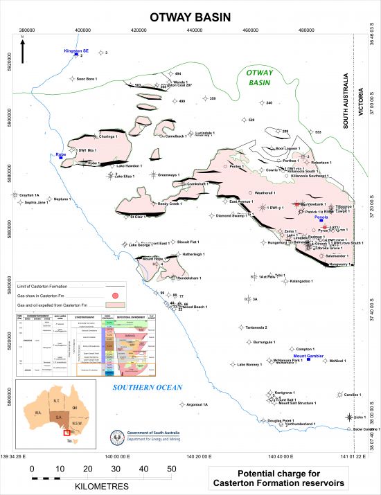
Download potential charge for Casterton Formation map (JPG 5.3 MB)
Data from PEPS South Australia:
| Proven production from the Upper Sawpit Shale: | None |
| Number of producing wells at 31 March 2024: | None |
| Total production at 31 March 2024: | None |
| Hydrocarbon flow rates: | None – Gas shows but no DSTs |
No estimate has been made to date.
Boult, PJ, White, MR, Pollock, R, Morton, JGG, Alexander, EM and Hill, AJ, 2002. Lithostratigraphy and environments of deposition. Chapter 6, Boult, PJ and Hibburt, JE, eds: The Petroleum Geology of South Australia. Volume 1, Second Edition: Otway Basin, South Australia. Department of Primary Industries and Resources. Petroleum Geology of South Australia Series.
Hill, A and Boult, PJ, 2002. Source rock distribution. Chapter 8, Boult, PJ and Hibburt, JE, eds: The Petroleum Geology of South Australia. Volume 1, Second Edition: Otway Basin, South Australia. Department of Primary Industries and Resources. Petroleum Geology of South Australia Series.
Morton, JGG and Boult, PJ, 2002. Undiscovered petroleum resources. Chapter 13, Boult, PJ and Hibburt, JE, eds: The Petroleum Geology of South Australia. Volume 1, Second Edition: Otway Basin, South Australia. Department of Primary Industries and Resources. Petroleum Geology of South Australia Series.
Morton, JGG, Sansome, A and Boult, PJ, 2002. Reservoirs and seals. Chapter 10, Boult, PJ and Hibburt, JE, eds: The Petroleum Geology of South Australia. Volume 1, Second Edition: Otway Basin, South Australia. Department of Primary Industries and Resources. Petroleum Geology of South Australia Series.