
Summary
| PLAY | Purni Formation |
| SOUTH AUSTRALIA BASIN | Pedirka |
| LOCATION | Pedirka Basin, including Eringa Trough |
| AGE | Early Permian in SA; Early to Middle Permian (and possibly late Permian) in NT |
| RESERVOIR | Purni Fm. intraformational sandstones |
| SEAL | Purni Fm. intraformational shales and coals; Walkandi Fm/Peera Peera Fm topseal in central and eastern side of basin |
| SOURCE ROCK/S | Purni Fm. coals; Possibly Peera Peera Fm., Lower Poolowanna Fm. |
| HYDROCARBON PHASE | Gas/very light oil |
| PRODUCTION | None; no hydrocarbon shows to date other than gas shows from coals |
| HYDROCARBON FLOW RATES | Calculated water flow rate of 869BPD in Macumba 1 |
| POTENTIAL VOLUMES | There is no estimate of undiscovered resources |
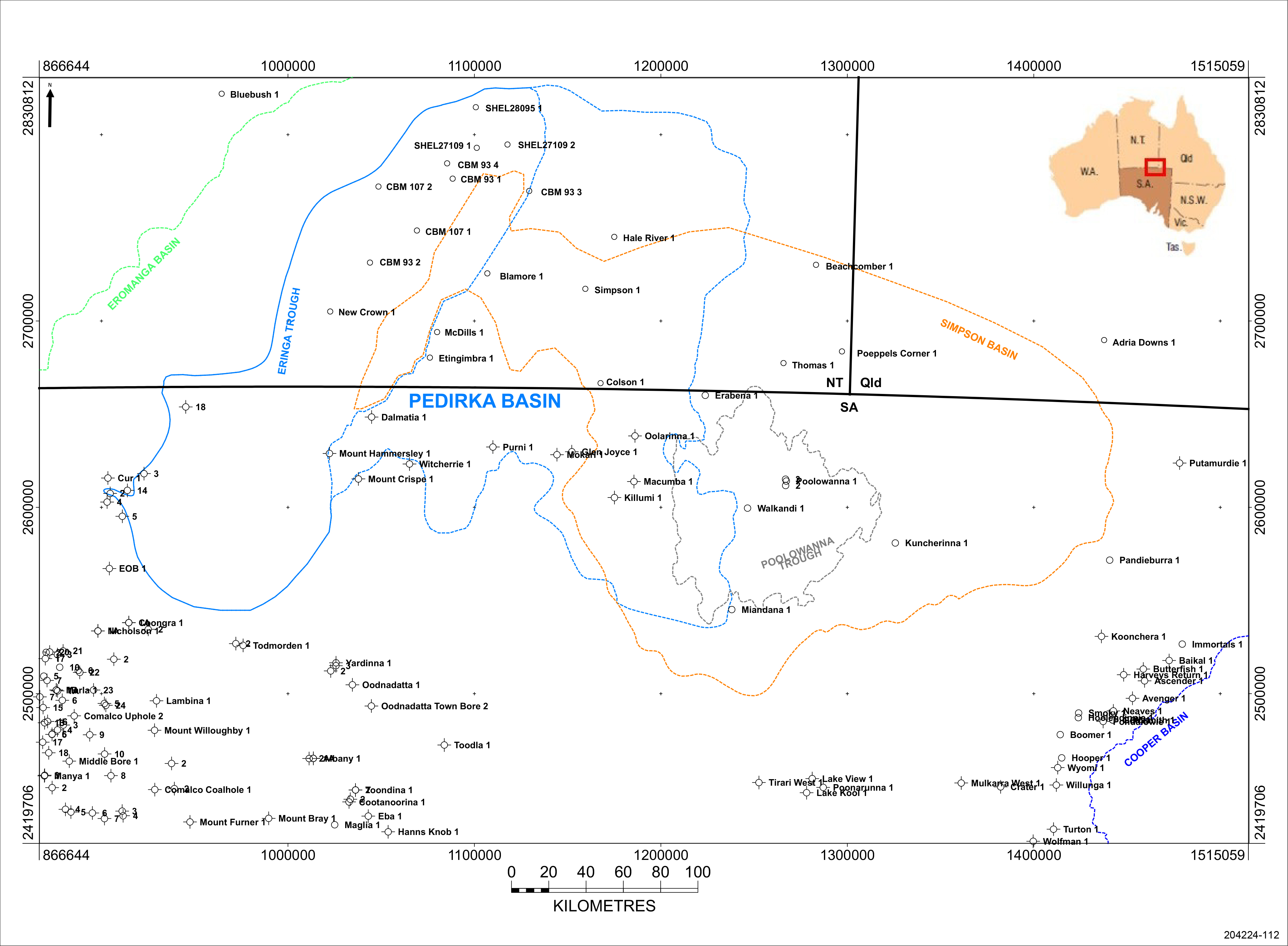
Location of the Pedirka Basin in central Australia
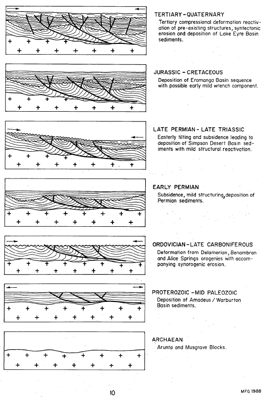
The Pedirka Basin has an area of around 60,000 km2, just under half of which is in South Australia and the remainder in the Northern Territory. It is an intracratonic basin unconformably overlying the SE Amadeus Basin and western Warburton Basin which were deformed during the Alice Springs Orogeny and possibly the Delamerian Orogeny.
A final NW–SE compressional phase of the Alice Springs Orogeny in the Mid to Late Carboniferous initiated deposition in the Pedirka Basin and created thrust faults such as occur at Mt Hammersley 1. Permo-Carboniferous sediments were subsequently deposited in a tectonically quiescent sag phase. In South Australia the Permian is entirely overlain by up to 2500m of Triassic to Late Cretaceous sediments of the Simpson and Eromanga basins.
The Purni Formation was deposited in an extensive coal swamp and floodplain environment crossed by high-sinuosity fluvial channels. The lower boundary of the Purni Formation is a disconformity with the Crown Point Formation over much of the Pedirka Basin, however, in Mt Hammersley 1 the Purni Formation disconformably overlies Mt Toondina Formation equivalent (Alexander et al, 2007), the only place in the Pedirka Basin where this occurs. The upper boundary is the unconformity with Triassic sediments of the Simpson Basin or Jurassic–Cretaceous sediments of the Eromanga Basin.
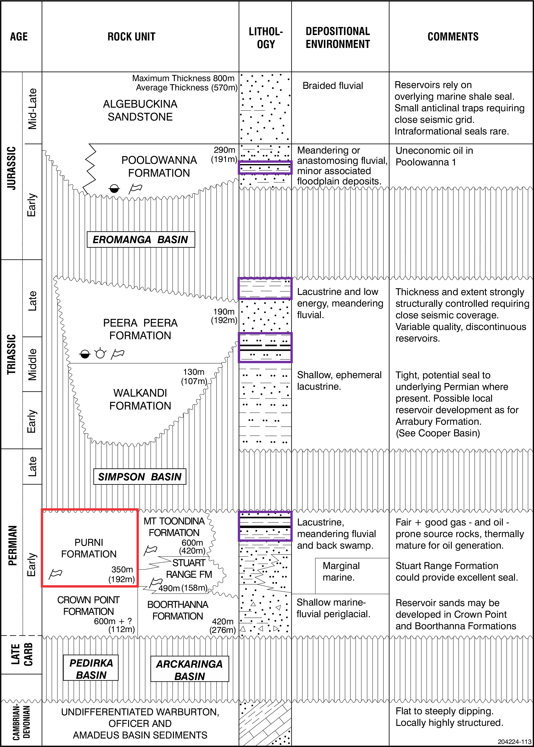
Geological summary of the Arckaringa, Pedirka and Simpson basins. Purni Formation highlighted in red. Potential source rocks highlighted in purple.
Youngs (1975) formally defined three facies suites in the type section in Purni 1 (drilled in 1963/4) on the basis of relative proportions of sandstone, shale and coal:
- The upper member consists of fine-grained, silty cross-bedded sandstone and carbonaceous shale interbeds with abundant coal seams
- The middle member is characterised by upward-fining cross-bedded sandstone with interbeds of grey carbonaceous siltstone and shale with minor coal
- The basal member consists of thinly interbedded grey shale and fine to medium-grained sandstone, with minor conglomerate and coal stringers
This subdivision is slightly different in Northern Territory, where “four informal stratigraphic units (A1, A, B and C) are recognised, based on drillhole and seismic data” (Munson, 2014); the intervals are described in detail in Ambrose and Heugh (2012) based on facies description, palynology, and coal seam correlation:
- Unit C – uppermost unit
- contains a sequence of interbedded coal and clastic sedimentary rock that are bound at the top and base by unconformities
- likely to occur only in the deepest portions of the Eringa Trough, and is unlikely to be present in South Australia
- Unit B – overlies Unit A, probably disconformably
- consists of interbedded siltstone, sandstone and coal
- the uppermost interval is likely to occur only in the deepest portions of the Eringa Trough, and is unlikely to be present in South Australia
- probably equivalent in part to the upper member of Youngs (1975)
- Unit A – conformably overlies Unit A1
- consists of thick coal seams and interbedded clastics
- probably equivalent to the middle member of Youngs (1975)
- Unit A1 - the basal unit
- consists of sandstone interbedded with siltstone and finer sandstone. Coal seams are thin, but the presence of higher carbonaceous content is used to discriminate between the Purni Formation and underlying glacial sequences
- probably equivalent to the basal member of Youngs (1975)
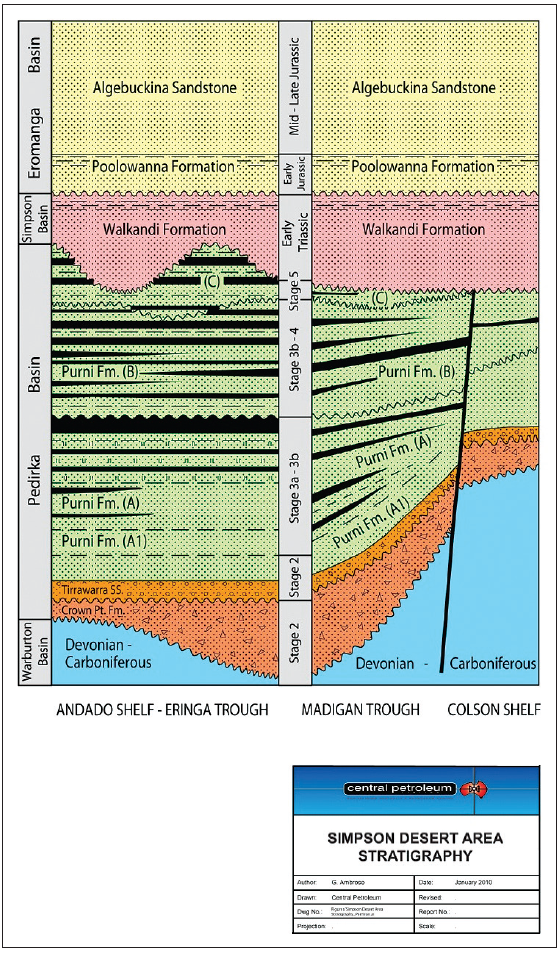
Purni Formation stratigraphy in Northern Territory (Ambrose and Heugh, 2012)
NNE-striking high-angle reverse faults separate NNW to NNE-trending anticlinal complexes. The most prominent is the Dalhousie–McDills Ridge separating the Pedirka Basin into a western and eastern portion. Permo-Carboniferous sediments are preserved across the ridge linking the two depocentres. The thickest sediments estimated from seismic interpretation (over 660m) are preserved in the Eringa Trough. In South Australia Mt Hammersley 1, drilled in 1987 on the eastern flank of the trough, intersected 281m of Purni Formation, with a maximum thickness on the eastern side of the Pedirka Basin of 350m at Mokari 1.
The thickest Purni interval encountered to date is in Blamore 1 drilled between the Eringa and Madigan Troughs in Northern Territory with 601m, although at least 593m of Purni was drilled in CBM 93-01 in the Eringa Trough, so the section may be thicker than in Blamore 1. Much of this thickness is due to the presence of the younger Purni Units B & C than the section in the eastern side of the basin (Ambrose and Heugh, 2012), and contains much more coal, with a total 153m of coal in seams greater than 0.2m, also assessed as a total of 138m of coal in seams greater than 2.0m thickness, similar to that in Blamore 1, “with both wells intersecting significantly more coal than any other wells in the Pedirka Basin and both intersecting a single coal seam in the lower sequence of coals approaching 40 m. in thickness” (CBM 93-01 Well Completion Report).
The sediments were subsequently uplifted and eroded during two major compressional episodes during the Early to Late Permian and during the Tertiary.
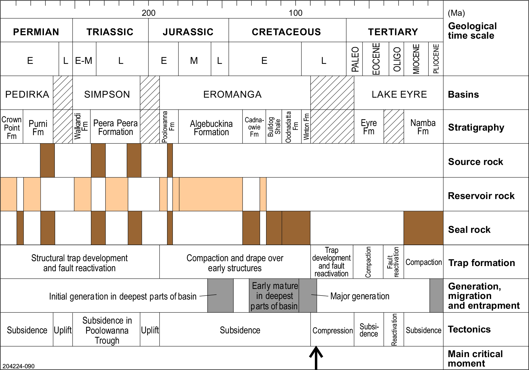
Key petroleum system events in the Pedirka Basin/Simpson Basin/Poolowanna Trough area
The key petroleum events chart for the Pedirka Basin/Simpson Basin/Poolowanna Trough region is similar to that for the Cooper-Eromanga Basins in that the critical moment was in the Late Cretaceous at the end of deposition of the Winton Formation, the last stage of the Eromanga Basin prior to uplift and erosion. Basin modelling suggests that major hydrocarbon generation and expulsion commenced around 100Ma (Ambrose et al, 2007) and lasted around 10-15Ma, so formation of structures prior to this was critical.
Structural reactivation occurred in the Miocene, and it is likely that this breached seals for some hydrocarbon accumulations where fault seal was critical, such as Poolowanna 1. Therefore, exploration is required of more subtle structures not affected by the reactivation in the Miocene.
Schematic structural history of the Pedirka Basin-Poolowanna Trough area (Giuliano, 1988)
Petroleum exploration commenced in the 1950s when licences covering the Cooper and Eromanga basins were first acquired by Santos, who went against conventional wisdom that commercial accumulations of oil would not be found in Mesozoic formations within the Great Artesian Basin.
Initial exploration involved surface mapping, stratigraphic drilling, aerial surveys, gravity and aeromagnetic surveys and seismic. The first petroleum well was drilled in 1959 and Cooper Basin gas was discovered in 1963.
The first commercial hydrocarbon to flow from the Eromanga Basin was gas produced from Namur 1 in 1976 (Cooper region). Oil was discovered in 1977 with uneconomic flows of oil from basal Jurassic and Triassic sediments in Poolowanna 1 in the Poolowanna Trough. The first economic oil flow was recorded from Strzelecki 3 (Cooper region) in the following year and this stimulated a major oil exploration program.
Exploration activity intensified in the Poolowanna Trough/Pedirka Basin area in the 1980s in response to the Poolowanna discovery. Six seismic surveys were carried out and five wells were drilled, three in 1985 and two in 1988.
Seismic reinterpretation by Santos indicated that five of the previously drilled wells were not valid structural tests being outside closure at all objectives. Of the 1985 wells, Oolarinna 1 had no independent fault closure and Glen Joyce 1 had little closure.
It should be noted that no wells have been drilled in the South Australian sector since the 1980s, and exploration in the area would benefit from current ideas on the geology of the petroleum systems in the Cooper Basin region and modern technology and interpretation techniques. Several wells have been drilled in Northern Territory in recent times:
- Central Petroleum drilled exploration wells Blamore 1, CBM 93-01 and Simpson 1 in 2008;
- Central Petroleum drilled CBM 107 01, CBM107 02, CBM93 02, CBM93 03 and CBM93 04 in 2009/10 to investigate coal potential in the Purni Formation;
- Merlin Coal drilled SHEL2710-2, SHEL27109-1 and SHEL28095-1 in 2010/11 under a minerals licence for coal; and
- Tri-Star Energy drilled exploration well New Crown 1 in 2014.
Hydrocarbon shows have been recorded in most wells within the Pedirka Basin region. However, oil and gas has been recovered from only 2 wells, the Poolowanna and Peera Peera Formations in Poolowanna 1, and the Poolowanna Formation in Poolowanna 3.
The classification scheme used by Geoscience Australia has been used to determine the type of show present in a formation in the tables below.
Hydrocarbon shows and flow rates in South Australian wells in the Poolowanna Trough/Simpson Basin/Pedirka Basin region:
| Well | Year/Result | Formation | Shows/Recovery | Flow rate |
|---|---|---|---|---|
| Pandieburra 1 |
1963 Oil shows | Peera Peera (?) | Minor fluorescence | |
| Dullingari Group | Minor fluorescence. Recovered 190ft mud-cut water with a trace of hydrocarbons. | |||
| Mokari 1 |
1966 Dry hole | Poolowanna | Gas show; mudlog gas 14 times background. Minor fluorescence. Water to surface (WTS) in 12 mins. | 387 cu ft/hr = rate of 1,654BWPD |
| Purni | Minor fluorescence. WTS in 17 mins. | Reported rate of 387 cu ft/hr | ||
| Poolowanna 1 |
1977 Oil shows | Poolowanna | Gas to surface (GTS) in 125 mins. Oil and water to surface in 3hrs 55 mins. Recovered 71¼ barrels water and 9½ barrels oil, 36.9o API gravity, with pour point of 41o C. | Gas at rate too small to measure (RTSTM). Calculated flow rate of 96BOPD |
| Peera Peera | Oil show. GTS in 120mins. Recovered 110ft mud and condensate. | Gas at RTSTM | ||
| Walkandi 1 |
1981 Oil shows | Poolowanna | Oil shows. Recovered 650ft muddy water and 1450ft gas-cut slightly muddy water. | |
| Peera Peera | Oil shows. Recovered 46ft rat hole mud and 31ft slightly gas-cut mud. | |||
| Walkandi | Oil shows. Recovered 480ft water cushion and 4900ft slightly gas-cut mud. | |||
| Erabena 1 |
1981 Oil shows | Poolowanna | Minor fluorescence | |
| Peera Peera | Minor fluorescence | |||
| Kuncherinna 1 |
1981/2 Oil shows | Poolowanna | Recovered 90ft rathole mud with trace of oil | |
| Peera Peera | Minor fluorescence | |||
| Poolowanna 2 |
1985 Oil shows | Wallumbilla | Minor fluorescence | |
| Cadna-owie | Minor fluorescence | |||
| Algebuckina | Minor fluorescence | |||
| Poolowanna | Minor fluorescence. Recovered 1026ft VSGCMW, 306ft SGCM. | |||
| Peera Peera | Minor fluorescence. Recovered 240ft very slightly gas-cut muddy water. | |||
| Oolarinna 1 |
1985 Dry hole | Poolowanna | Minor fluorescence | |
| Peera Peera | Recovered 5310ft gas-cut water (slightly muddy at top) | |||
| Killumi 1 |
1985 Dry hole | Poolowanna | Minor fluorescence | |
| Miandana 1 |
1985 Oil shows | Poolowanna | Minor fluorescence | |
| Poolowanna 3 |
1989 Oil shows | Algebuckina | Minor fluorescence | |
| Poolowanna | Minor fluorescence. GTS in 141 mins. Recovered 5550ft slightly oil and gas-cut water and 2290ft water in 171 mins. | Gas at RTSTM. 80BWPD. | ||
| Peera Peera | Minor fluorescence |
Hydrocarbon shows in Northern Territory wells in the Poolowanna Trough/Simpson Basin/Pedirka Basin region:
| Well | Year/Result | Formation | Shows/Recovery |
|---|---|---|---|
| McDills 1 | 1965 Trace hydrocarbon indication | Purni | Minor fluorescence |
| Colson 1 | 1978 Trace hydrocarbon indication | Poolowanna | Minor fluorescence |
| Peera Peera | Minor fluorescence | ||
| Warburton | Log interpretation “oil show” | ||
| Thomas 1 | 1981 Oil indication | Poolowanna | Residual oil. Recovered 4951ft water with minor mud in 68 mins. |
| Poeppels Corner 1 | 1984 Trace hydrocarbon indication | Algebuckina | Minor fluorescence |
| Poolowanna | Minor fluorescence | ||
| Peera Peera | Minor fluorescence | ||
| Beachcomber 1 | 1988 Trace hydrocarbon indication | Cadna-owie | Minor fluorescence in coals |
| Algebuckina | Minor fluorescence in coals | ||
| Peera Peera | Minor fluorescence in coals | ||
| Blamore 1 | 2008 Oil and gas show | Algebuckina | Residual oil |
| Walkandi | Minor fluorescence | ||
| Purni | Gas shows in coals. Trace fluorescence. | ||
| CBM 93 1 | 2008 Trace hydrocarbon indication | Purni | Minor fluorescence |
| Simpson 1 | 2008 Trace hydrocarbon indication | Poolowanna | Minor fluorescence |
| Walkandi | Minor fluorescence |
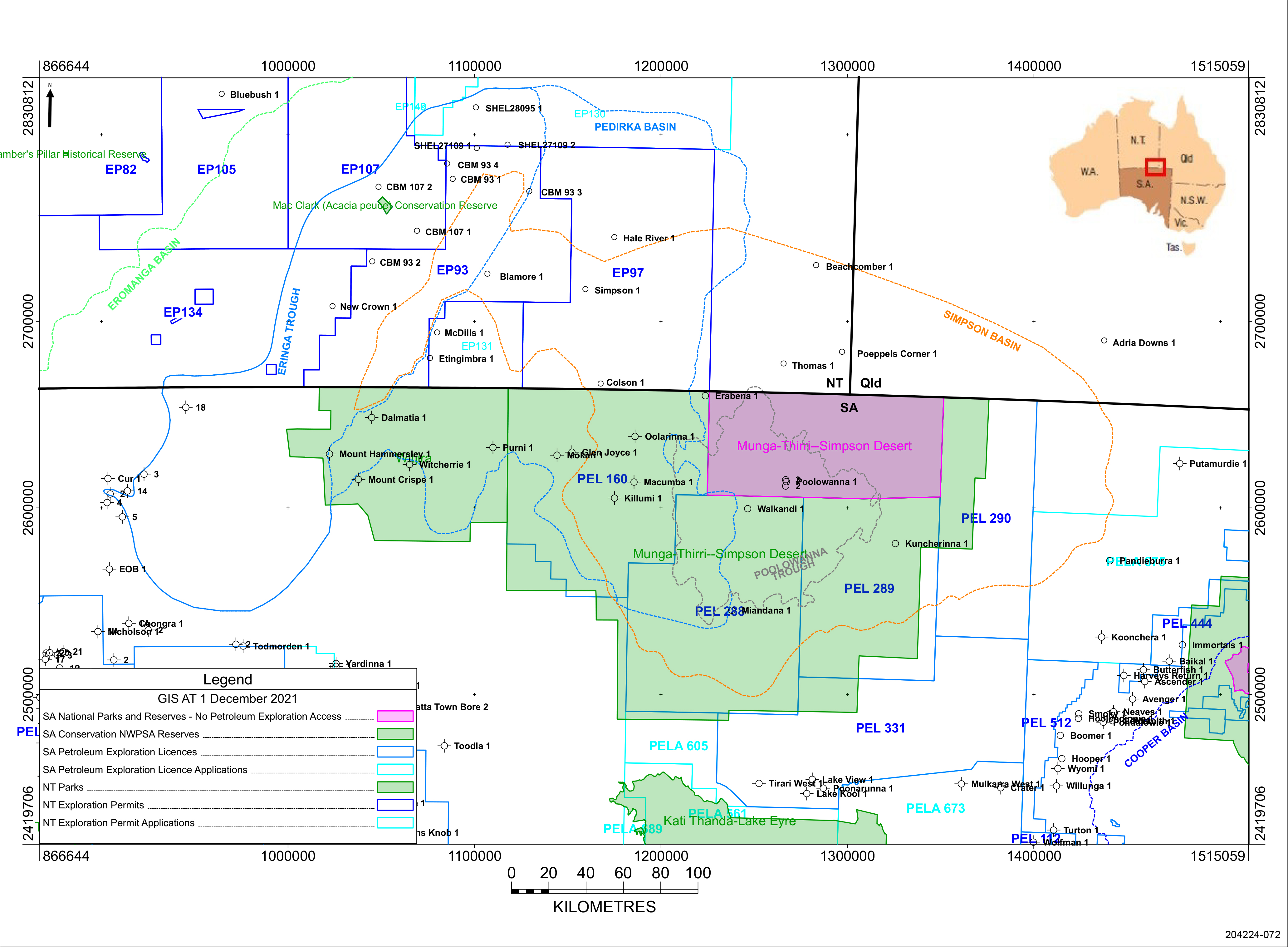
Petroleum exploration permits, regional reserves and conservation parks in the Pedirka Basin area as at December 2021
The Purni Formation play occurs within the Pedirka Basin, although the play has not been proven as there have been no hydrocarbon shows to date other than gas shows from coals.
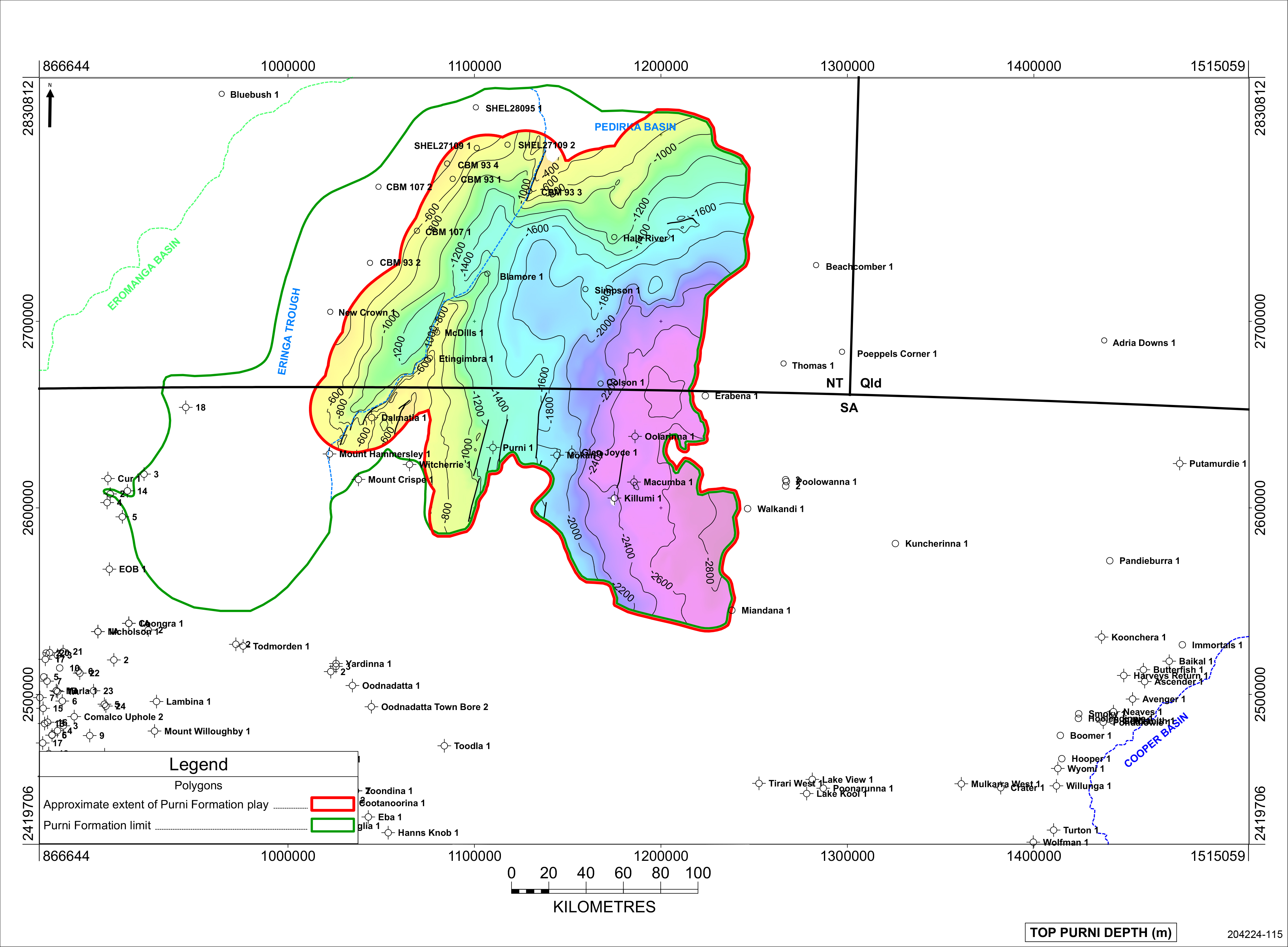
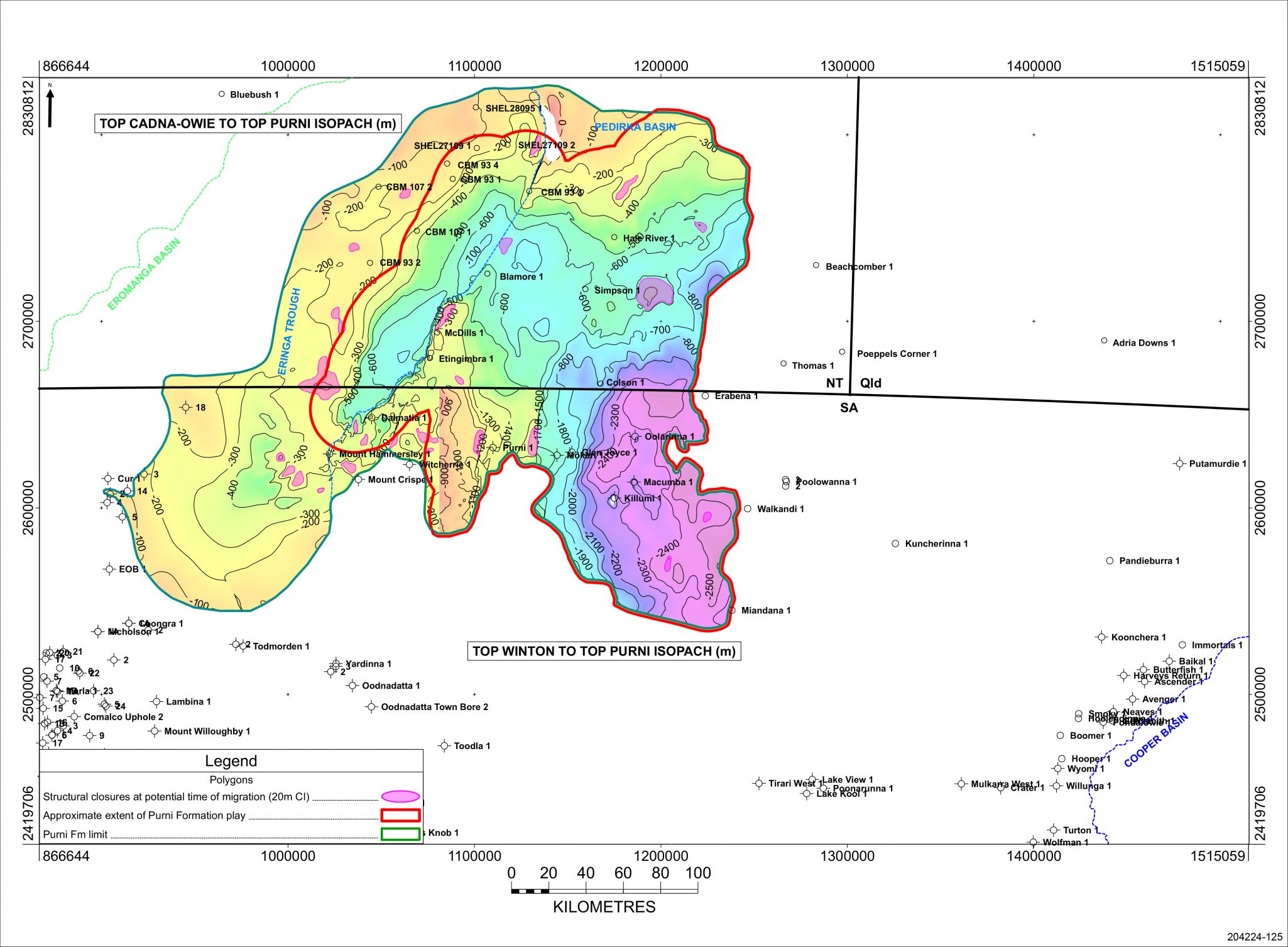
Approximate extent of the Purni Formation play in the Pedirka Basin
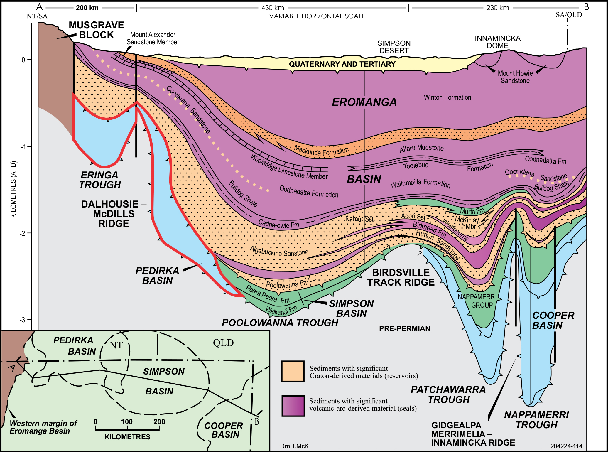
Schematic section across the Eromanga, Pedirka and Simpson basins. Pedirka Basin highlighted in red.
Purni 1 (1963/4)
The Purni Formation in Purni 1 is the type section for the formation in the South Australian sector of the Pedirka Basin.
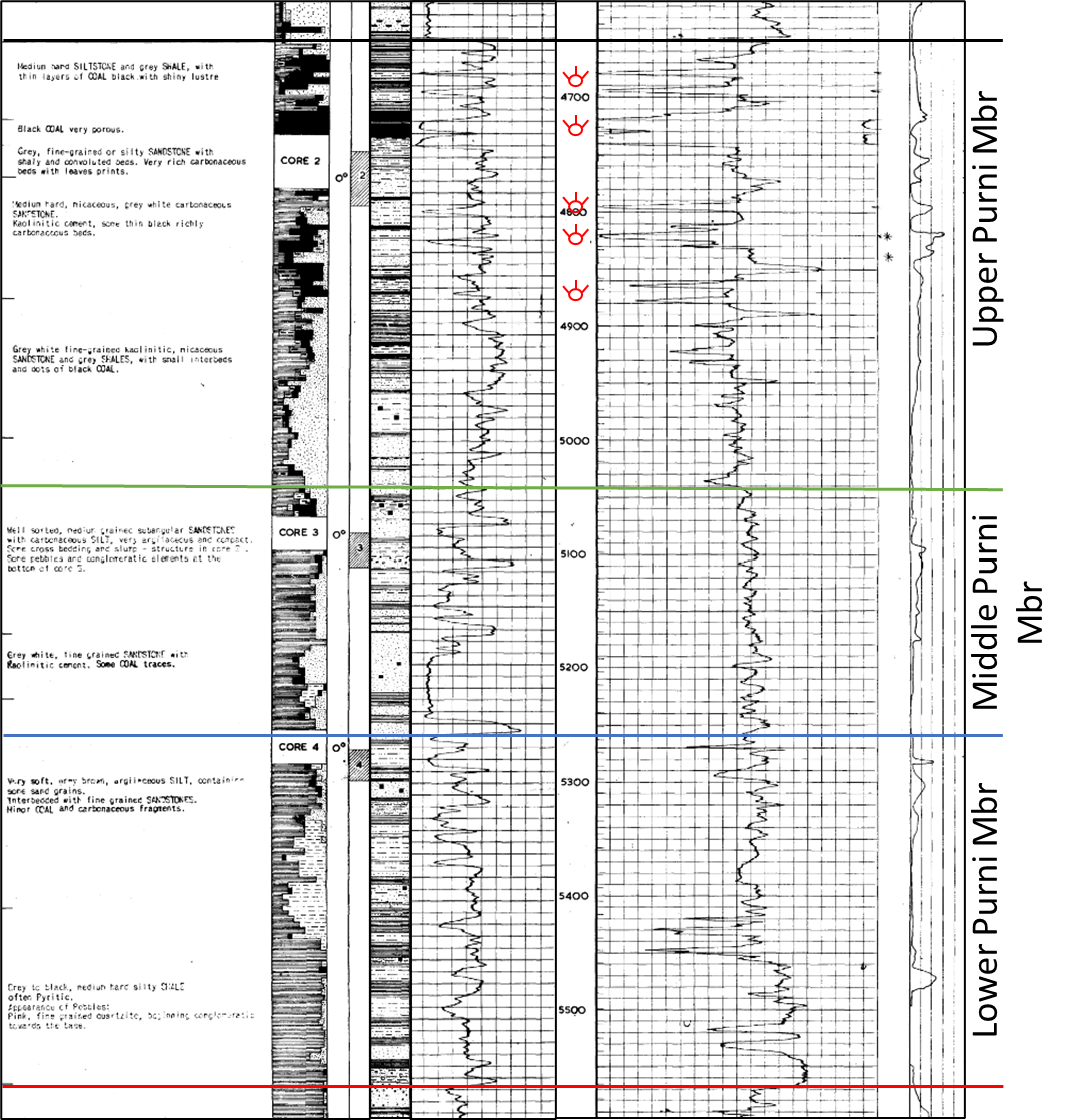
Purni Formation in type well Purni 1 with subdivisions from Youngs (1975) (excerpt from Composite Log)
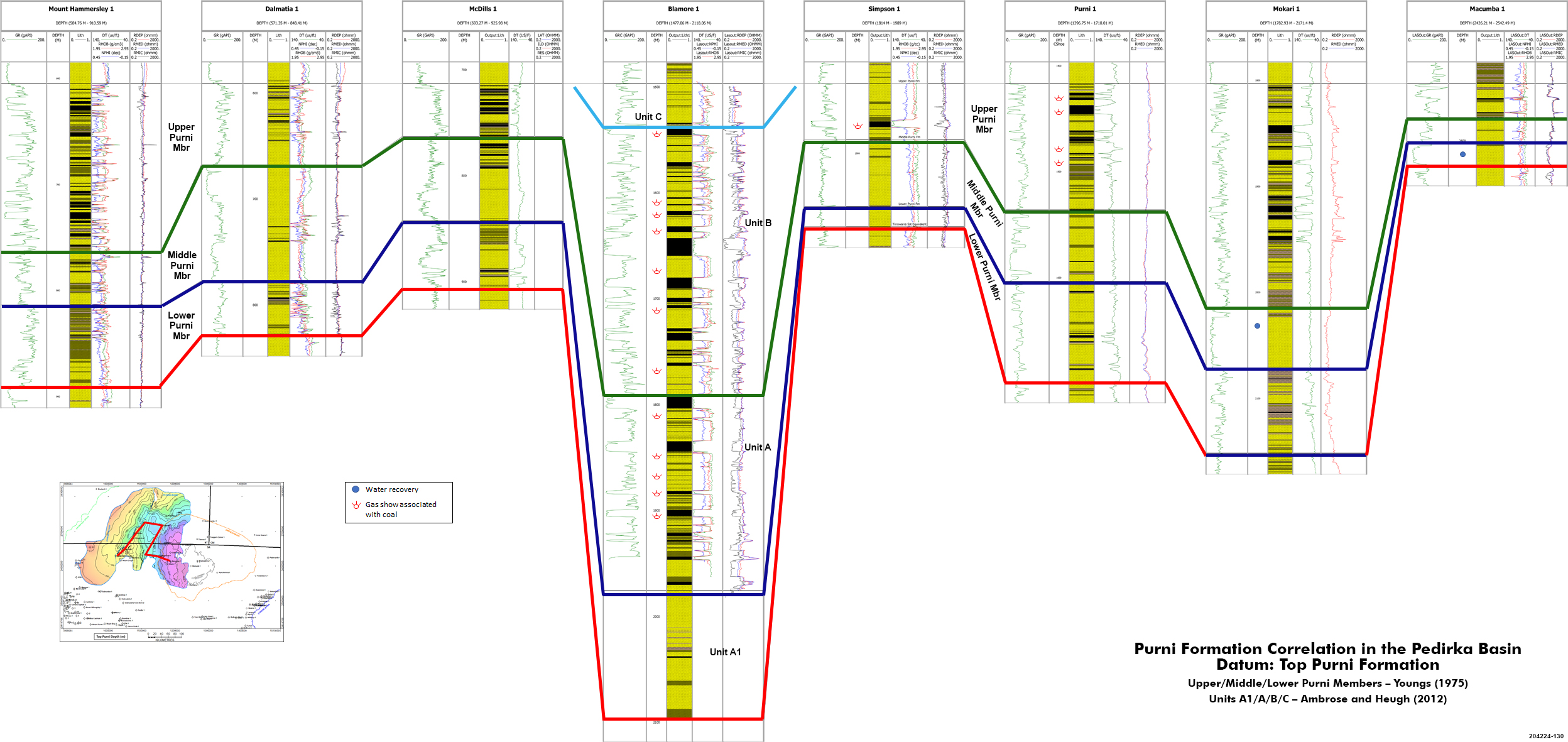
Purni Formation correlation in the Pedirka Basin. Datum: Top Purni Formation (JPG 1.1 MB)
Upper/Middle/Lower Purni Members – Youngs (1975)
Units A1/A/B/C – Ambrose and Heugh (2012)
Analogue: Patchawarra Formation in the Cooper Basin
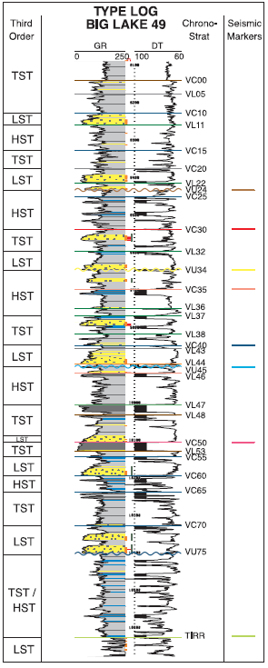
Patchawarra Formation type log (Strong et al, 2002)
The Purni Formation was deposited in an extensive coal swamp and floodplain environment crossed by high-sinuosity fluvial channels. The lower boundary of the Purni Formation is a disconformity with the Crown Point Formation over much of the Pedirka Basin, however, in Mt Hammersley 1 Purni Formation disconformably overlies Mt Toondina Formation equivalent (Alexander et al, 2007) the only place in the Pedirka Basin where this occurs. The upper boundary is the unconformity with Triassic sediments of the Simpson Basin or Jurassic–Cretaceous sediments of the Eromanga Basin.
Youngs (1975) formally defined three facies suites in the type section in Purni 1 on the basis of relative proportions of sandstone, shale and coal:
- The upper member consists of fine-grained, silty cross-bedded sandstone and carbonaceous shale interbeds with abundant coal seams
- The middle member is characterised by upward-fining cross-bedded sandstone with interbeds of grey carbonaceous siltstone and shale with minor coal
- The basal member consists of thinly interbedded grey shale and fine to medium-grained sandstone, with minor conglomerate and coal stringers
The middle member is likely to exhibit the best reservoir quality, but potentially good reservoirs occur throughout the formation.
Table 1: Purni Formation porosity and permeability values extracted from well completion reports (Wohling et al, 2013)
| Well Name | Reference | Porosity (%) | Permeability (mD) | Derived Hydraulic Conductivity (m/d)* |
|---|---|---|---|---|
| Etingimbra | Osborne and Edwards (1990) | 31–32 | ||
| Colson | Beach Petroleum (1979) | 13–16 | ||
| Hale River No 1 | Amerada Petroleum (1966) |
15–22 (25)** |
632 (Kv)# 2529 (Kh)## |
0.53 2.44 |
| McDills No 1 | Amerada Petroleum (1966) |
15–25 (19–22)** | 135–187 | 0.11–0.16 |
| Mokari | French Petroleum (1966) | 3.7–10.4 | ||
| Macumba | Delhi International (1978) | 13 | 2 | 0.002 |
| Purni | French Petroleum (1966) |
19 (16.2–22)** | ||
| Dalmatia | New (1988) | >20 | ||
| CBM93-1 | Central Petroleum (2008) | 16.7 | 0.2–96^ | 1.7x10⁻⁴-0.004 |
| CBM107-001 | Central Petroleum (2008) | 36.7^ | 0.03 |
* Hydraulic conductivity values converted from permeability measurements assuming water temperature of 20°C
** Bracketed porosity values indicate laboratory measurements of core samples, other values derived from geophysical logging
^ Permeability measurements taken over coal measures
# Vertical hydraulic conductivity
## Horizontal hydraulic conductivity
Carne and Alexander (1997) reported that the high energy channel sequence has a maximum measured sand thickness in South Australia of 45m (147 ft) in Mokari 1, with porosity increasing towards the west and around the edges of the Pedirka Basin, where it reaches 11% in Glen Joyce 1 and Mokari 1 and 12 % in Macumba 1. However, in Oolarinna 1 porosity is only 6% in the Purni Formation, although the reservoir quality is better in the underlying Crown Point Formation.
The thickest Purni sections in the Pedirka Basin were intersected in Blamore 1 and CBM 93-01 drilled in 2008 in Northern Territory, encountering 601m and at least 593m respectively. Most of the additional section is due to a significant amount of coal in the upper part of the Purni Formation with a total 160m of coal in seams greater than 0.2m in Blamore 1. Sandstones within the Upper Purni were light grey, loose, fine to very coarse, predominantly medium, subangular to angular, slightly micaceous. This suggests they are immature, with their provenance being relatively local, rapidly deposited in an actively subsiding basin, which is clearly shown in the isopach of the formation.
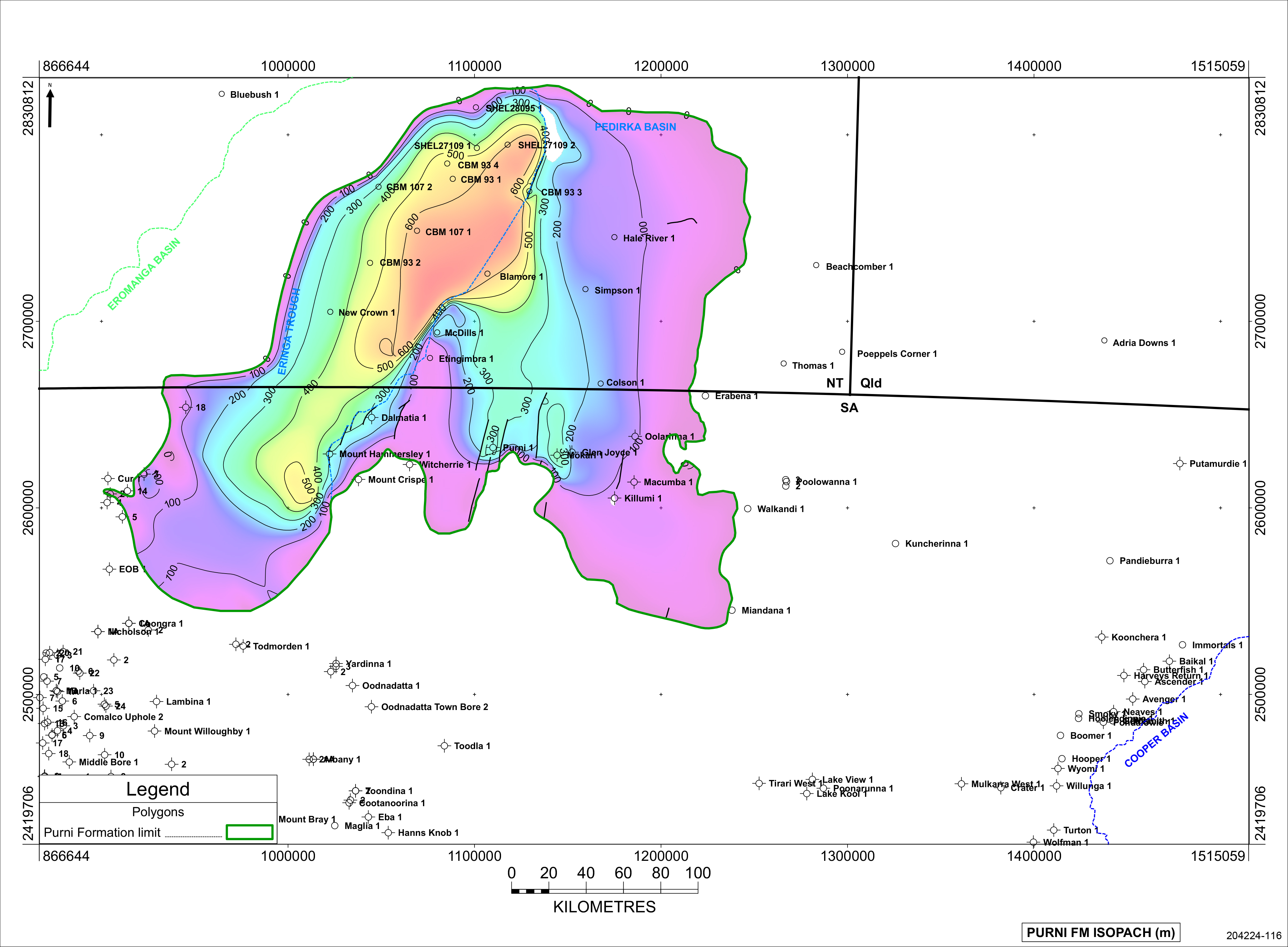
Thickness of the Purni Formation in the Pedirka Basin
Cores were cut in the Purni Formation in Purni 1 and Mokari 1 in South Australia and McDills 1 and 6 CBM wells in Northern Territory.
Three cores were cut in the Purni Formation in Purni 1, the type well for the formation:
Core 2 – 4,731’-4,778’, 100% recovery; Upper Purni
- Grey white, fine grained, carbonaceous sandstone, very rich in coal fragments, micaceous; overlying
- Grey white carbonaceous sandstone, with kaolinitic cement
- 4,740ft – 19.6% porosity
- 4,742ft – 22.0% porosity
- 4,743ft – 16.2% porosity
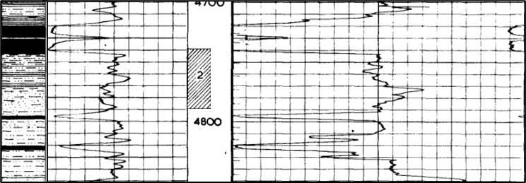
Upper Purni, excerpt from Purni 1 Composite Log
Core 3 – 5,066’-5,096’, 90% recovery; Middle Purni
- Grey medium sorted sandstone; overlying
- Carbonaceous silt, very compact; overlying grey brown fine to medium, well sorted and subangular sandstone
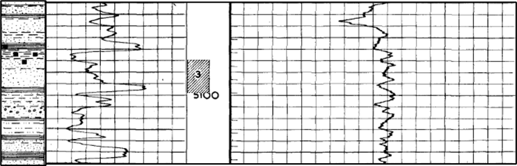
Middle Purni, excerpt from Purni 1 Composite Log
Core 4 – 5,225’-5,315’, 100% recovery; Lower Purni
- Fine grained silty sandstone within carbonaceous veins; overlying
- Grey shales with grey sandstone lenses and thin coal levels
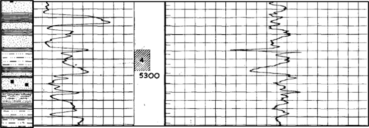
Lower Purni, excerpt from Purni 1 Composite Log
There are no photographs of any of these cores. However, a photograph was taken of part of core 3 in Mokari 1.
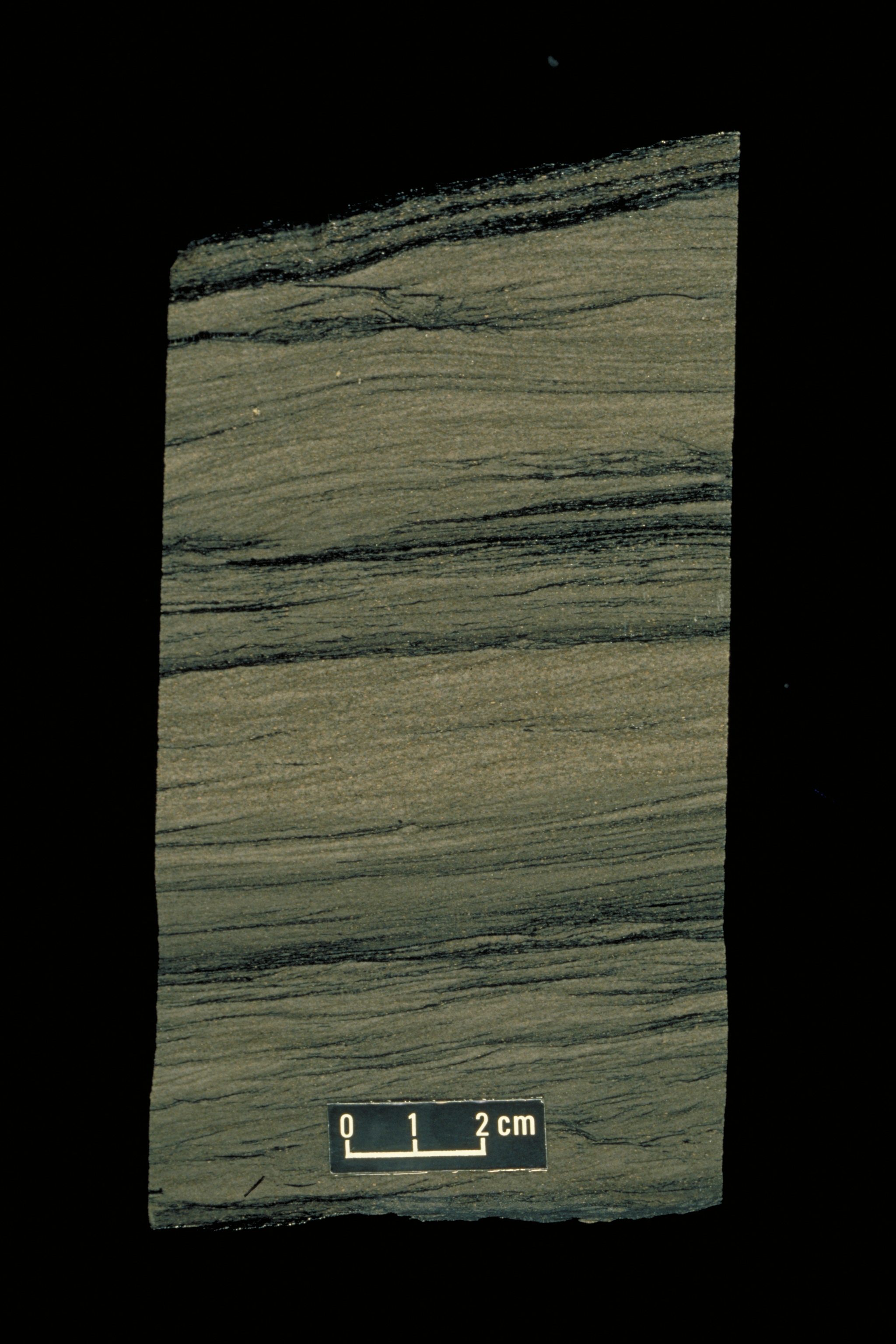
Photograph of the Purni Formation at 1998m from Core 3 in Mokari 1, showing finely laminated fine-grained, silty cross-bedded sandstone and carbonaceous shale (Alexander et al, 2007)
Cores were cut in wells CBM 107 01, CBM107 02, CBM93 01, CBM93 02, CBM93 03 and CBM93 04 in Northern Territory. All wells have been hylogged, and interpretation is under way.
Drill stem tests (DSTs) were conducted over the Purni Formation in Mokari 1 (1966), Macumba 1 (1977), Blamore 1 (2008) and CBM 93-01 (2008):
Mokari 1:
- DST 2 - 6,468ft to 6,557ft (Upper Purni) – misrun
- DST 3 - 6,593ft to 6,693ft (Middle Purni)
- The DST data sheet in the WCR Appendix 9 Interpretation of Test Results records “Good blow when opened increasing to very strong. Mud to surface in 13 mins. after opening. … Water flowing at rate approx. 2400 gall/hr (387 c.ft/hr.)”
- However, there must be some doubt about the recovery and hence the rate:
- WCR Appendix 8 Record of Tests suggests “Fluid to surface in 17 min.”, with water recovered at 387 cu ft/hr.
- Coincidentally, this is precisely the same rate reported for the water flow from DST 1 over the Poolowanna Formation, which is reported elsewhere in the WCR as having much better porosity than the Purni (14.9% vs 10.4%) and hence better flow rates
- NB 387 cu ft/hr equates to a flow rate of 1,654BWPD
Macumba 1:
- DST 1 - 8,211ft to 8,283ft (Lower Purni)
- Recovered 4,350ft of slightly gas-cut water in 90 minutes. Top 200ft muddy
- Calculated water flow rate of 869BPD
Blamore 1:
- 3 DSTs were also run in Blamore 1 but they were all misruns
CBM 93-01:
- DST 1 - 798.2m to 810.9m (Upper Purni)
- Run over a 6m coal
- An initial moderate blow declined to weak during the flowing period
- The test was conducted to assess coal seam permeability and as expected fluid recovery was formation water.
- The test was successful recording a moderate flow of formation water into the drill pipe
- DST 2 - 973.13m to 1007.2m (Upper Purni)
- Run over a 35m coal section
- A very strong blow decreasing to a strong blow
- The test was conducted to assess the permeability of a coal seam
- The test was successful recording a moderately strong flow of formation water into the drill pipe
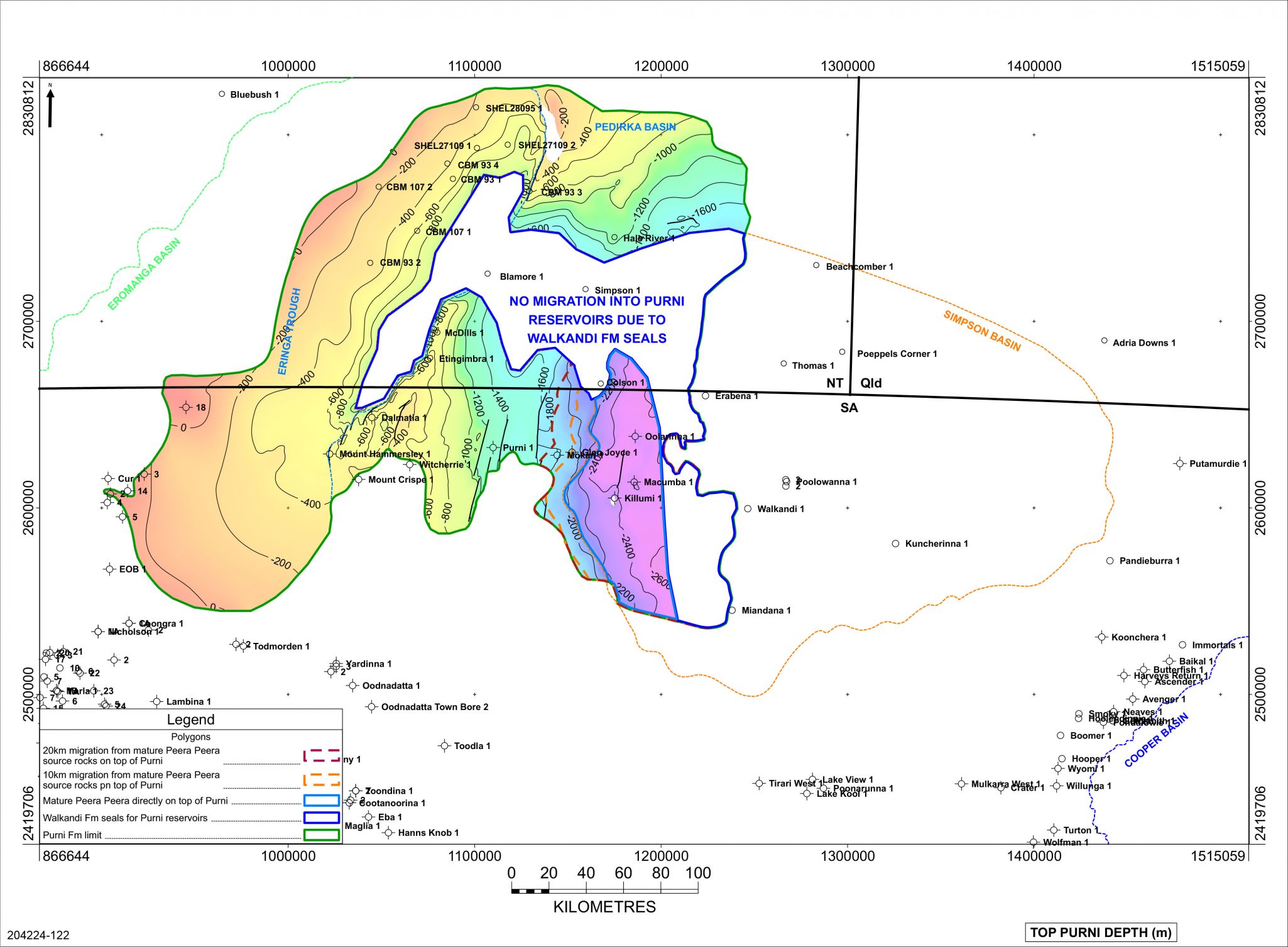
Adequate seals for Purni Formation reservoirs are likely to be provided primarily by intraformational flood plain and lacustrine sediments. The upper member of the formation consists primarily of carbonaceous shale interbeds with abundant coal seams, so is likely to act as a good seal to the mainly sandy middle member, as well as any sandstone reservoirs within the upper member.
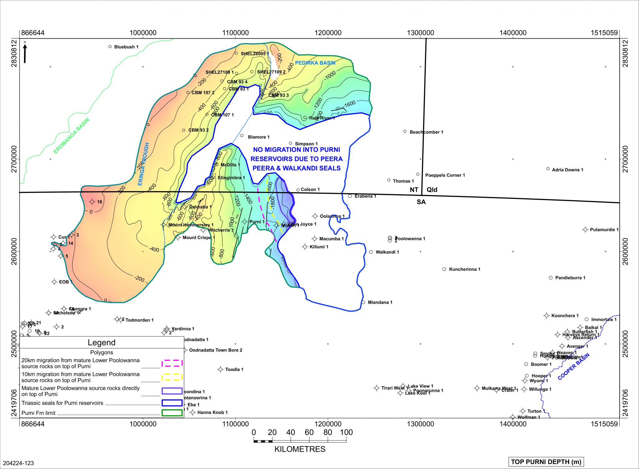
Over the eastern and central parts of the basin the Triassic Walkandi and Peera Peera Formations overlie the Purni Formation, providing additional seal.
Intense east-west compression and local wrenching during the Miocene resulted in structural rejuvenation and breach of fault seal in the Poolowanna Trough region, resulting in residual hydrocarbons in the Poolowanna and Peera Peera Formations in Poolowanna 1. This may have occurred with Purni structures as well so must be considered when drilling for Purni targets.
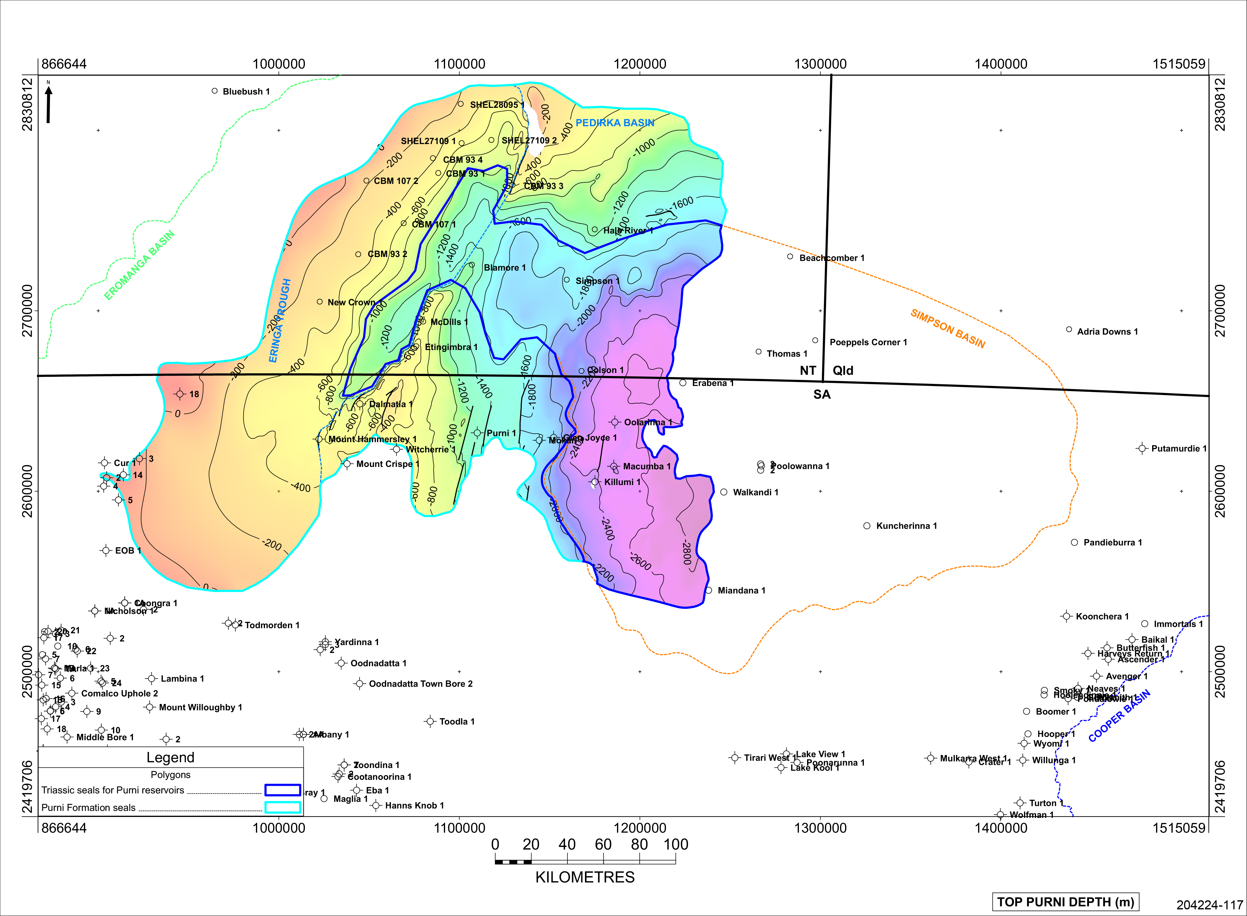
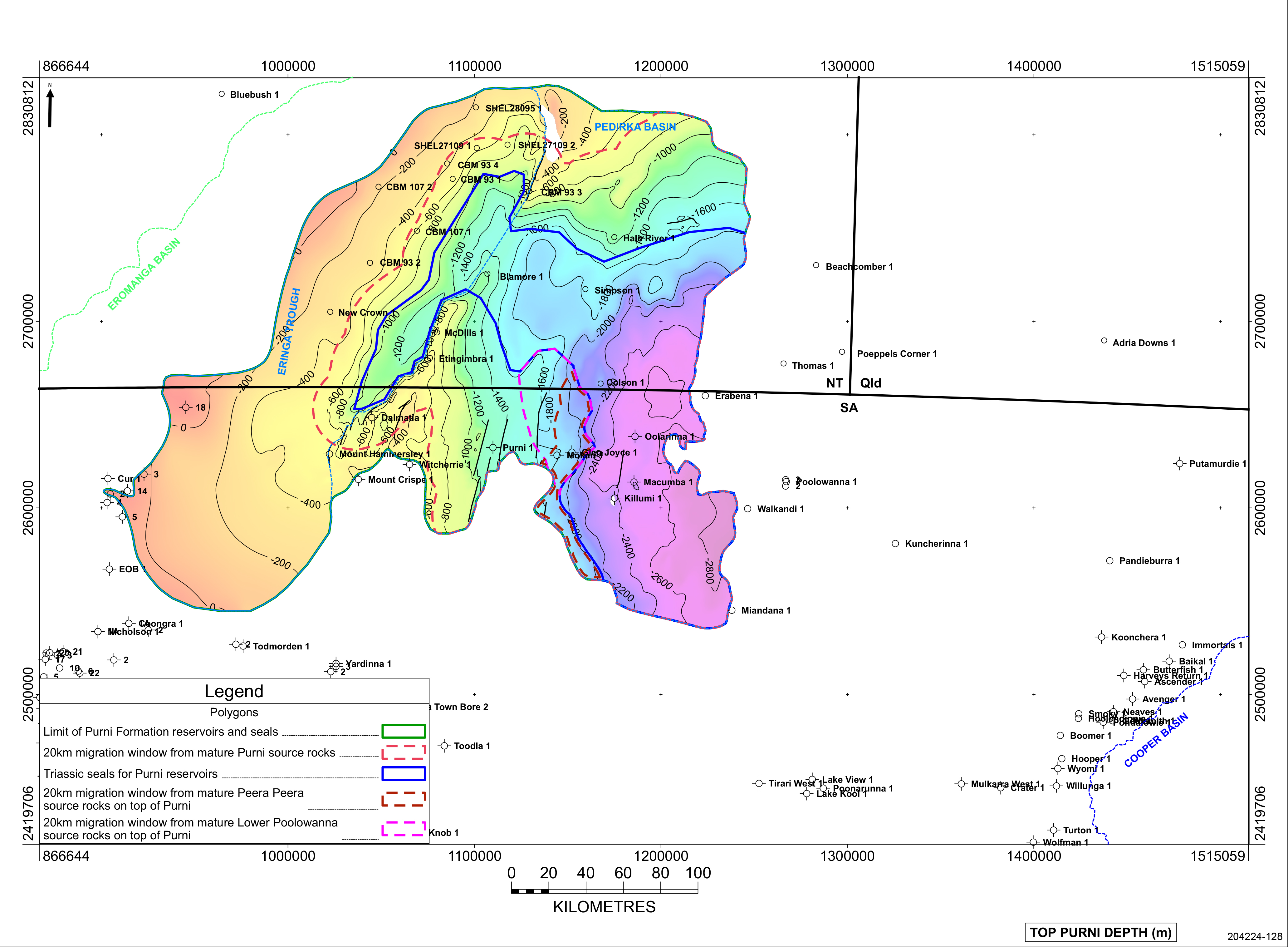
Extent of the seals for Purni Formation reservoirs in the Pedirka Basin
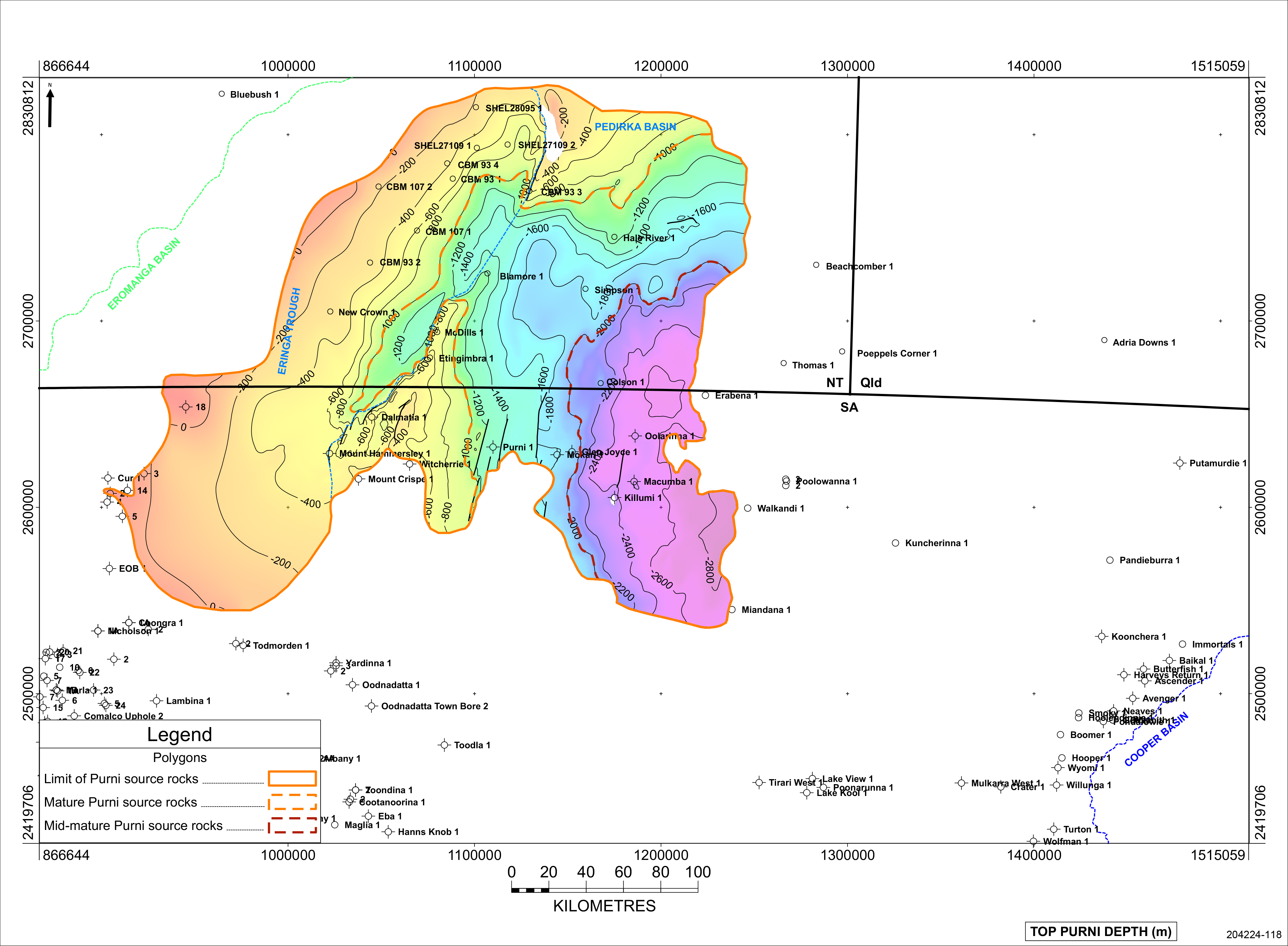
No hydrocarbon shows have been recorded over the Purni Formation in the Pedirka Basin to date, other than gas shows associated with coals. However, there are three intervals in the Pedirka Basin region that contain suitable material to have acted as potential source rocks for charge of hydrocarbons into Purni reservoirs:
- Purni Formation – intraformational coal measures and carbonaceous shales lying adjacent and above the reservoirs are the most likely,
- Middle to Late Triassic Peera Peera Formation of the Simpson Basin
- The Early Jurassic Lower Poolowanna of the Eromanga Basin
The Peera Peera and Lower Poolowanna are both stratigraphically younger than the Purni and lie above the target, so are likely to have sourced hydrocarbons only in potential stratigraphic closures on the flanks of the basins, where they may act as seals as well.
Purni Formation, Pedirka Basin
The Permian Purni Formation in the Pedirka Basin is the equivalent of the Patchawarra Formation, which is the source for much of the gas and oil discovered in the Cooper and Eromanga Basins. It contains the richest source rocks in the Pedirka Basin-Poolowanna Trough region, with extensive coal-rich organic shale which appears to be both oil and gas-prone. It contains up to 4% dispersed organic matter, with vitrinite and exinite macerals present in moderate abundance.
Radke (2009) reported both the upper and lower members of the Purni Formation as having good to excellent source rock potential. They consist of alternating shale, coal and siltstones deposited in lacustrine, swamp and floodplain settings, with the coals being the richest source rocks, comprising predominantly vitrinite and inertinite, with exinite generally less than 5% (but up to 20%). DOM in carbonaceous shales is generally poor. In the eastern Pedirka, Purni Formation sediments contain both H–rich exinite and vitrinite, and H-poor vitrinite rich source rocks
2008 drilling in the Northern Territory by Central Petroleum established extremely thick coal accumulations away from structural highs. CBM 93-01 intersected 593m of Purni, with a total 153m of coal in seams greater than 0.2m, also assessed as a total of 138m of coal in seams greater than 2.0m thickness. Blamore 1 encountered a total 160m of coal in seams greater than 0.2m, also assessed as a total of 132m of coal in seams greater than 2.0m thickness. The isopach of the Purni Formation suggests there may be over 660m of section in the Eringa Trough in the Northern Territory, and the large amount of coal present had the potential to generate reasonable quantities of hydrocarbons.
Maturity of the Purni Formation source rocks in the Pedirka Basin
Peera Peera Formation, Simpson Basin
The Triassic Peera Peera Formation offers fair to good source potential. The Poolowanna 1 Well Completion Report indicated “The uppermost 60 feet of this section consists of black, silty, very organic rich shale, and appears to be an excellent source rock”, and that the formation “appears to be less prospective for liquid hydrocarbons than the Lower Jurassic section, although higher yields of kerogen have been attained in the upper part of the Peera Peera Formation.” The WCR also noted “A large sonic travel time shift (18 microseconds per foot, maximum) indicates the high organic content of this silty shale, which seems to be the main source of hydrocarbons in the area.”
The Peera Peera is rich in Type III kerogen organic matter (TOC around 4-5% although up to 18% in places). Ambrose et al (2007) reported Hydrocarbon Index of 100-200 with yield of 5-11kg/tonne in Macumba 1 (1977), suggesting a source for mixed gas and liquids, which is consistent with the gas flowed to surface from the Peera Peera in Poolowanna 1, albeit at a rate too small to measure. Radke (2009) noted that generally the DOM is higher towards the top of the unit and inertinite is dominant, and that much of the source potential of this unit lies in its abundant coals which have comparable macerals to those in the overlying Poolowanna Formation. He stated that the formation appears to be predominantly gas-prone but with potential for a modest oil yield.
The Peera Peera Formation of the Simpson Basin is stratigraphically younger than the Purni, and so is only likely to have been a source in the easternmost Pedirka Basin, where there may have been direct migration of hydrocarbons into the Purni Formation reservoirs if they were in communication at time of migration.
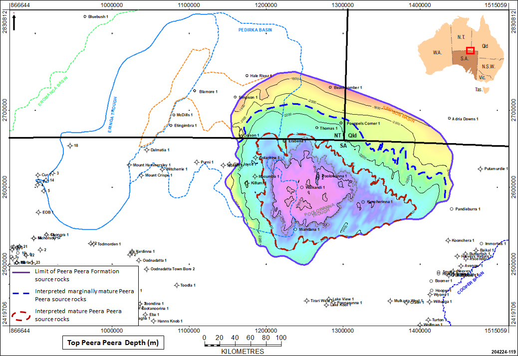
Maturity of the Peera Peera Formation source rocks in the Simpson Basin
Lower Poolowanna Formation, Eromanga Basin
The middle section of the Poolowanna Formation is considered to have good potential as a source rock in the Poolowanna Trough: the Poolowanna 1 Well Completion Report indicated “A 40 foot interval within the Poolowanna Formation offers the best source rock potential of the well. The kerogen from this interval included about 25 % diffuse sapropelic material that is rich in exinite, but also in inertinite.”
The Poolowanna Formation source rocks are primarily at the top of the Lower Poolowanna. Coals and coal-related lithologies are volumetrically important in the sequence, with maceral composition ranging from vitrinite and vitrinite-rich clarite through a range of trimacerites to durite (Radke, 2009). Inertinite is dominant in dispersed organic matter (DOM) but vitrinite is also abundant. At Poeppels Corner 1, woody herbaceous DOM is rich in exinite. The coals have good to excellent source richness with total organic carbon (TOC) up to 15%, possess good oil generative potential, and have reached peak maturity of 0.9 % Ro in the Poolowanna Trough.
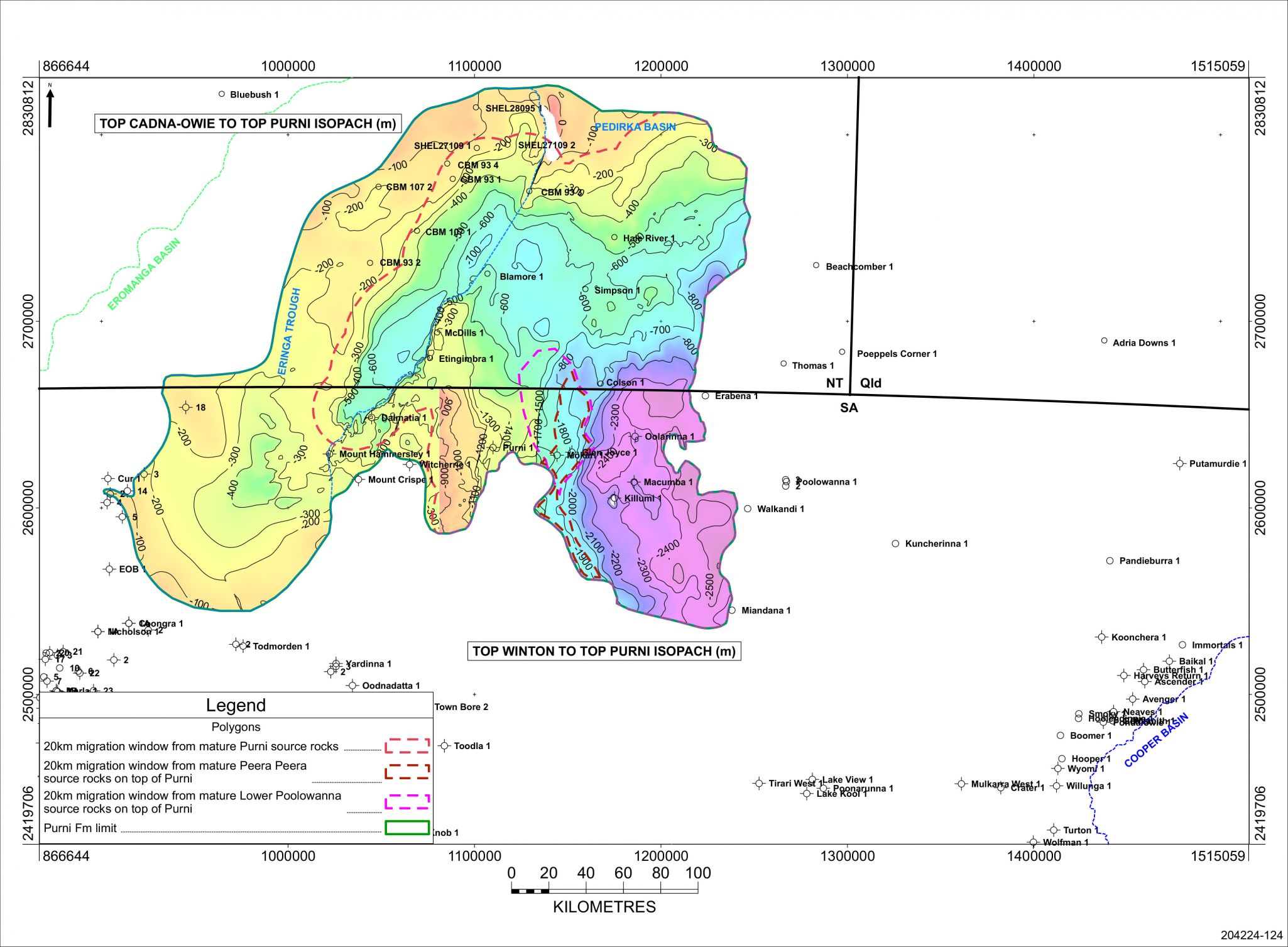
The Lower Poolowanna is stratigraphically above the Purni so is likely to have sourced hydrocarbons only in potential stratigraphic closures where it is in direct communication with the immediately underlying Purni on the flanks of the Poolowanna and Eringa Troughs, where it may act as a seal as well.
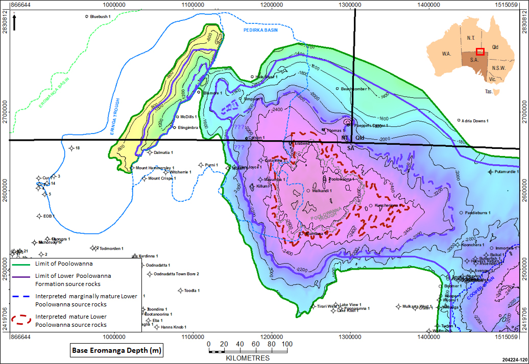
Maturity of the Lower Poolowanna Formation in the Poolowanna Trough and the Eringa Trough
Source rock maturity
Onset of oil generation (Ro=0.5%) would generally be expected with burial at 1500m, and peak oil generation (Ro=0.7%) at 2200m Radke (2009), although of course this depends upon the types of organic matter present and the local geothermal gradient. Gas generation is expected from 0.6% Ro at 1900m.
In much of the Pedirka Basin geothermal gradients are low and so sediments may not have generated significant quantities of hydrocarbons, but the Early Jurassic (Poolowanna) and Permo-Triassic sequences have reached the main oil generative window (Ro 0.7-0.9%) over large portions of the Pedirka Basin and Poolowanna Trough.
Basin modelling in the Poolowanna Trough by Ambrose et al (2007) suggested that early onset of oil generation commenced from the Peera Peera Formation in the Early Cretaceous around 135Ma; this suggests that this may have occurred potentially earlier from the Purni Formation in the eastern Pedirka Basin. Peak generation and expulsion from all source rocks occurred primarily in the early part of the Late Cretaceous(100-90Ma) following significant subsidence during the deposition of the Winton Formation.
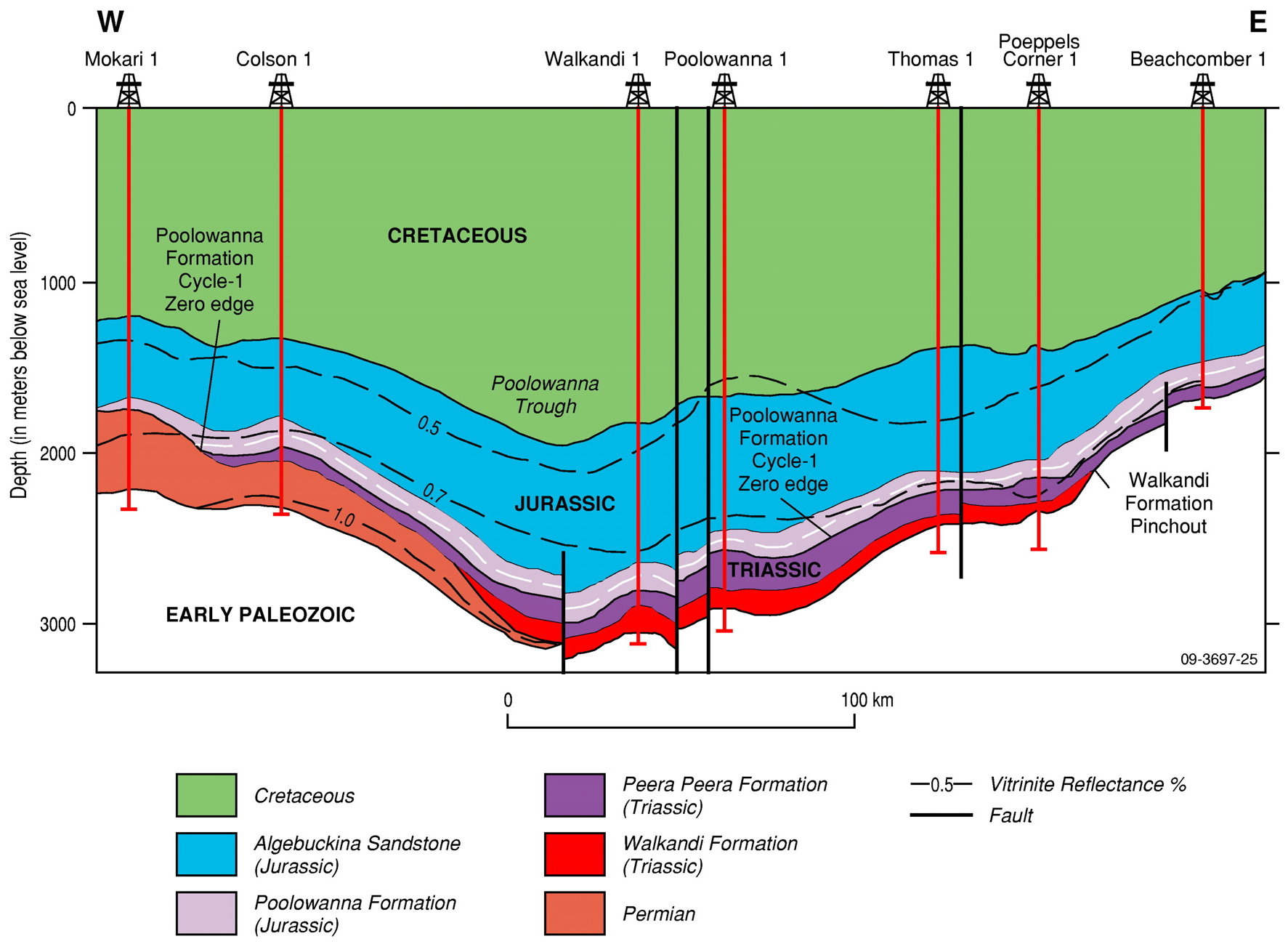
Cross section of the Poolowanna Trough with isoreflectance contours, showing maturity of the sequence up to the basal Jurassic, and a progressively shallower mature sequence to the east (from Radke, 2009, modified from Ambrose et al, 2007)
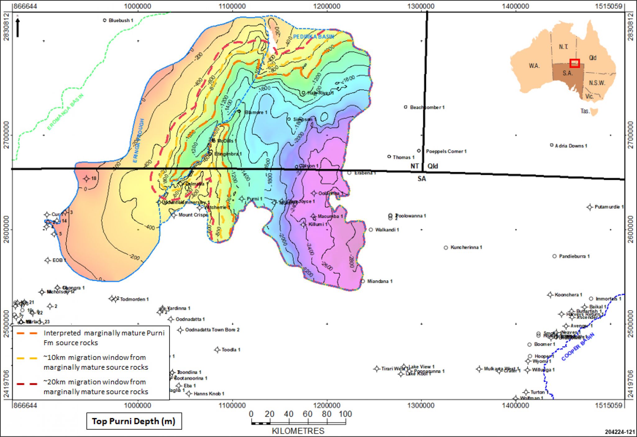
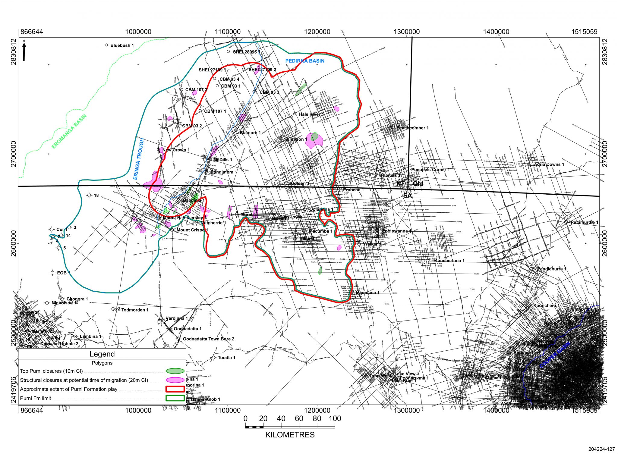
Three intervals contain suitable material in the Pedirka Basin area to have acted as potential source rocks for charge of hydrocarbons into the Purni reservoirs:
- Direct charge from Purni source rocks into adjacent and underlying Purni reservoirs in the Pedirka Basin
- The Purni sandstone reservoirs are interbedded and directly overlain by potential source rocks of the same age, and therefore charge into reservoirs is likely from areas where the source is mature, including updip of the mature source due to the porous and permeable carrier bed system
- Purni source rocks are mature over most of the Pedirka Basin
- Lateral charge from Peera Peera source rocks in the Simpson Basin into Purni reservoirs in the Pedirka Basin
- The Peera Peera is stratigraphically above the Purni on the western flank of the Simpson Basin so may have sourced hydrocarbons in potential closures
- This could occur on the eastern flank of the Pedirka Basin
- Lateral charge from Lower Poolowanna source rocks in the Eromanga Basin into Purni reservoirs in the Pedirka Basin
- The Lower Poolowanna is stratigraphically above the Purni and directly overlies it in the western Pedirka Basin so may have sourced hydrocarbons in potential closures
- However, there is little overlap between the distribution of the mature Lower Poolowanna source rocks and the Purni Formation reservoirs, so charge should be deemed more unlikely than probable
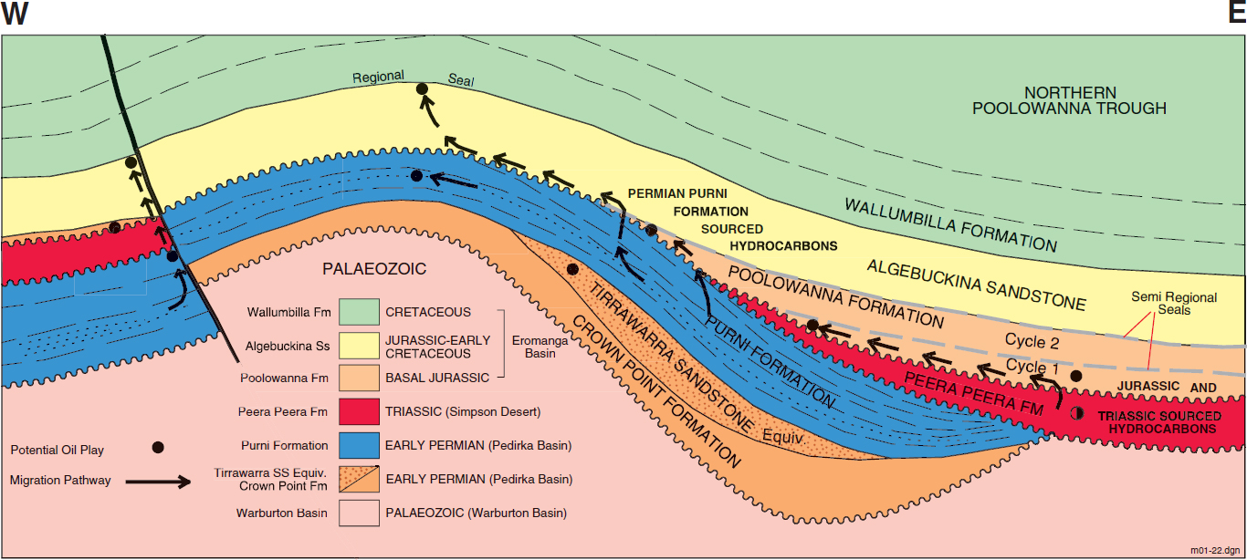
Pedirka, Simpson and Eromanga Basins play types and potential migration pathways (Ambrose et al, 2002)
Up to 20km migration distance from mature source rocks is generally regarded as a reasonable migration distance within porous reservoirs, although Borazjani et al (2019) stated that in the Cooper-Eromanga basins “the migration of expelled oils to Jurassic reservoirs was relatively fast given the short pathway distances of <1 km (fault migration) and ~40 km (carrier bed pathway)”. In this play analysis study 20km migration distances have been used outboard of mature source rock areas.
|
|
|
Trapping mechanisms in the Pedirka Basin are likely to be dominated by anticlines with 4-way dip closure over pre-existing, “basement” highs, although onlap and pinch-out traps against Warburton Basin highs are expected along the eastern flank of the Dalhousie-McDills Ridge.
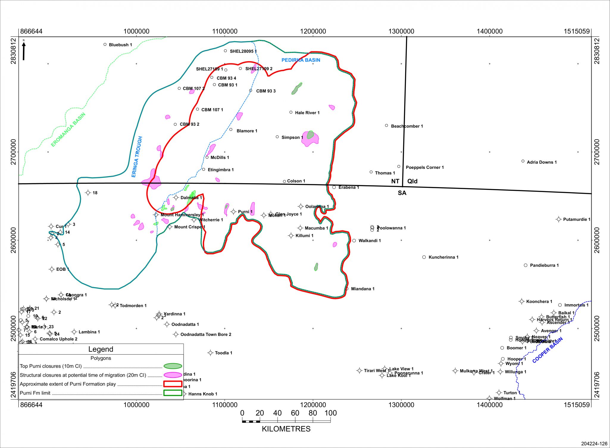
An example of an anticlinal trap may occur in the Eringa Trough. Figure 5 in the CBM 93-01 Well Completion Report is an interpretation of seismic line CB08-01 from CBM 93-01 and Blamore 1, showing potential flat spots within the Purni section.
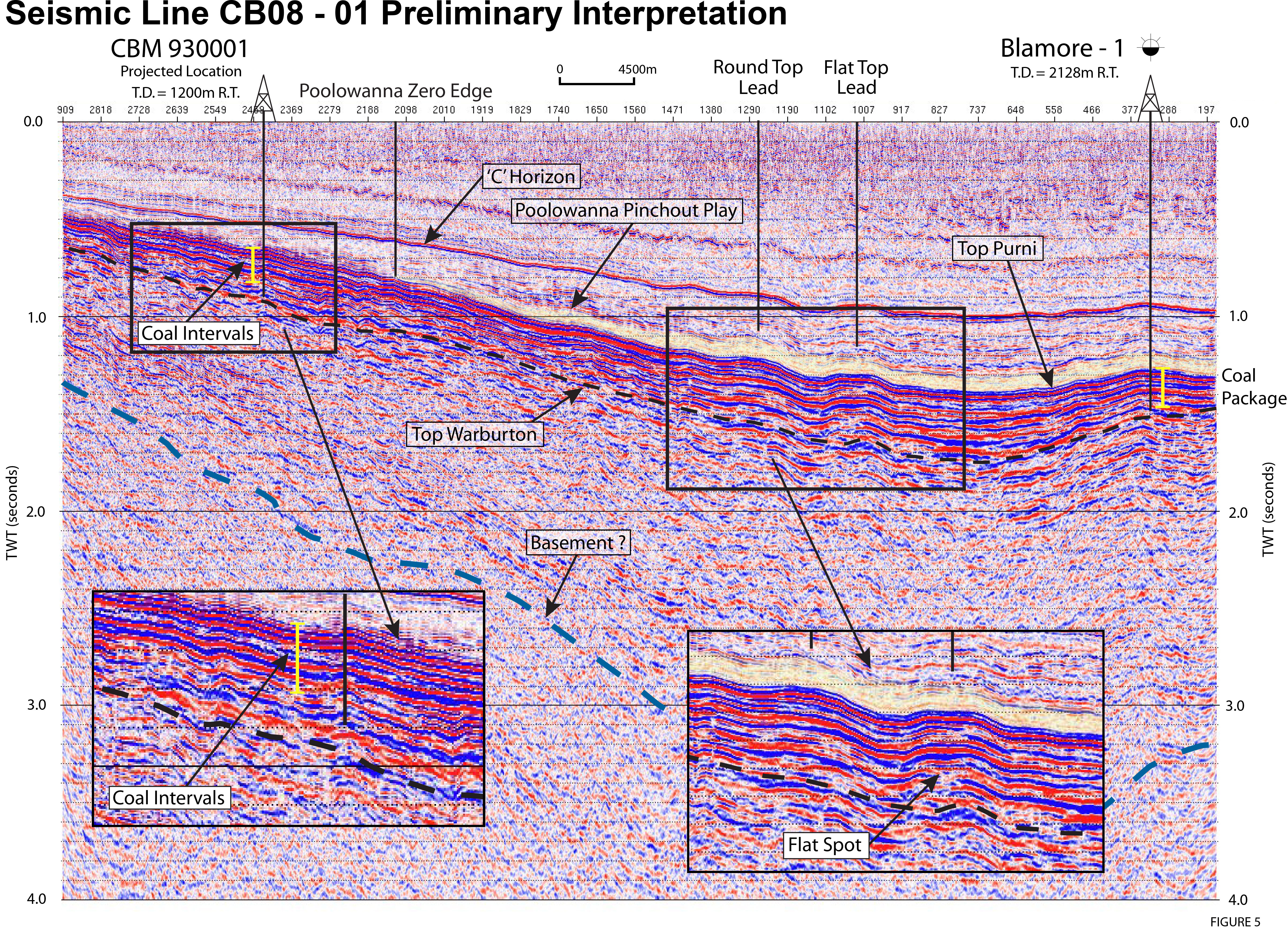
Figure 5 from the CBM 93-01 Well Completion Report
Structures to be investigated must have been in place prior to major generation and expulsion of hydrocarbons, so those that formed during the Cainozoic are less favourable prospects than those formed prior to end of deposition of the Late Cretaceous Winton Formation.
Intense east-west compression and local wrenching during the Miocene resulted in structural rejuvenation and breach of fault seal in the Poolowanna Trough area. This would explain why only residual hydrocarbons were encountered in the Poolowanna Formation in Poolowanna 1. Therefore, exploration is required of more subtle structures not affected by the reactivation in the Miocene.
Stratigraphic traps are also potential targets, in particular pinch-outs on the flanks of the basin.
In the Cooper-Eromanga Basins a common technique for estimating whether a present day structure is likely to have been charged with hydrocarbons or not is to look at the isopach between the top of the Winton Formation and the top of the target formation; this map approximates the target surface structure at time of migration, with thin isopach areas indicating potential structures at time of migration. If there is no top Winton surface mapped in the area of interest the isopach between the top of the Cadna-owie Formation and the target formation is used as a proxy. This technique is applicable to the Purni Formation in the Pedirka Basin as well.
It must be borne in mind that the coverage of 2D seismic data within the Pedirka Basin is limited compared to that in the Cooper Basin to the south-east. Consequently, structures in reality may be quite different to the way they have been mapped.
|
Structural closures within the Purni Formation at potential time of migration (PDF 613 KB) |
|  |
Play elements for the Purni Formation in the Pedirka Basin
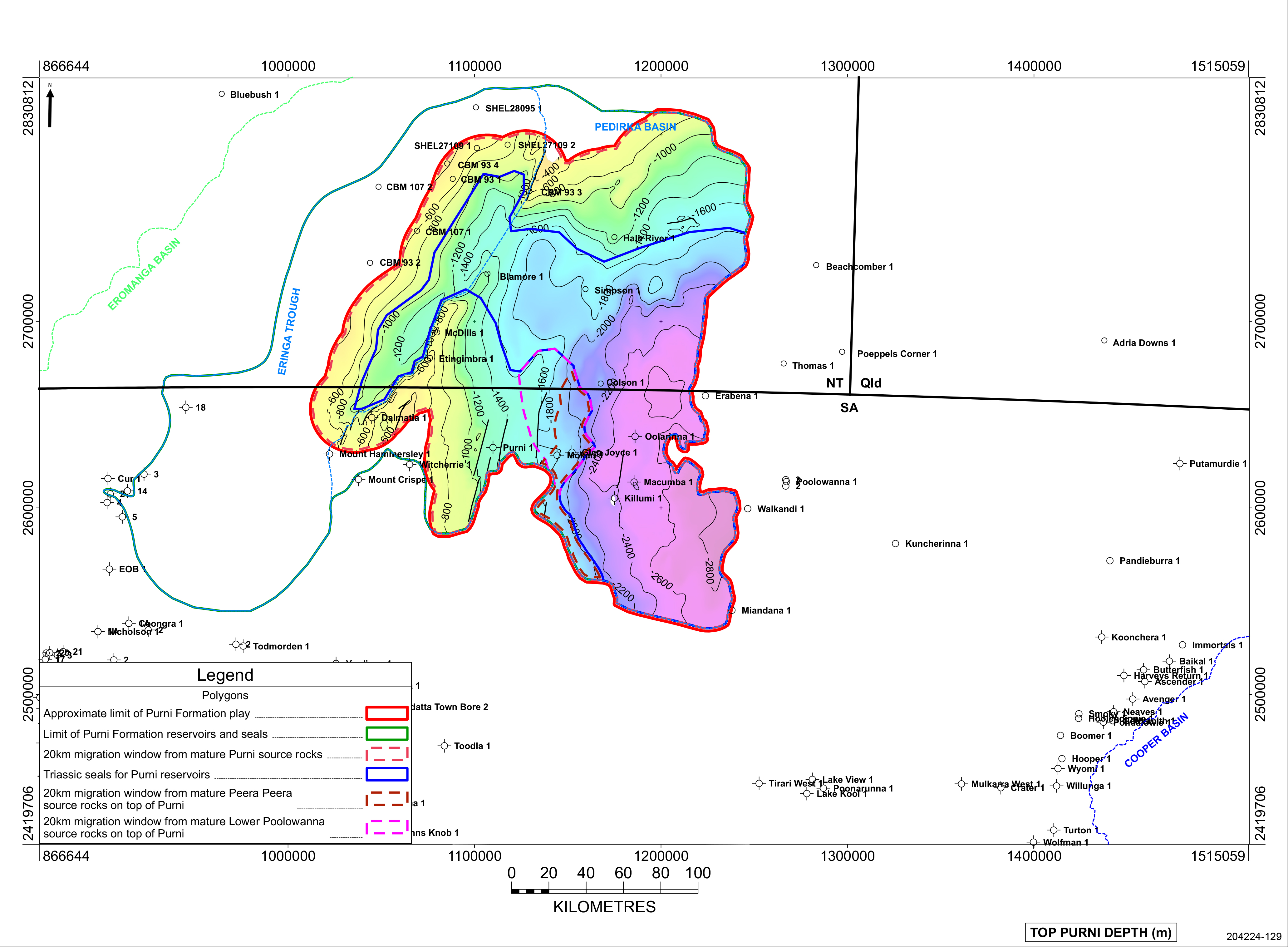
Approximate extent of the Purni Formation play in the Pedirka Basin
| Proven production from the Purni Fprmation: | None |
| Number of producing wells at 28 February 2021: | None |
| Total production at 28 February 2021: | None |
| Hydrocarbon flow rates: | Calculated water flow rate of 869BPD in Macumba 1 |
There is no estimate of undiscovered resources.
Alexander EM and Jensen-Schmidt B, 1995. Eringa Trough exploration opportunity. South Australia. Department of Mines and Energy. Report Book, 95/00036.
Alexander EM, Pegum D, Tingate P, Staples CJ, Michaelsen BH and McKirdy DM, 1996. Petroleum potential of the Eringa Trough in South Australia and the Northern Territory. APEA Journal, 36(1):322-349.
Alexander EM and Boult, PB, 2007. Reservoirs and seals; Chapter 11 in Cotton, TB, Scardigno, MF, and Hibburt, JE, eds: The Petroleum Geology of South Australia. Vol. 2: Eromanga Basin. 2nd edn; South Australia Department of Primary Industries and Resources. Petroleum Geology of South Australia Series.
Alexander EM, Sansome, A and Cotton, TB, 2007. Lithostratigraphy and environments of deposition; Chapter 5 in Cotton, TB, Scardigno, MF, and Hibburt, JE, eds: The Petroleum Geology of South Australia. Vol. 2: Eromanga Basin. 2nd edn; South Australia Department of Primary Industries and Resources. Petroleum Geology of South Australia Series.
Ambrose, G and Heugh, J (2012): The Geology of the Pedirka Basin Coal Measures in the Purni Formation, Simpson Desert Area. Proceedings Central Australian Basin Symposium III, Special Publication 2. Alice Springs, 16-17 July, 2012. Petroleum Exploration Society of Australia.
Ambrose, GJ, Liu, K, Deighton, I, Eadington, PJ, and Boreham, CJ, 2002: New petroleum models in the Pedirka Basin, Northern Territory, Australia; The APPEA Journal, 42(1): 259-286.
Ambrose, G., Scardigno, M., and Hill, A.J., 2007: Petroleum geology of Middle-Late Triassic and Early Jurassic sequences in the Simpson Basin and northern Eromanga Basin of Central Australia; The APPEA Journal, 47(1): 125-142.
Borazjani, S, Kulikowski, D, Amrouch, K and Bedrikovetsky, 2019: Composition changes of hydrocarbons during secondary petroleum migration (case study in Cooper Basin, Australia); Geosciences, 9(2), 78
Carne, GE and Alexander, EM, 1997. Eromanga Basin prospects inventory, Blocks ER97-A to C, Exploration opportunity. South Australia. Department of Mines and Energy Resources. Report Book, 97/00021.
Giuliano MF, 1988. The geology and hydrocarbon potential of the Pedirka Basin. University of Adelaide. National Centre for Petroleum Geology and Geophysics. BSc (Hons) thesis (unpublished).
Munson, TJ, 2014. Petroleum geology and potential of the onshore Northern Territory, 2014. NTGS Report 22
Radke, B., 2009: Hydrocarbon & Geothermal Prospectivity of Sedimentary Basins in Central Australia. Record 2009/25. Geoscience Australia, Canberra.
Strong, P.C. 2024. Play analysis in the Pedirka Basin-Poolowanna-Trough region. Central Australian Basins Symposium IV, Vol 2. PESA.
Strong, PC, Wood, GR, Lang, SC, Jollands, A, Karalaus, E and Kassan, J, 2002. High resolution palaeogeographic mapping of the fluvio-lacustrine Patchawarra Formation in the Cooper Basin, South Australia; The APPEA Journal 42(1), 65-81
Wohling, D, Keppel, M, Fulton, S, Costar, A, Sampson, L and Berens, V, 2013. Australian Government initiative on coal seam gas and large coal mining: Arckaringa Basin and Pedirka Basin groundwater assessment projects. South Australia Department of Environment, Water and Natural Resources Technical Report DEWNR 2013/11
Youngs, B.C., 1975. The Early Permian Purni Formation of the Pedirka Basin. South Australia. Geological Survey Quarterly Geological Notes, 54:8-12.