
The Ultrafine+TM project is a collaboration with CSIRO Minerals and aims to develop an innovative soil sampling workflow, which will help identify gold and other commodities in the search for potential exploration targets.
Project summary
The UltraFine+ project is taking soil samples to analyse for gold and other commodities. This survey technique has been widely used for decades, however the UltraFine+ workflow promises to hone in on metal targets through the combination of analytical and spatial technologies at LabWest Minerals Analysis Pty Ltd, located in Perth, Western Australia.
Soil sampling is a useful tool in exploration. Traditionally, particles around 250 microns (quarter of a millimetre) were considered the smallest fraction of soil that could be analysed. However, the UltraFine+ process, developed in partnership between LabWest and CSIRO Minerals, focuses on particles less than 2 microns in size.
Vegetation sampling was also conducted at each UltraFine+ soil site, as a comparative dataset to better understand the rock-soil-plant relationship.
These ultra-fine soil particles, such as clays and iron oxides, have more surface area which can bind gold and other metals that move through the environment, and so form geochemical signatures of orebodies laying many metres below soil or sand.
The Ultrafine+ project involves a physical step to retain the fine microparticles and a chemical step to test for the presence of gold and other elements.
The first part of the project is a year-long study which is based on an UltraFine+ soil survey within the highly prospective Central Gawler Craton.
This study focuses on the creation of an innovative workflow to test novel sample planning and modelling, which will aid in machine learning.
Research insights from the Central Gawler UltraFine+ survey geochemical data will be used to update survey maps of the region and help industry identify new exploration targets. This valuable dataset is supported by vegetation sampling and corresponding biogeochemical surveys co-located with the UltraFine+ soil sites.
The GSSA and department continues to support research to integrate UltraFine+ with regolith mapping and interpretation, and furthering the delivery of effective data products accessible to all mineral explorers, through our partnership with CSIRO within the M462a UltraFine+ Next Gen Analytics Project.
Project diary
June 2023
Dr Anna Petts presented How plants can provide dispersion pathways through cover and does it matter what you sample? A case for biogeochemical sampling in the Gawler Craton, South Australia at the Australian Earth Sciences Convention. This poster highlights her work on how plants can help us understand dispersion through cover.
Why focus on plants? Simply because they're everywhere! Species like chenopods (saltbush, bluebush), acacias, grasses such as spinifex, and eucalypts are commonly found in most regolith-landform units. These plants, with their deep taproots and resilience during dry seasons, help us analyse metal dispersion in the regolith cover. Even when the cover is deeper than 30 metres, plants interact with groundwater, soil gas, and other pathways, resulting in elemental concentration.
The study, conducted within the Central Gawler Craton, collected plant samples alongside UltraFine+ soil samples, aiming to understand the complex interactions in the critical zone. The poster presents the biogeochemical data, highlighting plant responses to different regolith materials, landforms, and lithologies. Chenopods like Pearl bluebush, Bladder saltbush and Black bluebush were extensively sampled, along with Mallee spp. and Mulga. Comparative analysis of soils and biogeochemistry results is also presented.
July 2022
Final reporting is underway for the Central Gawler project, which will be integrated with the concurrent biogeochemical sampling program (results coming soon). Sampling for UltraFine+ soil and vegetation, has also been completed and is now being interpreted for the Quondong Vale National Drilling Initiative target area and will be released later in 2022.
For more information about GSSA’s Ultrafine+ programs, watch GSSA geologist Anna Petts’ GeoHug presentation:
November 2021
Analysis and interpretation of the UltraFine+ and plant chemistry surveys for the Central Gawler program are progressing.
LabWest has been used for analysis of both plant and soil, and this research forms part of a larger collaboration between government and industry via a CSIRO-LabWest project.
For soil analysis, the UltraFine+ workflow at LabWest incorporates :
- Collection of <2 µm fraction from soil samples
- Analysis and reporting of Au plus full multielement suite by ICPMS
- Measuring the pH and conductivity of samples
- Sample particle size distribution information
- Visible and near infrared mineral proxies for the fines.
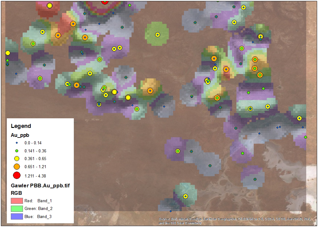
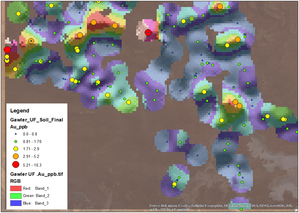
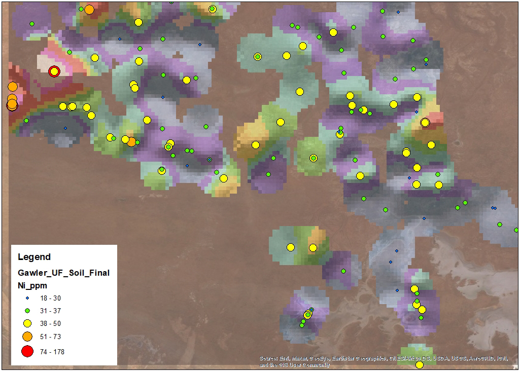
Results have been reported to GSSA and CSIRO. A quick check of the UltraFine+ soil results reflects the clay-dominant soil fraction sampled, with peaks for Al, Ca, Ce and Rb, related to analysed minerals Kaolinite, Montmorillonite, Muscovite with some Phengite, Illite and Paragonite as demonstrated in Figure 1.
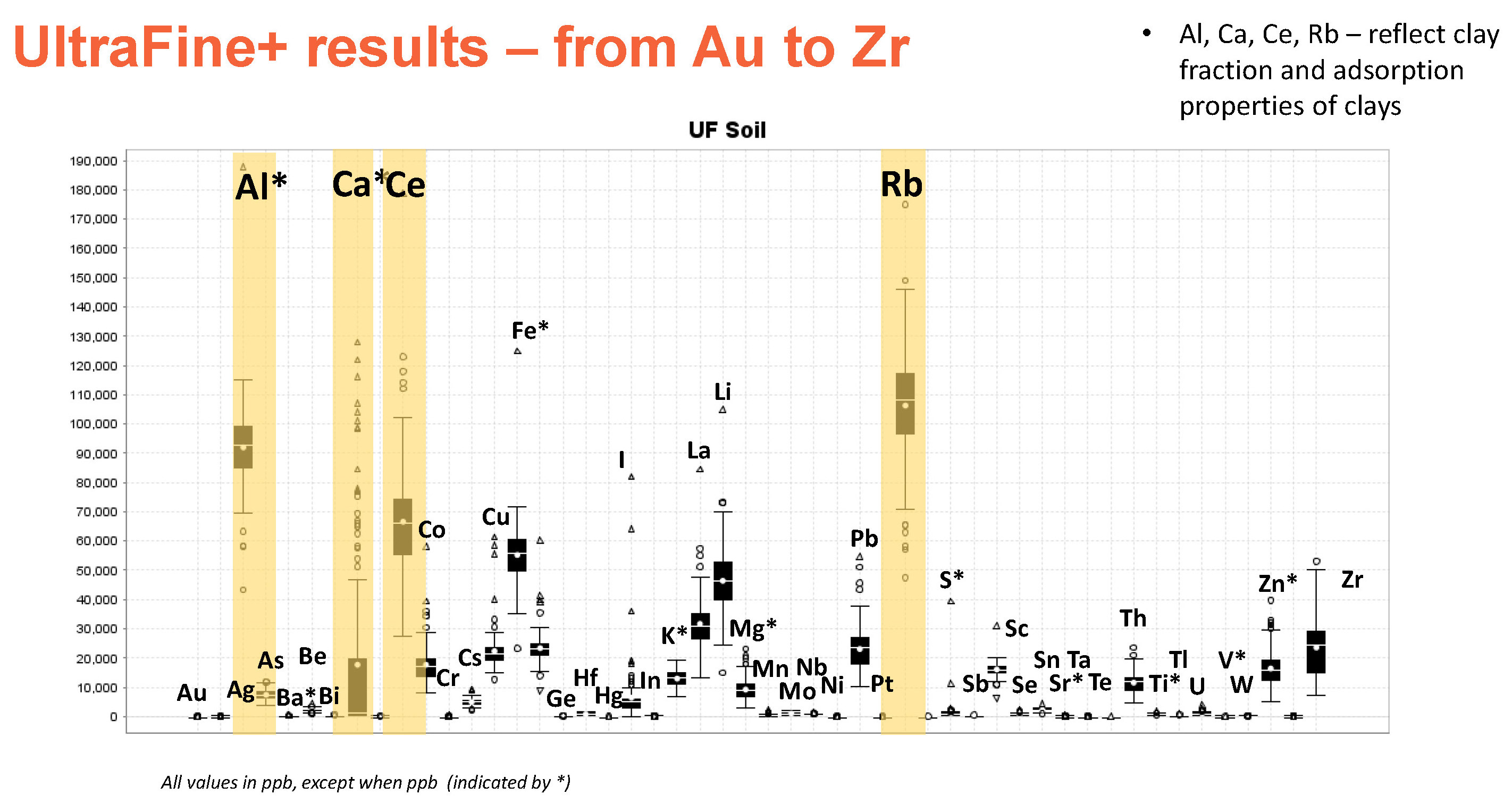
Figure 1
Plotted spatially, there is a good spread of background values across the large survey area (Figure 2). The patterns evident in this early data evaluation seem to relate to likely landscape position and climatic changes.
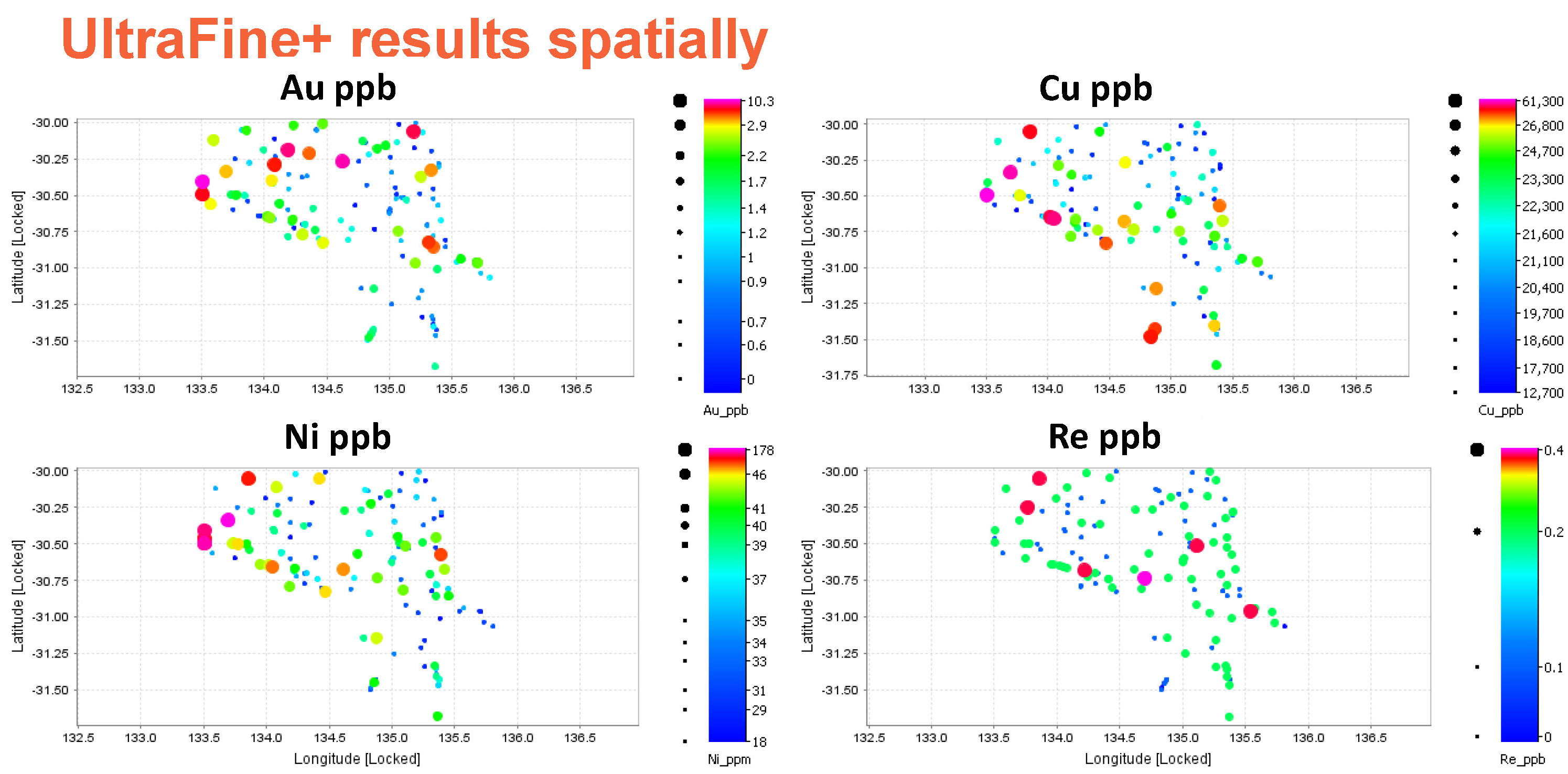
Figure 2
The biogeochemical samples were also sent to LabWest after drying and preparation at the South Australia Drill Core Reference Library. Leaf and twigs were separated for assaying. The samples were milled in a Retsch Mill with up to 2 g of sample digested by microwave assisted digest using a modified aqua regia solution at LabWest.
Biogeochemical results are being interpreted, with results to be reported in 2022. Figure 3 compares gold values across our main sampling media – Ultrafine plus soil, pearl bluebush, and bladder saltbush (both twigs and leaves included in the data). Pearl bluebush and bladder saltbush show a similar geochemical response to each other.
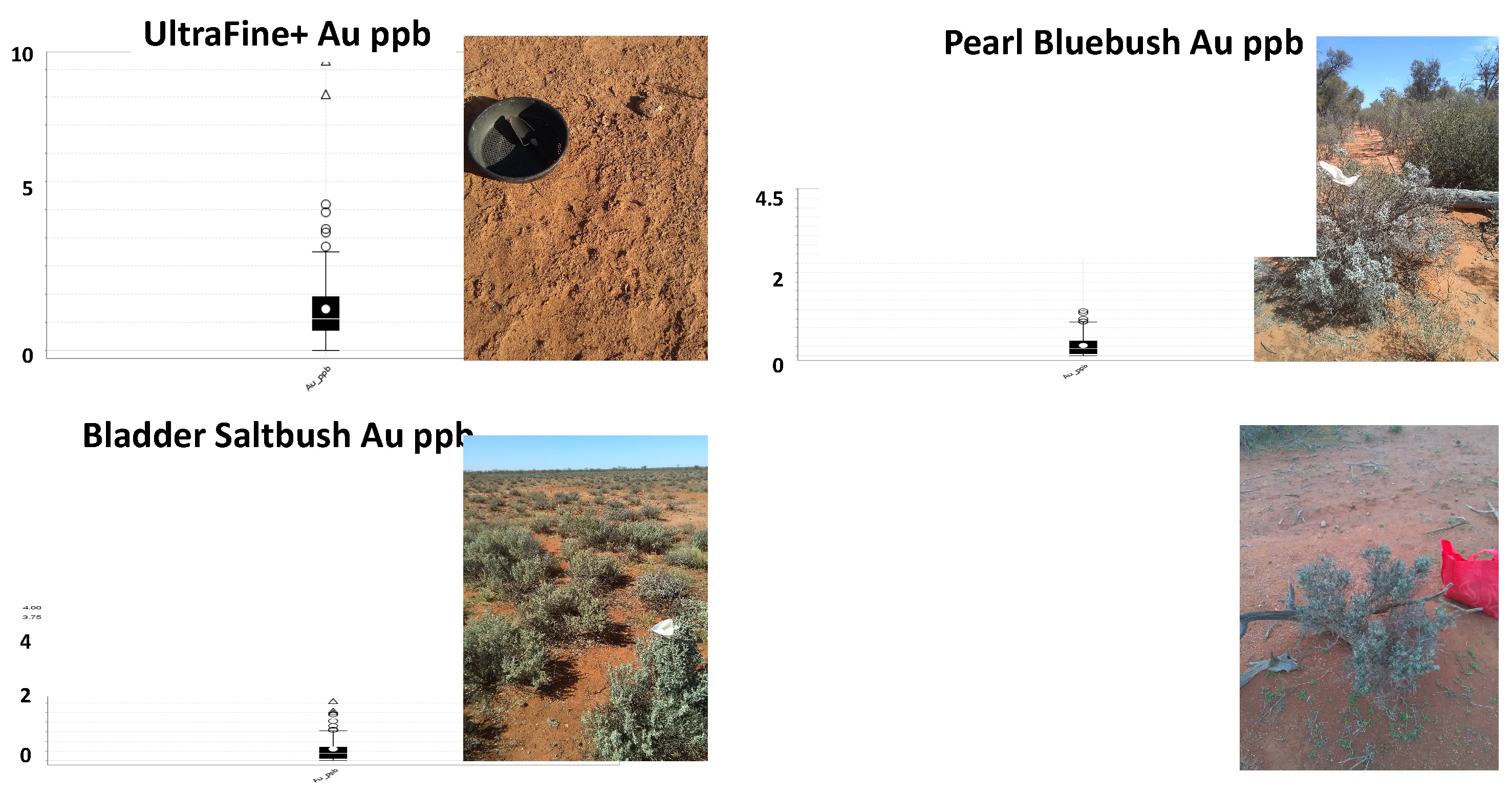
Figure 3
It is important to remember that this data represents background values which are close to detection limit. Further investigation and interpretation is required.
The following images show IoGas grids for Pearl bluebush leaf and twig samples plotted in ArcGIS with elemental concentrations.
August 2021
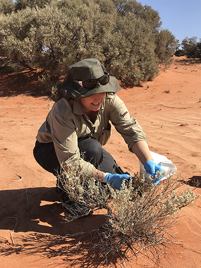
GSSA undertook fieldwork for the Central Gawler part of the project. The vegetation and soils samples have been analysed by LabWest in Western Australia.
November 2020
As part of Discovery Day 2020, Dr Anna Petts, GSSA and Dr Ryan Noble, CSIRO, discuss Ultrafine+ TM techniques that have been used to help understand the geochemistry of the Gawler Craton.
September 2020
Principal Geologist Dr Anna Petts and Senior Geochronologist Liz Jagodzinski demonstrate soil sampling for a study near Lake Harris, Kingoonya, while Senior Geologist Mark Pawley explains how mapping the rocks of a region is crucial to discovery.