Tom Wise1 and Stephan Thiel1, 2
1 Geological Survey of South Australia, Department for Energy and Mining
2 School of Physical Sciences, University of Adelaide
Download this article as a PDF (13.7 MB); cite as MESA Journal 92, pages 4–11
Published April 2020
Introduction
Methods of imaging the continental lithosphere provide a vital insight into the physical state and geometric architecture of the continents as we see them today. When viewed together, the results of multiple methods of lithospheric imaging enable geoscientists to infer the physiochemical processes that resulted in the formation and modification of the crust and underlying mantle.
This article provides a summary of work we have recently published in our open access article in Geoscience Frontiers (Wise and Thiel in press) on the integration of seismic and magnetotelluric (MT) data in South Australia. In this work, we used co-located deep-crustal seismic reflection and MT profiles to inform on how the Gawler Craton and Coompana Province have been modified by magmatic and fluid-related thermal events. This builds on work by Wise et al. (2015), and subsequently Heinson et al. (2018), that used reprocessed seismic imagery and a high-resolution MT survey across the Olympic Dam iron oxide – copper–gold (IOCG) deposit to identify multiple fluid pathways within the whole-of-lithosphere mineral system. These findings have relevance for exploration programs targeting lithosphere-derived melt or fluid systems.
Geological background
The Gawler Craton is Archean to Mesoproterozoic in age and has a protracted history of volcano-sedimentary basin development, and subsequent magmatism and metamorphism (Hand, Reid and Jagodzinski 2007). The Coompana Province is Paleo-Mesoproterozoic in age, and reflects magmatic recycling of a dominantly igneous crust (Wise et al. 2018).
The dominant crustal fabrics imaged by seismic sections are interpreted to have formed prior to (or during) the last significant thermal event to affect the region (eg Curtis and Thiel 2019; Doublier et al. 2015; Drummond et al. 2006; Pawley et al. 2018). These key events are therefore likely to modify the seismic and electrical response of the crust in the regions they affect.
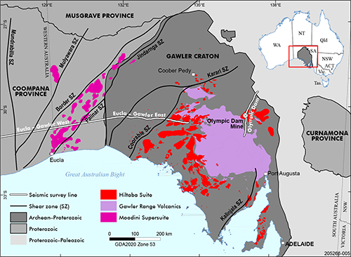
Figure 1 Location of deep seismic reflection profiles across Australia (inset) and selected co-located deep seismic reflection and MT profiles in South Australia discussed in text (white). Major crustal elements, structures and key syn-post tectonic magmatic suites (Curtis and Thiel 2019; Stewart et al. 2013; Wise, Cowley and Fabris 2015; Wise, Pawley and Dutch 2018) are shown. Reprinted from Wise and Thiel (in press, fig. 1) under Creative Commons licence CC BY-NC-ND 4.0.
In the Gawler Craton, the widespread c. 1595–1575 Ma Hiltaba Suite and Gawler Range Volcanics were part of a mantle-derived magmatic event and siliceous large igneous province (Wade et al. 2019) that intruded into, and extruded onto the central, southern, eastern and western Gawler Craton (Fig. 1), and was associated with regional deformation in the western and northern Gawler Craton (Hand, Reid and Jagodzinski 2007). This event was also associated with significant metallogenesis, and the formation of the Olympic Dam, Prominent Hill and Carrapateena IOCG deposits in the eastern Gawler Craton (Reid 2019), and gold-only deposits in the central Gawler Craton (Hand, Reid and Jagodzinski 2007; Skirrow et al. 2007).
In the Coompana Province, the major tectonomagmatic event was associated with emplacement of the c. 1200–1140 Ma Moodini Supersuite (Fig. 1), which represents part of a thermal event that affected regions between the Gawler, Yilgarn and North Australian cratons (Dutch et al. 2018; Spaggiari and Smithies 2015; Kirkland et al. 2017; Wise, Cowley and Fabris 2015; Wise et al. 2018). In the eastern Coompana Province, the Moodini Supersuite consists largely of isotopically juvenile, high potassium–iron, post-tectonic plutons concentrated in a NE–SW-trending belt at a low angle to the regional grain (Dutch et al. 2018; Wise, Pawley and Dutch 2018) where it intersects the Eucla–Gawler profile (Fig. 1).
Results
Seismic and MT profiles characterise the acoustic and electrical properties of the crust and upper mantle. Typically, seismic reflection profiles have been used to image the geometries of discrete crustal blocks and faults or shear zones throughout the crust, and lithostratigraphic packages in the upper crust. Magnetotelluric profiles have been used to provide information on resistivity contrasts, typically associated with upper crustal sediments, shear zones and fluid pathways.
Below we show that similar physiochemical processes can be mapped with both techniques, and serve as a powerful tool in interpreting the locations of, and controls on, zones of fossil melt or fluid flux.
Profile examples
Eucla–Gawler (seismic line 13GA-EG1)
The Eucla–Gawler collocated seismic and MT profile extends from central South Australia across the border with Western Australia (Dutch, Pawley and Wise 2015). Reflection seismic and 5 km spaced broadband MT surveys were acquired along the transcontinental railway, providing part of an east–west transect imaging the crustal architecture across the margins of, and in-between, the Gawler and Yilgarn cratons. Given competing geo-electric strike directions in MT data between broad crustal sections of the ~800 km long profile (Thiel, Wise and Duan 2015), 2D modelling was conducted in two suitable sections (Fig. 1), which we hereby refer to as Eucla–Gawler East (Fig. 2a) and Eucla–Gawler West (Fig. 2b). At the first order, these two sections correspond to the Gawler Craton and its western margin, and the Coompana Province, respectively.
The reader is referred to Reid and Dutch (2015) for a review of the geology of the western Gawler Craton, and Doublier et al. (2015), Dutch et al. (2015) and Murdie et al. (2017) for interpretation of the seismic section, while the Coompana Province interpretation is detailed by Pawley et al. (2018) and the geology by Dutch et al. (2018).
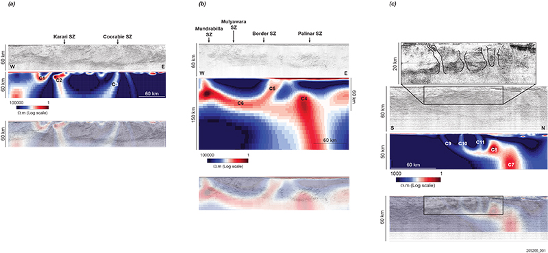
Broadly, the Eucla–Gawler East profile contains a three-layered crust, with a weakly reflective middle crust between highly reflective upper and lower crustal regions (Doublier et al. 2015). West-dipping listric shear zones extend from the surface to offset the Moho. Corresponding to the surface location of several of these shear zones (eg the Karari and Coorabie shear zones; Figs 1, 2a; Doublier et al. 2015) are steeply dipping zones of anomalous conductivity (C2, C3; Fig. 2a), whereas conductive region C1 coincides with the location of the magnetite-rich Moondrah Gneiss (Thiel, Wise and Duan 2015).
The Eucla–Gawler West profile is less structurally complex. A thicker succession of sedimentary basins overlies a generally weakly reflective middle to upper crustal column (Fig. 2b). A highly reflective lower crustal package shallows to the west (Fig. 2b; Pawley et al. 2018). The resistivity structure in Eucla–Gawler West generally displays a three-layer distribution in the subsurface (Thiel, Wise and Duan 2015, 2018). In the top 1 km, sedimentary cover is electrically conductive and underlain by a resistive middle to upper crust. A conductive upper mantle (C4, C6; Fig. 2b) sits beneath the seismic Moho (identified as the deepest coherent reflector), with subvertical conductors extending upward through the crust (eg C4; Fig. 2b).
Figure 2 Co-located seismic (13GA-EG1) and MT profiles. Reprinted from Wise and Thiel (in press, figs 2–4) under Creative Commons licence CC BY-NC-ND 4.0.
(a) Eucla–Gawler East co-located seismic (13GA-EG1) and MT profiles (after Holzschuh 2015; Thiel, Wise and Duan 2015, 2018), with the surface location of selected major shear zones. Conductor C1 is associated with a region of high variability in seismic character, west of the Karari Shear Zone (C2, and Fig. 1). While the Coorabie Shear Zone (C3 and Fig. 1) near-surface expressions in seismic and MT are coincident, it displays a large discrepancy between a shallow, west-dipping zone in the seismic imagery (see Doublier et al. 2015 for the full interpretation), and a steep, west-dipping conductive zone. There exists coincidence between the high-conductivity zones C2 and C3 and a break in the higher reflectivity in the lower crust.
(b) Eucla–Gawler West co-located seismic (13GA-EG1) and MT profiles (after Dutch et al. 2016; Pawley et al. 2018; Thiel, Dentith et al. 2016; Thiel, Wise and Duan 2018). Major west-dipping shear zones are marked at their surface intercept (Fig. 1). The Coompana Province is dominated by a highly reflective middle crust between 15 km and 40 km. Beneath, the lower crust has a low-reflectivity, high-conductivity character (C6). The continuous lower crustal conductor extends to the surface (C5) where granitic basement subcrops beneath the extensive sedimentary cover (Wise, Pawley and Dutch 2015).
(c) Olympic Dam co-located seismic (03GA-OD1) and MT profiles. First panel: Enlarged view of a reprocessed section of seismic data with interpreted fluid pathways from the middle crust (after Wise et al. 2015). Second panel: Original processed seismic image (after Jones, Johnstone and Goleby 2005). Third panel: 2D resistivity model across the same profile (Heinson et al. 2018). Fourth panel: Resistivity model overlain on the seismic image.
Olympic Dam (seismic line 03GA-OD1)
Of the two orthogonal seismic lines acquired across the Olympic Dam deposit, the 200 km north–south profile has been the focus of recent seismic and MT studies (Wise et al. 2015; Heinson et al. 2018). A variation in seismic processing methodology – partially preserved amplitude processing – revealed greater reflectivity contrasts in the upper crust and permitted interpretation of steeply dipping structures, interpreted to reflect possible fossil fluid pathways (Wise et al. 2015). Infilling an original site spacing of 5–10 km, recent higher frequency and higher resolution MT data acquisition shows similarly located zones of high conductivity in the upper crust (C9–11; Fig. 2), stemming from an extremely conductive middle crustal zone (C8; Fig. 2) and mantle connection (C7; Fig. 2; Heinson, Direen and Gill 2006; Heinson et al. 2018).
Discussion
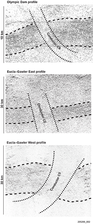
Figure 3 Location of crustal conductors C2, C5, C9 and the spatial coincidence with zones of reduced reflectivity cross-cutting flat-lying, mid-lower crustal reflective packages, indicating the process causing enhanced conductivity is related to that causing reduced reflectivity. Reprinted from Wise and Thiel (in press, fig. 5) under Creative Commons licence CC BY-NC-ND 4.0.
Focusing on spatial associations of seismic and resistivity character that overprint earlier crustal fabrics, it is evident that conductive MT features correspond better to variation in seismic reflectivity rather than discrete reflectors. Particularly apparent is the association between low-reflectivity zones and steeply dipping conductors (Fig. 3). It is this relationship that we discuss further.
What the joint geophysical signatures mean
In a seismic section, a pre-existing fabric would be imaged as a series of shallowly dipping to moderately inclined reflectors. While there are a number of reasons why there could be low reflectivity in a particular piece of crust – such as unfavourable near-surface conditions, crooked lines, acquisition problems – the spatial link with the results from a different technique and physical property renders this unlikely, and the cause is assumed to be geological, and therefore a modification of a pre-existing fabric.
As there is a spatial link between the location of low-reflectivity, high-conductivity zones and major magmatic suites such as the A-type granites in the Olympic Domain (Fig. 1; Skirrow et al. 2007; Reid, Jourdan and Jagodzinski 2017) and the Moodini Supersuite in the Coompana Province (Fig. 1; Dutch et al. 2018; Wise, Pawley and Dutch 2015), we suggest that the process leading to the high conductivity and low reflectivity also has a magmatic–hydrothermal origin.
Fluid (hydrous or as melt) flux provides a convenient mechanism with which to destroy a pre-existing rock fabric. Interconnected, channelised flow networks (eg Daczko et al. 2016) are likely candidates for melt migration mechanisms reducing the acoustic impedance of a rock package, lowering seismic reflectivity (eg Drummond et al. 2006; Heinson, Direen and Gill 2006; Spaggiari and Tyler 2015; Heinson et al. 2018). Where such a fluid was capable of reacting with the host rock, products with an electrical signature may be left behind, leading to enhanced conductivity in these modified regions.
Experimental work by Li, Jiang and Yang (2017) has discussed the role of fluorine enrichment in silicates as a mechanism for producing high conductivities. Xing et al. (2019) also link the role of fluorine in IOCG systems in promoting porosity creation by increasing silica solubility, providing a carrying agent for uranium and rare earth elements, and therefore increasing fluid pathway connectivity and metal transport capacity.
Given fluorine enrichment at Olympic Dam (McPhie et al. 2011; Xing et al. 2019), as well as fluorine-rich magmatic fluid alteration products (eg sericite–chlorite–fluorite) in the Coompana Province (Dutch et al. 2018), migration of fluorine-enriched magmas and associated hydrothermal fluids serves as a convenient mechanism to produce the observed seismic and electrical responses.
Geological controls on fluid migration
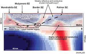
Figure 4 Profile 13GA-EG1, Eucla–Gawler West. Melt transfer pathways imaged as conductive and weakly reflective pathways in the crust. The region of flat-lying reflectors at the base of the crust coinciding with a mantle-derived conductor may indicate an underplate. Reprinted from Wise and Thiel (in press, fig. 6 under Creative Commons licence CC BY-NC-ND 4.0.
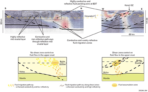
One clear observation from the examples discussed is the coincidence between the location of conductors and offsets in the Moho. An inference from this observation could be that the intersection of crustal-scale structures and the Moho provides a ‘path of least resistance’ for upward-moving melts/fluids to enter the crust (Figs 4, 5).
Defining the controls on melt and fluid ascent through the crustal column however is a key step in the practical targeting of where the near-surface expressions of these processes may be expected. For example, if melt or fluids ascended along shallowly dipping structures, then they would end up at the surface many lateral kilometres away from where they transgressed the Moho boundary. We discuss the controls on ascent processes as follows.
Lower crust
We interpret that melts are focused into the crust by major crustal-scale structures (Figs 4, 5), but may not be dominantly channelled along them in the lower crust. Conductive and non-reflective pathways extend from the upper mantle into the mid crust following trajectories much more steeply dipping than listric crustal-scale shear zones obvious in seismic imagery. This observation has profound implications for the relevance of targeting the surface location of crustal-scale structures for magmatic-associated mineral systems. The examples shown here suggest that the hanging-wall of such structures, above where they intersect the Moho, may better control the location of mantle-derived melts (Figs 4, 5).
Middle to upper crust
Figure 5 Top: Partially interpreted seismic profiles with 2D resistivity models overlain. Mantle-sourced fluid pathways characterised by a reduction in reflectivity and enhanced conductivity overprint earlier fabrics. Interpreted zones of fluid accumulation at the brittle–ductile transition (BDT) are identified as highly conductive regions associated with an increase in reflectivity. The location and geometry of fluid pathways is controlled by shear zones above the BDT in the Eucla–Gawler East profile (right), while evidence is lacking for upper-crustal shear control in the Olympic Dam profile (left). Bottom: Schematic model depicting pathways of fluid flow and zones of accumulation. Reprinted from Wise and Thiel (in press, fig. 7) under Creative Commons licence CC BY-NC-ND 4.0.
Narrow conductive zones are present stemming from a highly conductive middle crustal region in both the Olympic Dam and Eucla–Gawler East profiles (Figs 2, 5). The highly conductive middle crustal zones are interpreted to represent fluid accumulation at the rheological contrast associated with the brittle–ductile transition (Thiel, Soeffky et al. 2016). Above the brittle–ductile transition, in the brittle domain of the upper crust, conductive features are discrete and narrow (2–10 km wide). The geometry of these features varies between subvertical associated with zones of low seismic reflectivity (Olympic Dam profile; C9–11; Figs 2, 5), and shallowly dipping associated with a shear zone interpreted from seismic imagery (Karari Shear Zone, C2; Figs 1, 2, 5). The geometric differences are attributed to the geodynamic regime at the time of fluid movement. Compressive tectonism in the western Gawler Craton (Eucla–Gawler East, eg Dutch et al. 2015; Dutch and Hand 2009), may have focused fluid flow into inclined syn-magmatic shear zones (eg Robertson et al. 2015), whereas there is less evidence for compressive tectonism synchronous with upward-moving melt or fluid in the Olympic Dam region (Hayward and Skirrow 2010).
In the Eucla–Gawler West examples, there is no obvious accumulation of conductive material in the middle crust, perhaps suggesting that there was an insufficient rheological contrast at the time of melt migration. Elevated geothermal gradients were likely during the emplacement of the regionally significant Moodini Supersuite (Wise et al. 2018), and would serve to reduce the effect of rheological boundaries in the crust.
Conclusion
Mapping the imprints of fossil melt and fluid flow events using two geophysical techniques, and therefore two methods of mapping physical property changes, has enabled interpretation as to the movement mechanisms, controls on location and composition of those events. Reactive melt and fluid flow is proposed to produce the electrical and seismic response. This modification of existing rock packages occurs at a range of scales and is manifest differently according to the geodynamic regime at the time and crustal level (rheology).
To summarise the interpretation from the examples used here (Figs 4, 5): melt or fluid derived from the lithosphere is focused into the crust where a crustal-scale structure intersects the Moho, before ascending subvertically through interconnected networks in the lower crust. If a sufficient rheological boundary is present in the middle crust, fluid accumulation will occur, before being focused in the brittle upper crust. Structures active in the upper crust may focus fluids if the orientation is favourable, or, depending upon the variation in regional stress field, fluid pathways may develop that do not obviously follow pre-existing structure (eg beneath Olympic Dam profile).
A key point from this work is that major low-angle structures do not focus the migration of melt and fluids through the lower crust, rather migration occurs through networks in the hanging-wall (Wise and Thiel in press). This point is an important learning for mineral exploration programs targeting mantle-derived fluids, as the hanging-wall of crustal-scale structures represents a favoured search-space (eg Hronsky and Kreuzer 2019).
Acknowledgements
We are grateful to many geoscientists from the Geological Surveys of South Australia and Western Australia as well as Geoscience Australia for discussions surrounding the interpretation of these datasets, as well as for their roles in data acquisition.
References
Curtis S and Thiel S 2019. Identifying lithospheric boundaries using magnetotellurics and Nd isotope geochemistry: an example from the Gawler Craton, Australia. Precambrian Research 320:403–423.
Daczko N, Piazolo S, Meek U, Stuart C and Elliott V 2016. Hornblendite delineates zones of mass transfer through the lower crust. Scientific Reports 6:31369.
Drummond B, Lyons P, Goleby B and Jones L 2006. Constraining models of the tectonic setting of the giant Olympic Dam iron oxide-copper-gold deposit, South Australia, using deep seismic reflection data. Tectonophysics 420:91–103.
Hand M, Reid A and Jagodzinski L 2007. Tectonic framework and evolution of the Gawler Craton, southern Australia. Economic Geology 102(8):1377–1395.
Hayward N and Skirrow R 2010. Geodynamic setting and controls on iron oxide Cu-Au (U) ore in the Gawler Craton, South Australia. In T Porter ed., Hydrothermal iron oxide copper-gold and related deposits: a global perspective, v. 3 - Advances in the understanding of IOCG deposits, ch. 2. PGC Publishing, Adelaide, pp. 9–31.
Heinson G, Didana Y, Soeffky P, Thiel S and Wise T 2018. The crustal geophysical signature of a world-class mineral system. Scientific Reports 8(1).
Heinson G, Direen N and Gill R 2006. Magnetotelluric evidence for a deep-crustal mineralizing system beneath the Olympic Dam iron oxide copper-gold deposit, southern Australia. Geology 34:573–576.
Hronsky JMA and Kreuzer OP 2019. Applying spatial prospectivity mapping to exploration targeting: fundamental practical issues and suggested solutions for the future. Ore Geology Reviews 107:647–653.
Jones J, Johnstone D and Goleby B 2005. Seismic acquisition and processing - 2003 Gawler Craton seismic reflection survey (L163). In P Lyons and BR Goleby, The 2003 Gawler Craton Seismic Survey: notes from the Seismic Workshop held at Gawler Craton State of Play 2004, Record 2005/019. Geoscience Australia, Canberra, pp. 35–47.
Li Y, Jiang H and Yang X 2017. Fluorine follows water: effect on electrical conductivity of silicate minerals by experimental constraints from phlogopite. Geochimica et Cosmochimica Acta 217:16–27.
McPhie J, Kamenetsky V, Allen S, Ehrig K, Agangi A and Bath A 2011. The fluorine link between a supergiant ore deposit and a silicic large igneous province. Geology 9(11):1003–1006.
Reid A, Jourdan F and Jagodzinski E 2017. Mesoproterozoic fluid events affecting Archean crust in the northern Olympic Cu-Au Province, Gawler Craton: insights from 40Ar/39Ar thermochronology. Australian Journal of Earth Sciences 64(1):103–119.
Robertson K, Taylor D, Thiel S and Heinson G 2015. Magnetotelluric evidence for serpentinisation in a Cambrian subduction zone beneath the Delamerian Orogen, southeast Australia. Gondwana Research 28(2):601–611.
Skirrow RG, Bastrakov EN, Barovich K, Fraser GL, Creaser RA, Fanning CM, Raymond OL and Davidson GJ 2007. Timing of iron oxide Cu-Au-(U) hydrothermal activity and Nd Isotope constraints on metal sources in the Gawler Craton, South Australia. Economic Geology 102(8):1441–1470.
Spaggiari CV and Smithies RH comps 2015. Eucla basement stratigraphic drilling results release workshop: extended abstracts, Record 2015/10. Geological Survey of Western Australia, Perth.
Spaggiari CV and Tyler I comps 2015. Albany-Fraser Orogen seismic and magnetotelluric (MT) workshop 2014: extended abstracts, Record 2014/6. Geological Survey of Western Australia, Perth.
Stewart A, Raymond O, Totterdell J, Zhang W and Gallagher R 2013. Australian geological provinces, GIS dataset. 2013.01 edn. Geoscience Australia, Canberra.
Thiel S, Soeffky P, Krieger L, Regenauer-Lieb K, Peacock J and Heinson G 2016. Conductivity response to intraplate deformation: evidence for metamorphic devolatilization and crustal-scale fluid focusing. Geophysical Research Letters 43:11,236–11,244.
Wade CE, Payne JL, Barovich KM and Reid AJ 2019. Heterogeneity of the sub-continental lithospheric mantle and ‘non-juvenile’ mantle additions to a Proterozoic silicic large igneous province. Lithos 340-341:87–107.
Wise T and Thiel S in press. Proterozoic tectonothermal processes imaged with magnetotellurics and seismic reflection in southern Australia. Geoscience Frontiers. https://doi.org/10.1016/j.gsf.2019.09.006 (Open access)
Xing Y, Etschmann B, Liu W, Mei Y, Shvarov Y, Testemale D, Tomkins A and Brugger J 2019. The role of fluorine in hydrothermal mobilization and transportation of Fe, U and REE and the formation of IOCG deposits. Chemical Geology 504:158–176.


