
On this page
- Map menu, Spatial search
- Main menu, Quick search
- Main menu, Spatial search
- Main menu, Activate map layers
- Drillhole advanced search
- Drillhole search results
- Drillhole details
- Core inspection
SARIG offers two ways to search and access drillhole data.
1. Map Menu, Spatial Search
Click the Spatial Search icon in the map menu at the bottom of screen.

Select Mineral drillholes from the data source drop-down box and draw an area on the SARIG map. Results from the search will appear in the bottom right corner of the screen, with an option to download to a CSV (Excel) file.
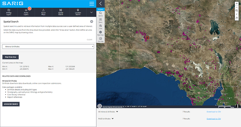
Click on the Advanced Search button to go to an Advanced Search form (shown further down this page).
2. Main Menu, Geoscientific Data, Drilling and Online Core Library

From the Main Menu select Geoscientific Data. Under Drilling and Online Core Library select either Quick Search, Spatial Search or the Activate Map Layers option.
Quick Search
A search form with the most common drillhole searching criteria. This form searches the entire SA Geodata drillhole database.
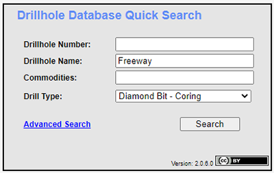
Enter the search criteria and click Search. The Drillhole Search Results screen will open. Database wildcards are not required and where possible, drop-down list and auto fill capabilities are provided.
For more detailed searching criteria click the Advanced Search blue hyperlink located at the bottom of the quick search form.
SA Geodata is the Government of South Australia's primary corporate geoscientific data repository and captures mineral exploration data derived by industry reporting requirements and government exploration programs since the 1850s.
Note: Drillhole map layers need to be turned on to access SA Geodata drillhole data via SARIG.
Spatial Search
When selected, the mineral and collaborative initiative drillholes layers will be active. Draw an area of interest on the SARIG map. Results from the search will appear in the bottom right corner of the screen, with an option to download to a CSV (Excel) file. Click on the Advanced Search button to go to an Advanced Search form (shown further down this page).

Activate Map Layers
When selected will display all available drillhole map layers on the SARIG map.
Note: The Identify tool and Database Drillhole Advanced Search require the user to draw a defined area of interest (box drawn on the map). Due to large datasets the user-defined area is restricted to the equivalent of 2 degrees longitude x 2 degrees latitude.
Drillhole Advanced Search
The Drillhole Advanced Search allows users to directly search SA Geodata using the filter options provided.
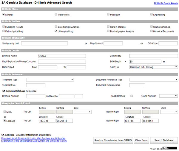
Once all required options are entered click the Search Database button to return all Drillholes Search Results (see below).
Database wildcards are not required. Where possible drop-down list and auto fill capabilities are provided.
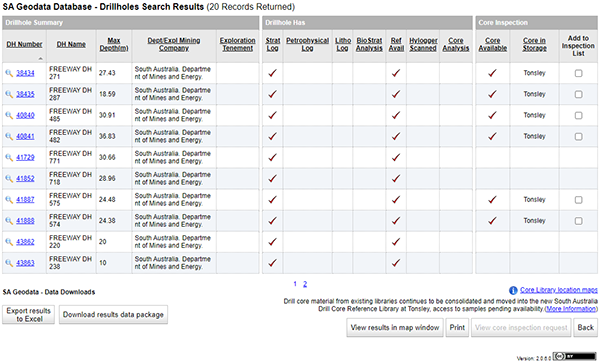
Drillholes Search Results
The Drillholes Search Results is a list of all drillholes available in the area of interest, filtered by options provided in the advanced search form.
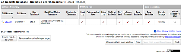
The results include:
- Drillhole Summary. Click the magnifying glass or the hyperlinked drillhole number to view the drillhole details including location, stratigraphy, lithology, core details, spectral scanning and reference information.
- Drillhole Has. Indicates types of drillhole data stored in SA Geodata.
- Core Inspection. Indicates available core. Bookings to inspect core can be made here.
Note: Click on the drillholes search results headings to sort different fields. A grey arrow will appear below the heading to indicate which field is being sorted.
Drillhole Details
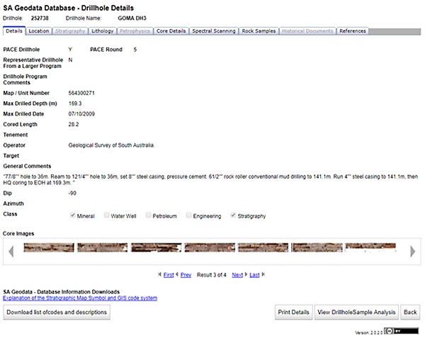
The Drillhole Details screen shows tabs displaying data captured in SA Geodata:
- Details: collar, survey and general drillhole details.
- Location: drillhole coordinates and map sheet data.
- Stratigraphy: drilling stratigraphy interval logs.
- Lithology: drilling lithology interval logs and description. May contain more than one log. Click Select (blue hyperlink) to view log.
- Core Details: core intervals, location of core, previous inspection and sample record flags.
- Spectral Scanning: HyLogger images and results.
- Rock Samples: links to Rock Sample database.
- References: links to Publications database where drillhole was originally reported.
The Drillhole Details screen also provides SA Geodata - Database Information Downloads. This includes an Explanation of the Stratigraphic Map Symbol and GIS code system document. Stratigraphic units are used consistently across the state’s geological maps and this document explains the hierarchical sequence of the GIS Code and Map Symbol.
Core Inspection
Inspections of available core can be booked from the Drillhole Search Results screen.
Step 1. Tick the Add to Inspection List check box for the required drillhole. The Core Inspection Intervals pop-up form will display.
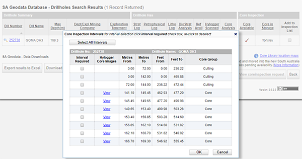
Step 2. The Core inspection Intervals form displays the drillhole intervals and, where available, the option to view HyLogger core images. Click the Interval Required check boxes or Select All Intervals. When selections are complete, click OK.
Step 3. Users are returned the Drillhole Search Results screen where more drillholes can be added to the inspection list. When selection is complete, click View core inspection request.
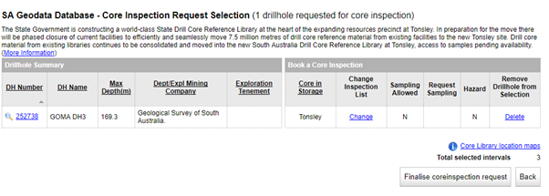
Step 4. When core selection is completed click Finalise core inspection request. A Submit Core Inspection form will appear.
Step 5. Complete details marked with an asterisk* and Submit.
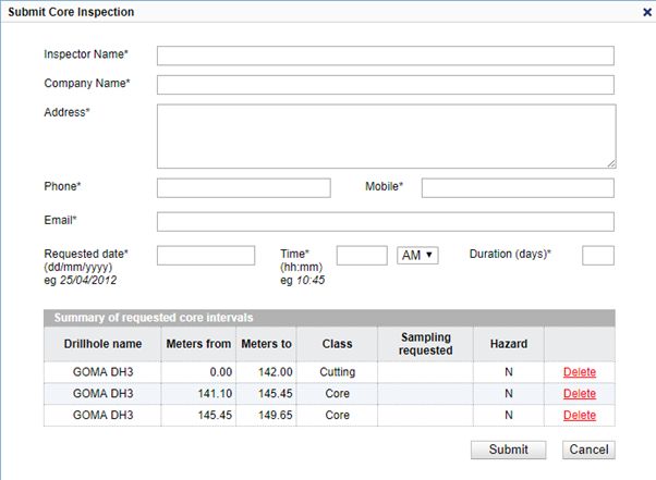
Note: Forty-eight (48) hours notice is usually required to reserve inspection space and allow time for the layout of sample trays.
Step 6. A confirmation pop-up will display detailing the core inspection reference number and core library contact number. Click the OK button.
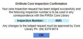
Once the OK button is clicked the user will receive a summary of the core inspection request.
Export and download results
Export results to Excel. Click to download the drillhole search results table.
Download results data package. Click to select a package type. Downloading is available for up to 2,500 records. Refine the searching criteria if this number has been exceeded. Select a download package and click Download.
Contact information
Drillhole data
Customer Services
Level 4, 11 Waymouth Street
Adelaide, South Australia 5000
+ 61 8 8463 3000
Resources.CustomerServices@sa.gov.au
Core inspections
5 Tonsley Boulevard
Clovelly Park SA 5042
+61 8 8379 9574
david.groom@sa.gov.au