
New geological features revealed.
The data and report for the Gawler Phase 2 gravity dataset has been released on the South Australian Resources Information Gateway (SARIG). This regional gravity survey contains over 5,500 new gravity observations in central South Australia, covering the region around and between the Challenger gold mine and the Jacinth-Ambrosia mineral sands mine. Measurements were taken every 2 x 2 km over a large grid, with about half of the measurements being part of a detailed 1 x 1 km infill area around the Challenger mine and prospective area to the south.
The gravity data shows hitherto unseen geological features including paleochannels, glacial paths and shear zones (Fig. 1). Combined with other geophysical datasets, a more robust geological history of the area is being constructed by the Geological Survey of South Australia. Data is also being incorporated into the statewide gravity grid (along with other newly released public domain surveys). We anticipate the new state grid will be ready for download in early 2023.
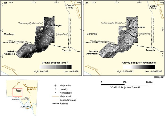
Figure 1 (a) GP2 Bouguer gravity grid. (b) First vertical derivative (1VD). The images display geological features in greater clarity than was available previously.
For assistance, contact DEM.SARIG@sa.gov.au
Background
Conducted under the GP2: next generation minerals system mapping project, the survey is the result of over a year of planning. Land access negotiations with the Antakirinja Matu-Yankunytjatjara Aboriginal Corporation (AMYAC), Far West Coast Aboriginal Corporation (FWCAC) and the Maralinga Tjarutja Council commenced in late 2021. The AMYAC land in the survey area has numerous pastoral leases on it, and the AMYAC board voted to have monitors accompany the gravity survey team. The FWCAC was originally keen for monitors in their portion of the survey, but due to logistical challenges settled on flying over the survey area to identify any potentially sensitive sites. The Maralinga Council voted against the survey being undertaken on their lands resulting in around 400 sites being dropped from the original plan. A request for quote was organised via SA Tenders to select a surveying company to undertake the gravity acquisition in late 2021, and a plan for environmental protection and rehabilitation was approved in mid-2022.
The data were acquired by Daishsat Geodetic Surveyors during August to September 2022. The surveyors used a combination of utility terrain vehicles (UTVs) and a Robinson R44 helicopter to access the proposed sites. The UTVs were used over the AMYAC/pastoral leases portion of the survey, and the helicopter over the FWCAC/Yellabinna Regional Reserve. The Yellabinna Regional Reserve is a protected area of sparsely vegetated red sand dunes necessitating minimal ground disturbance.
– Phil Heath, December 2022