
New map and 3D model assist exploration.
The Geological Survey of South Australia (GSSA) has partnered with CSIRO to develop a robust model and understanding of the basin architecture of the Stuart Shelf to aid exploration for sedimentary copper. Two recent releases from the Sedimentary Copper Mineral Systems of the Stuart Shelf project are now available for download and provide assistance to those interested in sedimentary copper in the state.
3D models of stratigraphic surfaces on the Stuart Shelf
Fundamental to this project is to map the distribution of sedimentary units across the Stuart Shelf and understand the relationship between sediment-hosted copper mineralisation and key stratigraphic surfaces, basin architecture and potential metal sources. Important stratigraphic surfaces have been modelled in 3D for an area of interest within the Stuart Shelf. These include:
- top of the Pandurra Formation – potential copper source
- top of Beda Basalt – potential copper source
- top of Tapley Hill Formation – potential host unit
- base of Whyalla Sandstone – a major unconformity to known stratabound sediment-hosted copper deposits on the Stuart Shelf.
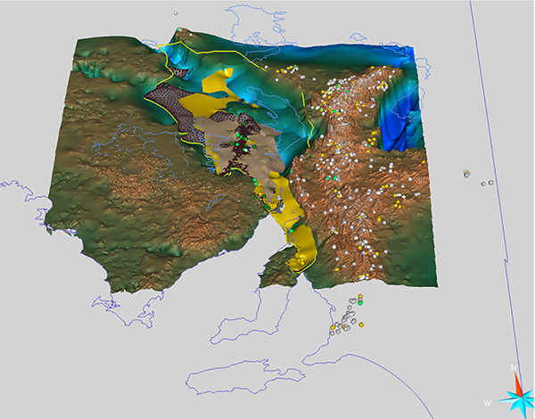
Each surface has been constructed from 1,504 drillholes with stratigraphic logs that have encountered the relevant stratigraphic units (extracted from SA Geodata) and outcrops based on the 1:100,000 scale surface geology (in SARIG). Airborne electromagnetic flight lines were also used for the Pandurra Formation surface.
All surfaces have been constructed in SKUA-GOCAD 19 and are available in both native GOCAD and AutoCAD .dxf file formats. AutoCAD files can be opened in a large variety of 3D viewing applications; however, the free Geoscience Analyst 3D viewer can open and interrogate native GOCAD file formats and is recommended.
Future updates to these surfaces are planned and will include additional constraints based on geophysical interpretation.
Access the Stuart Shelf sedimentary copper 3D model
Sediment-hosted copper occurrence map
The South Australian Neoproterozoic sediment-hosted copper occurrences map displays a distinct category of the state’s copper occurrences and demonstrates that well over one-third of the state’s copper occurrences are hosted in Neoproterozoic sediments. In total, 662 occurrences have been identified and further classified as dominantly:
- stratabound, showing characteristics of the sediment-hosted stratabound copper model
- structurally controlled, or those where secondary processes mask the primary control.
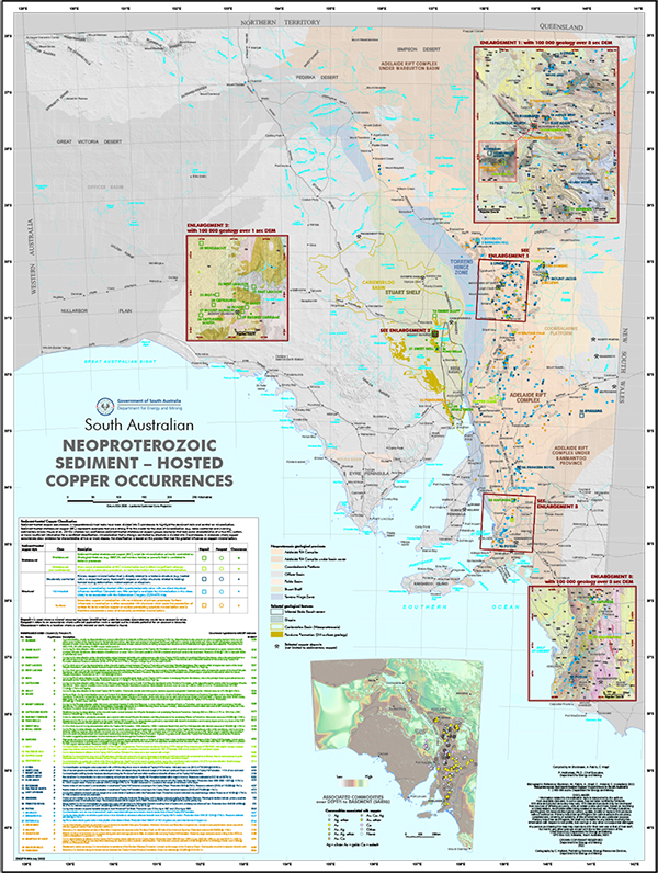
The majority of occurrences are located within the Adelaide Rift Complex, Torrens Hinge Zone and Stuart Shelf, and include the historical copper mines of Kapunda, Blinman and Mount Gunson. A summary description of the 40 Neoproterozoic sediment-hosted deposits and prospects are provided.
For the first time in the GSSA’s commodity map series, this PDF map is interactive and enables the user to identify occurrences which are linked to the Mines and Deposits (MINDEP) database (in SARIG) containing associated information.
An inset map displays the commodities associated with copper mineralisation and highlights a strong association of occurrences with gold within folded portions of the northern and southern Adelaide Rift Complex.
Download the South Australian sediment-hosted copper occurrences map (PDF 11 MB)
More information on the Sedimentary Copper Mineral Systems of the Stuart Shelf project
– Carmen Krapf, Adrian Fabris, George Gouthas and Mitchell Bockmann, October 2022