Carmen Krapf, Mark Pawley, Mario Werner, Rian Dutch, Jonathan Irvine, Phil Heath and Steve Hill
Geological Survey of South Australia, Department of the Premier and Cabinet
Download this article as a PDF (4.3 MB); cite as MESA Journal 84, pages 4–9
Introduction
The surface geology for the ALCURRA 1:100,000 scale map sheet has been remapped and updated and is now available as a digital map sheet via SARIG (Fig. 1). ALCURRA is located in the central northern region of South Australia, near the eastern outcrop margin of the Musgrave Province.
The Musgrave Province, located in central Australia straddling the South Australia, Western Australia and Northern Territory borders, is arguably one of the least understood Proterozoic terranes in Australia. It is located in a key position between the three Paleoproterozoic cratonic blocks that form proto-Australia. It is highly prospective, particularly for magmatic sulfide deposits associated with the Giles Complex intrusives, but is underexplored due to remoteness and access restrictions.
The South Australian part of the Musgrave Province was previously mapped at reconnaissance level during the 1950s to 1970s. No significant mapping was undertaken to the 2000s and only one 1:100,000 map sheet was updated (EATERINGINNA; Conor 2004). In 2011 the Geological Survey of South Australia revitalised the mapping program for the eastern Musgrave Province through the PACE Exploration program ‘1.1 Pathways to Prospectivity – New Frontier Mapping’. The first of three maps was published in 2012 (TIEYON; Dutch et al. 2013) and this is now followed by ALCURRA (Krapf et al. 2017) and in the near future by AGNES CREEK.
ALCURRA is bounded by latitudes 26°00’S and 26°30’S and longitudes 133°00’E and 133°30’E, and forms the northeastern 1:100,000 map of the 1:250,000 ALBERGA (SG 53-9) map.
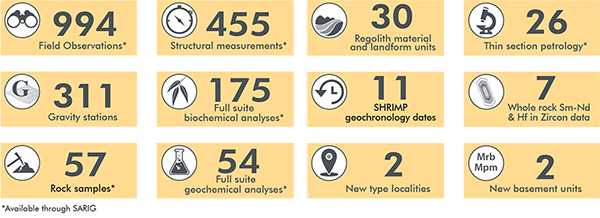
Detailed basement, structural and regolith mapping was carried out in combination with remote-sensing and orthophoto interpretation utilising high-resolution enhanced orthoimagery and digital elevation model, total magnetic intensity and gravity data. Both the regolith and outcropping geology are represented on the new map.
Map peripherals include total magnetic intensity and Bouguer gravity anomaly images, digital elevation model imagery (1 s SRTM digital terrain model) with drillhole locations, reliability diagram showing field observation sites, inset of the Mesoproterozoic solid geology interpretation and a customised legend with 46 lithological units (the previous map edition had only 11 lithological units). The new digital line work is being integrated into the 100K Geology layer in SARIG.
New data acquired
Updates to the geology
Our understanding of outcrop occurrences of the Birksgate Complex, Pitjantjatjara Supersuite, mafic dyke suites and Eromanga Basin sedimentary rocks has been greatly refined and many new outcrops have been discovered and recorded (Figs 2–4).

Figure 2 Northern side of Wallaby Rock showing the gently west-dipping Birksgate Complex gneiss megaraft within Pitjantjatjara Supersuite granite. In the central-eastern part of the photo, the gneiss megaraft is split into an upper and lower layer by a lenticular granite intrusion. (Photo 415775)
More lithological subdivisions, increased geochemical, isotopic and geochronological control, and greater structural knowledge of the area has been achieved.
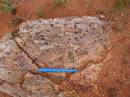
Figure 3 Example of the newly defined Branson Well Quartzite which is primarily composed of quartz with minor feldspar, sillimanite, magnetite and garnet. The quartzites are pale grey and medium- to coarse-grained with a poor, variably developed, centimetre-scale layering (likely bedding) defined by grain size variation. (Photo 415776)
Whereas the Mesoproterozoic Birksgate Complex was undivided on earlier versions of ALCURRA, the new version contains seven lithology units for these high-grade basement rocks. This includes two spatially distinct metasedimentary rock packages, comprising quartzites and aluminous gneisses (after pelites), which locally form marker units that highlight the structural evolution of the area (Pawley et al. 2015). The previously undivided Pitjantjatjara Supersuite has been subdivided into three map units.
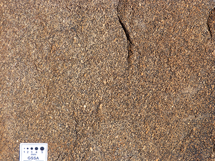
Figure 4 Example of the newly defined Mundy Dam Microgranite which is fine- to medium-grained, inequigranular (locally porphyritic), massive to foliated, and composed of feldspar, quartz and biotite. The quartz forms equant, irregular grains in the more massive parts, and recrystallised ribbons that are generally 1 mm wide and <5 mm long. (Photo 415777)
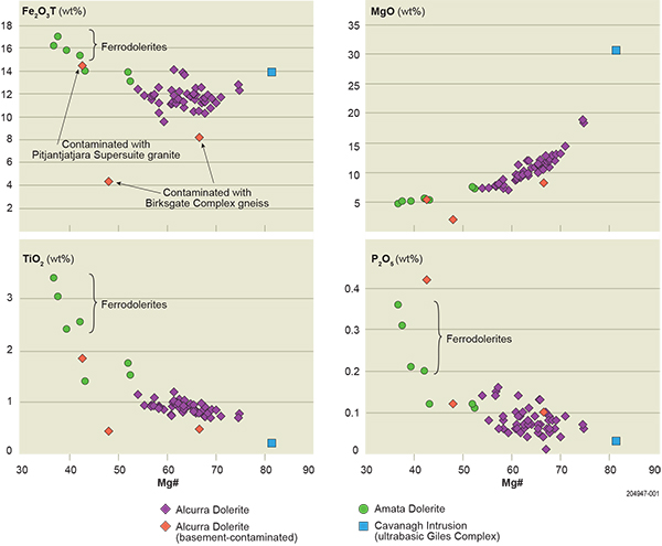
Two geochemically distinct dolerite suites have been recognised: the Mesoproterozoic high La/Nb Alcurra Dolerite, and the Neoproterozoic low La/Nb Amata Dolerite (equivalent to the Gairdner Dolerite; Fig. 5; Werner et al. 2014, 2015). The Alcurra Dolerite forms a high-density dyke swarm that straddles the Northern Territory border along the northern margin of ALCURRA. Dykes of this suite also occur to the south, but they are more dispersed. The Amata Dolerite forms dispersed dykes that mainly outcrop in the southern part of the area. Outcrops of the Alcurra Dolerite dyke swarm in the northern part of the map sheet have been mapped in great detail for the first time. A comprehensive geochemical dataset is now available for the type area of the Alcurra Dolerite (Werner et al. 2015).
Figure 5 Binary variation diagrams of Fe2O3T, MgO, TiO2, and P2O5 vs Mg number in the Alcurra and Amata dolerites. Labelling of ferrodolerites is in accordance with the definition of ferrobasalts by McBirney and Williams (1969).
ALCURRA forms the northernmost part of the present day western outcrop margin of the Eromanga Basin in South Australia. Isolated erosional remnants of shaly and sandy rocks of inferred Jurassic–Cretaceous age have been reported previously within AGNES CREEK and ALCURRA areas (Coats 1962), indicating the original larger extent of the Eromanga Basin. Outcrops of Algebuckina Sandstone, which forms part of the basal Eromanga Basin sedimentary succession, have been confirmed and new outcrops found.
Understanding the type and thickness of sedimentary cover is critical to exploring for buried deposits and determining the suitability of the cover material as a sampling medium for detecting the mineral footprints of buried deposits. Detailed mapping of transported and in situ regolith materials and associated landforms resulted in the subdivision of 30 Cenozoic units on ALCURRA which can be assigned to 23 different landforms (Fig. 6). These include silcretes, ferricretes, various lag types, source-bordering and longitudinal dunes, various types of sand plains, colluvial sediments, mixed transported regolith materials and calcrete induration. On the adjacent AGNES CREEK map some of the aeolian sand units have been dated for the first time using optical stimulated luminescence (OSL). The previously inferred Holocene age has been resolved to be of Late Pleistocene with ages between 76 to 24 ka (Krapf et al. 2014).
Given the extensive deep weathering of basement lithologies in the eastern Musgrave Province, the surface geology has been mapped using a system of piggyback codes so that the nature of the subcropping bedrock beneath the regolith is represented. Piggyback symbols have also been used to characterise complex regolith profiles.
In tandem with mapping, gravity measurements were taken at 2 km spacing along roads, farm tracks and fence lines on ALCURRA, AGNES CREEK and TIEYON (Heath 2014). This new data has resulted in better definition of the NNE-trending gravity high that is a feature of the region, and corresponds to the uplifted core of the orogen (Aitken et al. 2009). The survey also highlighted a small gravity bulge off the main ENE-trend that corresponds to a small pluton of Pitjantjatjara Supersuite granite. This pluton also corresponds to a magnetic high. The new gravity data is shown on a peripheral map. Geophysical data collection will continue to be included in future mapping activities.
Figure 6 Examples of two common regolith materials on ALCURRA.
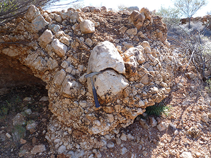
Figure 6a Pedogenic silcrete formed in colluvial scree deposits. (Photo 415778)
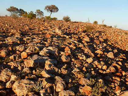
Figure 6b Silcrete lag forming a veneered surface where clasts were derived by let-down lags due to mechanical weathering. (Photo 415779)
Geological summary
Our mapping of ALCURRA shows that the area has a complex geological record with:
- crustal- and lithospheric-scale structures
- multiple reactivations and overprinting events (Musgravian Orogeny, Giles Event, multiple dyke swarms, Petermann Orogeny and ?Alice Springs Orogeny; Pawley et al. 2014)
- presence of different geological provinces (Musgrave basement, Eromanga Basin sedimentary rocks and Hamilton Basin paleochannel sediments)
- intricate regolith material and landform distribution and complex in situ regolith profile development over bedrock
- significant regional alteration
- significant volume of mafic dykes
- delineation of two dolerite suites in the region, including the economically important Alcurra Dolerite suite
- further evidence for 1600 Ma igneous units in the eastern Musgrave Province
- incorporation of local isotopically evolved crust at 1600 Ma that could preclude the need for an external source of evolved crustal input
- evidence for Archean protoliths and reworking of evolved Archean crust indicating a possible Archean basement or crustal slivers within the Musgrave Province.
References
Aitken ARA, Betts PG, Weinberg RF and Gray D 2009. Constrained potential field modelling of the crustal architecture of the Musgrave Province in central Australia: evidence for lithospheric strengthening due to crust-mantle boundary uplift. Journal of Geophysical Research 114:B12405.
Coats RP 1962. The geology of the Alberga 4-mile military sheet, Report of Investigations 22. Geological Survey of South Australia, Adelaide.
McBirney AR and Williams H 1969. Geology and petrology of the Galapagos Islands, Memoirs 118. Geological Society of America.


