David Tonkin
THZ Pty Ltd
Download this article as a PDF (3.1 MB); cite as MESA Journal 89, pages 39–44
Published April 2019
Introduction
Figure 1 Location map showing distribution of the Whyalla Sandstone on the southern Stuart Shelf. Possible Whyalla Sandstone recorded on the northern Stuart Shelf is not shown. Along its eastern margin, in the Torrens Hinge Zone, the Whyalla Sandstone transitions into the Elatina Formation of the Adelaide Geosyncline.
Copper-bearing sandstones were mined near Mount Gunson from the late 19th century. Located ~410 km NNE of Adelaide, the deposits occur within Proterozoic sediments of the Adelaide Geosyncline. Because copper deposits were found at two different elevations, with a vertical separation of 21 m, it was assumed that there were two copper-bearing horizons within the sandstone sequence. In 1966 a petrology investigation distinguished between ‘lithic sandstone’ and ‘red quartzite’ horizons within the Pernatty Grit, separated by the Woocalla Dolomite Member. Recognition that a disconformity separates these two horizons led to the realisation that all the sandstone-hosted copper deposits at Mount Gunson lie at the same stratigraphic level, associated with this disconformity, and not at two stratigraphic levels as previously assumed. A flawed correlation made in 1968 between the ‘lithic sandstone’ and some sediments near Whyalla, led to the formal definition of this horizon as ‘Whyalla Sandstone Member’. When subsequent exploration drilling invalidated this correlation, a new type section for Whyalla Sandstone was nominated; an exposure in the Cattle Grid open cut mine at Mount Gunson (Fig. 1).
This article provides a historical account of the exploration and regional mapping which led to the recognition and definition of the Whyalla Sandstone. Having clarity on the Whyalla Sandstone and its disconformable contact with the Pandurra Formation has helped develop a better understanding of its relationship to the Mount Gunson copper deposits and has provided a focus for new exploration.
Early observations
Figure 2 Subcrop geology map (pre Tregolana Shale time slice) and locality map for the Mount Gunson mines district, showing the principal sandstone-hosted copper deposits and the enigmatic ‘Mystery Workings’.
Observations at the ‘Bornite Workings’, now known as West Lagoon deposit, provided the earliest references to the stratigraphic unit now known as Whyalla Sandstone (Fig. 2). Early investigators described green oxide and black sulfide copper mineralisation forming a matrix in soft and friable ‘leaching sands’, which overlie a hard red quartzite in which minor veinlets of copper sulfide followed joint and bedding planes (Jones 1909; Wainwright 1914). The underlying red quartzite is clearly the unit now known as Pandurra Formation. The reports did not mention the colour of the ‘leaching sands’, but in an excavation made by Austminex Pty Ltd in 1966, I observed a friable red sandstone, lying beneath the surface mud of the lagoon. At first this red sandstone was mistaken for Pandurra Formation. Contemporary percussion drilling intersected sulfide-bearing, friable, red, yellow and grey sandstone beneath the lagoon surface at West Lagoon, also indicating that the leaching sands were in part reddish coloured (Austminex 1967).
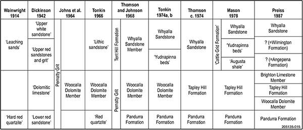
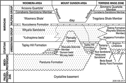
Dickinson (1942) investigated copper deposits in the Main Open Cut area, 2.5 km south of West Lagoon workings. In underground workings beneath the tableland west of the open cut, Dickinson identified an ‘upper white sandstone’ horizon disconformably overlying mineralised ‘upper red sandstones and grit’. These two horizons equate to what are now called the Whyalla Sandstone and Pandurra Formation respectively (Fig. 3).
Dickinson (1953) mistakenly correlated the mineralised Pandurra Formation at Main Open Cut with copper-bearing ‘upper red sandstones and grit’ exposed 600 m to the east in ‘Brennan’s Workings’ (now known as House deposit), where they overlie ‘dolomitic limestone’ and must therefore be red coloured Whyalla Sandstone (Fig. 3). Directly underlying the dolomite Dickinson identified a ‘lower red sandstone’ horizon, which he regarded as ‘indistinguishable lithologically’ from the ‘upper red sandstones and grit’, although this must have been Pandurra Formation. Whilst Dickinson’s ‘upper white sandstone’ can now be recognised as reduced Whyalla Sandstone, he misconstrued the relationships within and between the ‘upper white and red sandstones’, the ‘dolomitic limestone’ and the ‘lower red sandstone’, possibly as the result of relying on colour rather than lithology to correlate sandstone horizons.
At West Lagoon deposit, Dickinson (1953) reported copper oxides and sulfides ‘impregnating soft sandstone’, which disintegrated on exposure. This was clearly mineralised Whyalla Sandstone. Beneath the mineralised soft sandstone was found a ‘hard red quartzite’, carrying copper sulfide in joint and bedding planes only. This was the Pandurra Formation.
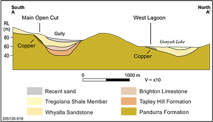
Figure 4 Geological cross-section through Main Open Cut and West Lagoon deposits. The upper surface of the Pandurra Formation is a disconformity (erosional unconformity). Although the copper deposit in the Lagoon lies at a 20 m lower elevation than the Main Open Cut deposit, both are at the same stratigraphic level, associated with the disconformity. The ‘upper white sandstone’ at Main Open Cut and the ‘leaching sands’ at West Lagoon are in fact the same horizon, now known as the Whyalla Sandstone.
Although Dickinson (1953) correctly recognised a disconformity separating the white Whyalla Sandstone from the underlying, mineralised red Pandurra Formation at Main Open Cut, he failed to make a correlation with the West Lagoon deposit, where strongly mineralised, red or multi-coloured Whyalla Sandstone overlies poorly mineralised Pandurra Formation (Fig. 4). This misconception persisted, and until 1966 most investigators believed there were two mineralised horizons within one sandstone sequence; one horizon at lagoon level and the other 70 feet (21 m) higher (King and Australian Mining and Smelting Company 1950; Johns 1965, 1968).
Johns et al. (1964) assigned the sandstones now known as the Whyalla Sandstone and the Pandurra Formation, plus the intervening dolomite horizon, to the newly named Pernatty Grit formation, which Johns (1968) compared to the Elatina Formation, noting the presence at some locations of pebbles possibly derived from the ‘Gawler Range Porphyry’. Johns (1968) cited the drill core section of the Woomera Bore between 239 and 611 m as representative of the Pernatty Grit.
Recognition of the ‘lithic sandstone’
Austminex Pty Ltd in 1966 faced the same conundrum as Dickinson had earlier. An excavation on the eastern shore of Pernatty Lagoon, 1.5 km east of the old Mount Gunson homestead, exposed a dolomitic limestone horizon lying either within a red sandstone horizon or sandwiched between two very similar red sandstone layers. This site was dubbed ‘Mystery Workings’ in recognition of the apparent enigma. Drilling by Austminex immediately north of Main Open Cut had intersected friable white sandstone overlying dolomitic limestone, which in turn overlies red sandstone/quartzite. The exposure in Mystery Workings raised several possibilities: there could be two dolomitic horizons, one within the red sandstone and one separating the red and white sandstone horizons; the dolomitic layer could be transgressive across the stratigraphy; or there could be another explanation (Tonkin 1982).
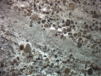
Figure 5 Close-up of Whyalla Sandstone from Cattle Grid mine, showing coarse (1–2 mm), well rounded quartz and lithic grains in a fine grained, angular matrix. Quartz grains are frosted and etched (note the deep embayment in a large quartz grain right of centre at top of photo). (Photo 417755)
A petrographic investigation of red sandstone samples from above and below the dolomitic horizon at Mystery Workings helped to resolve the problem. Dr Owen Singleton from the University of Melbourne compared the two red sandstone horizons and reported that both are mature quartzose sandstones, with a red colouration due to hematite coating the grains (Singleton 1966; Tonkin 1966). The upper unit is characterised by three factors: the marked sphericity of the coarser grains (~2 mm), especially the quartz; the abundance of red lithic grains, probably derived from porphyritic felsic volcanics; and a finer fraction (~0.1 mm) composed of angular quartz and clay (Fig. 5). Singleton labelled this upper unit ‘lithic sandstone’. The lower red sandstone is characterised by its persistent red colour (except in zones of white Liesegang banding) and by pervasive silicification, due to syntaxial quartz overgrowths. Singleton labelled this lower unit ‘red quartzite’ (Fig. 3).
Subsequent re-examination of drill cuttings and rock exposures showed that the copper deposits at West Lagoon occur principally as interstitial cement in red-coloured ‘lithic sandstone’, whilst the mineralisation at Main Open Cut is found mainly within fractured ‘red quartzite’, which lies immediately below a disconformable contact with white-coloured ‘lithic sandstone’ (Tonkin 1966). This was the first time a correlation was established between the friable white sandstone at Main Open Cut and the friable red sandstone at West Lagoon, both of which now belong to the Whyalla Sandstone. This correlation led directly to the recognition that the contact between ‘lithic sandstone’ (= Whyalla Sandstone) and ‘red quartzite’ (= Pandurra Formation) is an erosional unconformity, or disconformity. In fact the current topographic surface at Mount Gunson is largely a reflection of the exhumed paleo-erosion surface at the top of the Pandurra Formation. Recognition of this disconformity also solved the problem that puzzled Australian Mining and Smelting (Zinc Corporation Ltd) explorers in 1950 (Johns 1965; Johns 1968). King (1950) noted that the copper mineralisation at Main Open Cut lies at an elevation that is 70 feet (21 m) higher than the West Lagoon mineralisation, leading to speculation that there may be two distinct copper horizons. Recognition of the disconformity showed that there is only one mineralised stratigraphic level, the disconformity itself.
The resulting understanding of the stratigraphy enabled me to propose an exploration model whereby copper mineralisation would be found associated with the disconformable contact between the Whyalla Sandstone and the Pandurra Formation, possibly related to zones of increased permeability and porosity. This model was immediately put to the test in exploring the disconformity beneath the surface of Pernatty Lagoon, and resulted in the discovery of a totally blind copper sulfide deposit at East Lagoon, 1.2 km east of West Lagoon, in early 1967. This validation of the geological model provided encouragement to expand the search area to include the entire Pernatty Upwarp area (Tonkin 1971), ultimately leading to discovery of the Cattle Grid deposit, in 1972.
Definition of the Whyalla Sandstone
The ‘lithic sandstone’ identified at Mount Gunson became the Whyalla Sandstone when Thomson and Johnson (1968) formally named the Whyalla Sandstone Member (of the Tent Hill Formation), during mapping for a revised PORT AUGUSTA 1:250,000 geological map (Dalgarno et al. 1968). It is my opinion that this definition was primarily based on a perceived correlation between two conglomerate outcrops, one at Mount Gunson and the other west of the Lincoln Highway at White Cliff Dam, between Port Augusta and Whyalla, 200 km to the south (BP Thomson, Department of Mines, pers. comm. 1968).
In 1967 I drew the attention of Bren Thomson to a small outcrop of conglomerate lying on the exposed Pandurra Formation paleosurface, about 1 km northeast of East Lagoon copper deposit, where a low rocky peninsula projects southwards into the Gunyah Lake embayment of Pernatty Lagoon. The conglomerate was composed of angular to subrounded cobbles and pebbles of Pandurra Formation. It was not clear to me whether this conglomerate was older than the ‘lithic sandstone’ or whether it was a modern regolith. However, Thomson was of the opinion that the conglomerate represented the basal facies of the ‘lithic sandstone’.
Subsequently, Thomson became aware of similar conglomerate outcrops on the PORT AUGUSTA map sheet area, one exposed about 400 m west of White Cliff Dam and the other about 2 km northwest of the dam (Thomson and Johnson 1968). As with the Pernatty Lagoon occurrence, in my opinion there was insufficient geological evidence to indicate conclusively that the conglomerate pre-dates other post Pandurra Formation strata and was not merely a modern regolith deposit.
Nevertheless, Thomson and Johnson concluded that both the Pernatty and Port Augusta conglomerate outcrops represented the basal facies of a newly recognised unit at the base of the Tent Hill Formation, to be named the Whyalla Sandstone Member (Fig. 3). Thomson and Johnson nominated White Cliff Dam as the type area, citing white, kaolinitic, weathered sandstone exposed in a breakaway near the dam, and the nearby ‘basal conglomerate’ patches resting on Pandurra Formation, as representing the newly named unit. Regional investigations indicated to them that the Whyalla Sandstone Member could be traced northwards to exposures on Carriewerloo station and northeast of Hesso and could also be correlated with the ‘lithic sandstone’ at Mount Gunson.
Thomson and Johnson (1968) also re-examined the Woomera Bore section cited by Johns (1968) as representative of the Pernatty Grit. Thomson and Johnson subdivided the Pernatty Grit into three units: an upper Whyalla Sandstone Member and a lower Pandurra Formation, separated by the Woocalla Dolomite Member.
Definition of a new type section
In 1974 I sited a stratigraphic exploration drillhole (Pacminex EX 62) near White Cliff Dam (Tonkin 1974b, p. 119). The drillhole intersected ‘Magazine Clay’ (kaolinitic siltstone) from 0–9 m; ‘Woocalla Dolomite’ (now Tapley Hill Formation) from 9–34 m; and hard red quartzite of the Pandurra Formation from 34–35 m. The hole did not intersect a basal conglomerate above the Pandurra Formation, nor did it intersect the expected Whyalla Sandstone Member. The drillhole also showed that the white kaolinitic clay (‘Magazine Hill Clay’), which was quarried nearby at Tregalana, does not represent weathered Tregolana Shale, as previously assumed. The kaolinite clay, which was mined at both Tregalana quarry on PORT AUGUSTA and Magazine Hill quarry, near Woocalla siding on TORRENS, actually represents deeply weathered Tapley Hill Formation (Tonkin 1974a). This has been shown by numerous exploration drillholes, which transition from white clay down through khaki and grey shades into fresh black dolomitic shales.
Lithologically, the exposure of white sandstone at White Cliff Dam does not resemble the ‘lithic sandstone’ at Mount Gunson, or other occurrences correlated by Thomson and Johnson with the Whyalla Sandstone Member as defined; specifically it lacks the coarse, well rounded to spherical, frosted quartz grains and the reddish lithic grains that characterise the unit elsewhere. The exposure at White Cliff Dam is now interpreted as highly weathered dolomitic siltstone of the basal Tapley Hill Formation.
Coats and Preiss (1987) defined the Whyalla Sandstone as a formation in its own right, after noting firstly, the presence of Nuccaleena Formation above the Whyalla Sandstone in numerous drillholes and secondly, the textural and compositional similarity with the Elatina Formation (Fig. 6). Consequently, the Whyalla Sandstone was moved from the Wilpena Group down to the Umberatana Group (Fig. 7).
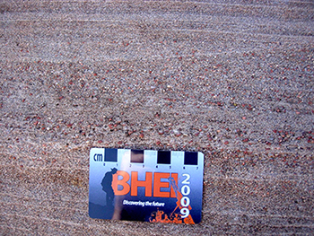
Figure 6 Close-up of Whyalla Sandstone outcrop near Whittata, 40 km southeast of Mount Gunson, showing the distinctive red lithic grains, a characteristic shared with the Elatina Formation. (Photo 417754)
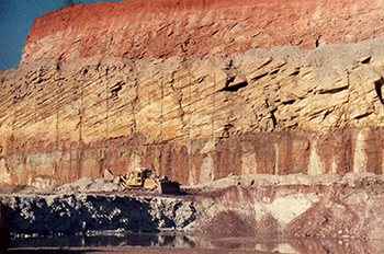
Figure 8 Cross-bedded Whyalla Sandstone overlying flat-bedded Whyalla Sandstone in the Cattle Grid Mine open cut. Whyalla Sandstone disconformably overlies mineralised Cattle Grid Breccia (visible lower left) and is overlain by orange-red Quaternary dune sands. (Photo 417753)
Coats and Preiss (1987) took the unusual step of defining a new type section for the Whyalla Sandstone (formerly Whyalla Sandstone Member), because of the widespread use of the term by exploration companies in drillhole logging, company reporting, mapping and scientific publications. Coats and Preiss proposed a new type section in the Cattle Grid Mine at Mount Gunson, where vertical sections through the formation are exposed by mining (Fig. 8). Should these exposures be flooded by groundwater after mining ceases, the interval in the Woomera Bore between 239 and 341 m was proposed as an alternative reference section. This redefinition brought the Whyalla Sandstone full circle, back to the district where the horizon was first recognised and to the location first chosen by Mason (1978) in assigning the unit to the ‘Cattle Grid formation’.
Exploration potential
The exploration and mapping processes that led to improved interpretation of the geology of the Mount Gunson area provided a stimulus for developing new models for exploration. The disconformable contact between the Whyalla Sandstone and Pandurra Formation is a proven copper target. Recent work by company THZ Pty Ltd targeted stratabound sulfide deposits in association with widespread areas of reduced Whyalla Sandstone where potential remains for further discoveries. A second article is in progress which examines the exploration potential of the Whyalla Sandstone.
Acknowledgements
I wish to pay tribute to Bren Thomson, a mentor who supported and encouraged my early efforts in stratigraphy on the Stuart Shelf. This account is in no way intended to reflect on Bren’s massive contribution to the geology of South Australia. I hope he would have approved this attempt to fill a gap in the record. My thanks to Wayne Cowley and Wolfgang Preiss, Geological Survey of South Australia, for reviewing the draft manuscript and providing many useful suggestions.
References
Dickinson SB 1953. The copper and manganese deposits of the Mount Gunson – Pernatty Lagoon district. In AB Edwards ed., Geology of Australian ore deposits. 5th Empire Mining and Metallurgical Congress, Melbourne; and The Australasian Institute of Mining and Metallurgy, Melbourne, pp. 517–523.
Johns RK 1965. Copper and manganese ore deposits of Pernatty Lagoon—Mt. Gunson district. In J McAndrew and RT Madigan eds, Geology of Australian ore deposits, volume 1, 2nd edn. 8th Commonwealth Mining and Metallurgical Congress and The Australasian Institute of Mining and Metallurgy, pp. 297–300.
King HF and Australian Mining and Smelting Company 1950. Mount Gunson copper, Pernatty Lagoon, SA, Broken Hill, NSW. Australian Mining and Smelting Company.
Singleton OP 1966. Petrological examination of two red sandstone specimens from the Pernatty Lagoon area, South Australia. Austminex.
Tonkin DG 1982. Mystery at Mt Gunson, Newsletter 166:31–35. CSR Limited.
Wainwright WE 1914. Report on copper deposits of Pernatty Copper Syndicate, Mining Review 20:41–51. Department of Mines, South Australia, Adelaide.


