Justin Gum
Geological Survey of South Australia, Department for Energy and Mining
Download this article as a PDF (2.7 MB); cite as MESA Journal 91, pages 51–65
Published December 2019
Contents
Introduction
Methodology
Gawler Craton gold mineral systems
Exploration implications
Conclusion
References
Introduction
Gold mineral systems of the central Gawler Craton region have been revised following a review for the Department for Energy and Mining’s Discover Gold program. Over 100 deposits and occurrences are described according to their host rocks, sulfide assemblages, element suites, vein styles, alteration, isotopic character and relationship to deformation (pre-, syn-, post-).
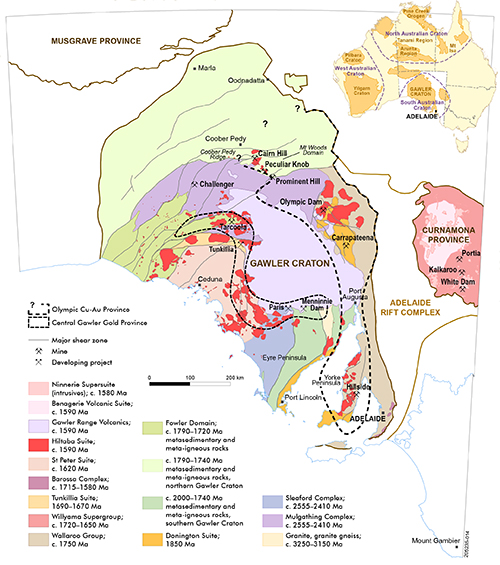
A significant motivation for this study was the persistent use of the ‘Central Gawler Gold Province’ (CGGP) as a term for any gold mineralisation occurring within an arcuate region around the southern and western edge of the Gawler Range Volcanic Province outcrop. Research on the deposits of the region since the CGGP was first described in the early 2000s (Fig. 1; Ferris and Schwarz 2003), has shown there to be a complicated collection of deposit characteristics across a much wider region than that originally proposed. This variation is mainly due to the grouping of various, genetically distinct mineral systems into the original single ‘province’. In addition, the lack of discovery of ‘gold-only’ systems outside of the CGGP is likely to be more a function of the depth of cover within the western Gawler and Olympic regions and the difficulty of targeting this type of system through that cover. Areas of the Olympic Domain where the cover is thinner have either not been sampled for gold during regional exploration or have been sampled with calcrete, which has proven to be a less than suitable method in many situations.
An important factor not considered in most of the previous studies was the overprinting or incorporation of earlier mineralisation within subsequent mineralising events. Major, crustal-scale, fluid conduits have been reactivated repeatedly during deformation of the craton and the passage of multiple mineralising events has the potential to explain much of the conflicting data seen in the Gawler Craton gold mineralisation. Local variation in the source rocks from which the metals in various occurrences were derived may also account for significant variations.
This article summarises the conclusions presented in the full project report (Gum in prep.).
Methodology
A selection of key gold deposits and occurrences for each area was evaluated in the first stage of the classification process. Deposits and occurrences were grouped by similar characteristics. Characteristics were selected to distinguish between mineralisation styles. The main characteristics focused on were alteration, vein style, host lithologies, element associations and sulfur isotopes, as these were the most commonly recorded information in exploration prospects. These were supplemented with fluid chemistry and temperature data where available. Generally one or two main deposits in each area has seen the widest variety of exploration methods and research, and these ‘type deposits’ were heavily used as the basis of classification.
The selected deposits were compared to known styles of gold mineralisation. Robert et al. (2007) defined a system which broadly covers all styles of gold mineral systems. Numerous subclassifications can be made under this system. Where possible, the broad classifications of Robert et al. (2007) were used, however, some deposits and occurrences were better described using a more specific subclassification (i.e. Groves et al. 2003).
Where no evidence of a basement source for gold mineralisation was found in an occurrence, it was labelled as a supergene occurrence and not included in the data analysed for this study.
Figures of the interpreted areal extent of the mineral systems and any contained mineral fields were produced, along with known gold occurrences or deposits and their interpreted genetic classification (Figs 3, 5, 6, 7). Only the reviewed and classified deposits are shown by their interpreted genetic style; deposits not reviewed are shown as white circles. The bounding regions of the mineral systems were not limited to known occurrences but were extrapolated to encompass areas of similar host lithology or igneous influence within which further mineralisation of that type may reasonably be expected to occur. Where time allowed, key structures associated with the mineral systems are included.
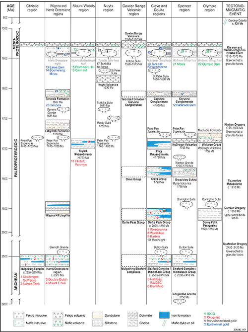
A time–space plot of the lithologies and mineralisation within the study region was produced to provide a context and enable comparison of mineralisation timing and styles (Fig. 2). The key features of the deposits and occurrences examined are tabulated for the various mineral fields in Tables 2–5. Overall, four gold mineral systems are recognised in the central Gawler Craton, and these are described below from oldest to youngest.
Gawler Craton gold mineral systems
Three major mineral systems corresponding to the Archean Sleaford, Paleoproterozoic Kimban and Mesoproterozoic Kararan deformation–magmatic events were recognised; the Kararan system was further subdivided into intrusive- and extrusive-related subsystems (Table 1). Clusters of mineral occurrences showed local similarities, which allowed grouping into mineral fields.
Table 1 Gawler Craton gold mineral systems and fields
| Mineral system | Mineral field | Style | Age (Ma) |
| Sleafordian | Christie | Orogenic (sediment) | c. 2520–2410 |
| Hilga | Orogenic (greenstone, BIF) | c. 2520–2410 | |
| Harris Greenstone | Orogenic (greenstone, BIF), oxidised intrusion related (low-sulfidation epithermal, alkalic) | c. 2520 | |
| Hall Bay | Orogenic (greenstone, BIF) | c. 2530–2410 | |
| Kyancutta | Orogenic (greenstone, BIF) | c. 2530–2410 | |
| Kimban | Mount Woods | Orogenic (sediment, BIF) | >1750 |
| Waddikee | Orogenic (greenstone) | c. 2000–1865 | |
| Cleve | Orogenic (sediment, BIF) | c. 1790 | |
| Middleback | Orogenic? | c. 2000–1865? | |
| Kararan (Gawler Range Volcanics) | Tarcoola | Oxidised intrusion related (low-sulfidation epithermal) | c. 1575 |
| Labyrinth | Oxidised intrusion related (low-sulfidation epithermal) | c. 1595–1575 | |
| Southern Gawler Range Volcanics | Oxidised intrusion related (low-sulfidation epithermal) | c. 1596–1587 | |
| Glenloth | Oxidised intrusion related (low-sulfidation epithermal, alkalic) | c. 1595–1575 | |
| Kararan (Hiltaba Suite) | Western Gawler | Oxidised intrusion related (mesozonal?, IOCG?) | c. 1610–1590 |
| Wudinna | Reduced intrusion related (mesozonal?) | c. 1610–1590 | |
| Tunkillia | Oxidised intrusion related (mesozonal?) | c. 1610–1590 | |
| Olympic | Oxidised intrusion related (IOCG, IOCG skarn) | c. 1610–1590 |
Sleafordian
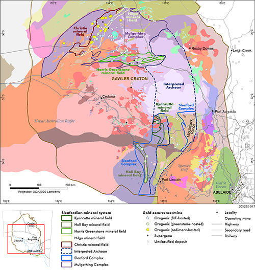
Figure 3 Sleafordian gold mineral system and associated mineral fields superimposed on interpreted solid geology (available via the South Australian Resources Information Gateway, SARIG).
The Sleafordian gold mineral system is interpreted to have been developed within the region of preserved Archean to early Paleoproterozoic age lithologies (c. 2555–2410 Ma; Reid et al. 2014), which wraps around the northern and southeastern side of the Gawler Craton (Fig. 3; Table 2). Belts of mineralised sedimentary, greenstone and banded iron formation (BIF) lithologies within this arcuate region can be subdivided into five mineral fields: Christie, Hilga, Harris Greenstone, Kyancutta and Hall Bay. These broadly follow stratigraphic belts of mafic to ultramafic volcanic and intrusive rocks and associated BIF, and carbonate and clastic sedimentary rocks. These belts may have been part of an originally contiguous zone which has been subsequently folded and dissected. Although no solid evidence exists for this connection, as no direct studies have been undertaken, geophysical, geochronological and stratigraphic similarities between the northern and southeastern extents of these belts suggests that similar rock packages extend under the Gawler Range Volcanics. This system is typified by deposits such as Challenger Mine and Golf Bore, Aurora Tank and Double Dutch prospects.
The region underwent deformation and granulite facies metamorphism during the 2480–2420 Ma Sleafordian Orogeny (Hand, Reid and Jagodzinski 2007) and the majority of mineralisation is likely to be of this age, although the only dated deposit is the Challenger Mine (c. 2520 Ma, according to McFarlane, Mavrogenes and Tomkins 2007). There is strong potential for further, new mineral fields to be discovered in the poorly explored region west and south of the Challenger mineral field.
This mineral system is interpreted to be a typical Archean orogenic system. All typical subtypes of orogenic gold mineral systems (sediment, greenstone and BIF hosted) are represented in the majority of the mineral fields. The Christie mineral field is currently unique in that mineralisation appears to be almost exclusively associated with clastic metasedimentary rocks. This poses an extra challenge to explorers, as there is almost no apparent geophysical signature to assist with targeting. The region hosting the gold mineralisation is generally of uniform, low-magnetic response.
The energy source for this system is interpreted to be the orogenic event itself (Sleafordian Orogeny) which may or may not be associated with synorogenic felsic magmas intruding at depth or within the volcano-sedimentary sequences. The mineralising fluid sources for orogenic deposits are metamorphosed basinal fluids, water released by metamorphic dehydration reactions or a mixture of both (Goldfarb and Groves 2015). Regardless of the specific origin, the process generally evolves a low-salinity fluid which is mobilised through the surrounding volcano-sedimentary sequence during orogenesis and this can accumulate metals and sulfur from the regions it passes through. In higher temperature systems, magmatic fluids may play a significant role, and in very shallow systems, meteoric waters may also contribute metals to the final mineralising fluids (Goldfarb and Groves 2015).
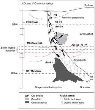
Figure 4 Orogenic gold mineral system showing elemental and metamorphic variation with depth. Reprinted from Goldfarb and Groves (2015, fig. 2; modified after Goldfarb et al. 1998, fig. 2) with permission from Elsevier.
From the elemental associations in the deposits of this mineral system (primarily Au, As, Ag; Table 2), the majority appear to be emplaced at or below the brittle–ductile transition (Fig. 4). This combined with the extensive vertical continuity of deposits such as Challenger – which is due to the ore zone being a fluid conduit for escape of large volumes of pressurised fluid across significant crustal volumes (Hronsky 2013) – confirm an orogenic style of mineralisation and indicate known gold occurrences in this mineral system are likely to have significant depth extensions. Various triggers have been documented for the deposition of gold in these systems. Most commonly pressure–temperature variations or lithological composition variation are responsible for gold precipitation. Because of the subsequent high-grade deformation and mobilisation of the Challenger deposit, it is difficult to determine where and what might have triggered deposition of mineralisation at this position. Deposition of mineralisation in other types of orogenic deposits (greenstone and BIF hosted) in this mineral system should be more obvious as they are likely to have a significant geochemical trigger rather than just a structural trap. Many questions still remain regarding the Archean mineralisation of the Christie mineral field due to its granulite facies deformation and the lack of research directed towards this deposit. For example, little is known about the exact nature of the mineralising fluids or the sulfur isotopes within the deposit. There are areas of the Sleaford and Mulgathing complexes which have been subjected to much lower deformation and discovery of mineralisation in these areas may shed further light on the genesis of the Sleafordian mineral systems.
The region around the Middleback Range (Fig. 3) has been highlighted, although no confirmed Archean gold mineralisation has been located here. This region is particularly complex with structural interlayering of Archean (Sleaford Complex) and Paleoproterozoic (Hutchison Group) lithologies. This region has then been very strongly overprinted by the intrusion of the Mesoproterozoic Hiltaba Suite, which would have masked the potential presence of Archean orogenic mineralisation.
Table 2 Sleafordian gold mineral system criteria
| Criteria | Christie mineral field | Hilga mineral field | Harris Greenstone mineral field | Hall Bay mineral field | Kyancutta mineral field |
| Type deposits | Challenger, Golf Bore | Hilga South, Birthday | Double Dutch, Boomerang | Bramfield, Mount Hope | WUD2C |
| Host | Christie Gneiss (sediment, felsic intrusive) | Christie Gneiss (mafic, ultramafic, BIF, sediment) | Lake Harris Komatiite, Hopeful Hill Basalt | Hall Bay Volcanics (BIF, gneiss) | Sleaford Complex (mafic and felsic granulite) |
| Vein style | Quartz–pyrite | Quartz–feldspar–pyrite | Quartz–calcite–pyrite | Quartz–pyrite | — |
| Alteration | Biotite? | Biotite, chlorite | Carbonate, biotite, talc, chlorite | Biotite | Sericite, chlorite |
| Sulfides | Pyrite, pyrrhotite, arsenopyrite | Pyrite, arsenopyrite | Pyrite, galena, (chalcopyrite) | Pyrite, arsenopyrite, pyrrhotite | Pyrite |
| Elements (dominant minerals in bold) | Au, As, Bi, (Ag, Co, Ni, Cu, Te) | Au, As, Ag | Au, As, Ag, Sb, Mo, Pb, Zn, Cu | Au, Ag, As, Cd, Pb, Zn | — |
| S isotopes δ34S (0/00) | — | — | — | — | — |
| Style | Orogenic (sediment) | Orogenic (greenstone, BIF) | Orogenic (greenstone, BIF), oxidised intrusion related (low-sulfidation epithermal, alkalic) | Orogenic (greenstone, BIF) | Orogenic (greenstone, BIF) |
| Mineralisation age | c. 2560–2500 Ma | c. 2560–2500 Ma | c. 2520 Ma | c. 2520 Ma | c. 2560–2500 Ma |
| Temperature | — | — | — | — | — |
| Depth of formation | Hypozonal (10–20 km) | Hypozonal (10–20 km) | Mesozonal (5–10 km) | Hypozonal (10–20 km) | — |
| Post-deposition modification | Regional granulite facies metamorphism to partial melting | Greenschist facies metamorphism | Greenschist facies metamorphism, deformation along regional shear zones | Regional granulite facies metamorphism | Regional granulite facies metamorphism |
Kimban
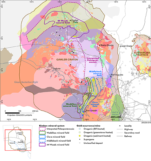
Figure 5 Kimban gold mineral system and associated mineral fields superimposed on interpreted solid geology (available via SARIG).
The Kimban gold mineral system is developed within the area of Paleoproterozoic basins that were deposited on the northern and southeastern sides of the Gawler Craton (Fig. 5; Table 3). These basins consist of quartzite, dolomite, iron formation, schist and amphibolite, which was deposited in a passive margin setting, possibly over several time periods. It is unclear whether this was one single basin margin or a series of basins, as they have been folded and thrust between inliers of Archean basement, particularly on the Eyre Peninsula. This system is typified by the Weednanna, Waddikee, Flintoft and Penrhyn prospects. There appears to be at least three separate periods of deposition; however, the similarity of the sequences and the incomplete geochronological dataset makes correlation difficult. Four mineral fields have been defined within this system: Mount Woods, Waddikee, Cleve and Middleback (Fig. 5). These, to some extent, may represent separate basins within the region.
They were subsequently deformed by the Kimban Orogeny (c. 1735–1690 Ma) with the associated felsic intrusions of the Peter Pan Suite (1745–1700 Ma). Because of the level of deformation, it is often visually and geochemically hard to distinguish the Archean from the Paleoproterozoic rocks unless geochronology is undertaken. This has led to confusion in distinguishing between the Sleafordian and Kimban systems in the area. It is unlikely, but not impossible, that Kimban orogenic fluids have mineralised Sleaford Complex lithologies where they have provided a suitable geochemical or structural depositional site as the Archean Sleaford Complex has occasionally been thrust over the Paleoproterozoic Hutchison Group.
The extremely wide time extent for this mineral system (c. 2000–1700 Ma) reflects the lack of geochronology available for the mineralisation potentially belonging to this system. The Darke Peak Group (c. 2000–1865 Ma) and possibly the Wilgena Hill Jaspilite are potentially the oldest sediments deposited, although no reliable age has been determined for the Wilgena Hill Jaspilite. These could potentially have been mineralised during the Cornian Orogeny or Donington Suite intrusion, but this deformation event appears localised to the very eastern margin of the Gawler Craton and southern Yorke Peninsula. The remaining Paleoproterozoic sediments were deposited between 1790 and 1750 Ma and were probably mineralised during the Kimban Orogeny and the intrusion of the Peter Pan Suite. It is also unlikely, but not impossible, that this event influenced the mineralisation of the Darke Peak Group. It is unlikely that the subsequent Kararan event would have emplaced orogenic-style mineralisation, as higher grade deformation is localised into selected shear zones by strain partioning.
To complicate matters further, the majority of the Paleoproterozoic basins have been overprinted to a greater or lesser extent by the Hiltaba magmatic event. This has made it particularly difficult in places to distinguish between remobilised, primary sedimentary iron formation and overprinting skarn mineralisation. As orogenic mineralisation related to this system is only likely be associated with primary BIFs, this is an important distinction to make.
This mineral system is also interpreted to be primarily an orogenic BIF or sediment hosted gold system. The Hutchison Group mainly consists of clastic and chemical sediments deposited in a shallow marine, shelf environment (Szpunar et al. 2011). There are some intercalated volcanic units of limited extent. Orogenic mineralisation is mainly confined to the sediment and BIF hosted subgroups, but rare greenstone occurrences are present (Waddikee). The characteristics of the various mineral fields are outlined in Table 3.
The mineralising fluids are assumed to be mainly derived from basinal formation fluids. There has been very little study on the deposits in this group with Weednanna being the only exception. There are two stages of felsic intrusives at Weednanna. Undeformed granites have been dated at 1584 ± 5 Ma (Reid and Jagodzinski 2012). An older suite of deformed felsic intrusives have yet to be dated but are assumed to be Kimban Peter Pan Suite. Gold mineralisation may be associated with the intrusions, however, a spatial and genetic relationship with Peter Pan Suite granites has not been demonstrated. This suggests it is possible that there is also an intrusion-related mineral system associated with the Kimban intrusives present in the southern Gawler Range Volcanics region.
Alteration along the fluid pathways is often recognisable as magnetite destruction in the BIF units. As the Hutchison Group BIF units have primarily been the focus of iron exploration, areas of lower magnetic response have been avoided in previous exploration. A good example of this is the Flintoft prospect in the Mount Woods mineral field (Davies, Morris and Crettenden 1997). A single line of reverse circulation drillholes across a zone of lower magnetic response intersected gold mineralisation (4 m at 4.58 g/t from 84–88 m) with several other anomalous gold zones as well. A limited follow-up program of calcrete sampling outlined significant gold anomalism. A short program of shallow (<40 m, average depth 17.1 m) vertical aircore drilling (49 holes) was subsequently carried out; however, this type of program is unlikely to adequately test this style of mineralisation.
Although no gold-only mineralisation has been identified in the Middleback Range region, there is high potential for BIF hosted occurrences to be present. This region has historically been the focus of iron ore exploration and a small amount of iron oxide – copper–gold (IOCG) exploration. It has not seen a significant amount of gold exploration.
Table 3 Kimban gold mineral system criteria
| Criteria | Mount Woods mineral field | Waddikee mineral field | Cleve mineral field | Middleback mineral field |
| Type deposits | Flintoft, Penrhyn | Waddikee, Moonlight | Weednanna, Bartel | No discoveries yet |
| Host | Skylark Metasediments | Darke Peak Group (graphitic schist, amphibolite, marbles) | Cleve Group (schist, quartzite, carbonates) | Middleback Group, Broadview Schist |
| Vein style | Quartz–carbonate | Quartz | Quartz–pyrite | Quartz–pyrite? |
| Alteration | Chlorite, carbonate | Biotite | Silica, manganese, carbonate, (sericite, chlorite) | — |
| Sulfides | Pyrite, chalcopyrite | Pyrite, pyrrhotite, galena, chalcopyrite | Pyrite, argentite, chalcopyrite, galena, arsenopyrite | — |
| Elements (dominant minerals in bold) | Au, Fe, Zn, Pb, Cu, Ag, As | Au, Bi, Pb, Zn, Ag, As, Cu | Au, Pb, Cu, Ag, Zn, Mo, As, Bi | Au, Zn, As, Cu? |
| S isotopes δ34S (0/00) | — | — | 3–7.5 | — |
| Style | Orogenic (sediment, BIF) | Orogenic (greenstone) | Orogenic (sediment, BIF) | Orogenic? |
| Mineralisation age | c. <1730 Ma? | c. <1900 Ma? | c. <1730 Ma? | c. <1730 Ma? |
| Temperature | — | — | — | — |
| Depth of formation | Hypozonal (10–20 km) | Hypozonal (10–20 km) | Hypozonal (10–20 km) | — |
| Post-deposition modification | Greenschist to granulite metamorphism | Greenschist to granulite metamorphism | Greenschist | Greenschist |
Kararan (Gawler Range Volcanics)
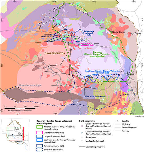
Figure 6 Kararan (Gawler Range Volcanics) gold mineral system and associated mineral fields superimposed on interpreted solid geology (available via SARIG).
The Kararan (Gawler Range Volcanics) gold extrusive mineral system is defined by the original extent of the subvolcanic system of the Gawler Range Volcanics event (Fig. 6; Table 4). This system is typified by the Tarcoola and Glenloth mines as well as the Minos and Parkinson Dam prospects. Four mineral fields are defined within this system (Tarcoola, Labyrinth, Glenloth and Southern Gawler Range Volcanics) based mainly on local criteria affecting the mineralising fluids and deposition of the mineralisation in the area. Other mineral fields are likely to be defined with further work.
The mineral system is postulated to extend across the original extent of the Gawler Range Volcanics outcrop and associated subvolcanic hydrothermal systems. While this original extent is hard to define due to subsequent erosion, the distribution of Gawler Range Volcanics felsic dykes gives some indication and has been used to define the extent of the system in this study.
This mineral system is interpreted to be a typical low-sulfidation, subalkalic epithermal system associated with oxidised intrusions. The key distinction between the deposits included in this system and intrusion-related epizonal to mesozonal mineralisation is the metals associated with the deposits. They are generally much richer in Ag, strongly anomalous in Pb and Zn, and while As is present and can be used as a pathfinder it is not a dominant component. The current level of exhumation of the various occurrences of mineralisation varies dramatically. Deposits such as Parkinson Dam and Telephone Dam are quite shallow and are polymetallic. In contrast, deposits such as Tarcoola are more strongly gold mineralised and are interpreted to have been exhumed to a greater degree and reflect a deeper level of the mineral system as there is only minor evidence of classic banded and vuggy, shallow epithermal textures (Hein, Both and Bone 1994). The primary distinguishing characteristics of the various mineral fields within this system are outlined in Table 4.
Table 4 Kararan (Gawler Range Volcanics) gold mineral system criteria
| Criteria | Tarcoola mineral field | Labyrinth mineral field | Southern Gawler Range Volcanics mineral field | Glenloth mineral field |
| Type deposits | Perseverance, Tarcoola Blocks, Daly’s Dream | Minos, North Hicks, Arcoordaby | Weednanna, Parkinson Dam, Uno | Fabian, Royal Tiger, Glen Markie, Kingfisher |
| Host | Paxton Granite, Tarcoola Formation, Gawler Range Volcanics, Kenella Gneiss | Kenella Gneiss, Glenloth Granite, Lake Harris Komatiite, Hopeful Hill Basalt | Hutchison Group (carbonates, BIF, gneiss), Corunna Conglomerate, Broadview Schist | Glenloth Granite (Archean) |
| Vein style | Colloform quartz, quartz–(calcite–pyrite) | Quartz–pyrite–(carbonate) | Quartz–sulfide, pyrite–chlorite | Quartz–(ironstone/pyrite?) |
| Alteration | Sericite, chlorite | Sericite, chlorite, epidote, carbonate, silica | Sericite, chlorite, biotite, silica | — |
| Sulfides | Pyrite, galena, sphalerite, chalcopyrite, (arsenopyrite) | Pyrite? | Pyrite, pyrrhotite, arsenopyrite, galena | Pyrite? |
| Elements (dominant minerals in bold) | Au, Ag, Pb, Zn, Cu, As, Te | Au, Pb, Zn, As, ? | Au, Pb, Zn, Cu, As, Bi, Sn | Au |
| S Isotopes δ34S (0/00) | +7.45 | — | +7.5 | |
| Style | Oxidised intrusion related (low-sulfidation epithermal) | Oxidised intrusion related (low-sulfidation epithermal) | Oxidised intrusion related (low-sulfidation epithermal) | Oxidised intrusion related (low-sulfidation epithermal, alkalic?) |
| Mineralisation age | 1582 ± 5 Ma | c. 1580 Ma | 1580 ± 10 Ma (reset?) | 1580 ± 10 Ma (reset?) |
| Temperature | ~150–340 °C | — | ~300–400 °C | |
| Level of emplacement | <1 km | <1 km | <1 km | <1 km |
| Post-deposition modification | Negligible | Brittle faulting | Negligible | Negligible |
Fluid flow modelling by the predictive mineral discovery Cooperative Research Centre (Potma and Bastrakov 2006) has shown that a thick blanket of Gawler Range Volcanics would act as an aquitard, promoting hydrothermal alteration of the underlying lithologies and focusing fluid flow through any fault or fracture zones penetrating the volcanics. This is supported in the Tarcoola district with evidence from sulfur isotopes (Hein, Both and Bone 1994) showing sulfur and probably metals being derived from the underlying Tarcoola Formation sediments. There are no obvious indications of widespread alteration of the Tarcoola Formation, which also supports the deeper level of this system. In the southern Gawler Range Volcanics, basement lithologies sitting below the base of the volcanics have generally undergone extensive argillic alteration associated with the mixing of hydrothermal fluids and shallow groundwater (Wade et al. 2014; Curtis, Wade and Reid 2018).
This type of system is likely to be strongly affected by the local lithologies underlying the individual hydrothermal cells. The fluid flow is also likely to migrate along long-lived fracture systems, which could potentially have been mineralised by previous orogenic events. Thus, confusion arises with hybrid systems showing characteristics of multiple styles of mineralisation (i.e. Boomerang, Weednanna).
The energy source for this system is the subvolcanic hydrothermal systems of the Gawler Range Volcanics. The original distribution of the Gawler Range Volcanics was much greater than the current exposed outcrop. Exploration over the past 10–15 years has expanded the known occurrence of the Gawler Range Volcanics greatly. However, the original maximum distribution of the extrusive lavas, and more particularly the original distribution of the eruptive centres, is still open to debate.
Many of the mineral fields defined in this system show a very strong association with a conjugate set of NW- and NE-trending structures (Fig. 6). The age of original formation of these structures has not been determined, but they are definitely post-Sleafordian. As the sedimentation of many of the basins hosting this mineral system appears to be controlled by movements along these structures, they are most likely of late Kimban age. The current extent of preservation of the pre-Gawler Range Volcanics sedimentary basins hosting the mineralisation (Tarcoola Formation and Corunna Conglomerate) has been controlled by movement along these structures (Fig. 6). It is possible that these structures also controlled the original depocentres for these sedimentary basins and are the primary mineralising conduits as many of the deposits and mineral occurrences interpreted to be related to this mineral system are vein-hosted systems within either NW- or NE-trending structures (Fig. 6).
It has been shown that the main mineralising structure at Tarcoola is the NNE-oriented Perseverance Shear Zone, which was mineralised late in the Kararan Orogeny during N–S-directed compression (Budd and Skirrow 2007; Pawley and Wilson 2019). The NW-oriented structures are also mineralised in the Labyrinth mineral field, however, these structures are unlikely to have been dilational under N–S compression and may reflect an earlier stage of mineralisation under a different deformational regime. This would support a Kimban age for the formation of the structures, which have been remobilised multiple times subsequently.
A common feature of many of the deposits within this mineral system is the presence of epithermal textures within the veins. The nature and frequency of the veins varies strongly between deposits indicating that the deposits in this mineral system display a wide range of paleodepths. Unfortunately, in many of the deposits, there is no information on whether the epithermal veins are genetically associated with the mineralisation or are just overprinting at a later stage. This is another area which requires further research.
Kararan (Hiltaba Suite)
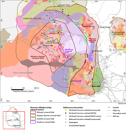
The Kararan (Hiltaba Suite) gold mineral system is defined as all the mineral systems related to Hiltaba intrusive magmas. The previously defined Olympic mineral field (domain) has been included although this has been described as a separate mineral system in its own right (Skirrow et al. 2018). This system is typified by the Olympic Dam Mine, and Barns and Tunkillia deposits. The Western Gawler, Tunkillia and Wudinna mineral fields have also been added as subdivisions of this mineral system (Fig. 7; Table 5).
Table 5 Kararan (Gawler Range Volcanics) gold mineral system criteria
| Criteria | Western Gawler mineral field | Wudinna mineral field | Tunkillia mineral field | Olympic mineral field |
| Type deposits | Yumbarra, Pureba, Yerda West | Barns, Baggy Green, Toondulya | Tunkillia Area 191, Tomahawk, Myall, Sheoak | Olympic Dam, Carrapateena, Prominent Hill |
| Host | Hiltaba Suite, Nuyts Volcanics, St Peter Suite, Kenella Gneiss | Tunkillia Suite (felsics), Hiltaba Suite (mafics, ultramafics), Broadview Schist | Tunkillia Suite felsics and minor mafics (Hiltaba Suite?) | Hiltaba Suite, Wallaroo Group, Gawler Range Volcanics, Broadview Schist |
| Vein style | Quartz–(pyrite), ? | Quartz–pyrite | Quartz–pyrite–(galena–sphalerite) | Calcite–barite–fluorite–hematite–chalcopyrite veins |
| Alteration | Hematite, sericite, chlorite, silica | Sericite, chlorite, biotite | Sericite, chlorite, hematite, silica, (epidote) | Hematite, chlorite, sericite, carbonate |
| Sulfides | Pyrite, ? | Pyrite, chalcopyrite, galena | Pyrite, galena, sphalerite | Chalcopyrite, pyrite, bornite |
| Elements (dominant minerals in bold) | Au, Ag, Zn, Pb, ? | Au, Ag, Cu, Pb, Bi, Mo | Au, Ag, Pb, Zn, Sb, La | Cu, Fe, Au, U, Ag, La, Ce, Te |
| S isotopes δ34S (0/00) | — | +1.15 | +0.09 | –8 to +12 |
| Style | Oxidised intrusion related (mesozonal?, IOCG?) | Reduced intrusion related (mesozonal?) | Oxidised intrusion related (mesozonal?) | Oxidised intrusion related (IOCG) |
| Mineralisation age | c. 1590? | c. 1590? | 1580 ± 10 Ma (reset?) | c. 1590 |
| Temperature | — | — | ~300–400 °C | Mixing >400 °C/<100 °C |
| Level of emplacement | — | >1 km | >1 km | 0.5–2 km |
| Post-deposition modification | Fault brecciation, none? | Greenschist to granulite metamorphism | Mylonitic shearing | Fault brecciation, groundwater infiltration |
The Western Gawler mineral field is very broadly defined and covers the known outcrop or subcrop of the Hiltaba magmatic event intrusives to the west of the Olympic mineral field. Only a handful of occurrences have been attributed to this system and most are very poorly defined. Many of the attributes linking these occurrences to Hiltaba intrusives may be wishful thinking on the part of the over enthusiastic geologist logging the chips onsite during drilling. Much more analysis is required to confirm the extent and nature of this system.
The Wudinna and Tunkillia mineral fields have tentatively been included as the mineralisation has much more in common with intrusion-related gold systems than epithermal gold systems, but these deposits may represent a continuum with the epithermal systems.
The mineralisation grouped into this system generally has the character of a reduced intrusion-related system. This style of mineralisation is associated with equigranular, multiphase, moderately reduced granodiorite–granite stocks and batholiths (Robert et al. 2007). The gold mineralisation is commonly associated with sericite–carbonate alteration and pathfinder elements include Bi, W, As, Mo, Te and in some cases Sb.
The energy source is that of the intrusive bodies themselves and the mineralisation is closely associated with the intrusive bodies and either occurs within the intrusion or within 1–2 km at most of the intrusive margins. The majority of the mineralisation seen in this system of the Gawler Craton occurs outside of intrusions, and in most the source intrusion is difficult to determine. However, no specific research has been conducted into which intrusive bodies may be the source of the fluids forming the occurrences in this mineral system. Sulfur isotope analysis at both Tunkillia and Barns suggests a magmatic source for the fluids, supporting the intrusion-related model.
This type of mineral system does not require large-scale structural conduits for fluid migration from the source to the deposition site. However, there are numerous examples (Tintina Belt, Alaska) of this type of mineralisation where the host intrusive bodies have been localised along structural corridors (Hart 2005). The intrusion of Hiltaba magma, although widespread across the Gawler Craton, is commonly focused on major regional structures. These frequently reactivated structures would have made excellent conduits for this style of mineralising fluid and may explain why there is no close association between intrusions and mineralisation.
This type of mineralisation can have quite wide halos of typically carbonate–sericite alteration, which can be used as a vector to mineralisation. The mineralisation within the Tunkillia mineral field is typically associated with wide zones of alteration
An interesting feature of the mineralisation within the Tunkillia mineral field is the mylonitic deformation it has undergone. Generally the Kararan deformation is much lower grade, however, the Mineral Systems Drilling Program (Fabris et al. 2017) intersected mylonitic deformation of Gawler Range Volcanics associated with a N–S-trending structure in the southern Gawler Range Volcanics region. This was attributed to strain partitioning and could explain the high strain in the Tunkillia mineral field. The alternative interpretation is that the mineralisation is actually older and may represent an intrusion-related system associated with the Tunkillia Suite. Again, further research is required to determine exact origin of the mineralisation within this mineral field.
Exploration implications
The re-evaluation of the mineralisation within this new classification system has highlighted many newly prospective areas, as well as shed light on some controls on mineralisation which were not readily apparent previously.
Lithology
Certain lithologies appear more favourable for mineralisation than others.
The Sleafordian mineral fields defined in this study are broadly packages of greenstone and BIF lithologies in known Archean stratigraphy. As the majority of these areas are under cover, magnetic signatures are primarily used to determine underlying stratigraphy. In addition, Paleoproterozoic BIF packages sit on top of, and have been complexly folded within Archean gneissic lithologies, particularly in the Kyancutta mineral field (Lane et al. 2015), making exploration targeting difficult.
Mineralisation within the Christie and Kyancutta mineral fields is associated with lithologies which are difficult to distinguish with geophysical methods. Generally these areas are described as ‘magnetically quiet’ (McFarlane, Mavrogenes and Tomkins 2007). There are numerous such magnetically quiet regions associated with the greenstone and BIF units in the Harris Greenstone, Kyancutta and Hall Bay mineral fields which have seen little or no exploration but which possibly host Challenger-style orogenic mineralisation. Mineralisation within these fields will best be detected with geochemical methods which directly sample saprock.
Many questions still remain around exactly what the Hutchison Group consists of and the original extent of the basin(s). Geochronology has suggested a wide age distribution of very similar packages of stratigraphy which had previously been interpreted as correlatives (Szpunar et al. 2011). Detailed stratigraphic section logging in conjunction with geochemistry, petrology and detrital zircon analysis may answer some of these questions and help define the number and the extent of these mineral systems and fields.
Previous work has shown the importance of certain basement lithologies in sourcing and hosting mineralisation in the Kararan (Gawler Range Volcanics) mineral system (i.e. Tarcoola Formation and Corunna Conglomerate). Further research and exploration is likely to determine the relative importance of other basement lithologies as well. Some lithologies (Glenloth Granite and Labyrinth Formation) have a vague spatial relationship with mineralisation, which has yet to be clearly defined.
Geochemical exploration
A large proportion of the various mineral systems defined by this study have been covered with regional calcrete geochemical sampling, particularly after the discovery of the Challenger deposit was falsely attributed to this sampling method (Edgecombe 1997). Extensive research by the Cooperative Research Centre for Landscape Environments and Mineral Exploration has shown this method to be very useful if conducted in a very rigorous manner, with a very good understanding of the regolith in the target area and descriptions of the sampled material. Unfortunately, many of the surveys undertaken have not proven effective in testing the geochemistry of the underlying basement. Consequently many areas still require testing with a more effective geochemical survey method. Biogeochemistry and ultrafine-fraction sampling are methods which have had some recent success as alternate surface sampling mediums. Again, these require a high level of understanding of the materials being sampled along with the regolith in the target region. Extensive orientation sampling is strongly recommended.
Structure
Detailed structural analysis is required to locate suitable conduits for mineralisation. These conduits are likely to be closely associated with major regional structures but not within them. Subsequent deformation may have also remobilised mineralisation away from its primary deposition site, but this is not likely to be very far (<100–200 m?).
Very little work has been done on interpretation of structures which may have controlled the transport of mineralised fluids during the various mineralising events. Many primary structures are obvious and have been reactivated subsequently across multiple deformational events before cratonisation. McFarlane, Mavrogenes and Tomkins (2007) interpreted the nature of premetamorphic alteration at the Challenger deposit using lithogeochemistry and these principles could potentially be used to locate signs of fluid migration along secondary and tertiary structures.
The newly acquired Gawler Craton Airborne Survey (GCAS) data has enabled an order of magnitude increase in the level of information obtainable in this area (Katona 2019). An ongoing project within the Geological Survey of South Australia (GSSA) is providing this precompetitive data to industry (Pawley and Wilson 2019). This work has already highlighted the importance of a good structural framework in determining the controls on mineralisation and is likely to further enhance targeting constraints for exploration.
Conclusion
The gold mineral systems of the Gawler Craton are far more complex than previously assumed. At least three different mineral systems can be defined across the region with the possibility of at least two more being present. Gold mineralisation events appear to be associated with at least some phases of all the major deformational events affecting the region.
Comparative research into the nature and origin of the gold mineralisation across the Gawler Craton is lacking in many areas and would greatly assist the task of explorers in locating further significant (>1 Moz) deposits in this highly prospective region.
Further work is required to refine the mineral field definitions by collecting a more consistent, wider dataset. This could easily be done with spectral scanning of a wider selection of deposits to objectively define alteration styles and collection of more consistent geochemistry using pXRF methods. Further study of stable isotopes (particularly sulfur and lead) and fluid inclusions across a wider range of deposits will dramatically assist in classification of the mineral styles in this region. Many questions still remain as to the exact nature of many of these mineral systems’ deposits.
Finally, the methodology of this study could be used to extend the definition of the younger gold mineral systems across the rest of the state. The mineral system model is very useful for highlighting regions that have strong potential to host further mineralisation.
Acknowledgements
Thank you to Marc Twining (GSSA), Justin Payne (University of South Australia) and especially Mark Pawley (GSSA) for their very helpful reviews of this article. Also thank you to all GSSA staff for the robust discussions over the last year which have helped inform and direct this project.
References
Budd A and Skirrow RG 2007. The nature and origin of gold deposits of the Tarcoola Goldfield and implications for the Central Gawler Gold Province, South Australia. Economic Geology 102:1541–1563.
Goldfarb RJ and Groves DI 2015. Orogenic gold: common or evolving fluid and metal sources through time. Lithos 233:2–26.
Groves DI, Goldfarb RJ, Gebre-Mariam M, Hagemann SG and Robert F 1998. Orogenic gold deposits—a proposed classification in the context of their crustal distribution and relationship to other gold deposit types. Ore Geology Reviews 13:7–27.
Groves DI, Goldfarb RJ, Robert F and Hart CJ 2003. Gold deposits in metamorphic belts: overview of current understanding, outstanding problems, future research, and exploration significance. Economic Geology 98:1–29.
Gum J in prep. South Australian mineral systems: Gawler Craton, gold, Report Book 2019/00025. Department for Energy and Mining, Adelaide.
Hand M, Reid A and Jagodzinski L 2007. Tectonic framework and evolution of the Gawler Craton, southern Australia. Economic Geology 102:1377–1395.
Hart CJR 2005. Classifying, distinguishing and exploring for intrusion-related gold systems. The Gangue 87:1–9.
Hein KAA, Both RA and Bone Y 1994. The geology and genesis of the Tarcoola gold deposits, South Australia. Mineralium Deposita 29:224–236.
Hronsky J 2013. Controls on high-grade Au ore-shoots: towards a new paradigm. Extended Abstracts: East Asia Symposia Bali 27-29 May 2013, Bulletin 57. Australian Institute of Geoscientists, Sydney.
Lane K, Jagodzinski EA, Dutch R, Reid AJ and Hand M 2015. Age constraints on the timing of iron ore mineralisation in the southeastern Gawler Craton. Australian Journal of Earth Sciences 62(1):55–75.
McFarlane CRM, Mavrogenes JA and Tomkins AG 2007. Recognizing hydrothermal alteration through a granulite facies metamorphic overprint at the Challenger Au deposit, South Australia. Chemical Geology 243:64–89.
Potma W and Bastrakov E 2006. Tarcoola modelling: predictive targeting outcomes, Central Gawler Gold Province Modelling Project Update. Predictive Mineral Discovery CRC.
Reid AJ, Jagodzinski EA, Fraser GL and Pawley MJ 2014. SHRIMP U–Pb zircon age constraints on the tectonics of the Neoarchean to early Paleoproterozoic transition within the Mulgathing Complex, Gawler Craton, South Australia. Precambrian Research 250:27–49.
Robert F, Brommecker R, Bourne BT, Dobak PJ, McEwan CJ, Rowe RR and Zhou X 2007. Models and exploration methods for major gold deposit types. In Milkereit B ed., Proceedings of Exploration 07: Fifth Decennial International Conference on Mineral Exploration, pp. 691–711.
Szpunar M, Hand M, Barovich K, Jagodzinski E and Belousova E 2011. Isotopic and geochemical constraints on the Paleoproterozoic Hutchison Group, southern Australia: implications for Paleoproterozoic continental reconstructions. Precambrian Research 187(1-2):99–126.


