Adrian Fabris1, Laz Katona1, Georgina Gordon1, Gary Reed1, Tim Keeping1, George Gouthas1 and Greg Swain2
1 Geological Survey of South Australia, Government of South Australia
2 Monax Mining Limited
Download this article as a PDF (6.8 MB); cite as MESA Journal 87, pages 15–27
Introduction
Figure 1 Location of the Punt Hill study region shown over residual gravity image. Prominent features include high magnitude and amplitude gravity anomalies within the southwestern and western portion of the project region and a series of NW–SE-orientated linear gravity anomalies through the central Punt Hill region. Drillholes utilised in the project are shown.
South Australia hosts one of the world’s great iron oxide – copper–gold (IOCG) terranes. Termed the Olympic Cu–Au Province (Skirrow et al. 2007), this belt is renowned as the host to Olympic Dam, the type example of breccia-hosted, hematite-rich IOCG deposits (Groves et al. 2010). The same thermal event resulted in variants of this deposit class throughout the Olympic Cu–Au Province and includes skarn-dominated mineralisation where hydrothermal fluids interacted with carbonate-rich lithologies.
Punt Hill is the name given to a series of Cu–Au skarn prospects, located 105 km NNW of Port Augusta (Fig. 1; Swain et al. 2017), and has been shown to be part of the ~1.6 Ga thermal event that formed other well-known IOCG deposits in the region, in particular Carrapateena which is located a further 40 km north (Reid et al. 2011). The Punt Hill project includes some of the best examples of widespread skarn development in the eastern Gawler Craton. Although highly prospective, exploration in the region is both expensive and technically challenging owing to hundreds of metres of post-mineralisation cover.
As part of a broader study aiming to characterise proximal to distal footprints of IOCG-type deposits in the eastern Gawler Craton (Fabris et al. 2013; Fabris et al. 2015), the Geological Survey of South Australia, in collaboration with the then tenement holders Monax Mining, used the Punt Hill region to develop a multidisciplinary approach for characterising, mapping and predicting alteration associated with skarn-hosted Cu–Au mineralisation. A particular focus was given to progressing the understanding of skarn development and generating exploration criteria and predictive models to aid future exploration in the region. This article provides an overview of the main outcomes of the project and is a summary of results provided in Fabris et al. (2018).
Geology
Figure 2 Conceptual SW–NE geological cross-section through the Punt Hill region. Section location indicated on Figure 1. Tilting on Paleoproterozoic units is interpreted to have occurred during Mesoproterozoic extension associated with the deposition of the Pandurra Formation. Further extension during extrusion of the Beda Basalt is indicated by significant thickening to the northeast.
The Punt Hill region is located in the central Olympic Cu–Au Province (Fig. 1). The oldest unit known in the study area is granite of the c. 1850 Ma Donington Suite (Reid et al. 2011; Jagodzinski 2005; Schwarz 2003). Donington Suite locally forms basement to a sequence of laminated silty and variably calcareous metasedimentary rocks thought to be equivalents of the Wandearah Formation of the c. 1760 Ma Wallaroo Group (Cowley, Connor and Zang 2003). To the east of the Elizabeth Creek Fault, these low metamorphic grade metasediments (Reid and Fabris 2015) are preserved within a series of NW-trending half-grabens (Fig. 2) and host the majority of known mineralisation in the Punt Hill region. Variably altered Wallaroo Group within these half-grabens is thought to be the primary control on similarly aligned residual gravity anomalies evident in the region (Fig. 1).
Drillhole intersections indicate that east of the Elizabeth Creek Fault, Wallaroo Group metasediments are typically <250 m thick. Preserved thickness increases to the west of the Elizabeth Creek Fault (e.g. 663 m intersected in drillhole PN-07-09; Giles 2002). Wallaroo Group is thin to absent in the northern part of the Punt Hill project area (e.g. absent in drillholes FTDD01, HL002, NHD1) and along up-faulted basement blocks (e.g. drillholes NNDD1, BLDD01, SDDD01).
Over the Punt Hill series of prospects, the Wallaroo Group is variably overlain by felsic volcaniclastics and lavas of the Gawler Range Volcanics (Allen et al. 2008; Allen et al. 2003). Drilling to date has intersected thicknesses of <180 m of these volcanics.
Proterozoic crystalline units are unconformably overlain by arenaceous redbeds of the c. 1490 Ma Pandurra Formation (Beyer et al. 2018; Cowley 1991). Variation in accommodation space controlled by continental extension (Beyer et al. 2018) and post-depositional erosion led to significant differences in thickness of Pandurra Formation across the project area (Fig. 2), from being completely absent to some areas with intersections up to 306 m (drillhole NNDD1). The Pandurra Formation and underlying units are intruded by mafic dykes of the c. 800 Ma Gairdner Dolerite (Cowley and Flint 1993). The Gairdner Dolerite can be recognised in regional aeromagnetic datasets as long, subparallel, linear anomalies, with a characteristic northwest orientation.
Overlying the Pandurra Formation is the Beda Basalt, which consists of amygdaloidal, layered, subaerial basalts and are the extrusive equivalent of the Gairdner Dolerite. Unconformably overlying the Beda Basalt, are the flat-lying lithologies of the Adelaidean Stuart Shelf (Preiss 1987), comprising the Umberatana (Tapley Hill Formation and Whyalla Sandstone) and Wilpena (Nuccaleena Formation; and Tregolana Shale, Corraberra Sandstone and Simmens Quartzite members) groups. The thickness of Adelaidean units ranges from ~250 m in the northwest to >1,000 m in the southeast of the project area. A thin veneer of Quaternary and Recent sediments cover the project area.
The interpreted stratigraphic relationships and inferred fault architecture are illustrated in Figure 2.
Alteration and mineralisation
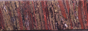
The Punt Hill region incorporates several Cu–Au (Ag–Zn–Pb) prospects associated with calcic-dominated, garnet–pyroxene skarn within metasedimentary units of the Wallaroo Group (Table 1; Fig. 3; Swain et al. 2017). To date, only minor copper mineralisation has been intersected within the underlying Donington Suite granite or overlying Gawler Range Volcanics. Both these units host variably intense K-feldspar, white mica, chlorite, hematite and carbonate alteration. Notably, elevated copper values in these units are associated with an increased degree of hematite alteration.
Petrographic studies of the skarn system describe a prograde garnet- and pyroxene-dominant mineral assemblage, overprinted by a diverse retrograde assemblage of amphibole, calcite, talc, chlorite, K-feldspar, hematite, sulfide (chalcocite, bornite, chalcopyrite, sphalerite, galena, pyrite), fluorite, apatite, barite, anhydrite, epidote, tourmaline, titanite, biotite and native gold (Fig. 3; Mason 2012). Although mineralisation is commonly associated with increased iron content (up to 20% Fe2O3), iron oxides form only a minor component of the alteration assemblage. Instead, a significant proportion of iron is as silicate in iron-rich garnet (andradite). Sulfide precipitation is associated with the later paragenetic or retrograde phase of the skarn system, which is similar to that described for other skarn systems worldwide (Meinert 1992). The specific processes and fluid source driving the prograde–retrograde evolution of the alteration system in the Punt Hill region have not been studied in detail. Typically, alteration and mineralisation result from either a single fluid source generated during cooling of an intruding pluton, and then progressing through a heating and cooling event, or, mixing of magmatic–hydrothermal fluids with distinct fluid sources in chemical disequilibrium (Einaudi, Meinert and Newberry 1981).
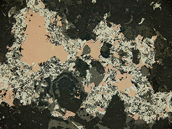
At Punt Hill, sulfides predominantly form in veins that crosscut early prograde alteration (commonly containing quartz, calcite, hematite, amphibole and chlorite) and as interstitial growth between garnet and pyroxene grains (Fig. 3e). The copper sulfide tenor is controlled by the degree to which retrograde fluids are oxidised, where bornite (and rare native gold) occurs within hematite-bearing zones and chalcopyrite occurs within more chlorite-bearing zones (relatively reduced; Mason 2012). Importantly, since higher copper grades are associated with retrograde alteration, mapping the retrograde zones is of significance for exploration targeting.
The ore environment is interpreted to represent an oxidised calcic copper skarn. This is based on the well-developed calc-silicate exoskarn assemblage including andradite-rich assemblages, presence of oxidised minerals in the retrograde assemblage (e.g. hematite, anhydrite, barite), dominance of bornite, chalcopyrite and chalcocite as the principal copper sulfides, and presence of consistent additional base metal sulfides (sphalerite, galena; Einaudi and Burt 1982; Mason 2012).
The best mineralised intersection is from the Groundhog prospect, returning 159 m at 0.47% Cu, 0.12 g/t Au, 5.3 g/t Ag, 0.48% Zn and 0.12% Pb (from 846 m), including 17 m at 1.1% Cu, 8.5 g/t Ag and 1.2% Zn (from 853 m) in drillhole GHDD6 (Swain et al. 2017).
Table 1 Summary table of selected mineralised prospects and intercepts for the Punt Hill project (Swain et al. 2017)
| Prospect | Drillhole | Depth (m) | Interval (m) | Copper (%) | Gold (g/t) | Silver (g/t) | Zinc (%) |
| Whistle Pig | WPDD1 | 788–848 | 60 | 0.13 | 0.03 | — | — |
| Woodchuck | WDDD1 | 683–753 | 70 | 0.41 | — | — | — |
| including | 28 | 0.82 | — | 10 | — | ||
| Groundhog | GHDD1 | 837–963 | 126 | 0.4 | — | — | — |
| including | 14 | 1.0 | 0.25 | 4.5 | — | ||
| GHDD2 | 888–1,050 | 162 | 0.34 | — | — | — | |
| including | 28 | 0.70 | — | — | — | ||
| GHDD3 | 826–902 | 76 | 0.22 | — | 2.2 | — | |
| GHDD4 | 840–962 | 122 | 0.47 | 0.1 | 6.6 | 0.38 | |
| including | 48 | 0.69 | 0.11 | 8.75 | 0.48 | ||
| GHDD6 | 846–1,005 | 159 | 0.47 | 0.12 | 5.3 | 0.48 | |
| including | 17 | 1.1 | — | 8.5 | 1.2 | ||
| PHDD1402 | 903–999 | 96 | 0.47 | 0.12 | 5.3 | 0.37 | |
| including | 26 | 1.0 | 0.23 | 8.5 | 0.48 | ||
| Prairie Dog | PDDD1 | 754–782 | 29 | 0.12 | — | — | — |
| 811–821 | 11 | 0.22 | — | — | — | ||
| 888–900 | 13 | 0.55 | — | — | — | ||
| 985–997 | 13 | 0.33 | — | — | — | ||
| PDDD2 | 856–1,014 | 152 | — | — | — | 0.32 | |
| 876–975 | 99 | 0.24 | — | — | — | ||
| including | 1 | 7.58 | 0.03 | 144 | — | ||
| Marmot | MMDD1 | 1,009–1,029 | 20 | 0.2 | 0.04 | 1.9 | — |
| 1,034–1,050 | 16 | 0.52 | 0.12 | 2.2 | — | ||
| including | 6 | 0.9 | 0.2 | 2.9 | — | ||
| Hoary | HODD3 | 1,075–1,094 | 19 | 0.28 | 0.05 | — | — |
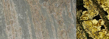
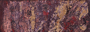
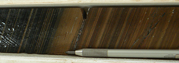
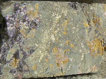
Figure 3 Alteration and mineralisation styles within Wallaroo Group, Punt Hill prospects. Photomicrographs and petrographic descriptions from Mason (2012).
Figure 3b Banded garnet–pyroxene–amphibole–sulfide skarn. Drillhole GHDD01, 932.3 m. Inset: Photomicrograph of drill core sample showing garnet (zoned brown to pale yellow) bands and interstices of amphibole (dark green) and sulfide (mostly black; chalcopyrite, sphalerite, galena). (Photos 416630, 416631)
Figure 3c Partly calcite–sulfide–hematite retrogressed, garnet–pyroxene–sulfide skarn. Drillhole GHDD1, 854 m. (Photo 416632)
Figure 3e Photomicrograph of drill core sample showing partly chlorite–calcite–hematite–sulfide retrogressed banded garnet–pyroxene skarn illustrating interstitial bornite (pinkish brown) and hematite (small pale grey crystals). Drillhole WPDD01, 844 m. (Photo 416634)
Methods
Geochemical, spectral and petrophysical data were acquired in the Punt Hill and Red Lake region using historical drillholes and drill core provided by Monax Mining, who also gave access to >$6 million worth of data collected during their tenure. Spectral scans of drill core, in the visible to thermal infrared wavelength range, were made using the HyLogger-3TM hyperspectral core scanner. These data enabled consistent and subjective drill core logging of mineralogy at centimetre scale. Selected sample intervals were analysed for 65 elements by inductively coupled plasma methods, and fluorine by specific ion electrode. Geochemical data was used to establish trace element associations with mineralisation and surrounding alteration. Both regional- and prospect-scale inversions of aeromagnetic and gravity data were generated to improve the understanding of the 3D distribution of magnetic susceptibility and density in the region. Magnetic susceptibility and density measurements were collected on drill core to provide petrophysical constraints and aid interpretation of the magnetic and gravity inversion models.
The co-location of sample intervals where possible enabled data to be integrated and relationships between data types to be investigated, e.g. relationships between geochemistry, mineralogy, lithology and petrophysical properties. Details of how each of these data were collected and integrated can be found in Fabris et al. (2018).
Project summary
Spectral mineralogy
Spectral logging of drill cores using the HyLogger-3TM enabled high spatial resolution downhole mapping of mineralogy in the Punt Hill region. Spectral mineralogy derived from HyLogger-3TM compared well with minerals identified in thin section (Mason 2012; Fabris et al. 2018). Spectral results from >3,000 m of skarn across the different prospects in the Punt Hill region indicate that garnet compositions are primarily andraditic with lesser grossular garnet. Pyroxene species are dominated by diopside and lesser augite and hedenbergite. Retrograde minerals identified spectrally include chlorite, talc, amphibole (hornblende), K-feldspar, white mica (muscovite and illite), carbonate (calcite and siderite), epidote, barite and hematite. There is only minor serpentine, rare magnetite (few holes only) and no known pyrrhotite or olivine. These mineral assemblages and compositions are consistent with an oxidised copper skarn classification (Einaudi and Burt 1982).
Skarn mineralogy can be used to interpret proximity to the source of hydrothermal fluids (Meinert 1992), which is vital for mapping a skarn system and predicting the likely location of mineralisation. Protolith composition imposes a primary control on the skarn assemblage and can complicate the interpretation of the mineralogy, where interpretation should be restricted to similar lithological units and along fluid flow paths. In an attempt to develop an internal stratigraphy within the Wallaroo Group which hosts the skarn alteration in the Punt Hill region, lithologies in more distal and less altered drillholes were used with correlation of observed mineralogy between closely spaced drillholes (particularly at Groundhog prospect). As a result, Wallaroo Group sediments (Wandearah Formation equivalent) in the region are interpreted to originally be composed of three broad units:
- variably calcareous sandstone and siltstone, over,
- a series of alternating silty carbonate and fine-grained, laminated carbonaceous units (now dominated by K-feldspar; Fig. 3d), over,
- dolomitic siltstone.
Copper mineralisation is mostly associated with the central, more calcareous units.
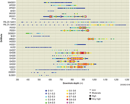
Using this primary lithology as context, garnet to pyroxene ratios were measured from spectral data. The results are presented in Figure 1 and Table 2, and give a likely vector towards the source of high temperature fluids or, in other words, causative intrusion.
Skarn systems are generally limited to within a few kilometres from an intrusive heat source (Meinert, Dipple and Nicolescu 2005). This necessitates Hiltaba Suite intrusions to be present in relatively close proximity to prospects in the Punt Hill region. Given Hiltaba-age units have not been observed in drill core, the implication is that they occur below or proximal to each group of prospects. Several possibilities have been interpreted based on residual gravity data and include the Red Lake region, beneath the Hoary prospect, and a more discrete body south of the Prairie Dog prospect (Fig. 1). To satisfy garnet:pyroxene ratios measured at each prospect, both the large gravity low in the south of the Punt Hill region and the smaller gravity low south of the Prairie Dog prospect are likely Hiltaba-age intrusions which have mobilised hydrothermal fluids up and along NW–SE-trending regional faults. In this scenario, the skarn mineralisation at Punt Hill represents relatively shallow alteration from fluids derived from these bodies.
Table 1 Relative garnet:pyroxene ratio gained from HyLogger-3TM spectral data at individual prospects in the Punt Hill region
| Prospect | Drillhole | Garnet:pyroxene* | Vector |
|---|---|---|---|
| Groundhog | GHDD7 | Gar>>pyx (5.30) | High temperature fluid source from south |
| GHDD5 | Gar>>pyx (4.42) | ||
| GHDD4 | Gar>>pyx (4.06) | ||
| GHDD3 | Gar>>pyx (4.04) | ||
| GHDD6 | Gar>pyx (2.82) | ||
| GHDD1 | Gar>pyx (2.18) | ||
| GHDD2 | Gar ≈ pyx (1.07) | ||
| Woodchuck | WDDD1 | Gar>pyx | High temperature fluid source from southwest |
| WDDD2 | Pyx>>gar | ||
| Whistle Pig | WPDD1 | Gar>pyx | High temperature fluid source from southeast |
| WPDD2 | Gar>>pyx | ||
| Prairie Dog | PDDD1 | Gar>>pyx | High temperature fluid source from southwest |
| PDDD2 | Gar ≈ pyx | ||
| Hoary | HODD1 | No garnet or pyroxene | High temperature fluid source from east |
| HODD3 | gar>>pyx |
* Measured ratios indicated in brackets for the GHDD series of drillholes were derived using ‘The Spectral Assistant’.
Geochemistry
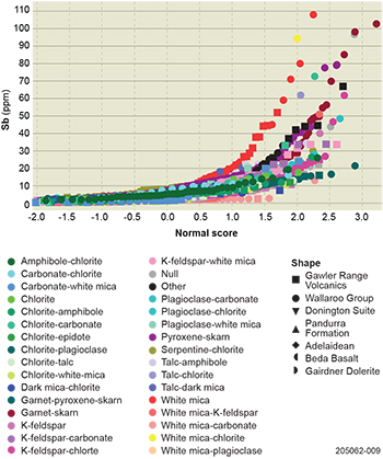
Figure 4 Probability plot for antimony showing that high values (>10 ppm) are associated with most alteration assemblages and within Gawler Range Volcanics and Wallaroo Group. Samples dominated by white mica alteration have the highest median antimony values.
Spectral mineralogy was used to map alteration mineralogy within drillholes, and also to characterise alteration assemblages of each drill core sample submitted for assay. The classification method is explained in Fabris et al. (2018), and enabled trace element relationships to specific alteration minerals and assemblages to be established. While copper mineralisation at Punt Hill was found to be associated with a diverse range of alteration minerals, it was most frequently associated with partially retrogressed samples containing amphibole and/or talc, commonly with garnet and/or pyroxene (Fig. 3).
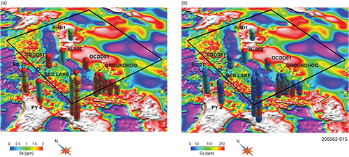
Elements associated with copper mineralisation in the Punt Hill region were Au, Ag, Cd, Co, Ni, Pb, S, Se, Te and Zn. In addition, the elements As, Bi, Ce, La, Mo, W and U have both highly anomalous values in the region and an association with prograde and retrograde mineral assemblages, and therefore relate to the mineralisation process. Interestingly, antimony values in the Punt Hill region are extremely high (commonly >100 x the average crustal abundance), but with high values related with a range of alteration assemblages and intensities, including a strong correlation with white mica-dominated alteration evident in both the Gawler Range Volcanics and Wallaroo Group (Fig. 4). This correlation with alteration minerals associated with weakly as well as intensely altered units supports it as a useful element for defining broad geochemical halos in the Punt Hill region (Fig. 5). Overall, based on the enrichment of elements correlated with copper mineralisation as well as surrounding alteration zones, key trace elements in the Punt Hill region include Au, Ag, As, Bi, Cd, Ce, Co, Cu, La, Mo, Ni, Pb, S, Sb, Se, U, W and Zn.
Figure 5 3D perspective view of drillholes in the Punt Hill region coloured by (a) antimony and (b) copper values overlaid on residual gravity. Antimony values are significantly high (>10 x the average crustal abundance) over a wide area and across a range of stratigraphic units. By comparison, the distribution of high copper values (>10 x the average crustal abundance) is more restricted.
Trace elements associated with mineralisation in the Punt Hill region were used to generate an index that estimates prospectivity (Fabris et al. 2018), where the index score is the sum of elements above a threshold, divided by the number of elements used in the calculation. Based on the prospectivity index, the most prospective drillholes include GHDD6, GHDD4, GHDD1, GHDD2, GHDD3, PDDD1, WDDD1, PDDD2, MMDD1 (in order of decreasing prospectivity). Moderate values were calculated for crystalline basement in drillholes GHDD5, OCDD 01, PRL 21 / SAR 8, WDDD2, WPDD2, WPDD1, HODD3, and are potential near-miss intersections. Spatially, highest values highlight the central Punt Hill region to include the Groundhog, Prairie Dog, Woodchuck and Marmot prospects (Fig. 6). In addition, moderate values also highlight the Otcheck, Red Lake, Whistle Pig and Hoary prospects.
Figure 6 Plot of the prospectivity index calculated from downhole geochemistry over solid geology for the Punt Hill region.
Relationship of petrophysical properties with stratigraphy, alteration and mineralisation
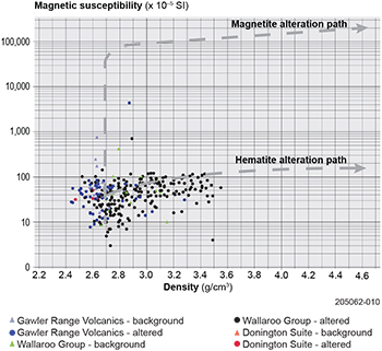
Petrophysical properties measured on drill core in the Punt Hill region (Fig. 7) indicate negligible magnetite (mostly <0.001 SI) content, and a range from average crustal densities (~2.67 g/cm3) to moderately high density values of ~3.5 g/cm3. The increase in density is a result of skarn alteration, and is primarily developed within Wallaroo Group. While significantly elevated, the density values are lower than those associated with hematite- or magnetite-dominated IOCG deposits (e.g. hematite-dominated IOCG deposits have density ranges of 2.7–4.5 g/cm3; Ehrig et al. 2012; Fabris et al. 2013).
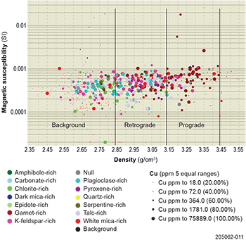
Observed relationships between magnetic susceptibility, density, mineralogy and copper values demonstrate that highest copper grades are most commonly associated with zones of low magnetic susceptibility, moderate density, and which record both prograde and retrograde alteration events, the latter event giving rise to lower density minerals such as talc, amphibole, chlorite and white mica (Fig. 8). These results suggest that targeting should be focused on regions having a combination of prograde and retrograde mineral assemblages and therefore not directly associated with peak gravity values.
Figure 7 Cross-plot of magnetic susceptibility versus density classified by stratigraphic units in the Punt Hill region. Data is limited to samples with measurements of both properties. Only Geological Survey generated petrophysical properties are shown.
Figure 8 Plot of density and magnetic susceptibility of drill core samples, Punt Hill region. Each sample is coloured using a simplified alteration classification scheme and sized by copper values. At Punt Hill, prograde altered rocks have a moderately high density in the range of approximately 3.1–3.4 g/cm3. Retrograde overprinted rocks have a density range of approximately 2.8–3.1 g/cm3. Reasonable discrimination is observed between prograde- and retrograde-dominated assemblages. Densities below 2.8 g/cm3 are considered to be background.
Inversion models
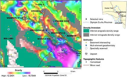
Figure 9 Density inversion results showing inferred prograde (green, ~3.10 to 3.40 g/cm3) and retrograde (grey, ~2.80 to 3.08 g/cm3) within the Wallaroo Group, Punt Hill region. Note: inversions are non-unique, therefore the inverted density data presented represent one of many possible density distributions.
Modelling of gravity and magnetic data was used to develop predictive maps of regions containing similar petrophysical properties to those measured in skarn alteration zones in drill core. Property value ranges within the inversion results tended to be lower than measured values. It was taken that the loss of density or magnetic susceptibility within the distribution was inherent in the inversion codes and prompted the technique of rescaling values to fit the range gained from measured density values. Alternative explanations include that petrophysical properties measured on drill core are not adequately representative of volumes modelled in inversions, or, that the background density of 2.67 g/cm3 used in the model was too high. Although it is uncertain whether rescaling of density and magnetic susceptibility values derived from the inversion results is valid, it produced geologically plausible models of inferred retrograde and prograde density distributions across the Punt Hill study area (Fig. 9). These modelled regions represent the location of rocks of similar properties to known skarn alteration and therefore can be used to predict the possible extension of mineralisation outside of that identified from drilling. Although inversion results are non-unique, extensive skarn alteration can be used to explain residual gravity highs in the Red Lake region (mostly prograde skarn) and the three NW–SE-trending gravity highs in the Punt Hill region (Fig. 1). Our models indicate that there are large areas of prospective ground that remain untested by drilling.
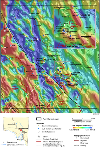
Figure 10 Residual aeromagnetic image of the Punt Hill study region. Dominant features include NW–SE- and NNW-orientated linear residual magnetic highs, and high magnitude and amplitude magnetic anomalies west of the Elizabeth Creek Fault. Most prospects are associated with residual magnetic anomalies.
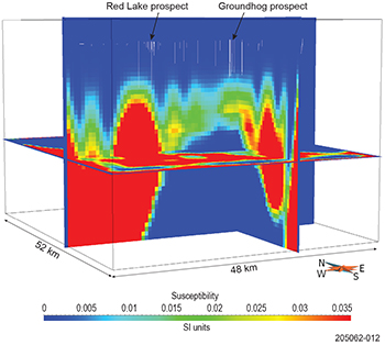
Petrophysical data from Punt Hill drill cores shows no indication of significantly elevated magnetic susceptibility within the mineralised zones, yet residual magnetic anomalies are present in the aeromagnetic data (Fig. 10). Magnetic susceptibility data captured from drill core places the highest magnetic susceptibility values in the Beda Basalt. However, the aeromagnetic data reveals discrete residual magnetic features, which is not consistent with the flat-lying Beda Basalt being the source of these features. The discrete magnetic anomalies are often coincident with residual gravity anomalies and are present at most of the mineralised sites drilled at Punt Hill, including Groundhog, Hoary, Woodchuck, Prairie Dog, Wiarton Willy and Marmot (Fig. 1). The exception is at the Whistle Pig prospect (drillholes WPDD1 and 2), where mineralisation was intersected in a magnetic low. While residual magnetic anomalies are one of the key targeting criteria in the Punt Hill region, no connection had previously been established between magnetic anomalism and mineralisation. Magnetic inversion results from this study model the magnetism as being sourced from beneath the Wallaroo Group (Fig. 11). The deeply sourced magnetism appears to represent magnetite growth along fluid pathways, with discrete anomalies at individual prospects associated with relatively shallow upflow zones of fluids (where fluids are magnetite-stable), with the skarn mineralisation at Punt Hill therefore representing the upper level alteration from these fluids. This result is significant as it demonstrates a genetic relationship to more traditional IOCG mineralisation, where early magnetite alteration is observed below the lower temperature and more oxidised part of the alteration system (Apukhtina et al. 2017). The implication is that in the right conditions (host rock, crustal depth, structural setting), other IOCG styles (breccia-hosted, hematite-dominated, magnetite-dominated) may also exist in the region.
Figure 11 Magnetic susceptibility inversion model for the Punt Hill region, looking northeast. The z plane of the model is located at 3,000 m depth. The x and y planes have been positioned to cut through the Groundhog prospect and show areas of increased magnetic susceptibility from ~1.3 km. Existing drillholes are displayed (white lines from surface). Base of model is at 5,240 m. Vertical exaggeration is 5 times. Areas in red represent values greater than 0.036 SI units.
Conclusion
The Punt Hill region is prospective for Cu–Au ± Pb–Zn skarn and IOCG style deposits, lying within the Olympic Cu–Au Province of the eastern Gawler Craton. To date, the most significant copper intersections have been associated with partly retrogressed zones within garnet–pyroxene skarn developed in Wallaroo Group metasediments. Mineralised zones typically include amphibole and/or talc, commonly with garnet and/or pyroxene, and have low magnetic susceptibility (mostly <0.001 SI) and moderate densities (2.7–3.3 g/cm3). The reduction in density associated with the retrograde alteration phase means that exploration targeting should be offset from peak gravity values.
Informed by measurements of magnetic susceptibility and density from Punt Hill drill cores, regions with similar properties to areas of known mineralisation were identified within gravity and magnetic inversion models. The modelling supports the existence of broad areas of skarn alteration in Wallaroo Group which remain to be tested by drilling.
Antimony was identified as an element that shows an association with both proximal and distal alteration minerals, and is a useful element for identifying kilometre-scale geochemical ‘footprints’ in the region. A geochemical index derived using elements associated with known mineralisation indicates that prospects in the central Punt Hill region, including Groundhog, Prairie Dog, Woodchuck and Marmot, have geochemical attributes that are most similar to that expected in a significant mineral system.
In addition to providing detailed characterisation of the mineralogy within the Punt Hill region, spectral mineralogy through the HyLoggerTM system enabled semi-quantitative estimation of the garnet to pyroxene ratio, which in skarn systems provides an indication of proximity to the source of hydrothermal fluids (temperature vector). When coupled with regional gravity data and magnetic inversion results, garnet to pyroxene ratios support a causative intrusion proximal but to the south of the Punt Hill prospects. These data support a mineralisation model where magmatic–hydrothermal fluids sourced from deep-seated Hiltaba Suite intrusions moved up NW–SE-trending faults in a generally northward direction and into calcareous strata, forming prograde skarn assemblages. Either cooled and evolved fluids, or a separate shallowly sourced fluid, resulted in retrograde alteration and Cu–Au ± Ag–Zn–Pb mineralisation.
Complete descriptions of results and interpretations are available in Fabris et al. (2018). Datasets have been incorporated into a 3D Gocad model which is the ideal method to view results of this project. This model serves as a 3D mineral potential map that displays components of mineral systems developed in the Punt Hill region down to ~5 km depth.
Acknowledgements
Spectral mineralogy was derived from HyLoggerTM technology which is supported by AuScope and the National Collaborative Research Infrastructure Strategy. Anthony Reid (Geological Survey of South Australia) provided a constructive review of this article.
References
Allen SR, McPhie J, Ferris G and Simpson C 2008. Evolution and architecture of a large felsic igneous province in western Laurentia: the 1.6 Ga Gawler Range Volcanics, South Australia. Journal of Volcanology and Geothermal Research 172:132–147.
Allen SR, Simpson C, McPhie J and Daly S 2003. Stratigraphy, distribution and geochemistry of widespread volcanic units in the Mesoproterozoic Gawler Range Volcanics, South Australia. Australian Journal of Earth Sciences 50:97–112.
Apukhtina OB, Kamenetsky VS, Ehrig K, Kamenetsky MB, Maas R, Thompson J, McPhie J, Ciobanu CL and Cook NJ 2017. Early, deep magnetite-fluorapatite mineralization at the Olympic Dam Cu-U-Au-Ag deposit, South Australia. Economic Geology 112:1531–1542.
Beyer SR, Kyser K, Polito PA and Fraser GL 2018. Mesoproterozoic rift sedimentation, fluid events and uranium prospectivity in the Cariewerloo Basin, Gawler Craton, South Australia. Australian Journal of Earth Sciences 65(3):409–426.
Ehrig K, McPhie J and Kamenetsky VS 2012. Geology and mineralogical zonation of the Olympic Dam iron oxide Cu-U-Au-Ag deposit, South Australia. In JW Hedenquist, M Harris and F Camus eds, Geology and genesis of major copper deposits and districts of the world: a tribute to Richard H Sillitoe, Special Publication 16. Society of Economic Geologists, pp. 237–268.
Einaudi MT, Meinert LD and Newberry RJ 1981. Skarn deposits. In BJ Skinner ed., Economic Geology seventy-fifth anniversary volume, 1905-1980. The Economic Geology Publishing Company, El Paso, Tex., pp. 317–391.
Einaudi MT and Burt DM 1982. Introduction – terminology, classification and composition of skarn deposits. Economic Geology 77:745–754.
Fabris AJ, van der Wielen S, Keeping T and Gordon G 2015. Geochemical footprints of IOCG deposits beneath thick cover: insights from the Olympic Cu-Au Province, South Australia. 27th International Geochemical Exploration Symposium, Tucson, Arizona USA. Association of Applied Geochemists.
Groves DIP, Bierlein FP, Meinert LD, and Hitzman MW 2010. Iron oxide copper-gold (IOCG) deposits through earth history: implications for origin, lithospheric setting, and distinction from other epigenetic iron oxide deposits. Economic Geology 105:641–654.
Jagodzinski EA 2005. Compilation of SHRIMP U-Pb geochronological data, Olympic Domain, Gawler Craton, South Australia, 2001-2003, Record 2005/20. Geoscience Australia, Canberra.
Mason DR 2012. Petrographic descriptions for rock samples from drillholes CDDD01, OCDD01, GHDD06, WDDD01, WPDD01, PDDD01 and HODD03, Punt Hill Project, South Australia. Mason Geoscience Pty Limited Report 3828. In GM Swain, DR Mason, DT Miller, I Stewart, GA Coopes and GM Ferris, Data release: Yeltacowie, Pernatty [Station] and Whittata (the Punt Hill IOCG Project), Joint annual reports, plus final report to expiry of EL 5774 Punt Hill, for the period 7/1/2012 to 6/1/2017, Open file Envelope 12280. Department of State Development, South Australia, Adelaide.
Meinert LD, Dipple GM and Nicolescu S 2005. World skarn deposits. In JW Hedenquist, JFH Thompson, RJ Goldfarb and JP Richards eds, Economic Geology 100th anniversary volume. Society of Economic Geologists, Littleton, CO, USA, pp. 299–336.
Meinert LD 1992. Skarns and skarn deposits. Geoscience Canada 19(4):145–162.
Preiss WV comp. 1987. The Adelaide Geosyncline — late Proterozoic stratigraphy, sedimentation, palaeontology and tectonics, Bulletin 53. Geological Survey of South Australia, Adelaide.
Reid AJ and Fabris A 2015. Influence of pre-existing low metamorphic grade sedimentary successions on the distribution of copper-gold mineralisation in the Olympic Cu-Au Province, Gawler Craton. Economic Geology 110:2147–2157.
Schwarz MP 2003. LINCOLN, South Australia, 1:250,000 Geological Series Explanatory Notes, sheet SI53-11. Geological Survey of South Australia, Adelaide.
Shelton KL 1983. Composition and origin of ore-forming fluids in a carbonate-hosted porphyry copper and skarn deposit: a fluid inclusion and stable isotope study of Mines Gaspe', Quebec. Economic Geology 78(3):387–421.
Skirrow RG, Bastrakov EN, Barovich K, Fraser GL, Creaser RA, Fanning CM, Raymond OL and Davidson GJ 2007. Timing of iron oxide Cu-Au-(U) hydrothermal activity and Nd isotope constraints on metal sources in the Gawler Craton, South Australia. Economic Geology 102:1441–1470.


