Part of a new system to deliver geology at multiple scales.
The Geological Survey of South Australia presently delivers statewide digital surface geology map data at fixed 1:100,000 and 1:2,000,000 scales via the South Australian Resources Information Gateway, SARIG. Over the past 20 years a number of higher resolution map datasets – at scales of less than 1:50,000 – have been produced as special purpose maps, or as part of modern mapping campaigns where data is captured digitally in the field and subsequently up-scaled and merged into the 1:100,000 dataset. Some of these datasets have been released previously as printed maps or PDF digimaps, or have been up-scaled and released as 1:100,000 scale map products.
Digital SA Geology is a new system in development by the Geological Survey that uses these datasets to deliver high-resolution map data across scales. In the interim, until that system is complete, the high-resolution datasets can be requested from Customer Services DEM.CustomerServices@sa.gov.au
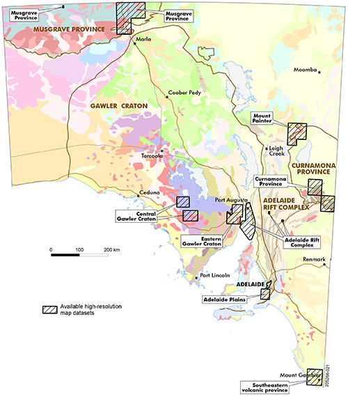
Available datasets include the Musgrave Province, central and eastern Gawler Craton, Mount Painter, Curnamona Province, Adelaide Plains, Adelaide Rift Complex and the southeastern volcanic province (Fig. 1). Locations are also shown in SARIG.
Figure 1 Preliminary high-resolution map datasets available across South Australia.
While all reasonable care has been taken to ensure these datasets are accurate, the data was often collected with a view to up-scale into the 1:100,000 layer, and is considered preliminary – eg there may be discrepancies with line work, annotation and labelling.
More information on individual datasets:
- Crooks AF 2001. Olary-Broken Hill Domain boundary - Mingary 1:100 000 map area, Report Book 2001/00008. Department of Primary Industries and Resources South Australia, Adelaide.
- Fabris A, Constable S, Conor C, Woodhouse A, Hore S and Fanning M 2005. Age, origin, emplacement and mineral potential of the Oodla Wirra Volcanics, Nackara Arc, central Flinders Ranges. MESA Journal 37:44–52. Department of Primary Industries and Resources South Australia, Adelaide.
- Fairburn WA and Cowley WM 2007. Surface geology of Adelaide City and eastern suburbs, Report Book 2007/00023. Department of Primary Industries and Resources South Australia, Adelaide.
- Fairburn WA, Preiss WV and Olliver JG 2010. Geology of the McLaren Vale wine region, Brochure 60. 2010 update. Department of Primary Industries and Resources South Australia, Adelaide.
- Krapf C, Pawley M, Werner M, Dutch R, Irvine J, Heath P and Hill S 2017. Boots on ground: release of the new ALCURRA 1:100,000 map in the eastern Musgrave Province. MESA Journal 84:4–9. Department of the Premier and Cabinet, Adelaide.
- McAvaney S, Krapf C, Werner M, Pawley M, Nicolson B and Irvine J 2017. Boots on ground: Six Mile Hill mapping provides new insights into the southern Gawler Craton. MESA Journal 82:20–30. Department of State Development, Adelaide.
- Werner M, Krapf C, Curtis S, Pawley M and Fabris A 2018. Boots on the ground: release of Peltabinna maps and explanatory notes, southwestern Gawler Ranges margin. MESA Journal 86:14–29. Department of the Premier and Cabinet, Adelaide.
– Rian Dutch, July 2020


