
SARIG’s latest tools and layers provide a one-stop shop to retrieve groundwater data.
The South Australian Resources Information Gateway (SARIG) has a new groundwater assessment theme to locate, identify and process groundwater data for a mining proposal and program for environment protection and rehabilitation (PEPR). Previously, groundwater-related data were accessible at 3 different websites without the ability to display all data on a single, unified map.
Groundwater plays an important role in sustaining aquatic and terrestrial ecosystems, such as some springs, wetlands, rivers and terrestrial vegetation. Understanding these groundwater-dependent ecosystems is essential for groundwater management and planning.
Under the Mining Act 1971 and Mining Regulations 2020, mining proposals and PEPRs are required to describe the existing environment and provide an assessment of the groundwater resources. If mining is proposed beneath or within 2 m of the seasonally high watertable, the potential impacts mining poses on groundwater-dependent ecosystems and other groundwater users are required to be addressed in the mining proposal and the PEPR.
The new groundwater layers are:
- Water wells (visible 1M)
- Groundwater monitoring networks – i.e. those water wells where depth to groundwater and/or salinity are monitored
- Aquatic - BoM Groundwater Dependant Atlas (GDE Atlas)
- Terrestrial - BoM Groundwater Dependant Atlas (GDE Atlas).
A complementary guide, Groundwater assessment using SARIG (PDF 15 MB), steps users through 4 common tasks:
- Task 1: Determine if a tenement is within a prescribed wells or prescribed water resources area.
- Task 2: Identify water well data adjacent to a tenement.
- Task 3: Identify groundwater-dependent ecosystems adjacent to a tenement.
- Task 4: Retrieving data. Provides a worked example of exporting raw data from SARIG (e.g. Microsoft Excel) for further analysis.
The example in Figure 1 shows Private Mine 115 and surrounding water wells, groundwater monitoring networks, and aquatic and terrestrial groundwater-dependent ecosystems.
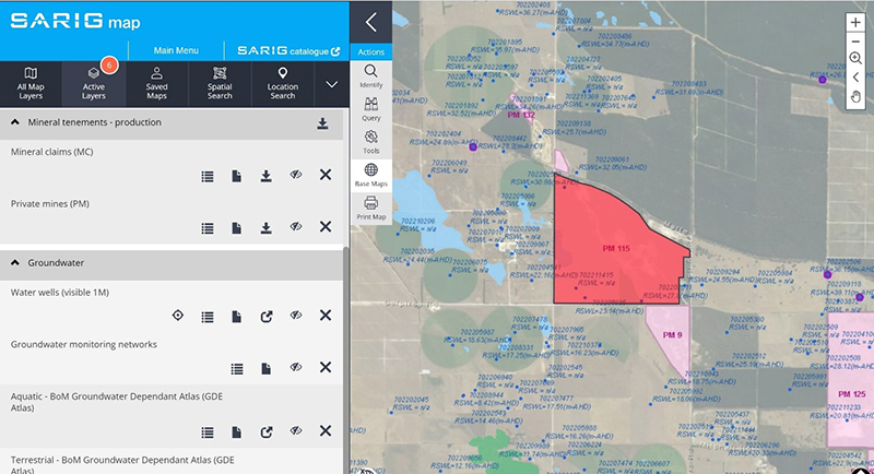
Figure 1 SARIG map showing selected groundwater assessment theme layers near a mining tenement.
Development of the groundwater assessment theme was achieved by cooperation with the Department for Environment and Water and the Bureau of Meteorology.
- View the groundwater assessment theme in SARIG.
- Alternatively, navigate to it from the SARIG home page. Select Land & Water Management and Groundwater assessment.
- Download the guide Groundwater assessment using SARIG (PDF 15 MB).
- Email DEM.CustomerServices@sa.gov.au for assistance.
– Gabor Bekesi and Christie Gerrard, July 2022