
Reprocessed 2D and 3D data
Commencing in 2019, TGS has been reprocessing South Australia’s extensive open-file 2D seismic database over the Cooper Basin, using their 2Dcubed technology to generate Pre-Stack Depth Migrated 2D and pseudo-3D outputs over the basin. Field data from 3,855 lines of 2D seismic data acquired between 1985 and 2012 were used as inputs into the study, which was undertaken with the support of Chevron Australia Pty Ltd. The area covered by the reprocessing is shown in the maps below.
Two PrSDM data-packages in ERD’s standardised workstation-ready format can be downloaded using the links below. In both cases, the supplied full-offset final volume (approximately 420Gb and 340Gb) has been split into 10 parts to allow for easier downloading and manipulation in interpretation software. The first package contains full-offset PrSDM SEGY data for the 2Dcubed (pseudo-3D) volume. The second package contains full-offset SEGY data for the merged 2D-3D PrSDM volume i.e. the pre-existing full-offset final data from the various 3D seismic surveys within the area-of-interest has been merged into the pseudo-3D PrSDM volume generated from the 2D lines. Angle-stacks, Velocity cube and Time-domain 3D volumes are available separately on request.
The 2Dcubed dataset is a great product for a regional understanding of the subsurface geology of the Cooper Basin. Note that the statics solution used in 2Dcubed, derived from a combination of uphole data and first break picking, has resulted in some smearing and smoothing of structures in the interpolation processing, with lower resolution in some instances. Consequently, 2Dcubed products should be used in a regional context and not for detailed mapping for the drilling of prospects.
Cooper Basin 2Dcubed data
TGS presentation outlining the processing workflow and guidelines used for the generation of the 2Dcubed data.
Maps and downloads
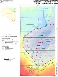
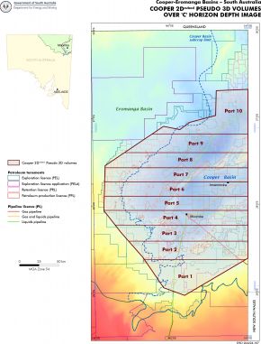
Figures showing locations of Parts 1-10 for Cooper 2Dcubed Pseudo PrSDM 3D (left) and Merged PrSDM 2D-3D (right) volumes over 'C' horizon depth image. Note that the 2D-3D merged Volumes 2-5 inclusive extend slightly into south-west Queensland due to the inclusion of the Snowball 3D.
Cooper 2Dcubed – Pseudo PrSDM 3D Volumes
Data descriptions and downloads
Cooper 2Dcubed – Merged PrSDM 2D-3D Volumes
Data descriptions and downloads
Spatial data
Commencing in 2019, TGS has been reprocessing South Australia’s extensive open-file 2D seismic database over the Cooper Basin, using their 2Dcubed technology to generate Pre-Stack Time Migrated and Pre-Stack Depth Migrated 2D and pseudo-3D outputs over the basin. Field data from 3855 lines of 2D seismic data acquired between 1985 and 2012 were used as inputs into the study, which is being undertaken with the support of Chevron Australia Pty Ltd. The area covered by the reprocessing is shown in the map below.
The 2D Pre-Stack Depth-Migrated data can be downloaded in ERD’s standardised workstation-ready format using the links below. The Department expects that the pseudo-3D PrSDM volumes will be published early in 2023.
Cooper Basin 2Dcubed data
TGS presentation outlining the processing workflow and guidelines used for the generation of the 2Dcubed data.
Downloads

Area in the Cooper Basin covered by the reprocessing
In 2021, Geoscience Australia began to reprocess selected 2D seismic lines from the Simpson-Pedirka Basins as part of the Exploring For The Future program. In Phase One, 34 legacy 2D seismic lines from the Pedirka Basin were reprocessed between May 2021 and January 2022. An additional 54 legacy 2D seismic lines (34 lines from Pedirka Basin, South Australia and 20 lines from Simpson Basin, Northern Territory) were reprocessed between November 2021 and June 2022 (Phase Two). The data has now been published by Geoscience Australia.
Commencing in 2019, TGS has been reprocessing South Australia’s extensive open-file 2D seismic database over the Cooper Basin, using their 2Dcubed technology to generate Pre-Stack Time Migrated 2D and pseudo-3D outputs over the basin. The final 2D PrSTM data was published in June and the pseudo-3D PrSTM outputs are now available for download. In addition, the ongoing Phase 2 of the project will deliver Pre-Stack Depth Migration (PrSDM) products in late 2022 or early 2023. Field data from 3,855 lines of 2D seismic data acquired between 1985 and 2012 were used as inputs into the study, which was undertaken with the support of Chevron Australia Pty Ltd. The area covered by the reprocessing is shown in the map below.
Two PrSTM data-packages in ERD’s standardised workstation-ready format can be downloaded using the link below. In both cases, the supplied full-offset final volume (approximately 160 GB) has been split into 10 parts to allow for easier downloading and manipulation in interpretation software. The first package contains full-offset PrSTM SEGY data for the 2Dcubed (pseudo-3D) volume. The second package contains full-offset SEGY data for the merged 2D-3D PrSTM volume i.e. the pre-existing full-offset final data from the various 3D seismic surveys within the area-of-interest has been merged into the pseudo-3D PrSTM volume generated from the 2D lines. Angle-stacks, velocity data and statics data are available separately on request.
The 2Dcubed dataset is a great product for a regional understanding of the subsurface geology of the Cooper Basin. Note that the statics solution used in 2Dcubed, derived from a combination of uphole data and first break picking, has resulted in some smearing and smoothing of structures in the interpolation processing, with lower resolution in some instances. Consequently, 2Dcubed products should be used in a regional context and not for detailed mapping for the drilling of prospects.
Cooper Basin 2Dcubed data
TGS presentation outlining the processing workflow and guidelines used for the generation of the 2Dcubed data.
Maps and downloads

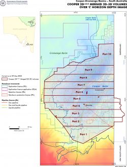
Figures showing locations of Parts 1-10 for Cooper 2Dcubed Pseudo 2D (left) and Merged 2D-3D (right) volumes over 'C' horizon depth image. Note that the 2D-3D merged Volumes 2-5 inclusive extend slightly into south-west Queensland due to the inclusion of the Snowball 3D.
Cooper 2Dcubed – Pseudo 3D Volumes and Merged 2D-3D Volumes
Data descriptions and downloads
Spatial data
Cooper Basin 2Dcubed seismic reprocessing – polarity-corrected 2D PrSTM lines available for download – June 2022
Commencing in 2019, TGS has been reprocessing South Australia’s extensive open-file 2D seismic database over the Cooper Basin, using their 2Dcubed technology to generate Pre-Stack Time Migrated and Pre-Stack Depth Migrated 2D and pseudo-3D outputs over the basin. Field data from 3855 lines of 2D seismic data acquired between 1985 and 2012 were used as inputs into the study, which is being undertaken with the support of Chevron Australia Pty Ltd. The area covered by the reprocessing is shown in the map below.
Earlier in 2022, an error in the processing sequence was noticed. The input multi-survey field data was recorded in a mix of SEG-positive and SEG-negative polarities. In order to comply with the standard (SEG-negative) polarity convention used in South Australia whereby an increase in impedance plots as a zero-phase trough, the polarity of any lines which were recorded using SEG-positive polarity (i.e. where an increase in impedance plots as a peak) should have been flipped during the creation of the final SEGY outputs. However, this step was not actually applied where needed and hence the polarity of some of the original published data was wrong.
TGS has now delivered the polarity-corrected 2D Pre-Stack Time-Migrated data. Full-offset stacks, velocity data and statics data for all 2D lines are available in one package and angle-stacks are provided separately. All data can be downloaded in ERD’s standardised workstation-ready format using the links below. Download links for the 2Dcubed (pseudo-3D volumes) are available separately.
Cooper Basin 2Dcubed data
TGS presentation outlining the processing workflow and guidelines used for the generation of the 2Dcubed data.
Downloads
Area in the Cooper Basin covered by the reprocessing
In 2021, Geoscience Australia commenced the reprocessing of selected 2D seismic lines from the Officer Basin as part of the Exploring For The Future program. The data has now been published by Geoscience Australia and can be accessed via the links below:
- Officer Basin Reprocessed deep crustal 2D seismic data package – 5 lines (approximately 550 km)
- Officer Basin Reprocessed industry 2D seismic data package – 25 lines (approximately 1,425 km)