
Summary
| PLAY | Poolowanna Formation |
| SOUTH AUSTRALIA BASIN | Eromanga |
| LOCATION | Poolowanna Trough region |
| AGE | Early-Middle Jurassic |
| RESERVOIR | Poolowanna Fm. sandstone |
| SEAL | Lower Poolowanna Fm. intraformational shales and coals |
| SOURCE ROCK/S | Lower Patchawarra Fm., Peera Peera Fm., Purni Fm. |
| HYDROCARBON PHASE | Oil |
| PRODUCTION | NONE; oil recovered in Poolowanna 1 (flowed 4 barrels of oil to surface in 4 hours, equating to a theoretical flow rate of 96 BOPD) |
| HYDROCARBON FLOW RATES | Water recovered in Mokari 1 at a rate of 387 cu ft/hr, equating to a rate of 1,654BWPD. Water flowed at 575BPD in Macumba 1 |
| POTENTIAL RESOURCES | ERD estimate June 2006 (Morton and Hill, 2007): 50% probability of 0.6 x 10⁶ kL (3.8 mmbbl) in Western Eromanga Basin |
Related papers
- Play analysis in the Pedirka Basin-Poolowanna Trough region (PDF 10 MB)
Paul Strong, Geological Survey of South Australia, Department for Energy and Mining
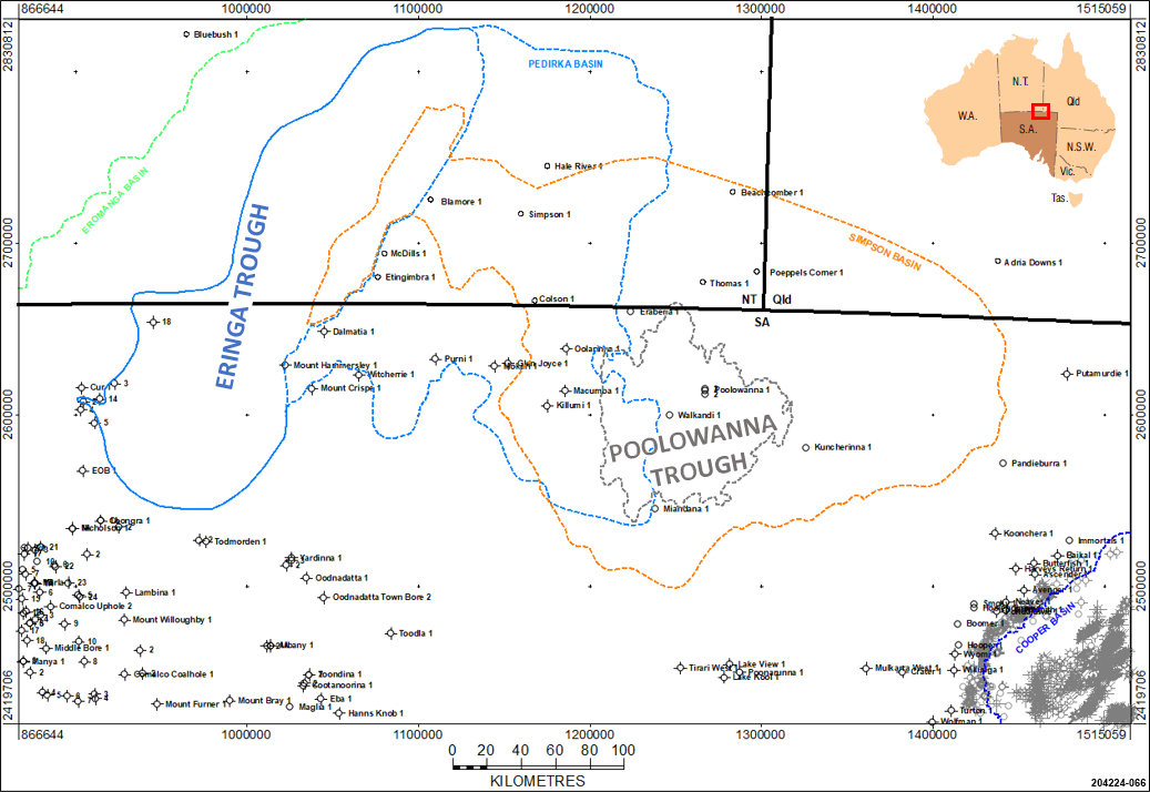
Location of the Poolowanna Trough within the Simpson and Pedirka Basins in central Australia.
The Eromanga Basin covers 1,000,000 km2 of central–eastern Australia, 360,000 km2 of which lies in South Australia. The Eromanga Basin encloses the multi-aquifer system of the Great Artesian Basin.
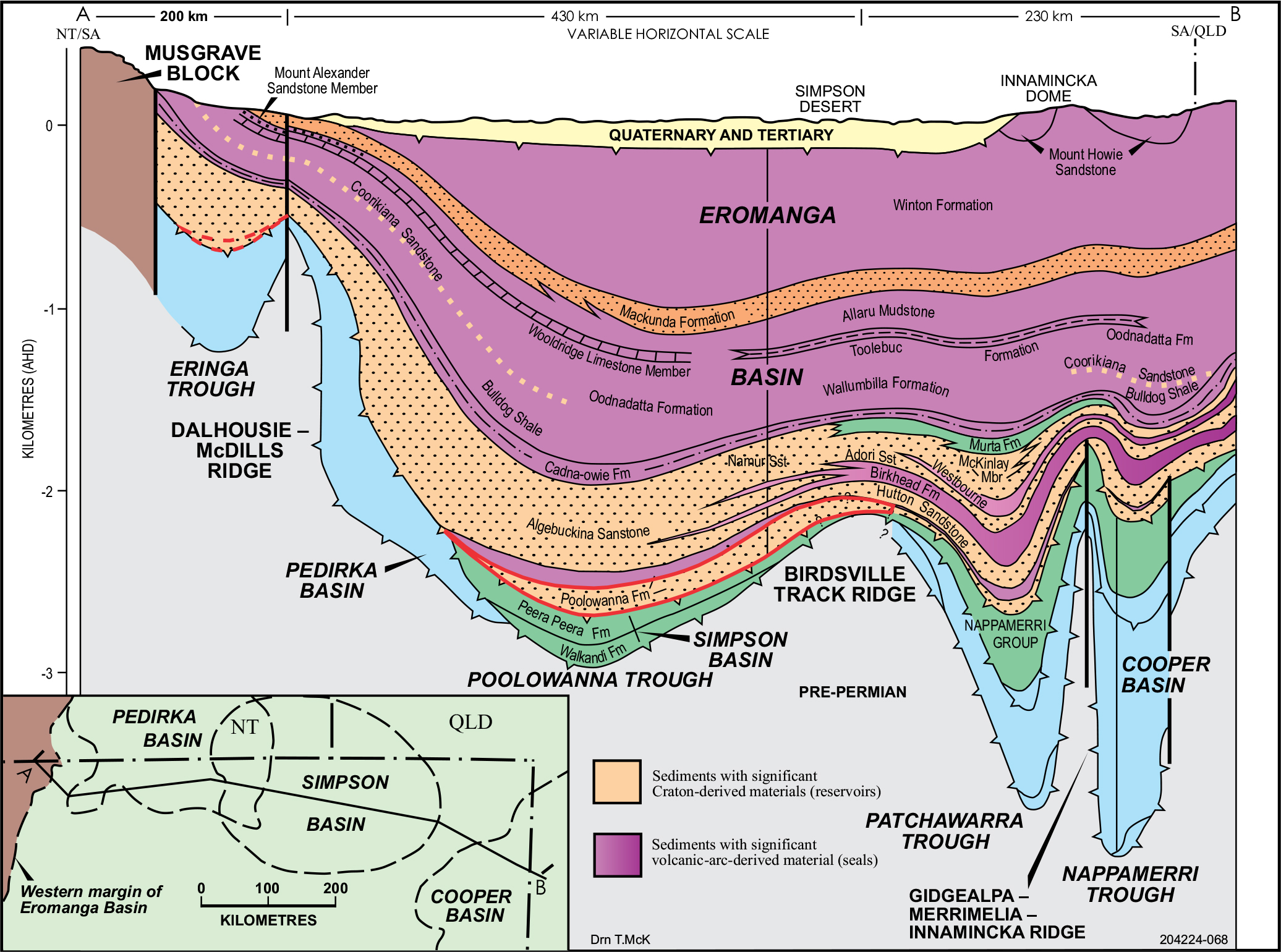
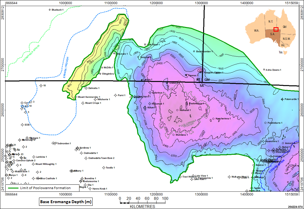
In South Australia, the Eromanga Basin overlies late Palaeozoic and older basins. It consists of a broad downwarp with two main depocentres separated by the NE-trending Birdsville Track Ridge — the Poolowanna Trough and the Cooper region — containing up to 3000m of sediment. The central Eromanga Basin is overlain by the Tertiary to Recent Lake Eyre Basin. Eromanga Basin units crop out extensively on the western and southern margins. The Poolowanna Trough in the NW contains a thick sand-dominated sequence in comparison to the Cooper region where intercalated shale and siltstone units occur.
Alexander et al (2007) discussed deposition of the Poolowanna at the commencement of the Eromanga Basin being controlled by subsidence rates and plate tectonic events on the margins of the Australian Plate, with activity on the eastern Australian volcanic arc influencing sediment provenance and depositional environment. The interpreted depositional environment was one of high-sinuosity fluvial channels meandering across a floodplain with minor coal swamps. In the Cooper region, palaeotopography on the Late Triassic unconformity surface strongly controlled Poolowanna facies, with a large northerly palaeovalley directed towards the Poolowanna Trough. Ravinement surfaces on the sides of palaeohighs are interpreted from wireline log data.
The Poolowanna Formation is Early Jurassic in age and is the oldest interval within the Eromanga Basin. It was deposited under non-marine conditions, and consists predominantly of sandstone with shales and coals. In the Poolowanna Trough, the Poolowanna Formation is up to 200m thick consisting of 2 depositional cycles.
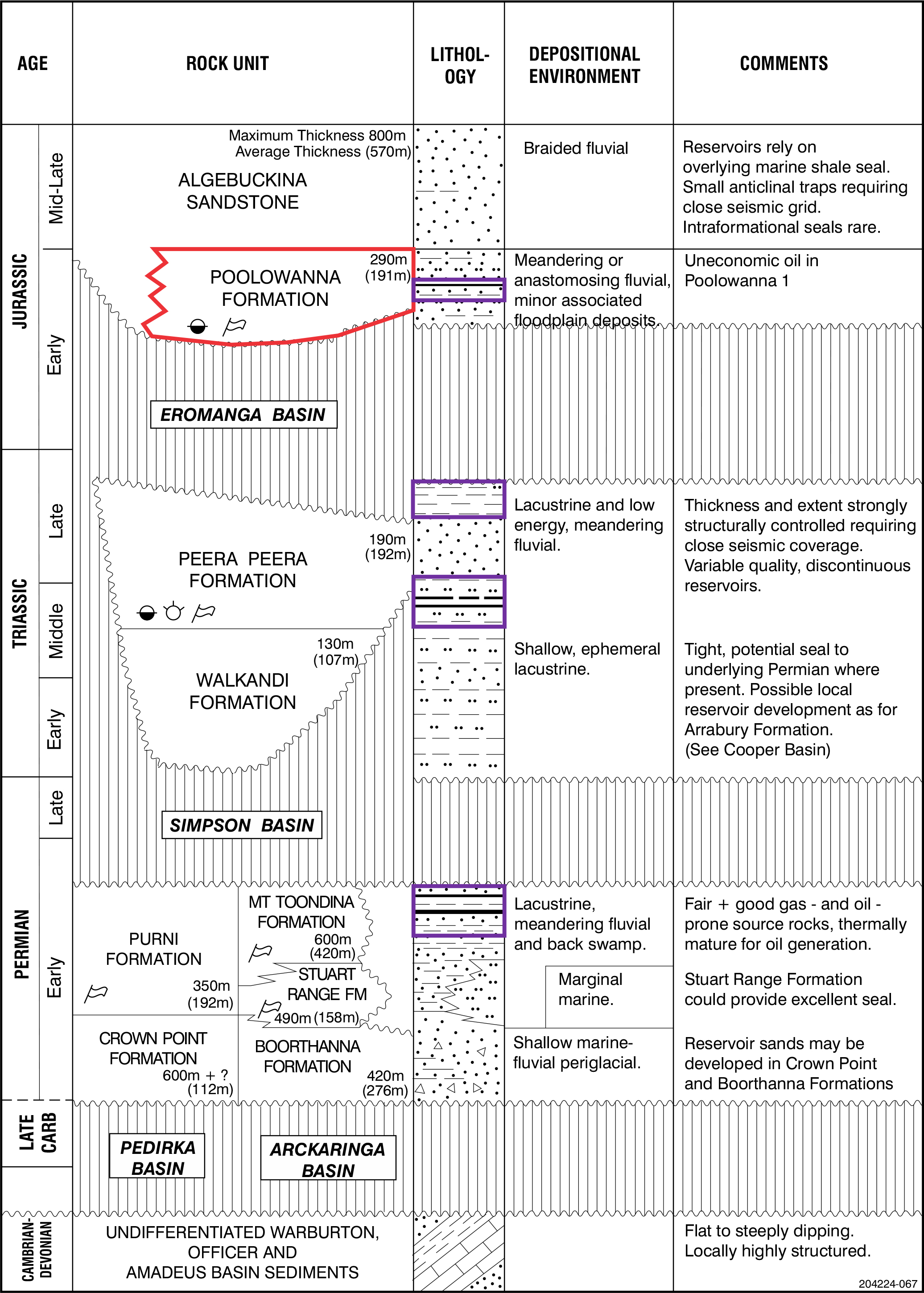
Geological summary of the Arckaringa, Pedirka and Simpson basins. Poolowanna Formation is highlighted in red and potential source rocks highlighted in purple.
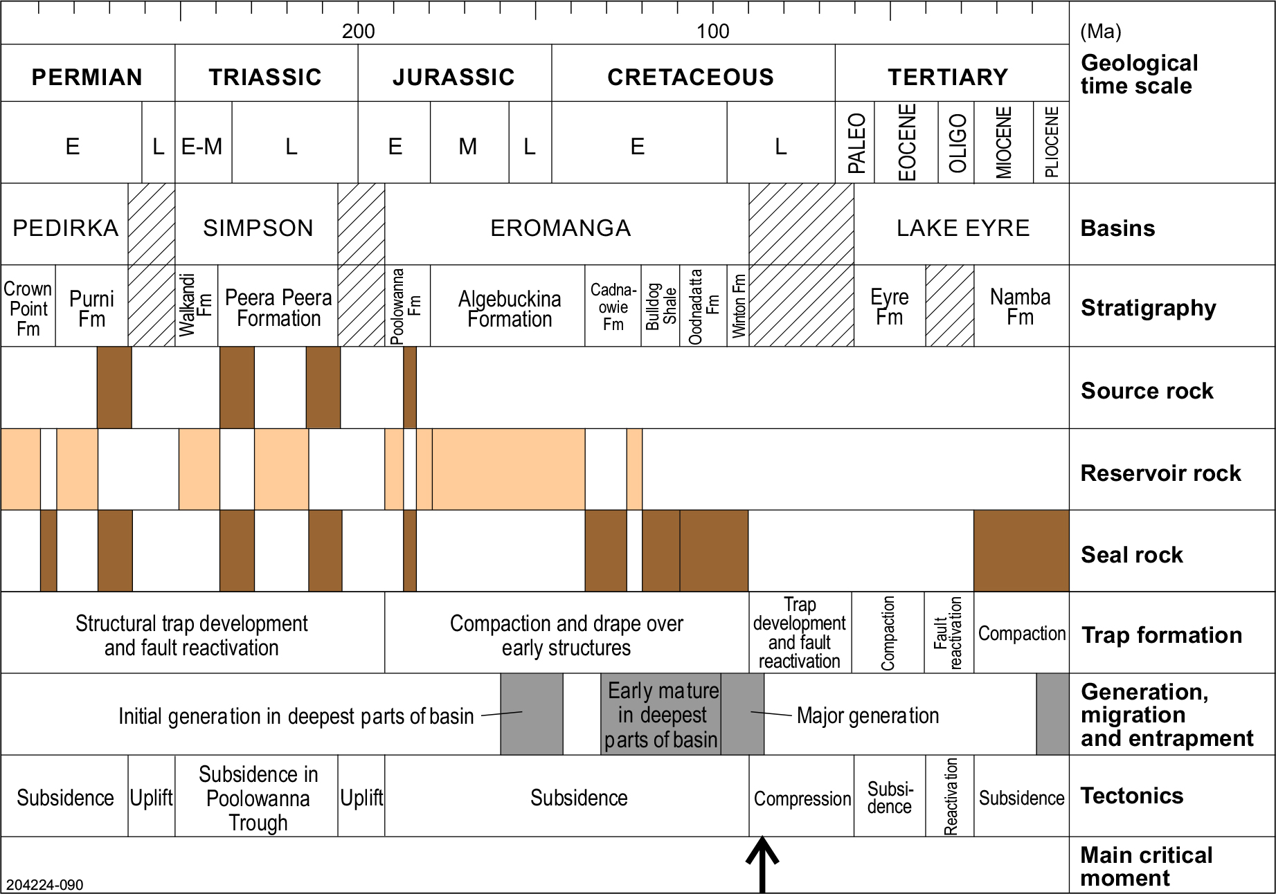
Key petroleum system events in the Pedirka Basin/Simpson Basin/Poolowanna Trough area
The key petroleum events chart for the Pedirka Basin/Simpson Basin/Poolowanna Trough area is similar to that for the Cooper-Eromanga Basins in that the critical moment was in the Late Cretaceous at the end of deposition of the Winton Formation, the last stage of the Eromanga Basin prior to uplift and erosion. Basin modelling suggests that major hydrocarbon generation and expulsion commenced around 100 Ma (Ambrose et al, 2007) and lasted around 10-15Ma, so formation of structures prior to this was critical.
Structural reactivation occurred in the Miocene, and it is likely that this breached seals for some hydrocarbon accumulations where fault seal was critical, which is likely to have been the case at Poolowanna 1. Therefore, exploration is required of more subtle structures not affected by the reactivation in the Miocene.
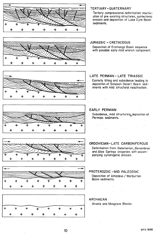
Schematic structural history of the Pedirka Basin-Poolowanna Trough area (Giuliano, 1988)
Petroleum exploration commenced in the 1950s when licences covering the Cooper and Eromanga basins were first acquired by Santos, who went against conventional wisdom that commercial accumulations of oil would not be found in Mesozoic formations within the Great Artesian Basin.
Initial exploration involved surface mapping, stratigraphic drilling, aerial surveys, gravity and aeromagnetic surveys and seismic. The first petroleum well was drilled in 1959 and Cooper Basin gas was discovered in 1963.
The first commercial hydrocarbon to flow from the Eromanga Basin was gas produced from Namur 1 in 1976 (Cooper region). Oil was discovered in 1977 with uneconomic flows of oil from basal Jurassic and Triassic sediments in Poolowanna 1 in the Poolowanna Trough. The first economic oil flow was recorded from Strzelecki 3 (Cooper region) in the following year and this stimulated a major oil exploration program.
Exploration activity intensified in the Poolowanna Trough/Pedirka Basin area in the 1980s in response to the Poolowanna discovery. Six seismic surveys were carried out and five wells were drilled, three in 1985 and two in 1988.
Seismic reinterpretation by Santos indicated that five of the previously drilled wells were not valid structural tests being outside closure at all objectives. Of the 1985 wells, Oolarinna 1 had no independent fault closure and Glen Joyce 1 had little closure.
It should be noted that no wells have been drilled in the South Australian sector since the 1980s, although Central Petroleum drilled Blamore 1 and Simpson 1 in the Northern Territory in 2008. Exploration in the area would benefit from current ideas on the geology of the petroleum systems in the Cooper Basin region and modern technology and interpretation techniques.
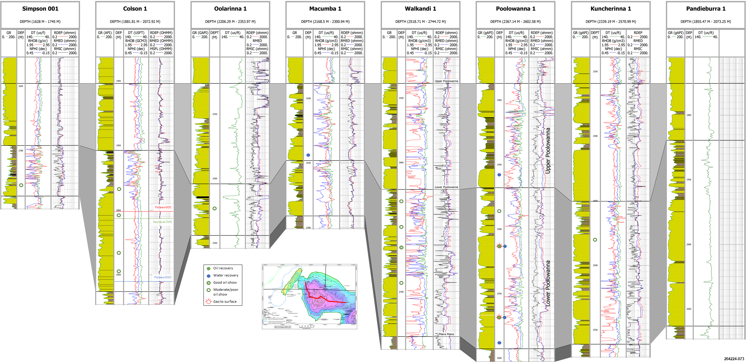
Hydrocarbon shows have been recorded in a number of wells within the Poolowanna Trough region, most significantly within the Poolowanna Formation. However, oil and gas has been recovered from only 2 wells, the Poolowanna and Peera Peera Formations in Poolowanna 1, and the Poolowanna Formation in Poolowanna 3.
The classification scheme used by Geoscience Australia has been used to determine the type of show present in a formation.
Hydrocarbon shows and flow rates in South Australian wells in the Poolowanna Trough/Simpson Basin/Pedirka Basin region:
| Well | Year/Result | Formation | Shows/Recovery | Flow rate |
|---|---|---|---|---|
| Pandieburra 1 |
1963 Oil shows | Peera Peera (?) | Minor fluorescence | |
| Dullingari Group | Minor fluorescence. Recovered 190ft mud-cut water with a trace of hydrocarbons. | |||
| Mokari 1 |
1966 Dry hole | Poolowanna | Gas show; mudlog gas 14 times background. Minor fluorescence. Water to surface (WTS) in 12 mins. | 387 cu ft/hr = rate of 1,654BWPD |
| Purni | Minor fluorescence. WTS in 17 mins. | Reported rate of 387 cu ft/hr | ||
| Poolowanna 1 |
1977 Oil shows | Poolowanna | Gas to surface (GTS) in 125 mins. Oil and water to surface in 3hrs 55 mins. Recovered 71¼ barrels water and 9½ barrels oil, 36.9o API gravity, with pour point of 41o C. | Gas at rate too small to measure (RTSTM). Calculated flow rate of 96BOPD |
| Peera Peera | Oil show. GTS in 120mins. Recovered 110ft mud and condensate. | Gas at RTSTM | ||
| Walkandi 1 |
1981 Oil shows | Poolowanna | Oil shows. Recovered 650ft muddy water and 1450ft gas-cut slightly muddy water. | |
| Peera Peera | Oil shows. Recovered 46ft rat hole mud and 31ft slightly gas-cut mud. | |||
| Walkandi | Oil shows. Recovered 480ft water cushion and 4900ft slightly gas-cut mud. | |||
| Erabena 1 |
1981 Oil shows | Poolowanna | Minor fluorescence | |
| Peera Peera | Minor fluorescence | |||
| Kuncherinna 1 |
1981/2 Oil shows | Poolowanna | Recovered 90ft rathole mud with trace of oil | |
| Peera Peera | Minor fluorescence | |||
| Poolowanna 2 |
1985 Oil shows | Wallumbilla | Minor fluorescence | |
| Cadna-owie | Minor fluorescence | |||
| Algebuckina | Minor fluorescence | |||
| Poolowanna | Minor fluorescence. Recovered 1026ft VSGCMW, 306ft SGCM. | |||
| Peera Peera | Minor fluorescence. Recovered 240ft very slightly gas-cut muddy water. | |||
| Oolarinna 1 |
1985 Dry hole | Poolowanna | Minor fluorescence | |
| Peera Peera | Recovered 5310ft gas-cut water (slightly muddy at top) | |||
| Killumi 1 |
1985 Dry hole | Poolowanna | Minor fluorescence | |
| Miandana 1 |
1985 Oil shows | Poolowanna | Minor fluorescence | |
| Poolowanna 3 |
1989 Oil shows | Algebuckina | Minor fluorescence | |
| Poolowanna | Minor fluorescence. GTS in 141 mins. Recovered 5550ft slightly oil and gas-cut water and 2290ft water in 171 mins. | Gas at RTSTM. 80BWPD. | ||
| Peera Peera | Minor fluorescence |
Hydrocarbon shows in Northern Territory wells in the Poolowanna Trough/Simpson Basin/Pedirka Basin region:
| Well | Year/Result | Formation | Shows/Recovery |
|---|---|---|---|
| McDills 1 | 1965 Trace hydrocarbon indication | Purni | Minor fluorescence |
| Colson 1 | 1978 Trace hydrocarbon indication | Poolowanna | Minor fluorescence |
| Peera Peera | Minor fluorescence | ||
| Warburton | Log interpretation “oil show” | ||
| Thomas 1 | 1981 Oil indication | Poolowanna | Residual oil. Recovered 4951ft water with minor mud in 68 mins. |
| Poeppels Corner 1 | 1984 Trace hydrocarbon indication | Algebuckina | Minor fluorescence |
| Poolowanna | Minor fluorescence | ||
| Peera Peera | Minor fluorescence | ||
| Beachcomber 1 | 1988 Trace hydrocarbon indication | Cadna-owie | Minor fluorescence in coals |
| Algebuckina | Minor fluorescence in coals | ||
| Peera Peera | Minor fluorescence in coals | ||
| Blamore 1 | 2008 Oil and gas show | Algebuckina | Residual oil |
| Walkandi | Minor fluorescence | ||
| Purni | Gas shows in coals. Trace fluorescence. | ||
| CBM 93 1 | 2008 Trace hydrocarbon indication | Purni | Minor fluorescence |
| Simpson 1 | 2008 Trace hydrocarbon indication | Poolowanna | Minor fluorescence |
| Walkandi | Minor fluorescence |
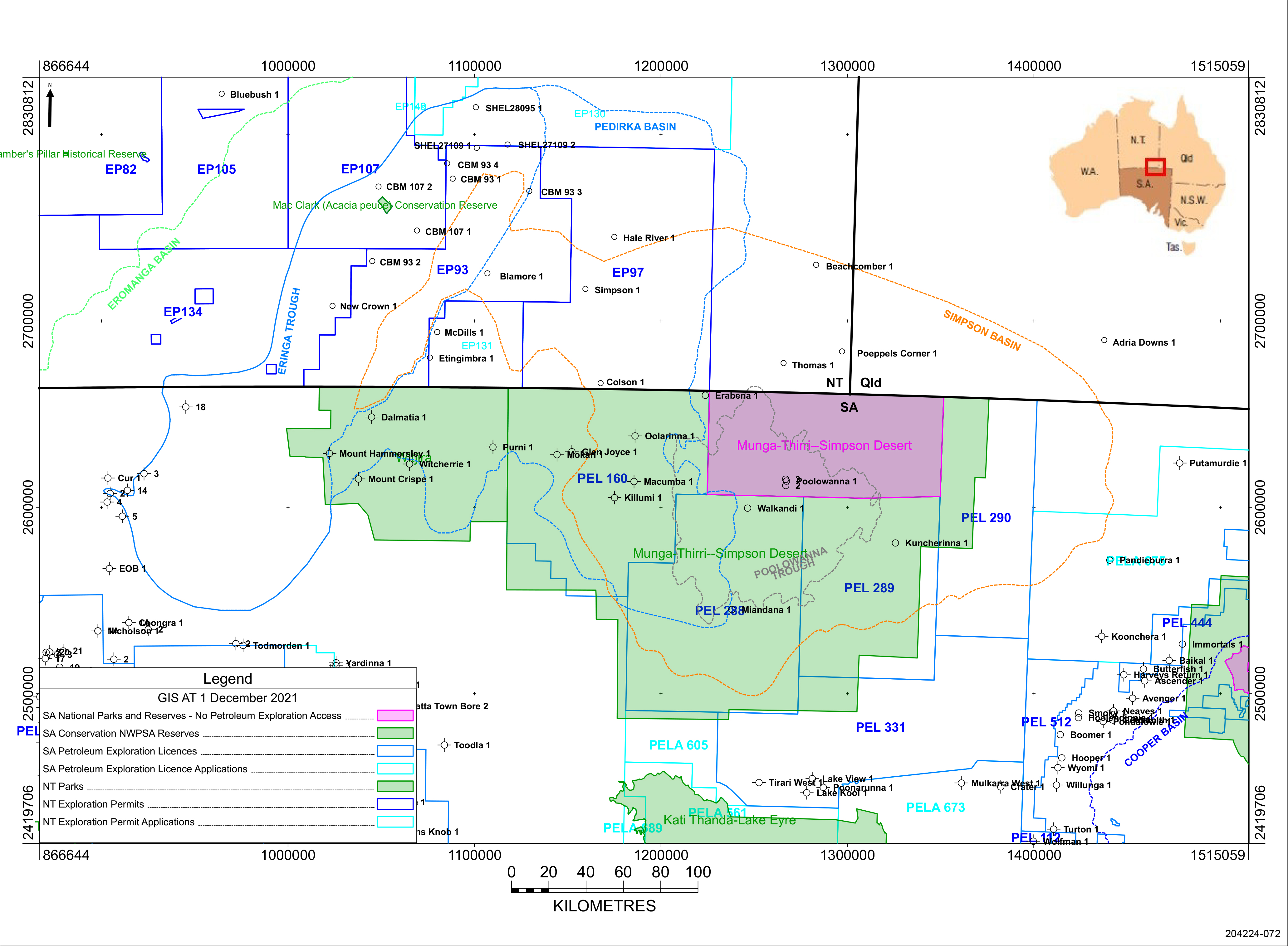
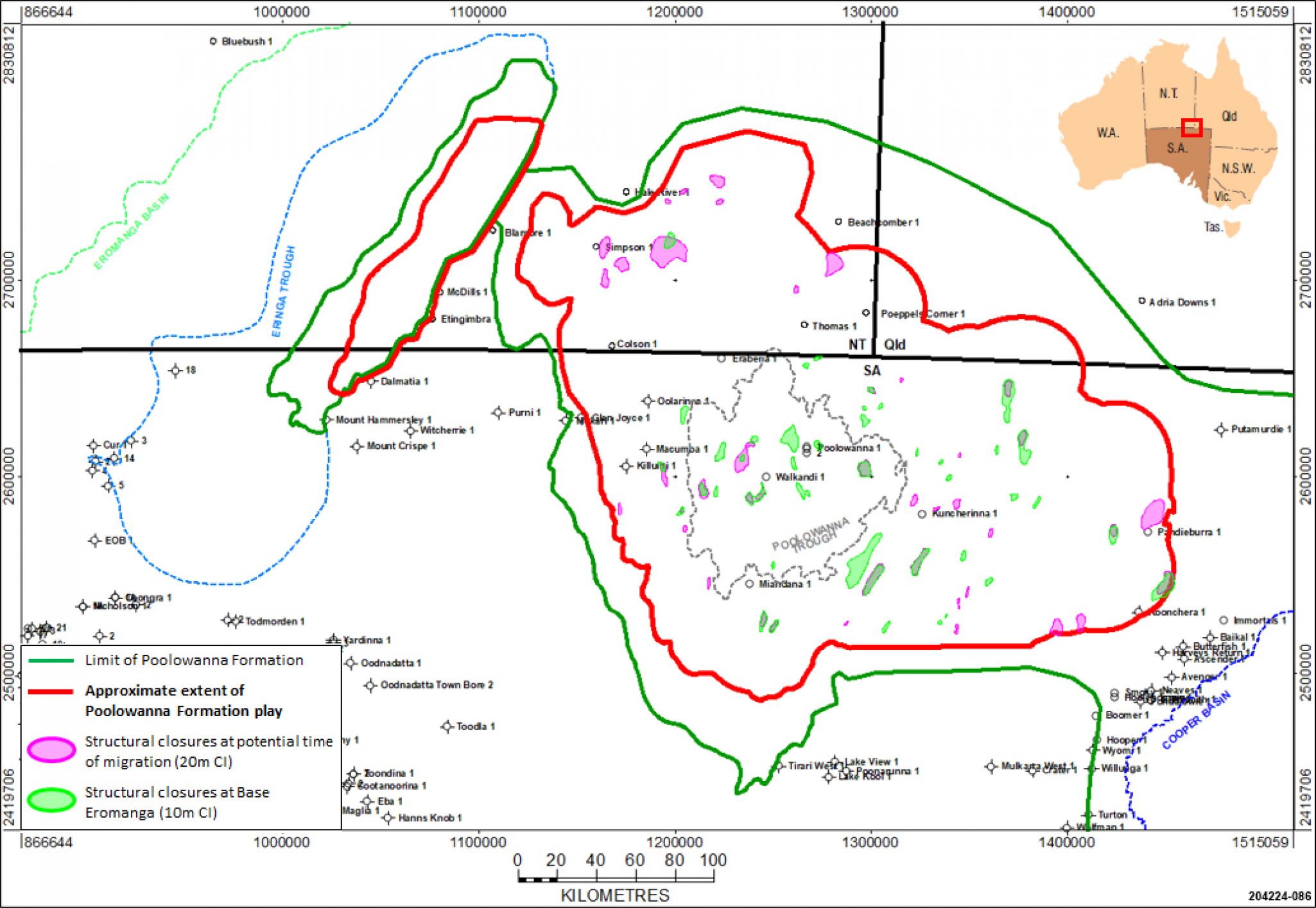
Petroleum exploration permits, regional reserves and conservation parks in the Poolowanna Trough area as at December 2021
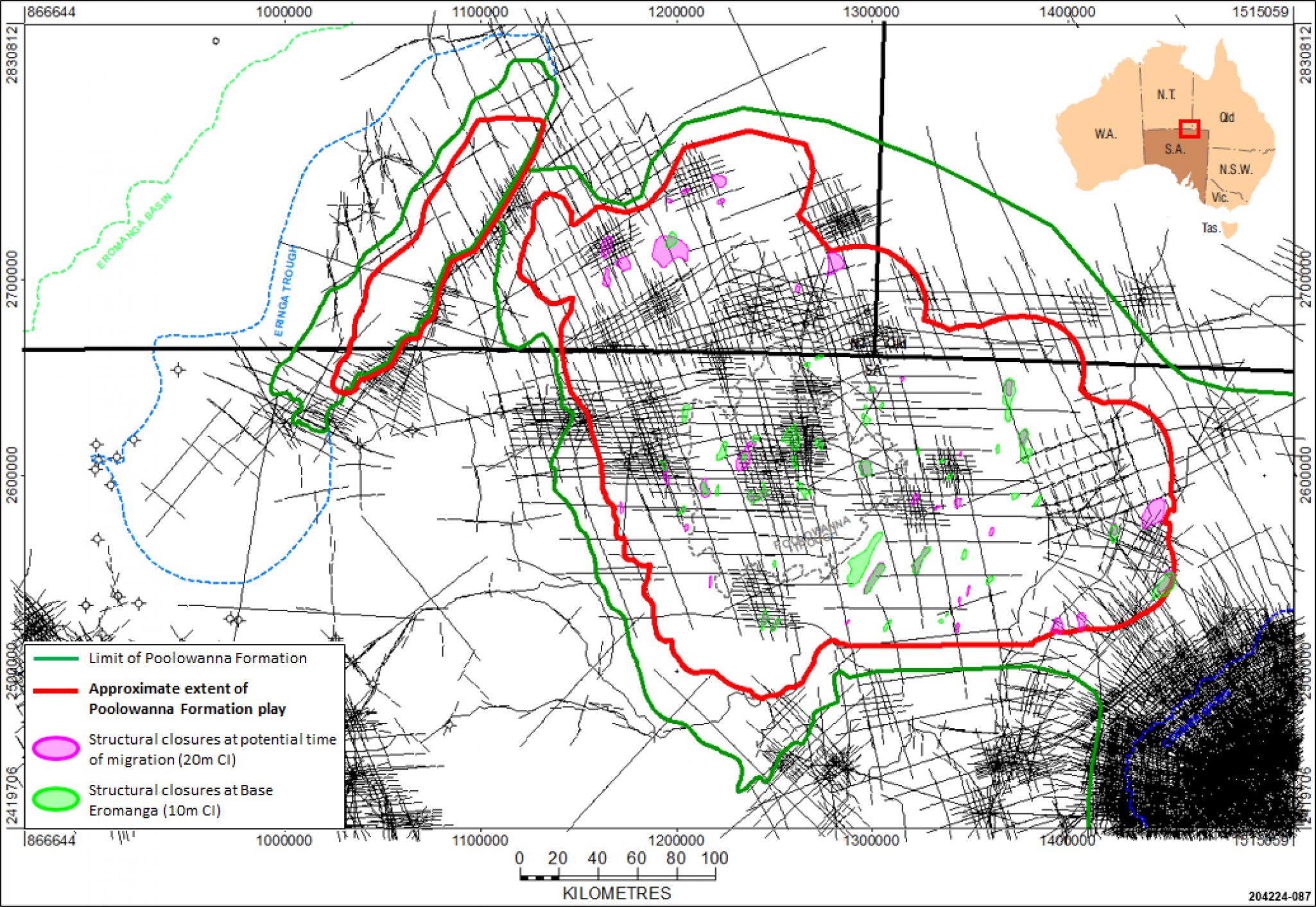
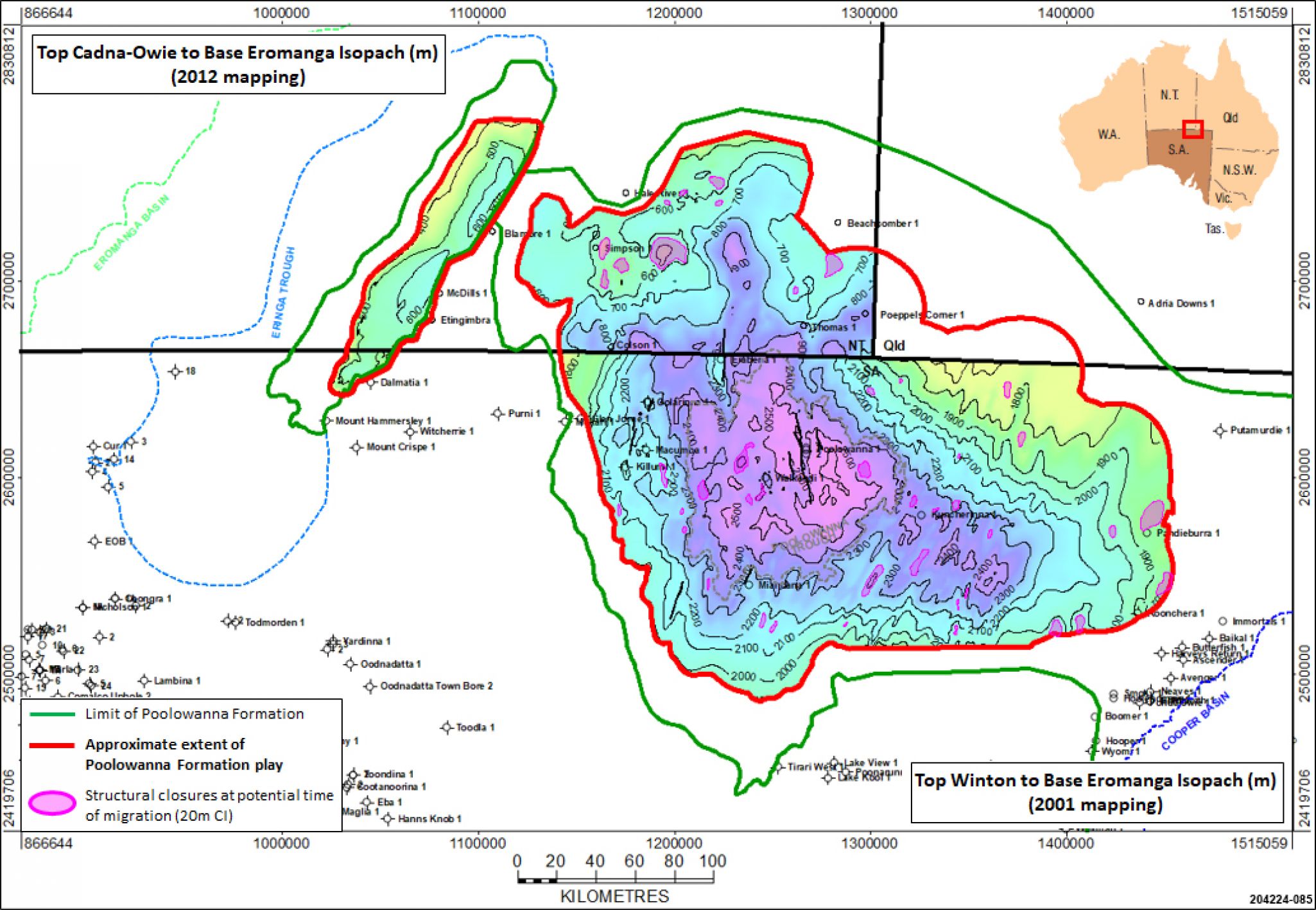
The Poolowanna Formation play exists in the Poolowanna Trough, proven by oil recovered in Poolowanna 1 in South Australia and residual oil in Colson 1 in the Northern Territory.
The play also exists in the Eringa Trough of the Pedirka Basin although any hydrocarbons that occur are likely to have been generated from source rocks other than in the Lower Poolowanna Formation, which are only marginally mature in this area.
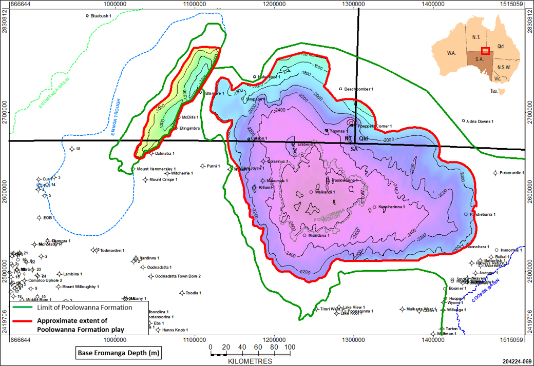
Approximate extent of the Poolowanna Formation play in the Poolowanna Trough region.
Poolowanna Fm in the Poolowanna Trough highlighted in red, and dashed red in the Eringa Trough.
Poolowanna 1 (1977)
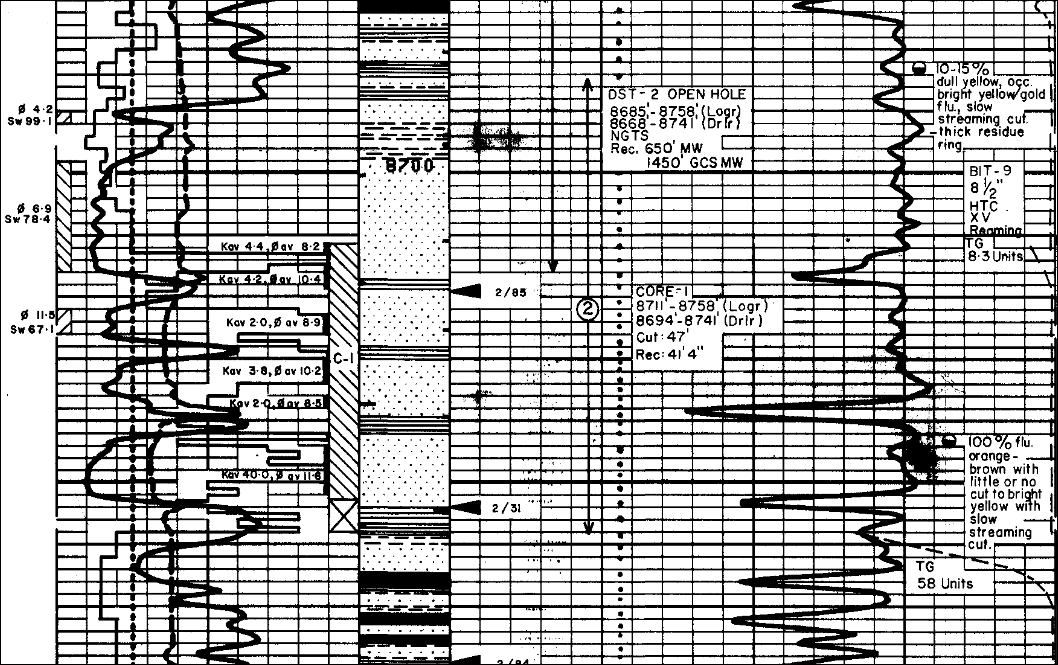
Poolowanna 1 was drilled as a rank wildcat well 77 miles from the nearest well to test a faulted north-south elongate anticline. The well recovered oil from the Poolowanna Formation and gas/oil-cut mud from the Triassic Peera Peera Formation, although in non-commercial quantities so the well was plugged and abandoned.
The Poolowanna Formation in Poolowanna 1 is the type section for the formation in the Eromanga Basin.
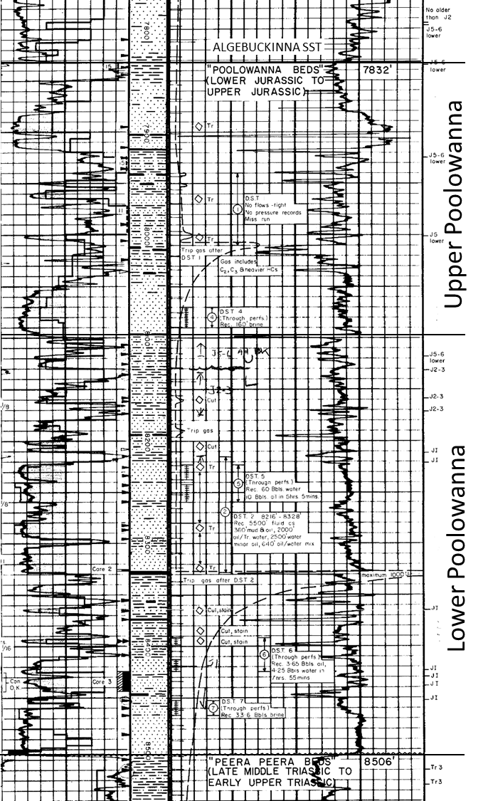
Poolowanna Formation in Poolowanna 1 (excerpt from Composite Log).
Information on tests and oil type in the Poolowanna Formation in Poolowanna 1 from the Well Completion Report:
- “2 open hole drill stem tests were conducted in the Poolowanna Formation, followed by 4 cased hole tests. DST 2 recovered in excess of 2000ft (610m) of oil from the Poolowanna Formation, with a subsequent cased hole test (DST 5) over a four hour period resulting in the flow of four barrels of oil to surface, equating to a theoretical flow rate of 96 BOPD. There was almost no associated gas. The oil is dark brown, very waxy, and possibly water washed with a pour point of 41oC. There is some evidence that the oil is associated with fracture development in the basal Jurassic sequence. Pay is interpreted in the intervals: 7946 - 7966 ft, 8053 - 8098 ft, 8303 - 8329 ft and 8340 - 8400 ft. Except for a thin sandstone between 8394 and 8397 ft, the oil does not appear to have saturated the reservoir units.”
Open hole tests:
- DST 1: 7,938 - 8,007ft, Poolowanna Formation; misrun.
- DST 2: 8,216 - 8,328ft, Poolowanna Formation; weak to fair blow, steady throughout 1-hour flow period, no gas to surface (GTS), unable to close tool due to partial sticking; pulled out of hole, recovered approx. 5500ft fluid:
- 360 ft mud and oil
- 2,000ft of oil with minor water and mud
- 2,500ft of salt water with minor oil
- 640ft of oil and water, mixed
Cased hole tests:
- DST 4: 8,070 - 8,090ft, Poolowanna Formation; weak blow throughout, no gas to surface, recovered 160ft of brine; tested- interval – tight.
- DST 5: 8,223 - 8,260ft, Poolowanna Formation; weak blow increasing to steady, GTS at rate too small to measure (RTSTM) after 2 hours and 5 minutes, oil to surface at approx. 4bbls/hr after 3 hours and 55 minutes, but mixed with water soon after; flow through separator for 180 mins gave 7½bbls oil and 2¼bbls water; on pulling pipe reversed out 2bbls oil and 69bbls formation water for total recovery of 71¼ barrels water and 9½ barrels oil; valid test, most of zone water-saturated, oil probably in fractures (no log oil/water contact).
- DST 6: 8,392 - 8,425ft, Poolowanna Formation; tool opened with fair blow, GTS at RTSTM in 3 hours 40 minutes, recovered 3.65 barrels light oil (condensate) and 4.25 barrels water after 7 hours 55 minutes flow period; valid test but tested interval of low permeability, partly water-saturated.
- DST 7: 8,452 - 8,466ft, Poolowanna Formation; tool opened with strong to fair blow, dead in 30 minutes, recovered 33.6bbls salt water (brine? and filtrate?) in 4 hours, no hydrocarbons; water-saturated zone of fair/limited permeability.
Oil type:
- N-alkanes distributions are regular … with no significant odd – even preference”
- “36.9o API gravity, with a pour point of 41oC, and hydrocarbons from nC9 to nC37 with peak in the nC22 to nC25 range.”
- Different oil to that recovered from the Peera Peera Formation below in Poolowanna 1, which “contains significant quantities of lighter hydrocarbons, in the range nC7 to nC10, and a second broad peak in the ranges nC16 to nC19 with little above nC31 present. … there is no odd to even preference”.
“It is notable that:
- there is a remarkable absence of gas in association with the oil
- the oil recovered from D.S.T. #2, and the fracturing present in Core #3 suggest the presence of oil in fractures over much of the Jurassic section.
- this oil does not appear to have saturated the sandstones, except for the thin sandstone between 8,394 and 8,397 feet.
- because of the interspersing of oil and water in complex association, electric logs are not readily interpreted.”
Two appraisal wells were drilled following the discovery of oil in Poolowanna 1, although both were designated as exploration wells on different culminations on the greater Poolowanna structure:
Poolowanna 2 (1985):
- WCR summary: “Six DST’s were conducted prior to TD. No open hole test recovered significant hydrocarbons. … Log interpretation indicates all potential reservoir sands are water saturated. No pay is mapped.”
- This refers to reservoirs in the Upper Poolowanna, Lower Poolowanna and Peera Peera
- Fluorescence was encountered in the Poolowanna Formation
- The well was plugged and abandoned
Poolowanna 3 (1989):
- WCR summary: “Three DST’s were run in response to shows whilst drilling in the Poolowanna Formation. DST 1 over the main target recovered only rat hole mud. DST recovered a trace film of oil. DST 3 flowed water at 80 BPD and recovered gas and oil cut water. Oil shows were recorded over the Peera-Peera Formation, but the sandstones are silicified and tight. … No net pay is mapped.”
- The well was plugged and completed as an Algebuckina water well
Analogue: Keleary Field, South Australian Cooper Basin
The Keleary Field on the Deramookoo Platform, northern Cooper Basin area, has produced over 1.63 million barrels of oil from the Poolowanna Formation.

Poolowanna Formation that has produced 1.034mmbo in Keleary 2, South Australian Cooper Basin area (excerpt from Composite Log).
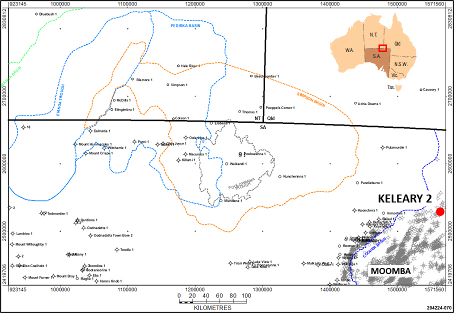
Location of Keleary 2 with respect to the Poolowanna Trough.
The Poolowanna Formation contains the deepest reservoir units in the Eromanga Basin sequence, occurring at depths from around 1400m (4,593ft) to below 2700m (8,859ft) subsea in the Poolowanna Trough; the base of the Poolowanna Formation in Walkandi 1 was encountered at 2703.75m/8,871ft. It lies disconformably on the Triassic Peera Peera Formation and was deposited in 2 transgressive cycles in a fluvial-lacustrine setting.
The Poolowanna was deposited under non-marine conditions with high-sinuosity fluvial channels meandering across a floodplain with minor coal swamps (Alexander et al (2007). In the Cooper region, palaeotopography on the Late Triassic unconformity surface strongly controlled Poolowanna facies, with a large northerly palaeovalley directed towards the Poolowanna Trough. Ravinement surfaces on the sides of palaeohighs are interpreted from wireline log data.
Sandstones are cross-bedded, often with graded foresets, ripple cross-lamination, climbing ripples, horizontal lamination, scoured surfaces, load casts, and ball and flame structures. Siltstone interbeds range from laminated to slurried and massive or destratified. Carbonised plant rootlets, water-escape structures and bioturbation (including trails and burrows) disrupt bedding.
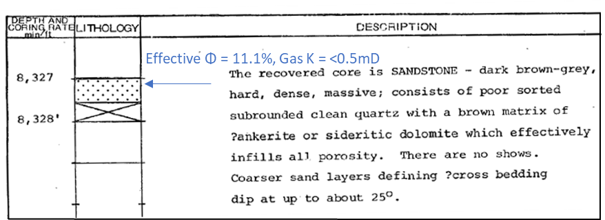
Poolowanna 1 was drilled in 1977 to test a faulted north-south elongate anticline. The Well Completion Report describes the Poolowanna Formation containing a number of point bar type sand/shale units, with sandstones as “fine to medium and generally medium to coarse grained quartzose, fair sorted (sic), moderately hard, friable to brittle, consisting of subangular to subrounded clean quartz with silica and clay cement. … Porosities range from 10% to about 14% but are generally below 13%. Fracture porosity is not readily measurable but may contribute as much as 3% to bulk porosity, and greatly improves permeability, especially over the interval 8,200 feet to 8,500 feet” (lowermost Poolowanna Formation). Analysis of cores 2 and 3 in Poolowanna 1 shows a range of 4.8 to 12.1% for sandstone porosity, with most samples showing 10% or less, and permeability <0.5mD, except for 2 samples with higher permeability probably due in part to fractures in the core plug.
Carne & Alexander (1997) reported that porosity averages 13% and permeability ranges from 0.001md to 3674md, with the deeper samples showing the lowest average porosities due to the formation of quartz overgrowths, as may be expected. Ambrose et al (2002) stated that porosities vary up to 12% in Poolowanna 2 and 3 but are generally less than 10%. Diagenesis of the sandstones, associated with Winton Formation deposition, preceded and retarded oil migration which occurred later via fractures during the Tertiary.
Description and analysis of core 2 in the lowermost Poolowanna Formation in Poolowanna 1 (excerpt from Well Completion Report)

Description and analyses of core 3 in the lowermost Poolowanna Formation in Poolowanna 1 (excerpt from Well Completion Report)
No photographs of Poolowanna Formation core in Poolowanna 1 have been taken, which clearly needs to be rectified.
Cores were also cut in the Lower Poolowanna in Walkandi 1 (1981), Erabena 1 (1981) and Pandieburra 1 (1963), with the only photographs taken in Pandieburra 1.
- Walkandi 1 – 47ft (14.3m) of core was cut, with 41ft 4” (12.6m) recovered. Core analysis showed a range of 4.9 to 12.4% for sandstone porosity with most samples showing 8-10%, and permeability ranging from 0.07 to 102mD, although generally around 2-4mD. The lowermost 8ft of the core averaged 11.6% porosity and 40mD permeability.
Cored interval in Lower Poolowanna in Walkandi 1 (excerpt from Composite Log)
- Erebena 1 – 46ft (14.0m) of core was cut, with 33ft 6” (10.2m) recovered. Core analysis indicated better reservoir quality than in Walkandi 1, with sandstone porosity ranging 7.9 to 18.0% with most samples showing around 13%, and permeability ranging from 0.4 to 147mD, with all but 3 of the samples having permeabilities less than 5mD.

Cored interval in Lower Poolowanna in Erabenai 1 (excerpt from Composite Log)
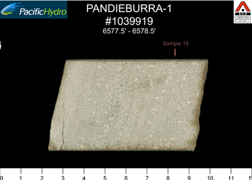
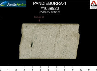
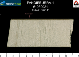
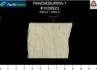
- Pandieburra 1 – 10ft (3.05m) of core was cut with 100% recovery. No core analysis information is available in the Well Completion Report, but 5 photographs were taken of the core.
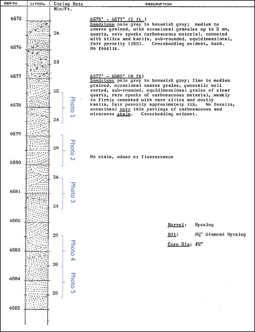
Description of Core 5 cut in the Poolowanna Formation in Pandieburra 1 (excerpt from WCR)
Core 5 Photo 1, Pandieburra 1 |
Core 5 Photo 2, Pandieburra 1 |
Core 5 Photo 3, Pandieburra 1 | 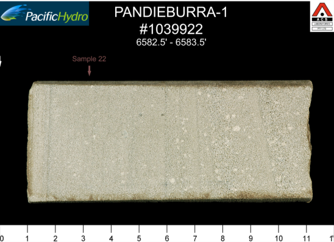 Core 5 Photo 4, Pandieburra 1 Core 5 Photo 4, Pandieburra 1 |
Core 5 Photo 5, Pandieburra 1 |
The Poolowanna 1 WCR describes the recovery of oil in DST 2 “at a theoretical flow rate of 96 BOPD. There was almost no associated gas. The oil is dark brown, very waxy, and possibly water washed with a pour point of 41oC. There is some evidence that the oil is associated with fracture development in the basal Jurassic sequence. Pay is interpreted in the intervals: 7946 - 7966 ft, 8053 - 8098 ft, 8303 - 8329 ft and 8340 - 8400 ft. Except for a thin sandstone between 8394 and 8397 ft, the oil does not appear to have saturated the reservoir units. Because of the interspersing of oil and water in complex association, electric logs are not readily interpreted.”
An open hole DST was conducted over the Poolowanna Formation in Mokari 1 (1964) following a gas show while drilling. Water flowed to surface in 12 minutes, at a rate of 387cu ft/hr, which equates to a rate of 1,654BWPD.
Colson 1 (1978) in the Northern Territory encountered residual hydrocarbon staining during drilling, consisting of pale brown staining of the quartz sandstone but with no gas show or fluorescence. The WCR indicates that visual porosity in the interval of oil staining (6,541 to 6570ft, 1993.7 to 2002.5m) was as high as 20%, averaging around 14 to 16%, although below this porosity is lower, around 12 to 15%. Ambrose et al (2002) interpreted a palaeo-gas-oil contact and a palaeo-oil-water contact in Colson 1 (see the Well Log Correlation), indicating that the reservoir was initially charged with oil and gas from a single charge event, and this was subsequently lost probably due to seal breach. The residual oil-water contact at the top of the reservoir is either the remnant of the original hydrocarbon column or the reservoir subsequently received further minor oil recharge around 3Ma.
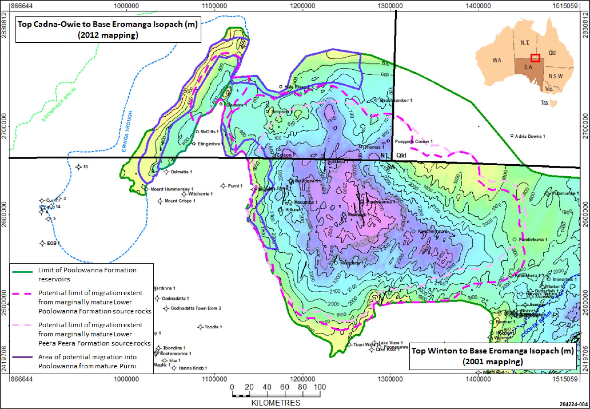
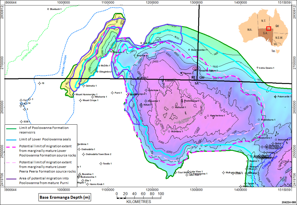
Extent of the Poolowanna Formation reservoir in the Poolowanna and Eringa Troughs
Siltstones within the Poolowanna Formation are intraformational seals, but the occurrence of stacked oil pools in fields in the Cooper Basin region indicate they are not wholly effective; for example, in fields with stacked pools, the thickness of the Poolowanna facies in wells ranges from ~18–25m while in fields where Poolowanna reservoirs exist in isolation the formation is ~60–75m thick (Alexander and Boult, 2007). Seal effectiveness is reduced by limited areal extent, thickness and siltstone mineralogy. The Poolowanna Formation is thicker than 75m in all the wells in the Poolowanna Trough region where it has been interpreted, and so it is likely on that basis that there is sufficient thickness of silts and shales to act as seals.
In the Poolowanna Trough silts and shales at the top of the Lower Poolowanna act as suitable seals to have trapped hydrocarbons, witness the recovery of oil from the Lower Poolowanna in Poolowanna 1 and the interpreted palaeo and residual contacts in Colson 1 in the NT (Ambrose et al, 2002). Different aquifer water salinities between the Lower and Upper Poolowanna sandstones support this sealing mechanism (Ambrose et al, 2007).
Seal for the Upper Poolowanna reservoirs is a different issue as there are only traces of oil encountered in this interval, suggesting that silts and shales present are either not good enough quality to act as seals or are not thick enough. Potential exists for silty-coaly shales to have been preserved at the top of the Upper Poolowanna thus providing suitable top seal, however it is likely over most of the Poolowanna Trough area that the uppermost section of the formation has been eroded by the massive braided sands of the overlying Algebuckina Sandstone.
It is possible that there are stratigraphic traps on the flanks of the Poolowanna Trough where the silts and shales at the top of the Lower Poolowanna pinch-out against the silts and shales at the top of the Triassic or Permian intervals below, providing topseal and lateral seal for the Lower Poolowanna reservoirs.
In general faulting has not had much of an impact on Eromanga Basin reservoirs other than to set up closures, but this is not necessarily the case in the Poolowanna Trough and Eringa Trough area, where intense east-west compression and local wrenching during the Miocene resulted in structural rejuvenation and breach of fault seal. This would explain why only residual hydrocarbons were encountered in the Poolowanna Formation in Poolowanna 1.
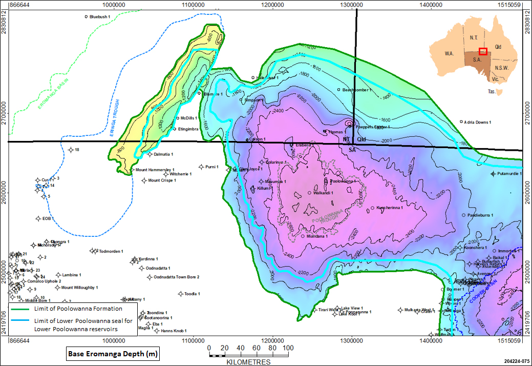
Extent of the Lower Poolowanna Formation, hence likely area of sealed Lower Poolowanna Formation reservoirs in the Poolowanna Trough and the Eringa Trough
Oil was recovered on DST from the Poolowanna Formation in Poolowanna 1, with the Well Completion Report suggesting that “the oil is a geologically mature oil (no odd/even preference) probably spilling from another reservoir (no gas); it occupies the best porosity and permeability in the Jurassic section (suggesting it is migrating into the section at present).”
Three intervals contain suitable material in the Poolowanna Trough region to have acted as potential source rocks for charge of hydrocarbons into the Poolowanna reservoirs:
- the Early Jurassic Lower Poolowanna Formation of the Eromanga Basin,
- the Middle to Late Triassic Peera Peera Formation of the Simpson Basin, and
- the Early Permian Purni Formation of the Pedirka Basin.
Lower Poolowanna Formation, Eromanga Basin
The Poolowanna Formation is considered to have poor potential as a source rock in the Cooper Basin area of the Eromanga Basin. However, in the Poolowanna Trough region the middle section of the Poolowanna has much better potential: the Poolowanna 1 Well Completion Report indicated “A 40 foot interval within the Poolowanna Formation offers the best source rock potential of the well. The kerogen from this interval included about 25 % diffuse sapropelic material that is rich in exinite, but also in inertinite.”
The Poolowanna Formation source rocks are primarily at the top of the Lower Poolowanna, and so are most likely to be the source for any hydrocarbon accumulations within the Poolowanna due to proximity of the reservoir to the source material. Coals and coal-related lithologies are volumetrically important in the sequence, with maceral composition ranging from vitrinite and vitrinite-rich clarite through a range of trimacerites to durite (Radke, 2009). Inertinite is dominant in dispersed organic matter (DOM) but vitrinite is also abundant. At Poeppels Corner 1, woody herbaceous DOM is rich in exinite. The coals have good to excellent source richness with total organic carbon (TOC) up to 15%, possess good oil generative potential, and have reached peak maturity of 0.9 % Ro in the Poolowanna Trough.
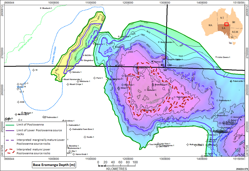
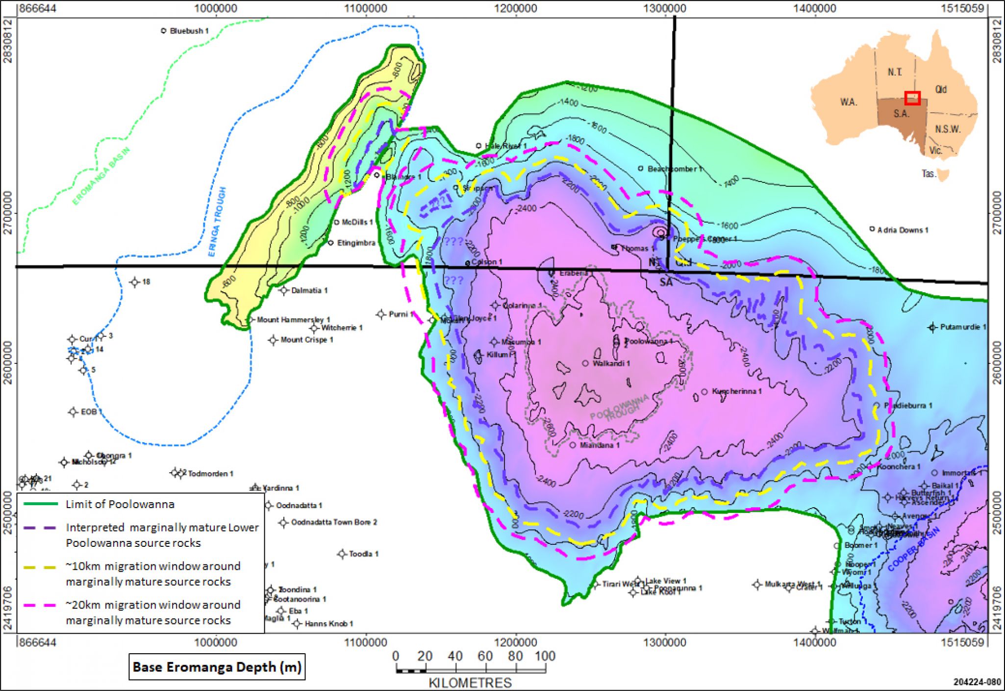
Maturity of the Lower Poolowanna Formation in the Poolowanna Trough and the Eringa Trough
Peera Peera Formation, Simpson Basin
The Triassic Peera Peera Formation offers fair to good source potential. The Poolowanna 1 Well Completion Report indicated “The uppermost 60 feet of this section consists of black, silty, very organic rich shale, and appears to be an excellent source rock”, and that the formation “appears to be less prospective for liquid hydrocarbons than the Lower Jurassic section, although higher yields of kerogen have been attained in the upper part of the Peera Peera Formation.” The WCR also noted “A large sonic travel time shift (18 microseconds per foot, maximum) indicates the high organic content of this silty shale, which seems to be the main source of hydrocarbons in the area.”
The Peera Peera is rich in Type III kerogen organic matter (TOC around 4-5% although up to 18% in places). Ambrose et al (2007) reported Hydrocarbon Index of 100-200 with yield of 5-11kg/tonne in Macumba 1 (1977), suggesting a source for mixed gas and liquids, which is consistent with the gas flowed to surface from the Peera Peera in Poolowanna 1, albeit at a rate too small to measure. Radke (2009) noted that generally the DOM is higher towards the top of the unit and inertinite is dominant, and that much of the source potential of this unit lies in its abundant coals which have comparable macerals to those in the overlying Poolowanna Formation. He stated that the formation appears to be predominantly gas-prone but with potential for a modest oil yield.

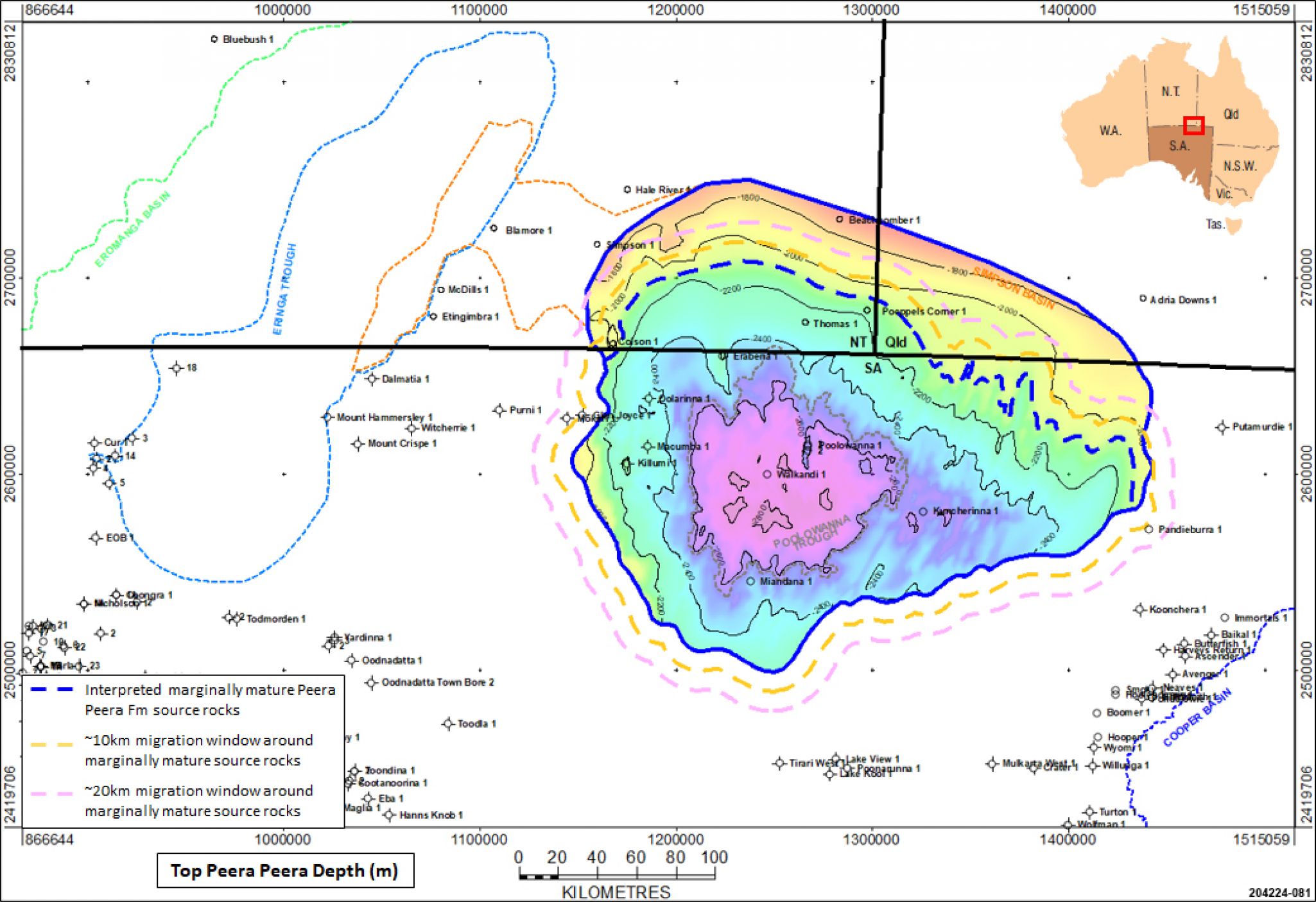
Maturity of the Peera Peera Formation source rocks in the Poolowanna Trough
Purni Formation, Pedirka Basin
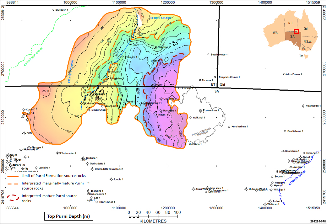
The Early Permian Purni Formation in the Pedirka Basin is the equivalent of the Patchawarra Formation, which is the source for much of the gas and oil discovered in the Cooper and Eromanga Basins. It contains the richest source rocks in the Pedirka Basin-Poolowanna Trough area, with extensive coal-rich organic shale which appears to be both oil and gas-prone. It contains up to 4% dispersed organic matter, with vitrinite and exinite macerals present in moderate abundance. Data from Dalmatia 1 and Mt Hammersley 1 indicate poor to good source potential for oil in the Purni Formation.
Radke (2009) reported both the upper and lower members of the Purni Formation as having good to excellent source rock potential. They consist of alternating shale, coal and siltstones deposited in lacustrine, swamp and floodplain settings, with the coals being the richest source rocks, comprising predominantly vitrinite and inertinite, with exinite generally less than 5% (but up to 20%). DOM in carbonaceous shales is generally poor. In the eastern Pedirka, Purni Formation sediments contain both H–rich exinite and vitrinite, and H-poor vitrinite rich source rocks
2008 drilling in the Northern Territory by Central Petroleum established extremely thick coal accumulations away from structural highs, with cumulative thicknesses exceeding 100m for individual seams thicker than 2m. The isopach of the Purni Formation indicates over 660m of section in the Eringa Trough in the Northern Territory.
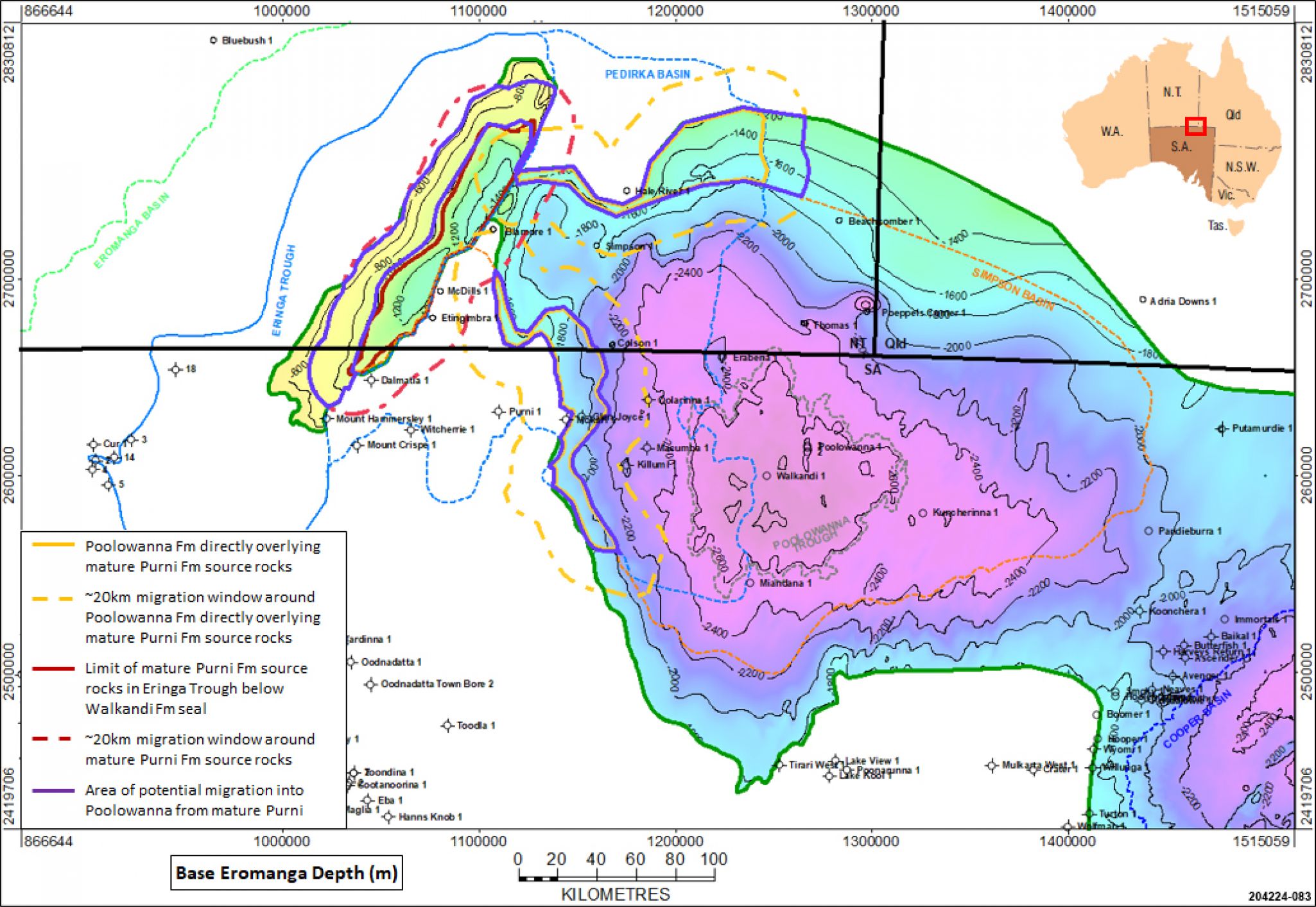
Lower Poolowanna reservoirs directly overlie Permian Purni Formation source rocks in the western Poolowanna Trough and in the Eringa Trough. Therefore, it is highly likely that there would have been direct migration of hydrocarbons from the mature Purni Formation source rocks into the Poolowanna Formation reservoirs in these areas.
Maturity of the Purni Formation source rocks in the Pedirka Basin (2015 mapping).
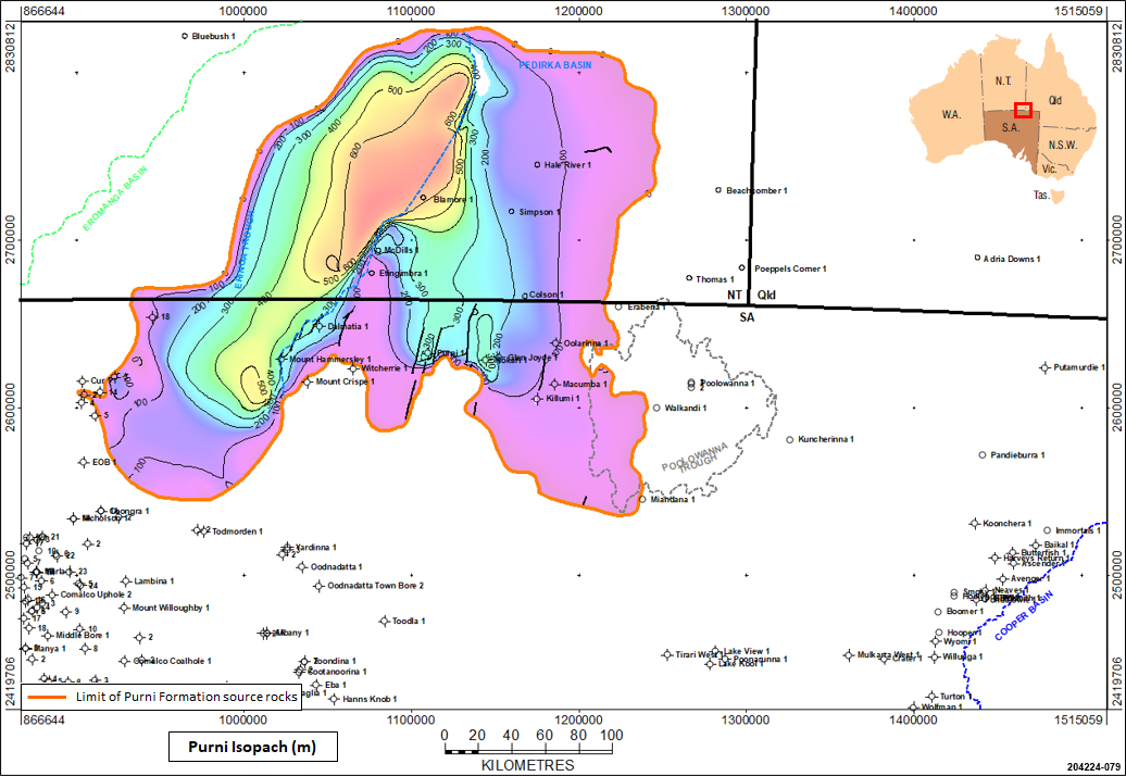
Thickness of the Purni Formation in the Pedirka Basin (2015 mapping).
Source rock maturity
Onset of oil generation (Ro=0.5%) would generally be expected with burial at 1500m, and peak oil generation (Ro=0.7%) at 2200m (Radke, 2009), although of course this depends upon the types of organic matter present and the local geothermal gradient. Gas generation is expected from 0.6% Ro at 1900m.
In much of the Pedirka Basin geothermal gradients are low and so sediments may not have generated significant quantities of hydrocarbons, but the Early Jurassic (Poolowanna) and Permo-Triassic sequences have reached the main oil generative window (Ro 0.7-0.9%) over large portions of the Pedirka Basin and Poolowanna Trough.
Basin modelling in the Poolowanna Trough by Ambrose et al (2007) suggested that early onset of oil generation commenced from the Peera Peera Formation in the Early Cretaceous around 135Ma, suggesting that this may have occurred potentially earlier from the Purni Formation in the eastern Pedirka Basin. Peak generation and expulsion from all source rocks occurred primarily during the early part of the Late Cretaceous(100-90Ma) following significant subsidence during the deposition of the Winton Formation.
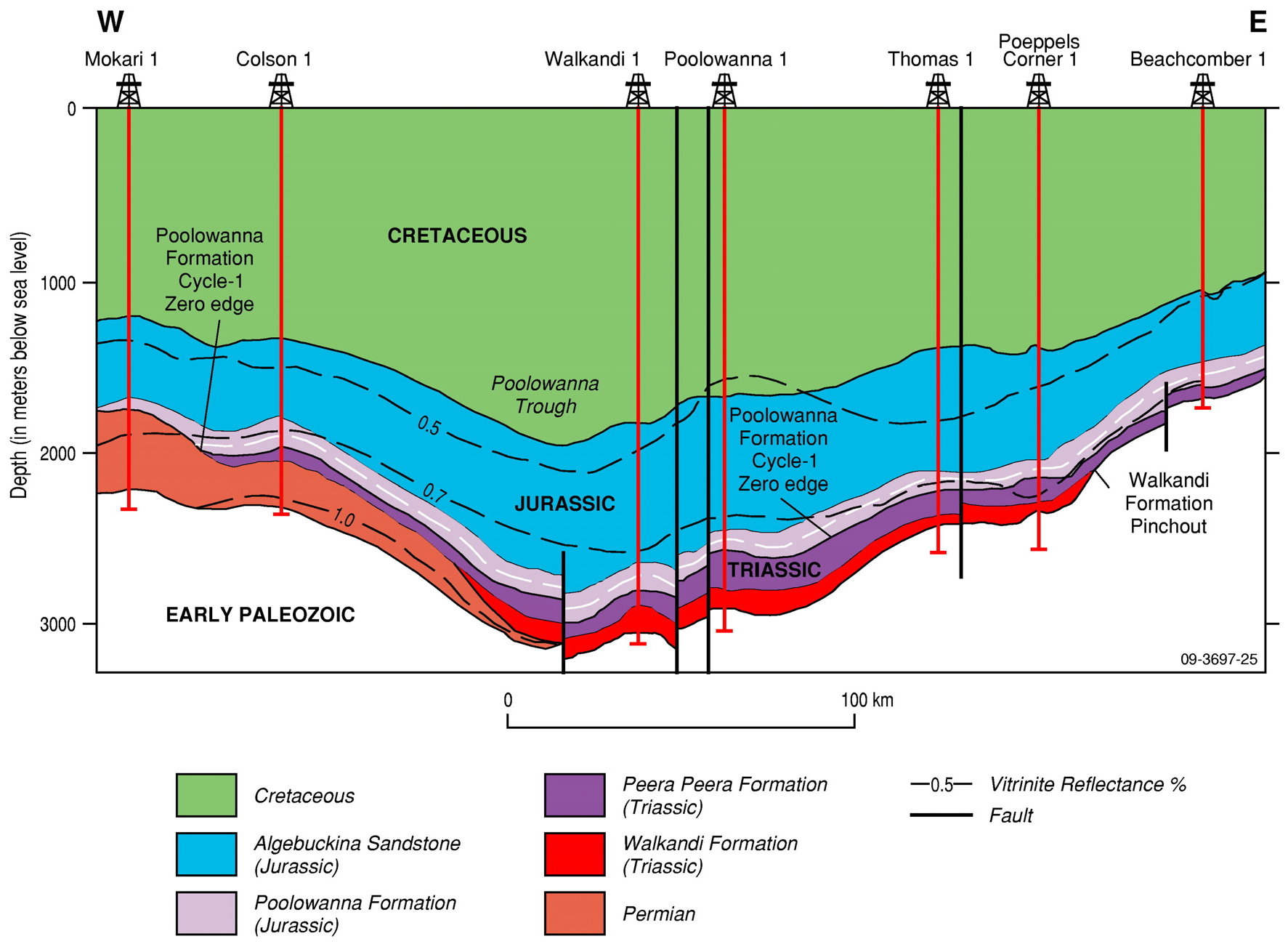
Cross section of the Poolowanna Trough with isoreflectance contours, showing maturity of the sequence up to the basal Jurassic, and a progressively shallower mature sequence to the east (from Radke, 2009, modified from Ambrose et al, 2007).
Three intervals contain suitable material in the Poolowanna Trough region to have acted as potential source rocks for charge of hydrocarbons into the Poolowanna reservoirs:
- Direct charge from Lower Poolowanna source rocks into underlying Lower Poolowanna reservoirs in the Poolowanna Trough and Eringa Trough
- The Lower Poolowanna sandstone is directly overlain by potential source rocks of the same age, and therefore charge into reservoirs is likely from areas where the source is mature, including updip of the mature source due to the porous and permeable carrier bed system
- This occurred in the Poolowanna Trough in both South Australia and the Northern Territory. However, in the Eringa Trough, the Lower Poolowanna Formation source rocks are only mature enough in the deepest portion of the Northern Territory sector to have generated hydrocarbons
- Vertical migration from Peera Peera source rocks into the directly overlying Lower Poolowanna reservoirs in the Poolowanna Trough
- Mature source rocks in the Late Triassic Peera Peera Formation lie directly below the Lower Poolowanna. Therefore, hydrocarbon charge is also likely from the Peera Peera into Lower Poolowanna reservoirs, vertically up into porous and permeable carrier beds
- Again, this is likely in the Poolowanna Trough, but the Peera Peera has not been encountered in the Eringa Trough area. If present it would only be in the deepest parts of the trough, where it may have generated some hydrocarbons.
- Vertical migration from Purni source rocks into the directly overlying Lower Poolowanna reservoirs in the western Poolowanna Trough and in the Eringa Trough
- Lower Poolowanna reservoirs directly overlie Permian Purni Formation source rocks in the western Poolowanna Trough and in the Eringa Trough. Therefore, it is highly likely that there would have been direct migration of hydrocarbons from the mature Purni Formation source rocks into the Poolowanna Formation reservoirs in these areas
- In the centre of the Poolowanna Trough the Purni Formation is overlain by the Triassic sediments of the Simpson Basin, so any charge into the Poolowanna would need to have been by relatively convoluted migration paths
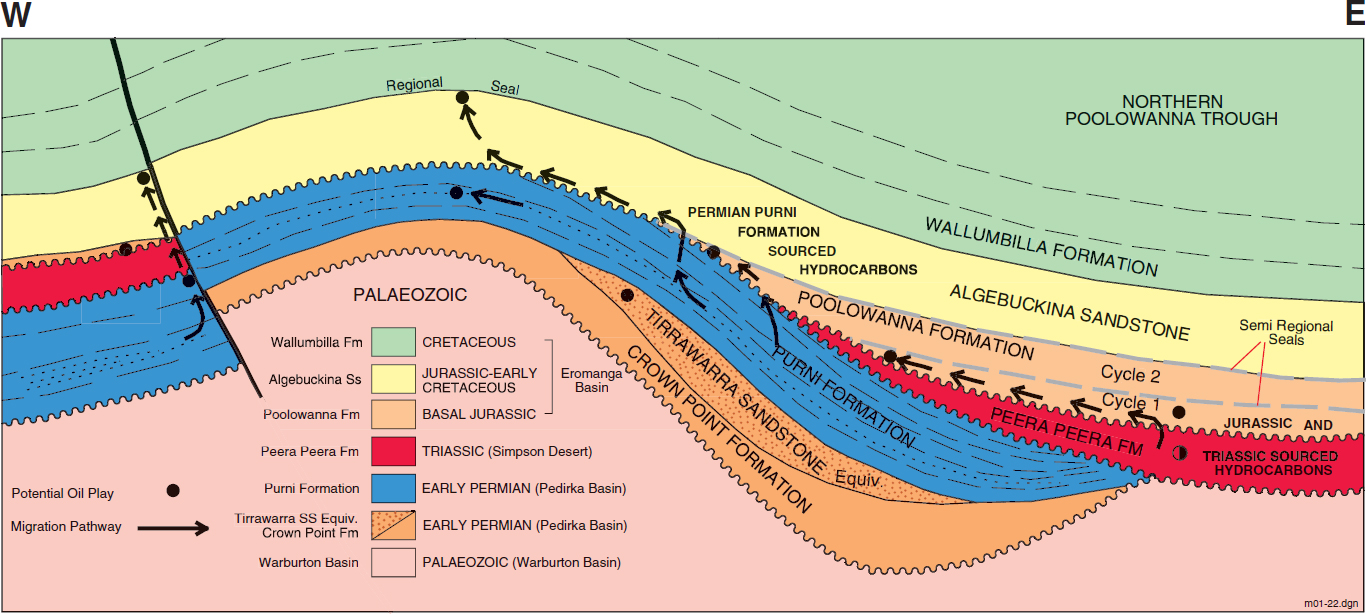
Pedirka, Simpson and Eromanga Basins play types and potential migration pathways (Ambrose et al, 2002)
Up to 20km migration distance from mature source rocks is generally regarded as a reasonable migration distance within porous reservoirs, although Borazjani et al (2019) stated that in the Cooper-Eromanga basins “the migration of expelled oils to Jurassic reservoirs was relatively fast given the short pathway distances of <1 km (fault migration) and ~40 km (carrier bed pathway)”. In this play analysis study 20km migration distances have been used outboard of mature source rock areas.
|
|
|  |

Trapping mechanisms in the Poolowanna Trough are likely to be dominated by anticlines with 4-way dip closure over pre-existing, “basement” highs, although onlap and pinch-out traps against Warburton Basin highs are expected along the eastern flank of the Dalhousie-McDills Ridge.
Structures to be investigated must have been in place prior to major generation and expulsion of hydrocarbons, so those that formed during the Cainozoic are less favourable prospects than those formed prior to end of deposition of the Late Cretaceous Winton Formation.
In general faulting has not had much of an impact on Eromanga Basin reservoirs other than to set up closures, but this is not necessarily the case in the Poolowanna Trough region, where intense east-west compression and local wrenching during the Miocene resulted in structural rejuvenation and breach of fault seal.
Therefore, exploration is required of more subtle structures not affected by the reactivation in the Miocene.
In the Cooper-Eromanga Basins a common technique for estimating whether a present day structure is likely to have been charged with hydrocarbons or not is to look at the isopach between the top of the Winton Formation and the top of the target formation; this map approximates the target surface structure at time of migration, with thin isopach areas indicating potential structures at time of migration. If there is no top Winton surface mapped in the area of interest the isopach between the top of the Cadna-owie Formation and the target formation is used as a proxy. This technique is applicable in the Poolowanna Trough region.
Eromanga Basin structures in South Australia and Queensland are typically not filled with oil to spill; net oil columns are relatively thin compared to the area under closure. This is due to compressive deformation in the early/mid-Tertiary reactivating older structures, and is an important concept given that exploration in the area, and in particular seismic acquisition, has focused on large structures.
It must be borne in mind that the coverage of 2D seismic data within the Poolowanna Trough and the Eringa Trough is limited compared to that in the Cooper Basin to the south-east. Consequently, structures in reality may be quite different to the way they have been mapped.
|
|
|  |
Play elements for the Poolowanna Formation in the Poolowanna Trough region.

Approximate extent of the Poolowanna Formation play in the Poolowanna Trough region.
| Proven production from the Poolowanna: | Recovered 4 barrels of oil in Poolowanna 1 |
| Number of producing wells at 31 January 2021: | None |
| Total production at 31 January 2021: | None |
| Hydrocarbon flow rates: | Poolowanna 1 flowed 4 barrels of oil to surface in 4 hours, equating to a theoretical flow rate of 96 BOPD. Water recovered in Mokari 1 at a rate of 387 cu ft/hr, which equates to a rate of 1,654BWPD. |
| Potential flow rates: | Macumba 1 flowed water at 575BPD |
Undiscovered recoverable oil resources of the western Eromanga Basin (ERD estimate June 2006, Morton and Hill, 2007)
| UNDISCOVERED POTENTIAL 106 kL (mmbbl) | ||||||
PLAY | Probability that the ultimate potential will exceed the stated value: | |||||
| 90% | 50% | 10% | ||||
Poolowanna | 0.3 | (1.3) | 0.6 | (3.8) | 1.9 | (12.0) |
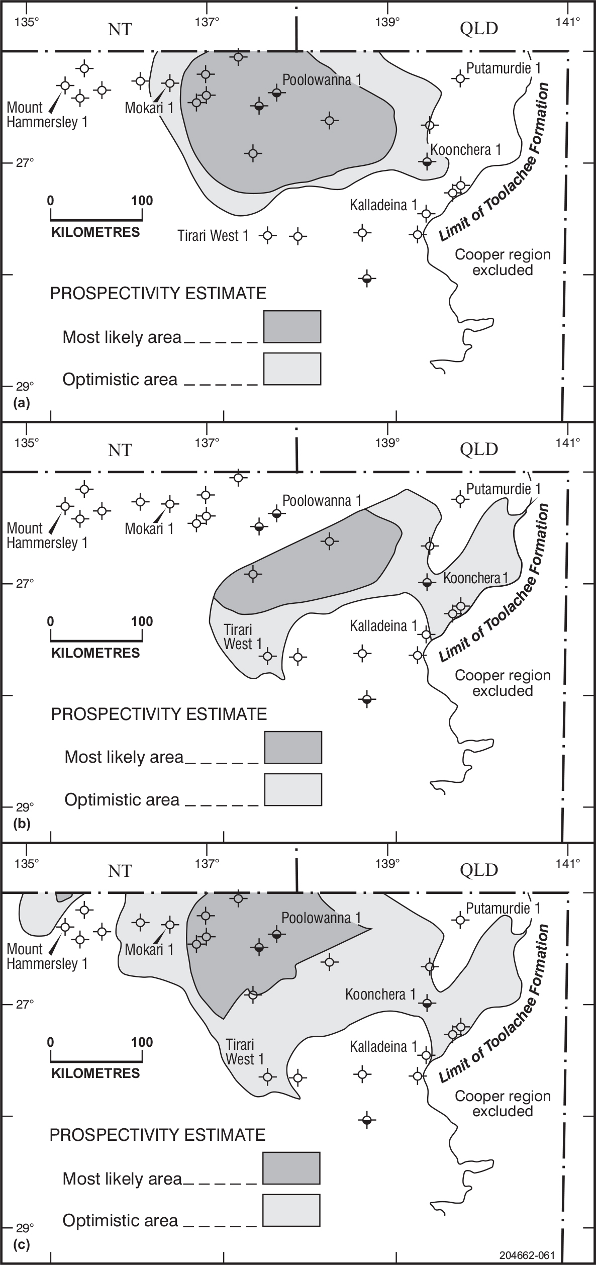
Prospectivity of the western Eromanga Basin: (a) Poolowanna Formation; (b) Hutton Sandstone; (c) Namur–Algebuckina Sandstones
Alexander, EM, and Jensen-Schmidt, B, 1995: Eringa Trough exploration opportunity; South Australia. Department of Mines and Energy. Report Book, 95/00036.
Alexander EM and Boult, PB, 2007. Reservoirs and seals; Chapter 11 in Cotton, TB, Scardigno, MF, and Hibburt, JE, eds: The Petroleum Geology of South Australia. Vol. 2: Eromanga Basin. 2nd edn; South Australia; Department of Primary Industries and Resources. Petroleum Geology of South Australia Series.
Alexander EM, Sansome, A and Cotton, TB, 2007. Lithostratigraphy and environments of deposition; Chapter 5 in Cotton, TB, Scardigno, MF, and Hibburt, JE, eds: The Petroleum Geology of South Australia. Vol. 2: Eromanga Basin. 2nd edn; South Australia; Department of Primary Industries and Resources. Petroleum Geology of South Australia Series.
Ambrose, GJ, Liu, K, Deighton, I, Eadington, PJ, and Boreham, CJ, 2002: New petroleum models in the Pedirka Basin, Northern Territory, Australia; APPEA Journal, 42(1):259-286.
Ambrose, G., Scardigno, M., and Hill, A.J., 2007: Petroleum geology of Middle-Late Triassic and Early Jurassic sequences in the Simpson Basin and northern Eromanga Basin of Central Australia; APPEA Journal, 47(1):125-142.
Borazjani, S, Kulikowski, D, Amrouch, K and Bedrikovetsky, 2019: Composition changes of hydrocarbons during secondary petroleum migration (case study in Cooper Basin, Australia); Geosciences, 9(2), 78
Carne, GE and Alexander, EM, 1997: Eromanga Basin prospects inventory, Blocks ER97-A to C, Exploration opportunity; South Australia. Department of Mines and Energy Resources. Report Book, 97/00021.
Giuliano MF, 1988. The geology and hydrocarbon potential of the Pedirka Basin. University of Adelaide. National Centre for Petroleum Geology and Geophysics. BSc (Hons) thesis (unpublished).
Morton, JGG and Hill, AJ, 2007. Undiscovered Petroleum Resources. Chapter 14 Cotton, TB, Scardigno, MF, and Hibburt, JE, eds: The Petroleum Geology of South Australia. Vol. 2: Eromanga Basin. Second edition; South Australia Department of Primary Industries and Resources. Petroleum Geology of South Australia Series.
Radke, B., 2009: Hydrocarbon & Geothermal Prospectivity of Sedimentary Basins in Central Australia. Record 2009/25. Geoscience Australia, Canberra.
Strong, P. 2022. Play Analysis in the Pedirka Basin-Poolowanna Trough region. Presented at CABS IV, Darwin, Northern Territory, 30 August 2022.